
Bude
Overview
Cornwall
Cornwall is a unitary authority and ceremonial county of England, within the United Kingdom. It is bordered to the north and west by the Celtic Sea, to the south by the English Channel, and to the east by the county of Devon, over the River Tamar. Cornwall has a population of , and covers an area of...
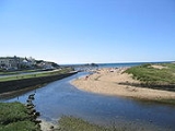
, England, at the mouth of the River Neet (also known locally as the River Strat). It lies just south of Flexbury, north of Widemouth Bay
Widemouth Bay
Widemouth Bay is a bay and beach on the Atlantic coast of Cornwall, England, UK, approximately 3 miles south of Bude. This stretch of coast is steeped in the smuggling history of times before, and not far south of Widemouth Bay can be found many little inlets and coves.-Activities:The beach is...
and west of Stratton
Stratton, Cornwall
Stratton is a small town situated near the coastal resort of Bude in north Cornwall, UK. It was also the name of one of ten ancient administrative shires of Cornwall - see "Hundreds of Cornwall"...
and is located along the A3073 road off the A39
A39 road
The A39 is an A road in south west England. It runs south-west from Bath in Somerset through Wells, Glastonbury, Street and Bridgwater. It then follows the north coast of Somerset and Devon through Williton, Minehead, Porlock, Lynmouth, Barnstaple, Bideford, Stratton, Camelford, Wadebridge and St...
. Bude is twinned with Ergué-Gabéric
Ergué-Gabéric
Ergué-Gabéric is a commune in the Finistère department of Brittany in north-western France. It lies on the Odet river.-Population:-Sights:The church of Saint Gwenhael has an organ by Thomas Dallam II and his son Toussaint....
in Brittany
Brittany
Brittany is a cultural and administrative region in the north-west of France. Previously a kingdom and then a duchy, Brittany was united to the Kingdom of France in 1532 as a province. Brittany has also been referred to as Less, Lesser or Little Britain...
, France
France
The French Republic , The French Republic , The French Republic , (commonly known as France , is a unitary semi-presidential republic in Western Europe with several overseas territories and islands located on other continents and in the Indian, Pacific, and Atlantic oceans. Metropolitan France...
. Bude's coast faces the Atlantic Ocean
Atlantic Ocean
The Atlantic Ocean is the second-largest of the world's oceanic divisions. With a total area of about , it covers approximately 20% of the Earth's surface and about 26% of its water surface area...
.
Its earlier importance was as a harbour, and then a source of sea sand useful for improving the moorland soil.
Discussions