

Geography of Turkmenistan
Encyclopedia
Turkmenistan
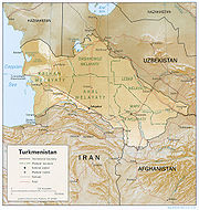
Turkmenistan , formerly also known as Turkmenia is one of the Turkic states in Central Asia. Until 1991, it was a constituent republic of the Soviet Union, the Turkmen Soviet Socialist Republic . Turkmenistan is one of the six independent Turkic states...
is a landlocked
Landlocked
A landlocked country is a country entirely enclosed by land, or whose only coastlines lie on closed seas. There are 48 landlocked countries in the world, including partially recognized states...
country in Central Asia
Central Asia
Central Asia is a core region of the Asian continent from the Caspian Sea in the west, China in the east, Afghanistan in the south, and Russia in the north...
, bordering the Caspian Sea
Caspian Sea
The Caspian Sea is the largest enclosed body of water on Earth by area, variously classed as the world's largest lake or a full-fledged sea. The sea has a surface area of and a volume of...
to the west, Iran
Iran
Iran , officially the Islamic Republic of Iran , is a country in Southern and Western Asia. The name "Iran" has been in use natively since the Sassanian era and came into use internationally in 1935, before which the country was known to the Western world as Persia...
and Afghanistan
Afghanistan
Afghanistan , officially the Islamic Republic of Afghanistan, is a landlocked country located in the centre of Asia, forming South Asia, Central Asia and the Middle East. With a population of about 29 million, it has an area of , making it the 42nd most populous and 41st largest nation in the world...
to the south, Uzbekistan
Uzbekistan
Uzbekistan , officially the Republic of Uzbekistan is a doubly landlocked country in Central Asia and one of the six independent Turkic states. It shares borders with Kazakhstan to the west and to the north, Kyrgyzstan and Tajikistan to the east, and Afghanistan and Turkmenistan to the south....
to the north-east, and Kazakhstan
Kazakhstan
Kazakhstan , officially the Republic of Kazakhstan, is a transcontinental country in Central Asia and Eastern Europe. Ranked as the ninth largest country in the world, it is also the world's largest landlocked country; its territory of is greater than Western Europe...
to the north-west. It is the southernmost republic of the Commonwealth of Independent States
Commonwealth of Independent States
The Commonwealth of Independent States is a regional organization whose participating countries are former Soviet Republics, formed during the breakup of the Soviet Union....
(CIS), the loose federation created at the end of 1991 by most of the post-Soviet
Soviet Union
The Soviet Union , officially the Union of Soviet Socialist Republics , was a constitutionally socialist state that existed in Eurasia between 1922 and 1991....
states.
Its longest border is with the Caspian Sea (1,786 km). The other borders are with Iran (to the south, 992 km), Afghanistan
Afghanistan
Afghanistan , officially the Islamic Republic of Afghanistan, is a landlocked country located in the centre of Asia, forming South Asia, Central Asia and the Middle East. With a population of about 29 million, it has an area of , making it the 42nd most populous and 41st largest nation in the world...
(to the south, 744 km), Uzbekistan
Uzbekistan
Uzbekistan , officially the Republic of Uzbekistan is a doubly landlocked country in Central Asia and one of the six independent Turkic states. It shares borders with Kazakhstan to the west and to the north, Kyrgyzstan and Tajikistan to the east, and Afghanistan and Turkmenistan to the south....
(to the north and east, 1,621 km) and Kazakhstan (to the north, 379 km). Turkmenistan is slightly larger than California
California
California is a state located on the West Coast of the United States. It is by far the most populous U.S. state, and the third-largest by land area...
in territory, occupying 488,100 km². By area Turkmenistan ranks fourth among the former Soviet republics, after Russia, Kazakhstan, and Ukraine. The country's greatest extent from west to east is 1,100 km, and its greatest north-to-south distance is 650 km.
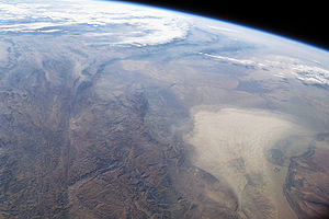
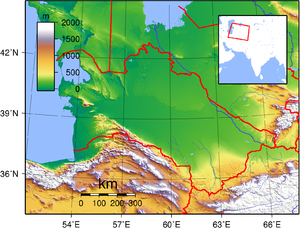
Physical features
Desert
A desert is a landscape or region that receives an extremely low amount of precipitation, less than enough to support growth of most plants. Most deserts have an average annual precipitation of less than...
with dune
Dune
In physical geography, a dune is a hill of sand built by wind. Dunes occur in different forms and sizes, formed by interaction with the wind. Most kinds of dunes are longer on the windward side where the sand is pushed up the dune and have a shorter "slip face" in the lee of the wind...
s rising to mountains in the south; low mountains along border with Iran; borders Caspian Sea
Caspian Sea
The Caspian Sea is the largest enclosed body of water on Earth by area, variously classed as the world's largest lake or a full-fledged sea. The sea has a surface area of and a volume of...
in west. Depressions along the Karakum Desert
Karakum Desert
The Karakum Desert, also spelled Kara-Kum and Gara Gum is a desert in Central Asia. It occupies about 70 percent, or 350,000 km², of the area of Turkmenistan....
may be found.
Elevation extremes:
- lowest point: Akjagaýa Depression (Sarygamysh LakeSarygamysh LakeThe Sarygamysh Lake, also Sarykamysh or Sary-Kamysh , Turkmen for 'Yellow Depression," situated in north central Turkmenistan, is geographically located approximately midway between the Caspian Sea and the Aral Sea...
) in north-western Turkmenistan, –81 m (the actual water level in Sarygamysh Lake fluctuate widely from –110 m at its shallowest to –60 m). - highest point: AýrybabaAýrybabaAýrybaba is a mountain in Central Asia. At Aýrybaba is the highest mountain in Turkmenistan. It is located in the Köýtendag Range of the Pamir-Alay chain in the southeast of Turkmenistan on the Uzbekistan border....
, 3,139 m.
Turkmenistan's average elevation is 100 to 220 meters above sea level, with its highest point being Mount Aýrybaba (3,139 m) in the Köýtendag Range of the Pamir-Alay
Pamir-Alay
The Pamir-Alay is a mountain system in Tajikistan, Kyrgyzstan and Uzbekistan, part of the Pamir Mountains. It stretches between the valleys of the rivers Syr Darya to its north and Vakhsh to its south...
chain in the south-east, and its lowest point in the Sarygamysh Lake
Sarygamysh Lake
The Sarygamysh Lake, also Sarykamysh or Sary-Kamysh , Turkmen for 'Yellow Depression," situated in north central Turkmenistan, is geographically located approximately midway between the Caspian Sea and the Aral Sea...
(close to 100 meters below sea level). The Mount Arlan rises sharply above sea level in the Great Balkhan Range in western Turkmenistan (Balkan Province
Balkan Province
Balkan Province is one of the Welayat of Turkmenistan. It is in the far west of the country, bordering Uzbekistan, Kazakhstan, the Caspian Sea, and Iran. Its capital is Balkanabat, formerly known as Nebit Dag. It has an area of 139,270 square kilometers and a population of approximately 553,500...
). Nearly 80% of the republic lies within the Turan Depression
Turan Depression
The Turan Depression, Turan Lowland or Turanian Basin is a low-lying desert basin region stretching from southern Turkmenistan through Uzbekistan to Kazakhstan. The lowland region lies to the east of the Caspian Sea and southeast of the Aral Sea in the vast Aral–Caspian Depression but extends to...
, which slopes from south to north and from east to west.
Turkmenistan's mountains include 600 km of the northern reaches of the Kopet Dag
Kopet Dag
The Kopet Dag, Kopet Dagh, or Koppeh Dagh , also known as the Turkmen-Khorasan Mountain Range is a mountain range on the frontier between Turkmenistan and Iran, extending about 650 km along the border, east of the Caspian Sea. The highest peak of the range in Turkmenistan is southwest of the...
Range, which it shares with Iran. The Kopet Dag Range is a region characterized by foothills, dry and sandy slopes, mountain plateaus, and steep ravines; Mount Şahşah (2,912 m), also known as Mount Rizeh, southwest of Ashgabat, is the highest elevation of the Kopet Dag Range in Turkmenistan. The Kopet Dag is undergoing tectonic transformation, meaning that the region is threatened by earthquake
Earthquake
An earthquake is the result of a sudden release of energy in the Earth's crust that creates seismic waves. The seismicity, seismism or seismic activity of an area refers to the frequency, type and size of earthquakes experienced over a period of time...
s such as the one that destroyed Ashgabat in 1948 and registered nine on the Richter scale
Richter magnitude scale
The expression Richter magnitude scale refers to a number of ways to assign a single number to quantify the energy contained in an earthquake....
. The Krasnovodsk and Üstýurt plateaus are the prominent topographical features of northwestern Turkmenistan.
A dominant feature of the republic's landscape is the Garagum Desert (also known as Karakum
Karakum Desert
The Karakum Desert, also spelled Kara-Kum and Gara Gum is a desert in Central Asia. It occupies about 70 percent, or 350,000 km², of the area of Turkmenistan....
), which occupies about 350,000 square kilometers (see Environmental Issues). Shifting winds create desert mountains that range from two to twenty meters in height and may be several kilometers in length. Chains of such structures are common, as are steep elevations and smooth, concrete-like clay deposits formed by the rapid evaporation of flood waters in the same area for a number of years. Large marshy salt flats, formed by capillary action in the soil, exist in many depressions, including the Garaşor, which occupies 1,500 square kilometers in the northwest. The Sandykly Desert west of the Amu Darya
Amu Darya
The Amu Darya , also called Oxus and Amu River, is a major river in Central Asia. It is formed by the junction of the Vakhsh and Panj rivers...
river is the southernmost extremity of the Qizilqum
Kyzyl Kum
The Kyzyl Kum , also called Qyzylqum, is the 11th largest desert in the world. Its name means Red Sand in Turkic languages. It is located in Central Asia in the doab between the rivers Amu Darya and Syr Darya, and is divided between Kazakhstan, Uzbekistan and Turkmenistan...
Desert, most of which lies in Uzbekistan to the northeast.
Climate
Turkmenistan has a cold desert climate that is severely continentalContinental climate
Continental climate is a climate characterized by important annual variation in temperature due to the lack of significant bodies of water nearby...
. Summers are long (from May through September), hot, and dry, while winters generally are mild and dry, although occasionally cold and damp in the north. Most precipitation falls between January and May; precipitation is slight throughout the country, with annual averages ranging from 300 millimetres (11.8 in) in the Kopet Dag
Kopet Dag
The Kopet Dag, Kopet Dagh, or Koppeh Dagh , also known as the Turkmen-Khorasan Mountain Range is a mountain range on the frontier between Turkmenistan and Iran, extending about 650 km along the border, east of the Caspian Sea. The highest peak of the range in Turkmenistan is southwest of the...
to 80 millimetres (3.15 in) in the northwest. The capital, Ashgabat, close to the Iranian border in south-central Turkmenistan, averages 225 millimetres (8.9 in) of rainfall annually. Average annual temperatures range from highs of 16.8 °C (62.2 °F) in Ashgabat to lows of -5.5 °C in Daşoguz
Dasoguz
Daşoguz , formerly known as Tashauz , is a city in northern Turkmenistan and the capital of Daşoguz Province.-Geography:...
, on the Uzbek border in north-central Turkmenistan. The almost constant winds are northerly, northeasterly, or westerly.
Hydrological conditions
Almost 80% of the territory of Turkmenistan lacks a constant source of surface water flow. Its main rivers are located only in the southern and eastern peripheries; a few smaller rivers on the northern slopes of the Kopetdag are diverted entirely to irrigation. The most important river is the Amu Darya, which has a total length of 2,540 km from its farthest tributary, making it the longest river in Central Asia. The Amu Darya flows across northeastern Turkmenistan, thence eastward to form the southern borders of Uzbekistan and TajikistanTajikistan
Tajikistan , officially the Republic of Tajikistan , is a mountainous landlocked country in Central Asia. Afghanistan borders it to the south, Uzbekistan to the west, Kyrgyzstan to the north, and China to the east....
. Damming and irrigation uses of the Amu Darya have had severe environmental effects on the Aral Sea
Aral Sea
The Aral Sea was a lake that lay between Kazakhstan in the north and Karakalpakstan, an autonomous region of Uzbekistan, in the south...
, into which the river flows (see Environmental Issues). The river's average annual flow is 1,940 cubic meters per second. Other major rivers are the Tejen (1,124 km); the Murgab
Murgab River (Afghanistan)
The Morghāb River , also transliterated as Murgab from Russian Мургаб, is an 850 km long river in Central Asia...
(852 km); and the Atrek (660 km).
Background
Since the dissolution of the Soviet UnionDissolution of the Soviet Union
The dissolution of the Soviet Union was the disintegration of the federal political structures and central government of the Union of Soviet Socialist Republics , resulting in the independence of all fifteen republics of the Soviet Union between March 11, 1990 and December 25, 1991...
, environmental regulation is largely unchanged in Turkmenistan. The new government created the Ministry of Natural Resources Use and Environmental Protection in July 1992, with departments responsible for environmental protection, protection of flora and fauna, forestry
Forestry
Forestry is the interdisciplinary profession embracing the science, art, and craft of creating, managing, using, and conserving forests and associated resources in a sustainable manner to meet desired goals, needs, and values for human benefit. Forestry is practiced in plantations and natural stands...
, hydrometeorology
Hydrometeorology
Hydrometeorology is a branch of meteorology and hydrology that studies the transfer of water and energy between the land surface and the lower atmosphere....
, and administrative planning. Like other CIS republics, Turkmenistan has established an Environmental Fund based on revenues collected from environmental fines, but the fines generally are too low to accumulate significant revenue. Thanks to the former Soviet system of game preserves and the efforts of the Society for Nature Conservation and the Academy of Sciences, flora and fauna receive some protection in the republic; however, "hard-currency hunts" by wealthy Western and Arab businesspeople already are depleting animals on preserves.
Environment - current issues
Contamination of soil and groundwater with agricultural chemicals, pesticides; salination, water-logging of soil due to poor irrigation methods; Caspian Sea pollution; diversion of a large share of the flow of the Amu Darya into irrigation contributes to that river's inability to replenish the Aral Sea; desertificationEnvironment - international agreements
party to: Biodiversity, Climate Change, Climate Change-Kyoto ProtocolKyoto Protocol
The Kyoto Protocol is a protocol to the United Nations Framework Convention on Climate Change , aimed at fighting global warming...
, Desertification, Hazardous Wastes, Ozone Layer Protection
signed, but not ratified: none of the selected agreements
Desertification
According to estimates, as a result of desertificationDesertification
Desertification is the degradation of land in drylands. Caused by a variety of factors, such as climate change and human activities, desertification is one of the most significant global environmental problems.-Definitions:...
processes and pollution, biological productivity of the ecological systems in Turkmenistan has declined by 30% to 50% in recent decades. The Karakum
Karakum Desert
The Karakum Desert, also spelled Kara-Kum and Gara Gum is a desert in Central Asia. It occupies about 70 percent, or 350,000 km², of the area of Turkmenistan....
and Kyzyl Kum
Kyzyl Kum
The Kyzyl Kum , also called Qyzylqum, is the 11th largest desert in the world. Its name means Red Sand in Turkic languages. It is located in Central Asia in the doab between the rivers Amu Darya and Syr Darya, and is divided between Kazakhstan, Uzbekistan and Turkmenistan...
deserts are expanding at a rate surpassed on a planetary scale only by the desertification process in the Sahara
Sahara
The Sahara is the world's second largest desert, after Antarctica. At over , it covers most of Northern Africa, making it almost as large as Europe or the United States. The Sahara stretches from the Red Sea, including parts of the Mediterranean coasts, to the outskirts of the Atlantic Ocean...
and Sahel
Sahel
The Sahel is the ecoclimatic and biogeographic zone of transition between the Sahara desert in the North and the Sudanian Savannas in the south.It stretches across the North African continent between the Atlantic Ocean and the Red Sea....
regions of Africa. Between 8,000 and 10,000 km² of new desert now appears each year in Central Asia.
The most irreparable type of desertification is the salinization process that forms marshy salt flats. A major factor that contributes to these conditions is inefficient use of water because of weak regulation and failure to charge for water that is used. Efficiency in application of water to the fields is low, but the main problem is leakage in main and secondary canals, especially Turkmenistan's main canal, the Karakum Canal
Qaraqum Canal
The Qaraqum Canal in Turkmenistan is one of the largest irrigation and water supply canals in the world...
. Nearly half of the canal's water seeps out into lakes and salt swamps along its path. Excessive irrigation brings salts to the surface, forming salt marshes that dry into unusable clay flats. In 1989 Turkmenistan's Institute for Desert Studies claimed that the area of such flats had reached 10,000 km².
The type of desertification caused by year-round pasturing of cattle has been termed the most devastating in Central Asia, with the gravest situations in Turkmenistan and the Kazakh steppe
Kazakhstan
Kazakhstan , officially the Republic of Kazakhstan, is a transcontinental country in Central Asia and Eastern Europe. Ranked as the ninth largest country in the world, it is also the world's largest landlocked country; its territory of is greater than Western Europe...
along the eastern and northern coasts of the Caspian Sea
Caspian Sea
The Caspian Sea is the largest enclosed body of water on Earth by area, variously classed as the world's largest lake or a full-fledged sea. The sea has a surface area of and a volume of...
. Wind erosion and desertification also are severe in settled areas along the Garagum Canal; planted windbreaks have died because of soil waterlogging and/or salinization. Other factors promoting desertification are the inadequacy of the collector-drainage system built in the 1950s and inappropriate application of chemicals.
The Aral Sea
Turkmenistan both contributes to and suffers from the consequences of the desiccation of the Aral SeaAral Sea
The Aral Sea was a lake that lay between Kazakhstan in the north and Karakalpakstan, an autonomous region of Uzbekistan, in the south...
. Because of excessive irrigation, Turkmen agriculture contributes to the steady drawdown of sea levels. In turn, the Aral Sea's desiccation
Desiccation
Desiccation is the state of extreme dryness, or the process of extreme drying. A desiccant is a hygroscopic substance that induces or sustains such a state in its local vicinity in a moderately sealed container.-Science:...
, which had shrunk that body of water by an estimated 59,000 square kilometers by 1994, profoundly affects economic productivity and the health of the population of the republic. Besides the cost of ameliorating damaged areas and the loss of at least part of the initial investment in them, salinization and chemicalization of land have reduced agricultural productivity in Central Asia by an estimated 20 to 25%. Poor drinking water is the main health risk posed by such environmental degradation. In Dashhowuz Province
Dashhowuz Province
Daşoguz Province is one of the welayat of Turkmenistan. It is in the north of the country, bordering Uzbekistan. The area of the province is 73,430 square kilometers, and the total population is 1,370,400...
, which has suffered the greatest ecological damage from the Aral Sea's desiccation, bacteria levels in drinking water exceeded ten times the sanitary level; 70% of the population has experienced illnesses, many with hepatitis
Hepatitis
Hepatitis is a medical condition defined by the inflammation of the liver and characterized by the presence of inflammatory cells in the tissue of the organ. The name is from the Greek hepar , the root being hepat- , meaning liver, and suffix -itis, meaning "inflammation"...
, and infant mortality
Infant mortality
Infant mortality is defined as the number of infant deaths per 1000 live births. Traditionally, the most common cause worldwide was dehydration from diarrhea. However, the spreading information about Oral Re-hydration Solution to mothers around the world has decreased the rate of children dying...
is high. Experts have warned that inhabitants will have to evacuate the province by the end of the century unless a comprehensive cleanup program is undertaken. Turkmenistan has announced plans to clean up some of the Aral Sea fallout with financial support from the World Bank
World Bank
The World Bank is an international financial institution that provides loans to developing countries for capital programmes.The World Bank's official goal is the reduction of poverty...
.
Chemical pollution
The most productive cottonCotton
Cotton is a soft, fluffy staple fiber that grows in a boll, or protective capsule, around the seeds of cotton plants of the genus Gossypium. The fiber is almost pure cellulose. The botanical purpose of cotton fiber is to aid in seed dispersal....
lands in Turkmenistan (the middle and lower Amu Darya and the Murgap oasis) receive as much as 250 kilograms of fertilizer per hectare, compared with the average application of thirty kilograms per hectare. Furthermore, most fertilizers are so poorly applied that experts have estimated that only 15 to 40% of the chemicals can be absorbed by cotton plants, while the remainder washes into the soil and subsequently into the groundwater. Cotton also uses far more pesticides and defoliants than other crops, and application of these chemicals often is mishandled by farmers. For example, local herdsmen, unaware of the danger of DDT, have reportedly mixed the pesticide with water and applied it to their faces to keep away mosquitoes. In the late 1980s, a drive began in Central Asia to reduce agrochemical usage. In Turkmenistan the campaign reduced fertilizer use 30% between 1988 and 1989. In the early 1990s, use of some pesticides and defoliants declined drastically because of the country's shortage of hard currency.
Area and boundaries
Area:total: 488,100 km²
land: 488,100 km²
water: 0 km²
Area - comparative: slightly larger than California
Land boundaries:
total: 3,736 km
border countries: Afghanistan
Afghanistan
Afghanistan , officially the Islamic Republic of Afghanistan, is a landlocked country located in the centre of Asia, forming South Asia, Central Asia and the Middle East. With a population of about 29 million, it has an area of , making it the 42nd most populous and 41st largest nation in the world...
744 km, Iran
Iran
Iran , officially the Islamic Republic of Iran , is a country in Southern and Western Asia. The name "Iran" has been in use natively since the Sassanian era and came into use internationally in 1935, before which the country was known to the Western world as Persia...
992 km, Kazakhstan
Kazakhstan
Kazakhstan , officially the Republic of Kazakhstan, is a transcontinental country in Central Asia and Eastern Europe. Ranked as the ninth largest country in the world, it is also the world's largest landlocked country; its territory of is greater than Western Europe...
379 km, Uzbekistan
Uzbekistan
Uzbekistan , officially the Republic of Uzbekistan is a doubly landlocked country in Central Asia and one of the six independent Turkic states. It shares borders with Kazakhstan to the west and to the north, Kyrgyzstan and Tajikistan to the east, and Afghanistan and Turkmenistan to the south....
1,621 km
Coastline: 0 km
Note: Turkmenistan borders the Caspian Sea
Caspian Sea
The Caspian Sea is the largest enclosed body of water on Earth by area, variously classed as the world's largest lake or a full-fledged sea. The sea has a surface area of and a volume of...
. Its coastline with the Caspian Sea is 1,768 km.
Maritime claims: none (landlocked)
Resources
Natural resources: petroleumPetroleum
Petroleum or crude oil is a naturally occurring, flammable liquid consisting of a complex mixture of hydrocarbons of various molecular weights and other liquid organic compounds, that are found in geologic formations beneath the Earth's surface. Petroleum is recovered mostly through oil drilling...
, natural gas
Natural gas
Natural gas is a naturally occurring gas mixture consisting primarily of methane, typically with 0–20% higher hydrocarbons . It is found associated with other hydrocarbon fuel, in coal beds, as methane clathrates, and is an important fuel source and a major feedstock for fertilizers.Most natural...
, coal
Coal
Coal is a combustible black or brownish-black sedimentary rock usually occurring in rock strata in layers or veins called coal beds or coal seams. The harder forms, such as anthracite coal, can be regarded as metamorphic rock because of later exposure to elevated temperature and pressure...
, sulfur
Sulfur
Sulfur or sulphur is the chemical element with atomic number 16. In the periodic table it is represented by the symbol S. It is an abundant, multivalent non-metal. Under normal conditions, sulfur atoms form cyclic octatomic molecules with chemical formula S8. Elemental sulfur is a bright yellow...
, salt
Salt
In chemistry, salts are ionic compounds that result from the neutralization reaction of an acid and a base. They are composed of cations and anions so that the product is electrically neutral...
Land use:
arable land: 3%
permanent crops: 0%
permanent pastures: 63%
forests and woodland: 8%
other: 26% (1993 est.)
Irrigated land: 13,000 km² (1993 est.)