

Four Corners Monument
Encyclopedia
The Four Corners Monument marks the quadripoint
in the Southwestern United States
where the states of Arizona
, Colorado
, New Mexico
and Utah
meet. It is the only point in the United States shared by four states, leading to this area being called the Four Corners region. The monument also marks the boundary between two semi-autonomous native American
governments, the Navajo Nation
, which maintains the monument as a tourist attraction, and the Ute Mountain Ute Tribe
Reservation.
The origins of the state boundaries marked by the monument occurred during the American Civil War
, when the United States Congress
acted to form governments in the area to combat Confederate
ambitions for the region. Claims are sometimes made that the monument was misplaced in the initial surveys. The accuracy of the surveys has been defended by the U.S. National Geodetic Survey
and the monument has been legally established as the corner of the four states.
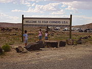
 The monument where "visitors can simultaneously straddle the territory of four states" is maintained as a tourist attraction
by the Navajo Nation Parks and Recreation Department. Unlike many other attractions based on political boundaries, such as the Berlin Wall
, it is an example of a political boundary
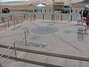
as a tourist destination for the sake of itself. The monument consists of a granite
disk embedded with a smaller bronze
disk around the point, surrounded by smaller, appropriately located state seals and flags representing both the states and tribal nations of the area. Circling the point, with two words in each state, the disk reads, "Four states here meet in freedom under God." Around the monument, local Navajo and Ute artisans sell souvenirs and food. An admission fee is required to view and photograph the monument. The monument is a popular tourist attraction despite its remote and isolated location. It has become somewhat of a phenomenon for people to travel long distances to take pictures of family and friends at the monument in Twister
-like poses, sitting on the disk, in a circle of friends or family around the disk, or for couples to kiss directly over the disk.
 The monument is located on the Colorado Plateau
west of U.S. Highway 160, approximately 40 miles (64.4 km) southwest of Cortez, Colorado
. The monument is centered at 36°59′56.31532"N 109°02′42.62019"W. In addition to the four states, two semi-autonomous
Native American tribal governments have boundaries at the monument, the Navajo Nation
and the Ute Mountain Ute Tribe
Reservation, with the Ute Mountain tribal boundaries coinciding with Colorado's boundaries at the monument.
Media reports sometimes claim that the monument was not placed in the intended location. The American Surveyor Magazine has responded to these stories claiming the boundary surveys for the New Mexico – Arizona border were accurate. They explain that the reference point used by the U.S. Congress at the time was the Washington meridian
, which has an offset from the modern reference, the Prime Meridian
. This offset is often missed by those not familiar with the history of American surveying. The geography department at the University of Oregon
teaches that this offset can be ignored to simplify estimates of distance, but the simplification results in an error of between 2.3 miles (3.7 km) and 3 miles (4.8 km). A common claim is the monument was misplaced 2.5 miles (4 km) west of the true Four Corners, within this range.
In 2009, a spokesperson for the U.S. National Geodetic Survey
admitted the monument is placed 1807 feet (550.8 m) east of where modern surveyors would mark the point. However, he defended the accuracy of the 1875 survey, stating surveyors "nailed it" considering the primitive tools of the day. Pointing out the achievement given the conditions, he further stated, "Their ability to replicate that exact point — what they did was phenomenal, what they did was spot on." He concluded by stating that any claims of errors in the location of the monument are irrelevant. Once a survey commissioned to establish a boundary has been accepted by the involved parties, the survey markers are legally binding, regardless of any error that is later discovered. Similar statements were issued by the Navajo Nation, defending their work in maintaining and promoting the monument. In addition, general U.S. land principles, law, and the Supreme Court have established that the location of the monument is the legal corner of the four states.
following its independence from Spain
, until being ceded
to the United States by the Treaty of Guadalupe Hidalgo
in 1848.
The location of the Four Corners Monument was effectively set in 1861 as the southwest corner of the Colorado Territory
by the 36th United States Congress
. Congress transferred land previously allocated to the Utah Territory
by declaring the boundary of Colorado to be the 32nd meridian west from Washington
. This line was derived from the reference used at the time, the Washington meridian
.
 In 1861, in the midst of the American Civil War
, a group of people in the southern portion of New Mexico Territory
passed a resolution condemning the United States for creating a vast territory with only a single, small government in place at Santa Fe
. They claimed by doing so the U.S. had ignored the needs of the southern portion, left them without a functional system of law and order, and allowed the situation to deteriorate into a state of chaos and near anarchy. The group declared secession from the United States and announced their intent to join the Confederate States of America
under the name of the Arizona Territory. The U.S. Congress responded in 1863 by creating another Arizona Territory
with different, but partially overlapping boundaries. The Confederate boundaries split New Mexico along an east–west line, the 34th parallel north
, allowing for a single state connection from Texas
to the Colorado River
. This would give the Confederacy access to California
and the Pacific coast
. The Union definition split New Mexico along a north–south line, extending the boundaries established for Colorado. This created the quadripoint
at the modern Four Corners – with two territories separating California from Texas. After the split, New Mexico resembled its modern form, with slight differences.
After the Civil War, efforts began to survey and create states from the earlier territories. The first survey of the line was made by E. N. Darling in 1868, and marked with a sandstone marker. Another survey was completed in 1875 by Chandler Robbins, at which time the marker was moved to its current location. The results of this survey were later accepted as the legal boundary when states were established from the earlier territories. The first permanent marker was placed at the site in 1912. The first modern Navajo government convened in 1923 in an effort to organize and regulate an increasing amount of oil exploration activities on Navajo lands. A bronze disk was placed at the spot in 1931. The Navajo Nation has since assumed the monument, pouring a concrete pad and other site improvements during the 1960s. The monument was completely rebuilt in 1992, and again in 2010.
Quadripoint
A quadripoint is a point on the Earth that touches the border of four distinct territories. The term has never been in common use—it may not have been used before 1964, by the Geographer of the United States...
in the Southwestern United States
Southwestern United States
The Southwestern United States is a region defined in different ways by different sources. Broad definitions include nearly a quarter of the United States, including Arizona, California, Colorado, Nevada, New Mexico, Oklahoma, Texas and Utah...
where the states of Arizona
Arizona
Arizona ; is a state located in the southwestern region of the United States. It is also part of the western United States and the mountain west. The capital and largest city is Phoenix...
, Colorado
Colorado
Colorado is a U.S. state that encompasses much of the Rocky Mountains as well as the northeastern portion of the Colorado Plateau and the western edge of the Great Plains...
, New Mexico
New Mexico
New Mexico is a state located in the southwest and western regions of the United States. New Mexico is also usually considered one of the Mountain States. With a population density of 16 per square mile, New Mexico is the sixth-most sparsely inhabited U.S...
and Utah
Utah
Utah is a state in the Western United States. It was the 45th state to join the Union, on January 4, 1896. Approximately 80% of Utah's 2,763,885 people live along the Wasatch Front, centering on Salt Lake City. This leaves vast expanses of the state nearly uninhabited, making the population the...
meet. It is the only point in the United States shared by four states, leading to this area being called the Four Corners region. The monument also marks the boundary between two semi-autonomous native American
Indigenous peoples of the Americas
The indigenous peoples of the Americas are the pre-Columbian inhabitants of North and South America, their descendants and other ethnic groups who are identified with those peoples. Indigenous peoples are known in Canada as Aboriginal peoples, and in the United States as Native Americans...
governments, the Navajo Nation
Navajo Nation
The Navajo Nation is a semi-autonomous Native American-governed territory covering , occupying all of northeastern Arizona, the southeastern portion of Utah, and northwestern New Mexico...
, which maintains the monument as a tourist attraction, and the Ute Mountain Ute Tribe
Ute Mountain Ute Tribe
The Ute Mountain Ute Tribe is one of three federally recognized tribes of the Ute Nation, and are mostly descendants of the historic Weeminuche Band who moved to the Southern Ute reservation in 1897...
Reservation.
The origins of the state boundaries marked by the monument occurred during the American Civil War
American Civil War
The American Civil War was a civil war fought in the United States of America. In response to the election of Abraham Lincoln as President of the United States, 11 southern slave states declared their secession from the United States and formed the Confederate States of America ; the other 25...
, when the United States Congress
United States Congress
The United States Congress is the bicameral legislature of the federal government of the United States, consisting of the Senate and the House of Representatives. The Congress meets in the United States Capitol in Washington, D.C....
acted to form governments in the area to combat Confederate
Confederate States of America
The Confederate States of America was a government set up from 1861 to 1865 by 11 Southern slave states of the United States of America that had declared their secession from the U.S...
ambitions for the region. Claims are sometimes made that the monument was misplaced in the initial surveys. The accuracy of the surveys has been defended by the U.S. National Geodetic Survey
U.S. National Geodetic Survey
National Geodetic Survey, formerly called the U.S. Coast and Geodetic Survey , is a United States federal agency that defines and manages a national coordinate system, providing the foundation for transportation and communication; mapping and charting; and a large number of applications of science...
and the monument has been legally established as the corner of the four states.
Monument
Tourist attraction
A tourist attraction is a place of interest where tourists visit, typically for its inherent or exhibited cultural value, historical significance, natural or built beauty, or amusement opportunities....
by the Navajo Nation Parks and Recreation Department. Unlike many other attractions based on political boundaries, such as the Berlin Wall
Berlin Wall
The Berlin Wall was a barrier constructed by the German Democratic Republic starting on 13 August 1961, that completely cut off West Berlin from surrounding East Germany and from East Berlin...
, it is an example of a political boundary
Border
Borders define geographic boundaries of political entities or legal jurisdictions, such as governments, sovereign states, federated states and other subnational entities. Some borders—such as a state's internal administrative borders, or inter-state borders within the Schengen Area—are open and...
as a tourist destination for the sake of itself. The monument consists of a granite
Granite
Granite is a common and widely occurring type of intrusive, felsic, igneous rock. Granite usually has a medium- to coarse-grained texture. Occasionally some individual crystals are larger than the groundmass, in which case the texture is known as porphyritic. A granitic rock with a porphyritic...
disk embedded with a smaller bronze
Bronze
Bronze is a metal alloy consisting primarily of copper, usually with tin as the main additive. It is hard and brittle, and it was particularly significant in antiquity, so much so that the Bronze Age was named after the metal...
disk around the point, surrounded by smaller, appropriately located state seals and flags representing both the states and tribal nations of the area. Circling the point, with two words in each state, the disk reads, "Four states here meet in freedom under God." Around the monument, local Navajo and Ute artisans sell souvenirs and food. An admission fee is required to view and photograph the monument. The monument is a popular tourist attraction despite its remote and isolated location. It has become somewhat of a phenomenon for people to travel long distances to take pictures of family and friends at the monument in Twister
Twister (game)
Twister is a game of physical skill produced by Hasbro Games. It is played on a large plastic mat that is spread on the floor or ground. The mat has four rows of large colored circles on it with a different color in each row: red, yellow, blue, and green. A spinner is attached to a square board...
-like poses, sitting on the disk, in a circle of friends or family around the disk, or for couples to kiss directly over the disk.
Location
Colorado Plateau
The Colorado Plateau, also called the Colorado Plateau Province, is a physiographic region of the Intermontane Plateaus, roughly centered on the Four Corners region of the southwestern United States. The province covers an area of 337,000 km2 within western Colorado, northwestern New Mexico,...
west of U.S. Highway 160, approximately 40 miles (64.4 km) southwest of Cortez, Colorado
Cortez, Colorado
The city of Cortez is a Home Rule Municipality that is the county seat and the most populous city of Montezuma County, Colorado, United States. The city population was 8,482 at the 2010 census...
. The monument is centered at 36°59′56.31532"N 109°02′42.62019"W. In addition to the four states, two semi-autonomous
Autonomy
Autonomy is a concept found in moral, political and bioethical philosophy. Within these contexts, it is the capacity of a rational individual to make an informed, un-coerced decision...
Native American tribal governments have boundaries at the monument, the Navajo Nation
Navajo Nation
The Navajo Nation is a semi-autonomous Native American-governed territory covering , occupying all of northeastern Arizona, the southeastern portion of Utah, and northwestern New Mexico...
and the Ute Mountain Ute Tribe
Ute Mountain Ute Tribe
The Ute Mountain Ute Tribe is one of three federally recognized tribes of the Ute Nation, and are mostly descendants of the historic Weeminuche Band who moved to the Southern Ute reservation in 1897...
Reservation, with the Ute Mountain tribal boundaries coinciding with Colorado's boundaries at the monument.
Media reports sometimes claim that the monument was not placed in the intended location. The American Surveyor Magazine has responded to these stories claiming the boundary surveys for the New Mexico – Arizona border were accurate. They explain that the reference point used by the U.S. Congress at the time was the Washington meridian
Washington meridian
The Washington meridian was one of four prime meridians of the United States which passed through Washington, D.C.. The four which have been specified are:# through the Capitol# through the White House# through the old Naval Observatory...
, which has an offset from the modern reference, the Prime Meridian
Prime Meridian
The Prime Meridian is the meridian at which the longitude is defined to be 0°.The Prime Meridian and its opposite the 180th meridian , which the International Date Line generally follows, form a great circle that divides the Earth into the Eastern and Western Hemispheres.An international...
. This offset is often missed by those not familiar with the history of American surveying. The geography department at the University of Oregon
University of Oregon
-Colleges and schools:The University of Oregon is organized into eight schools and colleges—six professional schools and colleges, an Arts and Sciences College and an Honors College.- School of Architecture and Allied Arts :...
teaches that this offset can be ignored to simplify estimates of distance, but the simplification results in an error of between 2.3 miles (3.7 km) and 3 miles (4.8 km). A common claim is the monument was misplaced 2.5 miles (4 km) west of the true Four Corners, within this range.
In 2009, a spokesperson for the U.S. National Geodetic Survey
U.S. National Geodetic Survey
National Geodetic Survey, formerly called the U.S. Coast and Geodetic Survey , is a United States federal agency that defines and manages a national coordinate system, providing the foundation for transportation and communication; mapping and charting; and a large number of applications of science...
admitted the monument is placed 1807 feet (550.8 m) east of where modern surveyors would mark the point. However, he defended the accuracy of the 1875 survey, stating surveyors "nailed it" considering the primitive tools of the day. Pointing out the achievement given the conditions, he further stated, "Their ability to replicate that exact point — what they did was phenomenal, what they did was spot on." He concluded by stating that any claims of errors in the location of the monument are irrelevant. Once a survey commissioned to establish a boundary has been accepted by the involved parties, the survey markers are legally binding, regardless of any error that is later discovered. Similar statements were issued by the Navajo Nation, defending their work in maintaining and promoting the monument. In addition, general U.S. land principles, law, and the Supreme Court have established that the location of the monument is the legal corner of the four states.
History
The area now called Four Corners was governed by MexicoMexico
The United Mexican States , commonly known as Mexico , is a federal constitutional republic in North America. It is bordered on the north by the United States; on the south and west by the Pacific Ocean; on the southeast by Guatemala, Belize, and the Caribbean Sea; and on the east by the Gulf of...
following its independence from Spain
Spain
Spain , officially the Kingdom of Spain languages]] under the European Charter for Regional or Minority Languages. In each of these, Spain's official name is as follows:;;;;;;), is a country and member state of the European Union located in southwestern Europe on the Iberian Peninsula...
, until being ceded
Mexican Cession
The Mexican Cession of 1848 is a historical name in the United States for the region of the present day southwestern United States that Mexico ceded to the U.S...
to the United States by the Treaty of Guadalupe Hidalgo
Treaty of Guadalupe Hidalgo
The Treaty of Guadalupe Hidalgo is the peace treaty, largely dictated by the United States to the interim government of a militarily occupied Mexico City, that ended the Mexican-American War on February 2, 1848...
in 1848.
The location of the Four Corners Monument was effectively set in 1861 as the southwest corner of the Colorado Territory
Colorado Territory
The Territory of Colorado was an organized incorporated territory of the United States that existed from February 28, 1861, until August 1, 1876, when it was admitted to the Union as the State of Colorado....
by the 36th United States Congress
36th United States Congress
The Thirty-sixth United States Congress was a meeting of the legislative branch of the United States federal government, consisting of the United States Senate and the United States House of Representatives. It met in Washington, D.C. from March 4, 1859 to March 4, 1861, during the third and fourth...
. Congress transferred land previously allocated to the Utah Territory
Utah Territory
The Territory of Utah was an organized incorporated territory of the United States that existed from September 9, 1850, until January 4, 1896, when the final extent of the territory was admitted to the Union as the State of Utah....
by declaring the boundary of Colorado to be the 32nd meridian west from Washington
32nd meridian west from Washington
The 32nd meridian of longitude west from Washington is a line of longitude approximately 109°02′48″ west of the Prime Meridian of Greenwich. In the United States of America, the meridian 32 degrees west of the Washington Meridian defines the western boundaries of the State of Colorado and the...
. This line was derived from the reference used at the time, the Washington meridian
Washington meridian
The Washington meridian was one of four prime meridians of the United States which passed through Washington, D.C.. The four which have been specified are:# through the Capitol# through the White House# through the old Naval Observatory...
.
American Civil War
The American Civil War was a civil war fought in the United States of America. In response to the election of Abraham Lincoln as President of the United States, 11 southern slave states declared their secession from the United States and formed the Confederate States of America ; the other 25...
, a group of people in the southern portion of New Mexico Territory
New Mexico Territory
thumb|right|240px|Proposed boundaries for State of New Mexico, 1850The Territory of New Mexico was an organized incorporated territory of the United States that existed from September 9, 1850, until January 6, 1912, when the final extent of the territory was admitted to the Union as the State of...
passed a resolution condemning the United States for creating a vast territory with only a single, small government in place at Santa Fe
Santa Fe, New Mexico
Santa Fe is the capital of the U.S. state of New Mexico. It is the fourth-largest city in the state and is the seat of . Santa Fe had a population of 67,947 in the 2010 census...
. They claimed by doing so the U.S. had ignored the needs of the southern portion, left them without a functional system of law and order, and allowed the situation to deteriorate into a state of chaos and near anarchy. The group declared secession from the United States and announced their intent to join the Confederate States of America
Confederate States of America
The Confederate States of America was a government set up from 1861 to 1865 by 11 Southern slave states of the United States of America that had declared their secession from the U.S...
under the name of the Arizona Territory. The U.S. Congress responded in 1863 by creating another Arizona Territory
Arizona Territory
The Territory of Arizona was an organized incorporated territory of the United States that existed from February 24, 1863 until February 14, 1912, when it was admitted to the Union as the 48th state....
with different, but partially overlapping boundaries. The Confederate boundaries split New Mexico along an east–west line, the 34th parallel north
34th parallel north
The 34th parallel north is a circle of latitude that is 34 degrees north of the Earth's equatorial plane. It crosses Africa, the Mediterranean Sea, Asia, the Pacific Ocean, North America and the Atlantic Ocean....
, allowing for a single state connection from Texas
Texas
Texas is the second largest U.S. state by both area and population, and the largest state by area in the contiguous United States.The name, based on the Caddo word "Tejas" meaning "friends" or "allies", was applied by the Spanish to the Caddo themselves and to the region of their settlement in...
to the Colorado River
Colorado River
The Colorado River , is a river in the Southwestern United States and northwestern Mexico, approximately long, draining a part of the arid regions on the western slope of the Rocky Mountains. The watershed of the Colorado River covers in parts of seven U.S. states and two Mexican states...
. This would give the Confederacy access to California
California
California is a state located on the West Coast of the United States. It is by far the most populous U.S. state, and the third-largest by land area...
and the Pacific coast
Pacific Coast
A country's Pacific coast is the part of its coast bordering the Pacific Ocean.-The Americas:Countries on the western side of the Americas have a Pacific coast as their western border.* Geography of Canada* Geography of Chile* Geography of Colombia...
. The Union definition split New Mexico along a north–south line, extending the boundaries established for Colorado. This created the quadripoint
Quadripoint
A quadripoint is a point on the Earth that touches the border of four distinct territories. The term has never been in common use—it may not have been used before 1964, by the Geographer of the United States...
at the modern Four Corners – with two territories separating California from Texas. After the split, New Mexico resembled its modern form, with slight differences.
After the Civil War, efforts began to survey and create states from the earlier territories. The first survey of the line was made by E. N. Darling in 1868, and marked with a sandstone marker. Another survey was completed in 1875 by Chandler Robbins, at which time the marker was moved to its current location. The results of this survey were later accepted as the legal boundary when states were established from the earlier territories. The first permanent marker was placed at the site in 1912. The first modern Navajo government convened in 1923 in an effort to organize and regulate an increasing amount of oil exploration activities on Navajo lands. A bronze disk was placed at the spot in 1931. The Navajo Nation has since assumed the monument, pouring a concrete pad and other site improvements during the 1960s. The monument was completely rebuilt in 1992, and again in 2010.
See also
- 37th parallel north37th parallel northThe 37th parallel north is a circle of latitude that is 37 degrees north of the Earth's equatorial plane. It crosses Europe, the Mediterranean Sea, Africa, Asia, the Pacific Ocean, North America, and the Atlantic Ocean....
– Congressionally defined southern border of Colorado - New Mexico State Road 597New Mexico State Road 597State Road 597 is a long state highway located entirely in the Navajo Nation, which is located in San Juan County, New Mexico, United States. The highway serves to link the U.S. Route 160 to the Four Corners Monument...
– Highway used to access the monument
Similar places
- Citrus Ridge, FloridaCitrus Ridge, FloridaCitrus Ridge, often called Four Corners, is a census-designated place in the U.S. state of Florida, located at a quadripoint formed by Lake, Orange, Osceola and Polk Counties. U.S. Routes 27 and 192 serve the area. The population was 12,015 at the 2000 census...
- No Man's HeathNo Man's Heath (four counties)No Man's Heath is an area six miles north-east of Tamworth, Staffordshire. Its name indicates that it is on high heathland near the borders of four English counties: Derbyshire, Leicestershire, Warwickshire and Staffordshire. The place is probably a highpoint on an ancient road, either Roman or...
- Tres FronterasTres FronterasTres Fronteras is the Spanish name for an area of the Amazon Rainforest, noted for its natural beauty, where Brazil, Peru, and Colombia meet...
- Triple FrontierTriple FrontierThe Triple Frontier is a tri-border area along the junction of Paraguay, Argentina, and Brazil, where the Iguazú and Paraná rivers converge. Near the convergence are the cities of Ciudad del Este, Alto Paraná; Puerto Iguazú, Misiones and Foz do Iguaçu, Paraná...
- TreriksrösetTreriksrösetTreriksröset , Treriksrøysa , Kolmen valtakunnan rajapyykki is the point at which the borders of Sweden, Norway and Finland meet....
- VaalserbergVaalserbergThe Vaalserberg is a hill 322.7 metres in height and the highest point in the European part of the Netherlands. The Vaalserberg is located in the province of Limburg, at the south-easternmost edge of the country in the municipality of Vaals, near the eponymous town, some three kilometres west of...
External links
- Official site – Navajo Parks and Recreation
- NGS Survey Information
- Geocaching Recovery Logs