
New Mexico State Road 597
Encyclopedia
State highway
State highway, state road or state route can refer to one of three related concepts, two of them related to a state or provincial government in a country that is divided into states or provinces :#A...
located entirely in the Navajo Nation
Navajo Nation
The Navajo Nation is a semi-autonomous Native American-governed territory covering , occupying all of northeastern Arizona, the southeastern portion of Utah, and northwestern New Mexico...
, which is located in San Juan County
San Juan County, New Mexico
-2010:Whereas according to the 2010 U.S. Census Bureau:*51.6% White*0.6% Black*36.6% Native American*0.4% Asian*0.1% Native Hawaiian or Pacific Islander*3.5% Two or more races*7.2% Other races*19.1% Hispanic or Latino -2000:...
, New Mexico
New Mexico
New Mexico is a state located in the southwest and western regions of the United States. New Mexico is also usually considered one of the Mountain States. With a population density of 16 per square mile, New Mexico is the sixth-most sparsely inhabited U.S...
, United States. The highway serves to link the U.S. Route 160 (US 160) to the Four Corners Monument
Four Corners Monument
The Four Corners Monument marks the quadripoint in the Southwestern United States where the states of Arizona, Colorado, New Mexico and Utah meet. It is the only point in the United States shared by four states, leading to this area being called the Four Corners region...
. The highway is the second shortest highway in New Mexico, with the shortest being NM 446 measuring 0.25 miles (402.3 m).
Route description
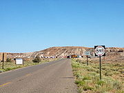
NM 597 begins at a t-intersection with US 160 in extreme northwestern San Juan County, New Mexico. Traveling northwest the two-lane highway passes through desert terrain to its northern terminus at a toll booth. After passing the toll booth, the road becomes 4 Corners Road, which encircles the Four Corners MonumentFour Corners Monument
The Four Corners Monument marks the quadripoint in the Southwestern United States where the states of Arizona, Colorado, New Mexico and Utah meet. It is the only point in the United States shared by four states, leading to this area being called the Four Corners region...
. The highways posted speed limit is 15 miles per hour (6.7 m/s).
The highway is the second shortest highway in New Mexico, with the shortest being NM 446 measuring 0.25 miles (402.3 m).
Major intersections
The entire route is located in San Juan CountySan Juan County, New Mexico
-2010:Whereas according to the 2010 U.S. Census Bureau:*51.6% White*0.6% Black*36.6% Native American*0.4% Asian*0.1% Native Hawaiian or Pacific Islander*3.5% Two or more races*7.2% Other races*19.1% Hispanic or Latino -2000:...
.
| Mile | Destinations | Notes |
|---|---|---|
| 0.000 | Southern terminus | |
| 0.447 | 4 Corners Road | Northern terminus, Four Corners Monument Four Corners Monument The Four Corners Monument marks the quadripoint in the Southwestern United States where the states of Arizona, Colorado, New Mexico and Utah meet. It is the only point in the United States shared by four states, leading to this area being called the Four Corners region... |