

Foreland basin
Encyclopedia
Depression (geology)
A depression in geology is a landform sunken or depressed below the surrounding area. Depressions may be formed by various mechanisms.Structural or tectonic related:...
that develops adjacent and parallel to a mountain belt
Mountain range
A mountain range is a single, large mass consisting of a succession of mountains or narrowly spaced mountain ridges, with or without peaks, closely related in position, direction, formation, and age; a component part of a mountain system or of a mountain chain...
. Foreland basins form because the immense mass created by crust
Crust (geology)
In geology, the crust is the outermost solid shell of a rocky planet or natural satellite, which is chemically distinct from the underlying mantle...
al thickening associated with the evolution of a mountain belt causes the lithosphere
Lithosphere
The lithosphere is the rigid outermost shell of a rocky planet. On Earth, it comprises the crust and the portion of the upper mantle that behaves elastically on time scales of thousands of years or greater.- Earth's lithosphere :...
to bend, by a process known as lithospheric flexure. The width and depth of the foreland basin is determined by the flexural rigidity of the underlying lithosphere, and the characteristics of the mountain belt. The foreland basin receives sediment
Sediment
Sediment is naturally occurring material that is broken down by processes of weathering and erosion, and is subsequently transported by the action of fluids such as wind, water, or ice, and/or by the force of gravity acting on the particle itself....
that is eroded off the adjacent mountain belt, filling with thick sedimentary successions that thin away from the mountain belt. Foreland basins represent an endmember basin type, the other being rift basins. Space for sediments, accommodation space, is provided by loading and downflexure to form foreland basins, in contrast to rift
Rift
In geology, a rift or chasm is a place where the Earth's crust and lithosphere are being pulled apart and is an example of extensional tectonics....
basins, where accommodation space is generated by lithospheric extension.
Types of foreland basin
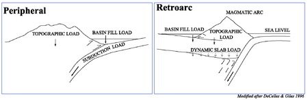
- Peripheral (Pro) foreland basins, which occur on the plate that is subducted or underthrust during plate collision (i.e. the outer arc of the orogen)
- Examples include the North Alpine Foreland Basin of Europe, or the Ganges Basin of Asia
- Retroarc (Retro) foreland basins, which occur on the plate that overrides during plate convergence or collision (i.e. situated behind the magmatic arc that is linked with the subduction of oceanic lithosphere)
- Examples include the Andean basins, or Late Mesozoic to Cenozoic Rocky Mountain Basins of North America
Foreland basin system
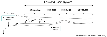
- An elongate region of potential sediment accommodation that forms on continental crust between a contractional orogenic belt and the adjacent craton, mainly in response to geodynamic processes related to subduction and the resulting peripheral or retroarc fold-thrust belt;
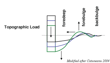
- It consists of four discrete depozones, referred to as the wedge-top, foredeep, forebulge and back-bulge depozones (depositional zones) – which of these depozones a sediment particle occupies depends on its location at the time of deposition, rather than its ultimate geometric relationship with the thrust belt;
- The longitudinal dimension of the foreland basin system is roughly equal to the length of the fold-thrust belt, and does not include sediment that spills into remnant ocean basins or continental rifts (impactogens).
Foreland basin systems: depozones
The wedge-top sits on top of the moving thrust sheets and contains all the sediments charging from the active tectonic thrust wedge.The foredeep is the thickest sedimentary zone and thickens toward the orogen. Sediments are deposited via distal fluvial, lacustrine, deltaic, and marine depositional systems.
The forebulge and backbulge are the thinnest and most distal zones and are not always present. When present, they are defined by regional unconformities as well as aeolian and shallow-marine deposits.
Sedimentation is most rapid near the moving thrust sheet. Sediment transport
Sediment transport
Sediment transport is the movement of solid particles , typically due to a combination of the force of gravity acting on the sediment, and/or the movement of the fluid in which the sediment is entrained...
within the foredeep is generally parallel to the strike of the thrust fault and basin axis.
Plate motion and seismicity
The motion of the adjacent plates of the foreland basin can be determined by studying the active deformation zone with which it is connected. Today GPS measurements provide the rate at which one plate is moving relative to another. It is also important to consider that present day kinematics are unlikely to be the same as when deformation began. Thus, it is crucial to consider non-GPS models to determine the long-term evolution of continental collisions and in how it helped develop the adjacent foreland basins.Comparing both modern GPS (Sella et al. 2002) and non-GPS models allows deformation rates to be calculated. Comparing these numbers to the geologic regime helps constrain the number of probable models as well as which model is more geologically accurate within a specific region.
Seismicity determines where active zones of seismic activity occur as well as measure the total fault displacements and the timing of the onset of deformation (Allen et al. 2004).
Formation of basins
Isostasy
Isostasy is a term used in geology to refer to the state of gravitational equilibrium between the earth's lithosphere and asthenosphere such that the tectonic plates "float" at an elevation which depends on their thickness and density. This concept is invoked to explain how different topographic...
at the upflex of the forebulge.
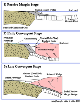
The plate tectonic evolution of a peripheral foreland basin involves three general stages. First, the passive margin stage with orogenic loading of previously stretched continental margin during the early stages of convergence. Second, the "early convergnece stage defined by deep water conditions", and lastly a "later convergent stage during which a subaerial
Subaerial
The term subaerial is mainly used in geology to describe events or structures that are located at the Earth's surface...
wedge is flanked with terrestrial or shallow marine foreland basins" (Allen & Allen 2005).
The temperature underneath the orogen is much higher and weakens the lithosphere. Thus, the thrust belt is mobile and the foreland basin system becomes deformed over time. Syntectonic unconformities demonstrate simultaneous subsidence and tectonic activity.
Foreland basins are filled with sediments which erode from the adjacent mountain belt. In the early stages, the foreland basin is said to be underfilled. During this stage, deep water and commonly marine sediments, known as flysch
Flysch
Flysch is a sequence of sedimentary rocks that is deposited in a deep marine facies in the foreland basin of a developing orogen. Flysch is typically deposited during an early stage of the orogenesis. When the orogen evolves the foreland basin becomes shallower and molasse is deposited on top of...
, are deposited. Eventually, the basin becomes completely filled. At this point, the basin enters the overfilled stage and deposition of terrestrial clastic sediments occurs. These are known as molasse
Molasse
The term "molasse" refers to the sandstones, shales and conglomerates formed as terrestrial or shallow marine deposits in front of rising mountain chains. The molasse is deposited in a foreland basin, especially on top of flysch, for example that left from the rising Alps, or erosion in the Himalaya...
. Sediment fill within the foredeep acts as an additional load on the continental lithosphere.
Lithospheric behavior
Rheology
Rheology is the study of the flow of matter, primarily in the liquid state, but also as 'soft solids' or solids under conditions in which they respond with plastic flow rather than deforming elastically in response to an applied force....
to describe the lithospheric deformation of the foreland basin. Allen & Allen (2005) describe a moving load system, one in which the deflection moves as a wave through the foreland plate before the load system. The deflection shape is commonly described as an asymmetrical low close to the load along the foreland and a broader uplifted deflection along the forebulge. The transport rate or flux of erosion, as well as sedimentation, is a function of topographic relief.
For the loading model, the lithosphere is initially stiff, with the basin broad and shallow. Relaxation of the lithosphere allows subsidence near the thrust, narrowing of basin, forebulge toward thrust. During times of thrusting, the lithosphere is stiff and the forebulge broadens. The timing of the thrust deformation is opposite that of the relaxing of the lithosphere. The bending of the lithosphere under the orogenic load controls the drainage pattern of the foreland basin. The flexural tilting of the basin and the sediment supply from the orogen.
Lithospheric strength envelopes
Strength envelopes indicate that the rheological structure of the lithosphere underneath the foreland and the orogen are very different. The foreland basin typically shows a thermal and rheological structure similar to a rifted continental margin with three brittle layers above three ductile layers. The temperature underneath the orogen is much higher and thus greatly weakens the lithosphere. According to Zhou et al. (2003), “under compressional stress the lithosphere beneath the mountain range becomes ductile almost entirely, except a thin (about 6 km in the center) brittle layer near the surface and perhaps a thin brittle layer in the uppermost mantle.” This lithospheric weakening underneath the orogenic belt may in part cause the regional lithospheric flexure behavior.Thermal history
Foreland basins are considered to be hypothermal basins (cooler than normal), with low geothermal gradientGeothermal gradient
Geothermal gradient is the rate of increasing temperature with respect to increasing depth in the Earth's interior. Away from tectonic plate boundaries, it is 25–30°C per km of depth in most of the world. Strictly speaking, geo-thermal necessarily refers to the Earth but the concept may be applied...
and heat flow. Heat flow values average between 1 and 2 HFU (40-90 mWm-2 (Allen & Allen 2005). Rapid subsidence may be responsible for these low values.
Over time sedimentary layers become buried and lose porosity. This can be due to sediment compaction
Compaction (geology)
Compaction refers to the process by which a sediment progressively loses its porosity due to the effects of loading. This forms part of the process of lithification. When a layer of sediment is originally deposited, it contains an open framework of particles with the pore space being usually...
or the physical or chemical changes, such as pressure or cementation
Cementation (geology)
Cementation involves ions carried in groundwater chemically precipitating to form new crystalline material within sediment pores; this is how "sediment" becomes "rock". The new pore-filling minerals form "bridges" between original sediment grains, thereby binding them together. So sand becomes...
. Thermal maturation of sediments is a factor of temperature and time and occurs at shallower depths due to past heat redistribution of migrating brines.
Vitrinite reflectance, which typically demonstrates an exponential evolution of organic matter as a function of time, is the best organic indicator for thermal maturation. Studies have shown that present day thermal measurements of heat flow and geothermal gradients closely correspond to a regime’s tectonic origin and development as well as the lithospheric mechanics (Allen & Allen 2005).
Fluid migration
Migrating fluids originate from the sediments of the foreland basin and migrate in response to deformation. As a result, brine can migrate over great distances. Evidence of long-range migration includes: 1) Correlation of petroleum to distant source rockSource rock
In petroleum geology, source rock refers to rocks from which hydrocarbons have been generated or are capable of being generated. They form one of the necessary elements of a working petroleum system. They are organic-rich sediments that may have been deposited in a variety of environments including...
s 2) Ore bodies deposited from metal-bearing brines, 3) Anomalous thermal histories for shallow sediments, 4) Regional potassium metasomatism, 5) Epigenetic dolomite cements in ore bodies and deep aquifers (Bethke & Marshak 1990).
Fluid source
Fluids carrying heat, minerals, and petroleum, have a vast impact on the tectonic regime within the foreland basin. Before deformation, sediment layers are porous and full of fluids, such as water and hydrated minerals. Once these sediments are buried and compacted, the pores become smaller and some of the fluids, about 1/3, leave the pores. This fluid has to go somewhere. Within the foreland basin, these fluids potentially can heat and mineralize materials, as well as mix with the local hydrostatic head.Major driving force for fluid migration
Orogen topography is the major driving force of fluid migration. The heat from the lower crust moves via conduction and groundwater advectionAdvection
Advection, in chemistry, engineering and earth sciences, is a transport mechanism of a substance, or a conserved property, by a fluid, due to the fluid's bulk motion in a particular direction. An example of advection is the transport of pollutants or silt in a river. The motion of the water carries...
. Local hydrothermal areas occur when deep fluid flow moves very quickly. This can also explain very high temperatures at shallow depths.
Other minor constraints include tectonic compression, thrusting, and sediment compaction. These are considered minor because they are limited by the slow rates of tectonic deformation, lithology
Lithology
The lithology of a rock unit is a description of its physical characteristics visible at outcrop, in hand or core samples or with low magnification microscopy, such as colour, texture, grain size, or composition. It may be either a detailed description of these characteristics or be a summary of...
and depositional rates, on the order of 0-10 cm yr-1, but more likely closer to 1 or less than 1 cm yr-1. Overpressured zones might allow for faster migration, when 1 kilometer or more of shaly sediments accumulate per 1 million years (Bethke & Marshak 1990).
Bethke & Marshak (1990) state that “groundwater that recharges at high elevation migrates through the subsurface in response to its high potential energy toward areas where the water table is lower.”
Hydrocarbon migration
Bethke & Marshak (1990) explain that petroleum migrates not only in response to the hydrodynamic forces that drive groundwater flow, but to the buoyancy and capillary effects of the petroleum moving through microscopic pores. Migration patterns flow away from the orogenic belt and into the cratonic interior. Frequently, natural gas is found closer to the orogen and oil is found further away (Oliver 1986).Europe
- North Alpine Basin
- Peripheral foreland basin to the north of the AlpsAlpsThe Alps is one of the great mountain range systems of Europe, stretching from Austria and Slovenia in the east through Italy, Switzerland, Liechtenstein and Germany to France in the west....
, in AustriaAustriaAustria , officially the Republic of Austria , is a landlocked country of roughly 8.4 million people in Central Europe. It is bordered by the Czech Republic and Germany to the north, Slovakia and Hungary to the east, Slovenia and Italy to the south, and Switzerland and Liechtenstein to the...
, SwitzerlandSwitzerlandSwitzerland name of one of the Swiss cantons. ; ; ; or ), in its full name the Swiss Confederation , is a federal republic consisting of 26 cantons, with Bern as the seat of the federal authorities. The country is situated in Western Europe,Or Central Europe depending on the definition....
, GermanyGermanyGermany , officially the Federal Republic of Germany , is a federal parliamentary republic in Europe. The country consists of 16 states while the capital and largest city is Berlin. Germany covers an area of 357,021 km2 and has a largely temperate seasonal climate...
and FranceFranceThe French Republic , The French Republic , The French Republic , (commonly known as France , is a unitary semi-presidential republic in Western Europe with several overseas territories and islands located on other continents and in the Indian, Pacific, and Atlantic oceans. Metropolitan France... - Formed during the CenozoicCenozoicThe Cenozoic era is the current and most recent of the three Phanerozoic geological eras and covers the period from 65.5 mya to the present. The era began in the wake of the Cretaceous–Tertiary extinction event at the end of the Cretaceous that saw the demise of the last non-avian dinosaurs and...
collision of Eurasia and Africa - Complications arise in the formation of the Rhine Graben
- Peripheral foreland basin to the north of the Alps
- Po Basin
- Retro-foreland basin to the south of the AlpsAlpsThe Alps is one of the great mountain range systems of Europe, stretching from Austria and Slovenia in the east through Italy, Switzerland, Liechtenstein and Germany to France in the west....
, in northern ItalyItalyItaly , officially the Italian Republic languages]] under the European Charter for Regional or Minority Languages. In each of these, Italy's official name is as follows:;;;;;;;;), is a unitary parliamentary republic in South-Central Europe. To the north it borders France, Switzerland, Austria and...
- Retro-foreland basin to the south of the Alps
- Ebro Basin
- Peripheral foreland basin to the south of the PyreneesPyreneesThe Pyrenees is a range of mountains in southwest Europe that forms a natural border between France and Spain...
, in northern SpainSpainSpain , officially the Kingdom of Spain languages]] under the European Charter for Regional or Minority Languages. In each of these, Spain's official name is as follows:;;;;;;), is a country and member state of the European Union located in southwestern Europe on the Iberian Peninsula... - Substantial deformation of the foreland basin has occurred in the north, exemplified by the foreland fold-thrust belt in the western CatalanCataloniaCatalonia is an autonomous community in northeastern Spain, with the official status of a "nationality" of Spain. Catalonia comprises four provinces: Barcelona, Girona, Lleida, and Tarragona. Its capital and largest city is Barcelona. Catalonia covers an area of 32,114 km² and has an...
province. The basin is well known for the spectacular exposures of syn- and post-tectonic sediment strata due to the peculiar drainage evolution of the basin.
- Peripheral foreland basin to the south of the Pyrenees
- Guadalquivir Basin
- Formed during the Neogene north of the Betic Cordillera (southern SpainSpainSpain , officially the Kingdom of Spain languages]] under the European Charter for Regional or Minority Languages. In each of these, Spain's official name is as follows:;;;;;;), is a country and member state of the European Union located in southwestern Europe on the Iberian Peninsula...
), on a Hercynian basement.
- Formed during the Neogene north of the Betic Cordillera (southern Spain
- Aquitaine Basin
- Retro-foreland basin to the north of the PyreneesPyreneesThe Pyrenees is a range of mountains in southwest Europe that forms a natural border between France and Spain...
, in southern FranceFranceThe French Republic , The French Republic , The French Republic , (commonly known as France , is a unitary semi-presidential republic in Western Europe with several overseas territories and islands located on other continents and in the Indian, Pacific, and Atlantic oceans. Metropolitan France...
- Retro-foreland basin to the north of the Pyrenees
Asia
- Ganges Basin
- Pro-foreland to the south of the Himalaya, in northern IndiaIndiaIndia , officially the Republic of India , is a country in South Asia. It is the seventh-largest country by geographical area, the second-most populous country with over 1.2 billion people, and the most populous democracy in the world...
and PakistanPakistanPakistan , officially the Islamic Republic of Pakistan is a sovereign state in South Asia. It has a coastline along the Arabian Sea and the Gulf of Oman in the south and is bordered by Afghanistan and Iran in the west, India in the east and China in the far northeast. In the north, Tajikistan... - Began to form 65 million years ago during the collision of India and Eurasia
- Filled with a sedimentary succession more than 12 km thick
- Pro-foreland to the south of the Himalaya, in northern India
- Northern Tarim BasinTarim BasinThe Tarim Basin is a large endorheic basin occupying an area of about . It is located in the Xinjiang Uyghur Autonomous Region in China's far west. Its northern boundary is the Tian Shan mountain range and its southern is the Kunlun Mountains on the northern edge of the Tibetan Plateau. The...
- Pro-foreland to the south of the Tien Shan
- Formed initially during the Late PaleozoicPaleozoicThe Paleozoic era is the earliest of three geologic eras of the Phanerozoic eon, spanning from roughly...
, during the CarboniferousCarboniferousThe Carboniferous is a geologic period and system that extends from the end of the Devonian Period, about 359.2 ± 2.5 Mya , to the beginning of the Permian Period, about 299.0 ± 0.8 Mya . The name is derived from the Latin word for coal, carbo. Carboniferous means "coal-bearing"...
and DevonianDevonianThe Devonian is a geologic period and system of the Paleozoic Era spanning from the end of the Silurian Period, about 416.0 ± 2.8 Mya , to the beginning of the Carboniferous Period, about 359.2 ± 2.5 Mya... - Rejuvenated during the CenozoicCenozoicThe Cenozoic era is the current and most recent of the three Phanerozoic geological eras and covers the period from 65.5 mya to the present. The era began in the wake of the Cretaceous–Tertiary extinction event at the end of the Cretaceous that saw the demise of the last non-avian dinosaurs and...
as a result of far field stress associated with the India-Eurasia collision and the renewed uplift of the Tien Shan - Thickest sedimentary section is beneath KashgarKashgarKashgar or Kashi is an oasis city with approximately 350,000 residents in the western part of the Xinjiang Uyghur Autonomous Region of the People's Republic of China. Kashgar is the administrative centre of Kashgar Prefecture which has an area of 162,000 km² and a population of approximately...
, where CenozoicCenozoicThe Cenozoic era is the current and most recent of the three Phanerozoic geological eras and covers the period from 65.5 mya to the present. The era began in the wake of the Cretaceous–Tertiary extinction event at the end of the Cretaceous that saw the demise of the last non-avian dinosaurs and...
sediment is more than 10,000 metres thick
- Southern Junggar Basin
- Retro-foreland to the north of the Tien Shan
- Formed initially during the Late PaleozoicPaleozoicThe Paleozoic era is the earliest of three geologic eras of the Phanerozoic eon, spanning from roughly...
and rejuvenated during the CenozoicCenozoicThe Cenozoic era is the current and most recent of the three Phanerozoic geological eras and covers the period from 65.5 mya to the present. The era began in the wake of the Cretaceous–Tertiary extinction event at the end of the Cretaceous that saw the demise of the last non-avian dinosaurs and... - Thickest sedimentary section is west of UrumqiÜrümqiÜrümqi , formerly Tihwa , is the capital of Xinjiang Uyghur Autonomous Region of the People's Republic of China, in the northwest of the country....
, where MesozoicMesozoicThe Mesozoic era is an interval of geological time from about 250 million years ago to about 65 million years ago. It is often referred to as the age of reptiles because reptiles, namely dinosaurs, were the dominant terrestrial and marine vertebrates of the time...
sediment is more than 8,000 metres thick
Middle East
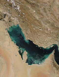
- Persian Gulf
- Foreland to the west of the Zagros mountains
- Underfilled stage
- Terrestrial part of the basin covers parts of Iraq and Kuwait
North America
- Western Canadian Sedimentary BasinWestern Canadian Sedimentary BasinThe Western Canadian Sedimentary Basin is a vast sedimentary basin underlying of Western Canada including southwestern Manitoba, southern Saskatchewan, Alberta, northeastern British Columbia and the southwest corner of the Northwest Territories. It consists of a massive wedge of sedimentary rock...
- Foreland to the east of the Rocky Mountains, AlbertaAlbertaAlberta is a province of Canada. It had an estimated population of 3.7 million in 2010 making it the most populous of Canada's three prairie provinces...
- Foreland to the east of the Rocky Mountains, Alberta
South America
- Chilean Intermediate DepressionChilean Central ValleyThe Central Valley , Intermediate Depression or Longitudinal Valley is the depression between the Chilean Costal Range and the Andes Mountains. The central valley should not be confused with Central Chile that encompasses part of the valley...
- Foreland to the west of the Andes, ChileChileChile ,officially the Republic of Chile , is a country in South America occupying a long, narrow coastal strip between the Andes mountains to the east and the Pacific Ocean to the west. It borders Peru to the north, Bolivia to the northeast, Argentina to the east, and the Drake Passage in the far...
- Foreland to the west of the Andes, Chile
Europe
- Windermere Supergroup
- Foreland basin caused by subduction of Iapetus oceanIapetus OceanThe Iapetus Ocean was an ocean that existed in the Neoproterozoic and Paleozoic eras of the geologic timescale . The Iapetus Ocean was situated in the southern hemisphere, between the paleocontinents of Laurentia, Baltica and Avalonia...
under AvaloniaAvaloniaAvalonia was a microcontinent in the Paleozoic era. Crustal fragments of this former microcontinent underlie south-west Great Britain, and the eastern coast of North America. It is the source of many of the older rocks of Western Europe, Atlantic Canada, and parts of the coastal United States... - Ordovician to Silurian in age
- Underlies most of England
- Foreland basin caused by subduction of Iapetus ocean
Asia
- Longmen Shan Basin
- Foreland to the east of the Longmen Shan mountains
- Peak evolution during the TriassicTriassicThe Triassic is a geologic period and system that extends from about 250 to 200 Mya . As the first period of the Mesozoic Era, the Triassic follows the Permian and is followed by the Jurassic. Both the start and end of the Triassic are marked by major extinction events...
to JurassicJurassicThe Jurassic is a geologic period and system that extends from about Mya to Mya, that is, from the end of the Triassic to the beginning of the Cretaceous. The Jurassic constitutes the middle period of the Mesozoic era, also known as the age of reptiles. The start of the period is marked by...
- Urals Foreland
- Foreland to the west of the Ural MountainsUral MountainsThe Ural Mountains , or simply the Urals, are a mountain range that runs approximately from north to south through western Russia, from the coast of the Arctic Ocean to the Ural River and northwestern Kazakhstan. Their eastern side is usually considered the natural boundary between Europe and Asia...
, in RussiaRussiaRussia or , officially known as both Russia and the Russian Federation , is a country in northern Eurasia. It is a federal semi-presidential republic, comprising 83 federal subjects... - Formed during the PaleozoicPaleozoicThe Paleozoic era is the earliest of three geologic eras of the Phanerozoic eon, spanning from roughly...
- Foreland to the west of the Ural Mountains
North America
- Western Interior Basin
- Foreland to the east of the Sevier orogenic belt
- Covered much of Central and Eastern UtahUtahUtah is a state in the Western United States. It was the 45th state to join the Union, on January 4, 1896. Approximately 80% of Utah's 2,763,885 people live along the Wasatch Front, centering on Salt Lake City. This leaves vast expanses of the state nearly uninhabited, making the population the...
- Evolved during the CretaceousCretaceousThe Cretaceous , derived from the Latin "creta" , usually abbreviated K for its German translation Kreide , is a geologic period and system from circa to million years ago. In the geologic timescale, the Cretaceous follows the Jurassic period and is followed by the Paleogene period of the...
- Deepest parts of the basin filled with the Mancos Shale
- Appalachian Basin
- Foreland to the west of the Appalachian mountains, in Eastern USA
- Bend Arch - Fort Worth Basin
- Pro-Foreland to the east of the OuachitaOuachitaOuachita may refer to:In geography:* Ouachita Mountains* Ouachita orogeny the geologic event that raised the Ouachita Mountains* Ouachita River* Ouachita Parish, Louisiana* Ouachita County, Arkansas* Ouachita National Forest...
orogenic belt - Formed during the PaleozoicPaleozoicThe Paleozoic era is the earliest of three geologic eras of the Phanerozoic eon, spanning from roughly...
- Pro-Foreland to the east of the Ouachita