

Five Dock, New South Wales
Encyclopedia
Five Dock is a suburb
in the inner-west
of Sydney
, in the state of New South Wales
, Australia
. Five Dock is located 10 kilometres west of the Sydney central business district
, in the Local Government Area of the City of Canada Bay
.
peninsula. More precisely, Five Dock lies between Parramatta Road
and the City West Link Road
to the south and Hen and Chicken Bay
, on the Parramatta River
, along with the suburbs of Wareemba
and Russell Lea
, to the north. Its total area is 2.45 km².
Rodd Point
lies to the east. Haberfield
adjoins Five Dock to the south-east. Iron Cove
forms a small section of the suburb's eastern boundary. Ashfield
and Croydon
lie on the other side of Parramatta Road
, to the south. The suburbs of Canada Bay
and Concord
adjoin Five Dock's western boundary. Burwood
lies just beyond Croydon, to the south-west.
From the heart of the shopping centre, it is approximately 7.5 kilometres to Sydney's central business district
, measured in a straight line from the original Sydney General Post Office
in Martin Place
. By road, this same distance is about 9-10 kilometres, depending on the route taken.
Originally, the local post office was called the "Wareemba Locality store", but after the geographical location was changed it was the named to the "Wareemba Post Office"
area remains today. It is thought that Parramatta Road
was gradually constructed over an old Aboriginal pathway, although nothing is left of this. It is known however, that prior to the arrival of the First Fleet
in Port Jackson
in 1788, the Sydney
area was home to indigenous Australians
from the Eora
group. The word Eora means simply 'the people' and the Eora were divided up into smaller tribes. Eight of these smaller groups have been identified as living along the banks of the Parramatta River
. One of these groups, the Wangal (sometimes spelt Wanngal, Wann-gal or Wanegal) people, inhabited a large area on the southern side of the Parramatta River
, stretching roughly from Sydney Cove
in the east to somewhere around Rosehill
in the west. It is believed that Woollarawarre Bennelong
was a member of the Wangal clan.
The mangrove-lined shores of the Parramatta River
were once an abundant source of food for the Wangal and the indigenous diet included Sydney cockles, Sydney rock oyster
s, Hairy mussels and Hercules club whelks. The remains of these meals, known as shell middens
, can be seen in several areas, including Rodd Park in the neighbouring suburb of Rodd Point
and at Cabarita Park in nearby Cabarita
. When the Europeans arrived, these shell middens could be found virtually all along the shores of Sydney Harbour. However, the European settlers used the materials in the middens to make lime for building mortar. As a result of this and of building activity along the foreshores, there are very few middens surviving today.
It is believed that the first contact by Europeans with the Wangal clan may have occurred on 5 February 1788 during an exploration of the Parramatta River
, which was led by Captain John Hunter. This meeting, (which may be apocryphal), is recalled in the name of the suburb Breakfast Point
, as it took place while Hunter was having breakfast.
Governor Phillip's
notes suggest that an outbreak of smallpox in early 1789 would have had a devastating impact on the indigenous population
in Canada Bay
. Phillip not only recorded that half of the local aboriginal population was estimated to have died from the disease, but he also noted that the Aboriginal people always "retired from where the diseases appeared". The Wangal people are today remembered in local names such the Wangal Bushland Reserve in Mortlake
, Wangal Place in Five Dock and the suburb Wareemba
.
. It appears that the names Five Docks and Five Dock were initially used interchangeably with the latter eventually became the accepted name.
According to a publication from the Maritime Services Board, Port of Sydney, (Volume 9, No 3, September 1965), "At the NE point of the bay there were five water worn indentations that were likened to docks, hence the name Five Dock." http://www.gnb.nsw.gov.au/name_search/extract?id=JPQlXtqban. There is widely contradictory information, however, about how many of these natural formations still exist. The Maritime Services Board publication concludes that there "are two of the five remaining". However, Eric Russell's Drummoyne: a western suburbs' history from 1794 states that one was lost with the construction of the 1881 Gladesville Bridge
, but "the others remain in 1982". Other sources give different numbers again. According to The Book of Sydney Suburbs, "three of them were affected by the construction of the southern approaches to the Gladesville Bridge".
in 1788. This expedition was led by Captain John Hunter
of the HMS Sirius
and included exploration of Iron Cove
, Drummoyne
, Five Dock Bay and Hen and Chicken Bay
. In the 1790s, following the expedition, there were scattered and irregular efforts to create a settlement on the north-western side of Iron Cove Creek
and, later on, along what is now Parramatta Road
.
On 13 December 1794, Major Francis Grose granted some of the land on the peninsula to privates and NCOs
from the New South Wales Corps
as farmland. This area, part of the agricultural district of Concord, became known as the District of York Place. However, this attempt to settle the area was largely unsuccessful and most of these grants were subsequently annulled. In 1806, Governor King
made a grant of 6 km² of land to John Harris
. This grant included the area presently made up of Five Dock, Wareemba
, Russell Lea
, Rodd Point
and Drummoyne
. This large property became known as Five Dock Farm. It was never occupied by John Harris
despite him having a house built there. Harris nevertheless asserted his rights to the land against squatters and trespassers by placing several warning notices in the Sydney Gazette. The area remained almost untouched for thirty years as a consequence.
The earliest local roads were developed by the auctioneer Samuel Lyons
, who purchased Five Dock Farm from Harris
in 1836. Lyons Road bears his surname today. Lyons
soon subdivided the land into 133 lots and sold them at auction. These were 12-24 hectare blocks of land and were generally used for large country-style residences such as Barnstaple Manor.
. People living further inland would have been faced with a long walk to Ashfield Station
until 1874, when the area began to be served by horse-buses, running along what is now Parramatta Road
.
Recognised in Sands' Sydney Directory for the first time in 1870, Five Dock was slowly growing in importance. In 1861, the area's first school was opened in the grounds of St Albans Anglican Church. This eventually became Five Dock Public School. New premises for the school were completed in 1876 and classes there began in 1887. After campaigning by local residents, local government
was established in Five Dock on 25 July 1871, despite opposition from other locals. The area was linked to Hunters Hill by bridge in 1881 with the construction of the original Gladesville Bridge
.
The suburb was nevertheless distinctly rural when a steam-powered
tramway system, was introduced on 14 October 1890. The new steam tram ran from Leichhardt
and terminated at the intersection of Great North Road and Lyons Road. From Leichhardt an electric tram continued to Circular Quay. The tram line was extended from Lyons Road all the way to Abbotsford
in 1893.
Despite this significant development, which heralded an era of many changes, descriptions of Five Dock from 1890 mention its market gardens, farmland and large country estates. This was not particularly intense farming as many of the estates were described as being heavily wooded. The local issues of the time were primarily rural ones: stray horses and cattle had to be dealt with, badly driven horse buggies
and carts were a menace to pedestrians, roads and footpaths were poorly maintained, and there were a great many open drains. Probably the biggest nuisance to local residents was the herding of cattle through the suburb. In fact, during the 1890s, the movement of cattle through Five Dock, on its way to the abattoirs on Glebe Island, provoked such consternation and outrage that it was the subject of complaints to parliament as well as local council debate. Nevertheless, at the turn of the century, the area was on the brink of great changes. These were changes which had already occurred in the more prosperous neighbouring suburb of Drummoyne
, and meant that Five Dock would soon begin to lose its rural charm.
Briefly, during the early 1930s, the Five Dock Locality of the New Guard
(a kind of fascist paramilitary organisation primarily based in Sydney) grew rapidly and had close to 300 members in Five Dock at its very peak. New Guard
meetings were held weekly. However, numbers in the Five Dock Locality began to dwindle sharply during 1932, even before the attempted kidnapping of Jack Lang
and his dismissal.
The pace of change in Five Dock quickened when private bus services started operating there in 1917, until being replaced by public buses in 1933. Further tram services which ran directly to the city centre came into service and more land subdivisions were made. As a result, by the end of the 1920s, Five Dock had largely lost the rural character it had maintained since the beginning of European settlement. It underwent further subdivisions during this decade and many of its brick houses date from this period.
Extensive industrial, as well as residential, development took place during the first half of the twentieth century in both Five Dock and Drummoyne
. Eventually, as land values increased, industry moved away. In recent years, several large former industrial sites have been redeveloped as residential housing.
In the early 1990s, the Locality Store was changed to Wareemba Post Office, to substitute for the new geographical location change.
Another series of streets is named after early landowners, subdividers and prominent local businessmen, including Ramsay Road, Taylor Street, Mitchell Street, Betts Avenue, Friend Avenue, Harris Road, Gildea Avenue and Bennett Avenue. Rickard Street, Noble Street, Heath Street and Augusta Street were named after Sir Arthur Rickard and members of his family. Rodd Road, Trevanion Street
and Barnstaple Road are named after Brent Clements Rodd and members of his family. A few streets take their name from local residents, including Mackaness Close and Langsworth Way.
The Great White Fleet
visited Sydney in August 1908 and several local street name
s recall ships in the fleet. Connecticut Avenue is named after the USS Connecticut (BB-18)
. Illinois Street is named after the USS Illinois (BB-7)
. Minnesota Avenue takes its name from the USS Minnesota (BB-22)
. New Jersey Road takes its name from the USS New Jersey (BB-16)
.
A few streets are named after prominent people: Queens Road after Queen Victoria
; Garfield Avenue after American President
James Garfield, Kingsford Avenue after Charles Kingsford Smith
, Bevin Avenue after Ernest Bevin
and Henry Lawson Avenue after Henry Lawson
, who lived on Great North Road briefly in 1922. The name of Coronation Avenue commemorates the coronation of King George VI
.
A good number of streets take their names from well-known buildings or residences of the area. Arlington Street is named after the old Arlington Hotel. Other streets in this category include Erina Avenue, Fairlight Street, Longview Street, Maida Street, Murralong Avenue, Waterview Street and Wymstom Parade.
The name of Kirrang Street is taken from the aboriginal name for wattle
. Wangal Place takes its name from the Wangal people, the original inhabitants of the region. Great North Road and Parramatta Road
were named geographically for their destinations. York Avenue is a reference to York Place, an early name for part of the area. Regatta Road was named after the Drummoyne Regatta, which took place in the nearby Parramatta River
.
church, constructed of brick and stone. It is well-built church, using locally quarried stone, and remains very well preserved. It is a heritage item and is listed in the Department of the Environment and Heritage's Australian Heritage database. Significant or attractive features of the church include its interior carpentry, the pipe organ
(which dates from 1891 and was built by W. Davidson) and its stained glass
. Some of the stained glass was transferred from the earlier church on the site and dates from around 1909. St Alban's rectory is on the same large site as the church, and together they form an important group. The foundations of the rectory, like those of the church, are constructed of local stone. In 2008 the church was part of an amalgamation with the Parishes of Ashfield and Haberfield, forming Christ Church Inner West Anglican Community.
.
who composed the national anthem of Australia, Advance Australia Fair
, was the headmaster of Five Dock Public School in 1865.
It is located on Henry Street.
birthplace, Domremy
, Domremy College is a Catholic Secondary School
for girls. It is located on First Avenue, opposite Five Dock Park. The school was founded in 1911, initially having just 12 students. The school originally taught students from infants through to the end of senior school. This was later scaled back to just years 7 to 10. However, since 1985, the school has taught girls from year 7 through to year 12. The Domremy Convent group is listed on the NSW Heritage Office State Heritage Register.
of Sydney
, Five Dock has some well-preserved examples of Australian Federation architecture
and California Bungalow
style residences. Many of these homes have been renovated however, and have not retained all of their original features. In the 1920s, the area experienced a housing boom and many older houses date from around this period. In addition, there is a diverse range of other architectural style
s to be found in Five Dock, including many with an Italian
or Greek
influence. These are typically large brick constructions with big gardens and often featuring ornamental decorations such as arches, columns and statuettes.
The majority of dwellings in Five Dock are detached houses, frequently with generously sized gardens. According to the 2001 census, of the 3,176 dwellings in the suburb, 1,718 consist of separate houses, 397 are other types of houses and 746 are apartments. Despite the preponderance of houses, Post-World War II development has involved a high proportion of apartment construction. Recently, several major residential developments have been completed. A example is the 'Pendium' development in Garfield Street, which includes 102 apartments, a refurbished supermarket and the local library. Another recent example is the redevelopment of the former EnergyAustralia
site in Fairlight Street into 93 units http://www.canadabay.nsw.gov.au/eservice/content/council/images/0415Agenda.pdf.
As of October 2005, there are a total of 51 items in the suburb that are heritage listed by the NSW Heritage Office http://www.heritage.nsw.gov.au/. In addition, the skateboard track in Five Dock Park is being considered for listing as a heritage item under the State Heritage Items Project http://www.heritage.nsw.gov.au/07_subnav_08_1.htm.
in a section between Lyons Road and Queens Road. It features a high proportion of small local businesses, which range from hairdressers, florists and dentists to hardware store
s, accountants, delis and restaurants. During 2003 and 2004, Canada Bay Council
finished enhancements to the shopping strip by burying overhead electrical cables and phone lines, widening, repaving and fencing off footpaths, planting new trees and installing new street furniture. This has reinforced the emergence of this section of Great North Road as a cafe and restaurant strip. The Five Dock telephone exchange is located at 190-192 Great North Road.
. One of these foreshore stretches constitutes a small section of the Bay Run, a popular 7 km walking and cycling track which passes through several other suburbs along its way around Iron Cove
. The other foreshore area lies on Hen and Chicken Bay
and Kings Bay, and features a pedestrian and bike path
leading around the bay towards Abbotsford
.
In addition, there are several public parks located around Five Dock, the three largest being Timbrell Park, Five Dock Park and Halliday Park. A large section of Barnwell Park Golf Course, which is owned by Canada Bay Council
, is located in Five Dock. The northern part of the golf course
lies on reclaimed land
.
s, an oval (used for junior rugby league matches and cricket), childcare facilities and an off-leash area for dogs. Originally constructed in 1979, the park's skate boarding and bmx
area was extremely popular during the 1980s but gradually fell into disrepair. An article published in the Village Voice in 2002 said the National Skateboarders' Association had nominated Five Dock skate park
as one of the three worst in NSW because it was in such a poor condition, with a subsequent article discussing calls for its upgrade. The skate park has subsequently been completely redeveloped into what is claimed to be the largest skate bowl and one of the best in the Southern Hemisphere
. The new skatepark opened in 2007 was built next to the 'old bowl' and was designed by Mick Mulhall.http://www.canadabay.nsw.gov.au/news/five_dock_skate_park_opens.html.
, Lyons Road, Queens Road, Great North Road
and the City West Link.
railway stations to Five Dock are Ashfield
and Croydon
; both being just over 2.5 km from the main shopping centre. The major suburban station of Strathfield is also within fairly close driving distance. Croydon Station
was originally named Five Dock Station when it opened in 1875. The name was changed to Croydon soon afterwards. There are ferry services to the city from the nearby suburbs of Drummoyne
, Chiswick
and Abbotsford
.
and Leichhardt
, Five Dock has a large population of Italian
immigrants. According to the 2006 census more than 1 in 4 residents claim Italian ancestry and roughly 12% of the population was born in Italy
. This Italian influence is reflected in several ways, for instance in the style of the suburb's restaurants, cafes and delis. Five Dock Public School has had an Italian language
teaching program since 1981 and there are local private language schools offering Italian
classes. In addition, Five Dock has an annual street festival
called Ferragosto, based on the traditional Italian festival of the same name.
, an electoral division which includes the surrounding suburbs of Burwood
, Concord
, Drummoyne
, Haberfield
, Homebush
, Mortlake
, Rhodes
and Strathfield
. It is a marginal Labor
seat which has been held by John Murphy
since 1998.
In the NSW parliament
, Five Dock is in the electoral division of Drummoyne, which is somewhat smaller than the federal division, but occupies much of the same area. The seat is held by Angela D'Amore
of the Australian Labor Party
.
is projected to continue experiencing population growth, urban consolidation and renewal is an issue facing many suburbs. Major residential developments in Five Dock include the following:
In addition, a significant number of smaller-scale residential redevelopments have been completed in recent years. A example is Prego, adjoining the Kings Bay Estate at 92-96 Kings Road, which has 12 dwellings.
s. The proposal was rejected for several reasons. Aside from concern over increased local traffic, the most significant reason was probably that it was considered that such a major shopping centre would have a detrimental effect on the existing shopping precinct. A report prepared for Drummoyne Council considered that it would create a two-pole shopping centre as it was located too far from the existing shopping area along Great North Road.
. This is the result of a combination of local traffic and the fact that the suburb lies along one of the major east-west road transport corridors between the city
and the M4
connecting to the Western Suburbs
and Greater Western Sydney
. The worst areas for congestion are Parramatta Road
, Queens Road and Great North Road
(between Lyons Road and Parramatta Road). Traffic congestion has not been helped by the fact that Great North Road was significantly narrowed in 2003 and now only carries one lane in each direction through the main shopping centre.
One of the contributing factors to road congestion is that the M4
has no direct connection to the City West Link Road
so all traffic making this journey must use local roads through Five Dock. Recent controversy began in July 2002, when the NSW State Government proposed major road construction to connect these two roads directly. The government's and the RTA's
preferred option was a 3.6-kilometre tunnel, which was to emerge in Haberfield
. Local residents campaigned strongly against this option, arguing that it would move the current bottlenecks into Haberfield. Other reasons put forward against the tunnel included the claim that drivers would simply avoid a new toll road
and continue to use Parramatta Road
.
All three plans for the M4
East were put on hold in April 2005, following criticism in 2004 from Sustainability Commissioner, Professor Peter Newman
http://www.smh.com.au/articles/2004/06/16/1087244980253.html. Craig Knowles
, then Minister for Infrastructure and Planning said the government is still committed to creating a link between the M4
and the city.
Suburb
The word suburb mostly refers to a residential area, either existing as part of a city or as a separate residential community within commuting distance of a city . Some suburbs have a degree of administrative autonomy, and most have lower population density than inner city neighborhoods...
in the inner-west
Inner West (Sydney)
The Inner West is a general term which is used to describe the metropolitan area directly to the west of the Sydney central business district, New South Wales, Australia...
of Sydney
Sydney
Sydney is the most populous city in Australia and the state capital of New South Wales. Sydney is located on Australia's south-east coast of the Tasman Sea. As of June 2010, the greater metropolitan area had an approximate population of 4.6 million people...
, in the state of New South Wales
New South Wales
New South Wales is a state of :Australia, located in the east of the country. It is bordered by Queensland, Victoria and South Australia to the north, south and west respectively. To the east, the state is bordered by the Tasman Sea, which forms part of the Pacific Ocean. New South Wales...
, Australia
Australia
Australia , officially the Commonwealth of Australia, is a country in the Southern Hemisphere comprising the mainland of the Australian continent, the island of Tasmania, and numerous smaller islands in the Indian and Pacific Oceans. It is the world's sixth-largest country by total area...
. Five Dock is located 10 kilometres west of the Sydney central business district
Sydney central business district
The Sydney central business district is the main commercial centre of Sydney, New South Wales, Australia. It extends southwards for about 3 kilometres from Sydney Cove, the point of first European settlement. Its north–south axis runs from Circular Quay in the north to Central railway station in...
, in the Local Government Area of the City of Canada Bay
City of Canada Bay
The City of Canada Bay is a Local Government Area of New South Wales, Australia and located in the metropolitan area of Sydney. The city was formed in December 2000, following the merger of Concord and Drummoyne councils...
.
Location
Five Dock lies roughly at the foot, or southern end, of the DrummoyneDrummoyne, New South Wales
Drummoyne is a suburb in the inner west of Sydney, in the state of New South Wales, Australia. It is located 6 kilometres west of the Sydney central business district and is the administrative centre for the local government area of the City of Canada Bay....
peninsula. More precisely, Five Dock lies between Parramatta Road
Parramatta Road
.Parramatta Road is the major historical east-west artery of metropolitan Sydney, Australia, connecting the Sydney with Parramatta. It is the eastern-most part of the Great Western Highway. Much of its traffic has been diverted to modern expressways such as the M4 and the City West Link...
and the City West Link Road
City West Link Road
City West Link Road is a link road in Sydney, Australia. It makes up a section of Metroad 4 between Leichhardt, Haberfield and Five Dock. As such, it provides an alternative route to Parramatta Road into Sydney's CBD from the Inner-West....
to the south and Hen and Chicken Bay
Hen and Chicken Bay, New South Wales
Hen and Chicken Bay is a bay on the Parramatta River, in the inner-west of Sydney, in the state of New South Wales, Australia. It lies approximately 8 kilometres due west of Sydney's central business district...
, on the Parramatta River
Parramatta River
The Parramatta River is a waterway in Sydney, New South Wales, Australia. The Parramatta River is the main tributary of Sydney Harbour, a branch of Port Jackson, along with the smaller Lane Cove and Duck Rivers....
, along with the suburbs of Wareemba
Wareemba, New South Wales
Wareemba is a small suburb in the inner-west of Sydney, in the state of New South Wales, Australia. Wareemba is located 12 kilometres west of the Sydney central business district in the local government area of the City of Canada Bay...
and Russell Lea
Russell Lea, New South Wales
Russell Lea is a small suburb in the inner-west of Sydney, in the state of New South Wales, Australia. Russell Lea is located 8 kilometres west of the Sydney central business district in the local government area of the City of Canada Bay....
, to the north. Its total area is 2.45 km².
Rodd Point
Rodd Point, New South Wales
Rodd Point is a small suburb in the inner-west of Sydney, in the state of New South Wales, Australia. Rodd Point is located 9 kilometres west of the Sydney central business district in the local government area of the City of Canada Bay....
lies to the east. Haberfield
Haberfield, New South Wales
Haberfield is a suburb in the inner-west of Sydney, in the state of New South Wales, Australia. Haberfield is located 9 kilometres west of the Sydney central business district in the local government area of the Municipality of Ashfield....
adjoins Five Dock to the south-east. Iron Cove
Iron Cove, New South Wales
Iron Cove is a bay on the Parramatta River, in the inner-west of Sydney, in the state of New South Wales, Australia. It lies approximately due west of Sydney's central business district. It is surrounded by the suburbs of Birchgrove, Balmain, Rozelle, Lilyfield, Haberfield, Five Dock, Rodd Point,...
forms a small section of the suburb's eastern boundary. Ashfield
Ashfield, New South Wales
Ashfield is a suburb in the inner-west of Sydney, in the state of New South Wales, Australia. Ashfield is about 9 kilometres south-west of the Sydney central business district and is the administrative centre for the local government area of the Municipality of Ashfield.The official name for the...
and Croydon
Croydon, New South Wales
Croydon is an affluent suburb in the inner-west of Sydney, in the state of New South Wales, Australia. Croydon is located 11 kilometres west of the Sydney central business district. Croydon is split between the two local government areas of Burwood Council and the Municipality of Ashfield.The...
lie on the other side of Parramatta Road
Parramatta Road
.Parramatta Road is the major historical east-west artery of metropolitan Sydney, Australia, connecting the Sydney with Parramatta. It is the eastern-most part of the Great Western Highway. Much of its traffic has been diverted to modern expressways such as the M4 and the City West Link...
, to the south. The suburbs of Canada Bay
Canada Bay, New South Wales
Canada Bay is a suburb in the inner-west of Sydney, in the state of New South Wales, Australia. Canada Bay is located 11 kilometres west of the Sydney central business district, in the local government area of City of Canada Bay....
and Concord
Concord, New South Wales
Concord is a suburb in the inner west of Sydney, in the state of New South Wales, Australia. It is located 15 kilometres west of the Sydney central business district, in the local government area of the City of Canada Bay....
adjoin Five Dock's western boundary. Burwood
Burwood, New South Wales
Burwood is a suburb in the inner-west of Sydney, in the state of New South Wales, Australia. Burwood is located 12 kilometres west of the Sydney central business district and is the administrative centre for the local government area of Burwood Council....
lies just beyond Croydon, to the south-west.
From the heart of the shopping centre, it is approximately 7.5 kilometres to Sydney's central business district
Central business district
A central business district is the commercial and often geographic heart of a city. In North America this part of a city is commonly referred to as "downtown" or "city center"...
, measured in a straight line from the original Sydney General Post Office
General Post Office
General Post Office is the name of the British postal system from 1660 until 1969.General Post Office may also refer to:* General Post Office, Perth* General Post Office, Sydney* General Post Office, Melbourne* General Post Office, Brisbane...
in Martin Place
Martin Place, Sydney
Martin Place, formerly known as Moore Street, is a pedestrian mall in the central business district of Sydney, New South Wales, Australia. Home to the Reserve Bank of Australia, the Commonwealth Bank of Australia, Macquarie Bank and other corporations, Martin Place is synonymous with corporate...
. By road, this same distance is about 9-10 kilometres, depending on the route taken.
Originally, the local post office was called the "Wareemba Locality store", but after the geographical location was changed it was the named to the "Wareemba Post Office"
History
Indigenous heritage
Relatively little trace of indigenous occupation of the City of Canada BayCity of Canada Bay
The City of Canada Bay is a Local Government Area of New South Wales, Australia and located in the metropolitan area of Sydney. The city was formed in December 2000, following the merger of Concord and Drummoyne councils...
area remains today. It is thought that Parramatta Road
Parramatta Road
.Parramatta Road is the major historical east-west artery of metropolitan Sydney, Australia, connecting the Sydney with Parramatta. It is the eastern-most part of the Great Western Highway. Much of its traffic has been diverted to modern expressways such as the M4 and the City West Link...
was gradually constructed over an old Aboriginal pathway, although nothing is left of this. It is known however, that prior to the arrival of the First Fleet
First Fleet
The First Fleet is the name given to the eleven ships which sailed from Great Britain on 13 May 1787 with about 1,487 people, including 778 convicts , to establish the first European colony in Australia, in the region which Captain Cook had named New South Wales. The fleet was led by Captain ...
in Port Jackson
Port Jackson
Port Jackson, containing Sydney Harbour, is the natural harbour of Sydney, Australia. It is known for its beauty, and in particular, as the location of the Sydney Opera House and Sydney Harbour Bridge...
in 1788, the Sydney
Sydney
Sydney is the most populous city in Australia and the state capital of New South Wales. Sydney is located on Australia's south-east coast of the Tasman Sea. As of June 2010, the greater metropolitan area had an approximate population of 4.6 million people...
area was home to indigenous Australians
Indigenous Australians
Indigenous Australians are the original inhabitants of the Australian continent and nearby islands. The Aboriginal Indigenous Australians migrated from the Indian continent around 75,000 to 100,000 years ago....
from the Eora
Eora
The Eora are the Aboriginal people of the Sydney area, south to the Georges River, north to the Hawkesbury River, and west to Parramatta. The indigenous people used this word to describe where they came from to the British. "Eora" was then used by the British to refer to those Aboriginal people...
group. The word Eora means simply 'the people' and the Eora were divided up into smaller tribes. Eight of these smaller groups have been identified as living along the banks of the Parramatta River
Parramatta River
The Parramatta River is a waterway in Sydney, New South Wales, Australia. The Parramatta River is the main tributary of Sydney Harbour, a branch of Port Jackson, along with the smaller Lane Cove and Duck Rivers....
. One of these groups, the Wangal (sometimes spelt Wanngal, Wann-gal or Wanegal) people, inhabited a large area on the southern side of the Parramatta River
Parramatta River
The Parramatta River is a waterway in Sydney, New South Wales, Australia. The Parramatta River is the main tributary of Sydney Harbour, a branch of Port Jackson, along with the smaller Lane Cove and Duck Rivers....
, stretching roughly from Sydney Cove
Sydney Cove
Sydney Cove is a small bay on the southern shore of Port Jackson , on the coast of the state of New South Wales, Australia....
in the east to somewhere around Rosehill
Rosehill, New South Wales
Rosehill is a suburb of Sydney, in the state of New South Wales, Australia. Rosehill is located 23 kilometres west of the Sydney central business district in the local government area of the City of Parramatta and is part of the Greater Western Sydney region....
in the west. It is believed that Woollarawarre Bennelong
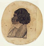
Bennelong
Woollarawarre Bennelong was a senior man of the Eora, an Aboriginal people of the Port Jackson area, at the time of the first British settlement in Australia, in 1788...
was a member of the Wangal clan.
The mangrove-lined shores of the Parramatta River
Parramatta River
The Parramatta River is a waterway in Sydney, New South Wales, Australia. The Parramatta River is the main tributary of Sydney Harbour, a branch of Port Jackson, along with the smaller Lane Cove and Duck Rivers....
were once an abundant source of food for the Wangal and the indigenous diet included Sydney cockles, Sydney rock oyster
Sydney rock oyster
The Sydney rock oyster, Saccostrea glomerata, formerly known as Saccostrea commercialis, is an oyster species endemic to Australia and New Zealand...
s, Hairy mussels and Hercules club whelks. The remains of these meals, known as shell middens
Midden
A midden, is an old dump for domestic waste which may consist of animal bone, human excrement, botanical material, vermin, shells, sherds, lithics , and other artifacts and ecofacts associated with past human occupation...
, can be seen in several areas, including Rodd Park in the neighbouring suburb of Rodd Point
Rodd Point, New South Wales
Rodd Point is a small suburb in the inner-west of Sydney, in the state of New South Wales, Australia. Rodd Point is located 9 kilometres west of the Sydney central business district in the local government area of the City of Canada Bay....
and at Cabarita Park in nearby Cabarita
Cabarita, New South Wales
Cabarita is a suburb in the inner-west of Sydney, in the state of New South Wales, Australia. Breakfast Point is located 16 kilometres west of the Sydney central business district, in the local government area of the City of Canada Bay....
. When the Europeans arrived, these shell middens could be found virtually all along the shores of Sydney Harbour. However, the European settlers used the materials in the middens to make lime for building mortar. As a result of this and of building activity along the foreshores, there are very few middens surviving today.
It is believed that the first contact by Europeans with the Wangal clan may have occurred on 5 February 1788 during an exploration of the Parramatta River
Parramatta River
The Parramatta River is a waterway in Sydney, New South Wales, Australia. The Parramatta River is the main tributary of Sydney Harbour, a branch of Port Jackson, along with the smaller Lane Cove and Duck Rivers....
, which was led by Captain John Hunter. This meeting, (which may be apocryphal), is recalled in the name of the suburb Breakfast Point
Breakfast Point, New South Wales
Breakfast Point is a suburb of Sydney, New South Wales, Australia. Breakfast Point is located 16 kilometres west of the Sydney central business district...
, as it took place while Hunter was having breakfast.
Governor Phillip's
Arthur Phillip
Admiral Arthur Phillip RN was a British admiral and colonial administrator. Phillip was appointed Governor of New South Wales, the first European colony on the Australian continent, and was the founder of the settlement which is now the city of Sydney.-Early life and naval career:Arthur Phillip...
notes suggest that an outbreak of smallpox in early 1789 would have had a devastating impact on the indigenous population
Indigenous peoples
Indigenous peoples are ethnic groups that are defined as indigenous according to one of the various definitions of the term, there is no universally accepted definition but most of which carry connotations of being the "original inhabitants" of a territory....
in Canada Bay
City of Canada Bay
The City of Canada Bay is a Local Government Area of New South Wales, Australia and located in the metropolitan area of Sydney. The city was formed in December 2000, following the merger of Concord and Drummoyne councils...
. Phillip not only recorded that half of the local aboriginal population was estimated to have died from the disease, but he also noted that the Aboriginal people always "retired from where the diseases appeared". The Wangal people are today remembered in local names such the Wangal Bushland Reserve in Mortlake
Mortlake, New South Wales
Mortlake is a suburb in the inner-west of Sydney, in the state of New South Wales, Australia. Mortlake is located 17 kilometres west of the Sydney central business district, in the local government area of the City of Canada Bay.-Transport:...
, Wangal Place in Five Dock and the suburb Wareemba
Wareemba, New South Wales
Wareemba is a small suburb in the inner-west of Sydney, in the state of New South Wales, Australia. Wareemba is located 12 kilometres west of the Sydney central business district in the local government area of the City of Canada Bay...
.
Origin of the name
The earliest written reference to Five Dock is in The Sydney Gazette of 3 February 1805, which mentions Five Dock Bay. However, the name probably dates back to the days of the First Settlement. All of the sources referenced are in agreement that it was derived from the shape of the bay along the Parramatta RiverParramatta River
The Parramatta River is a waterway in Sydney, New South Wales, Australia. The Parramatta River is the main tributary of Sydney Harbour, a branch of Port Jackson, along with the smaller Lane Cove and Duck Rivers....
. It appears that the names Five Docks and Five Dock were initially used interchangeably with the latter eventually became the accepted name.
According to a publication from the Maritime Services Board, Port of Sydney, (Volume 9, No 3, September 1965), "At the NE point of the bay there were five water worn indentations that were likened to docks, hence the name Five Dock." http://www.gnb.nsw.gov.au/name_search/extract?id=JPQlXtqban. There is widely contradictory information, however, about how many of these natural formations still exist. The Maritime Services Board publication concludes that there "are two of the five remaining". However, Eric Russell's Drummoyne: a western suburbs' history from 1794 states that one was lost with the construction of the 1881 Gladesville Bridge
Gladesville Bridge
Gladesville Bridge is an arch bridge near Gladesville that spans the Parramatta River, west of central Sydney, Australia. It links the suburbs of Huntleys Point and Drummoyne. It is a few kilometres upstream of the more famous Sydney Harbour Bridge and is part of Victoria Road...
, but "the others remain in 1982". Other sources give different numbers again. According to The Book of Sydney Suburbs, "three of them were affected by the construction of the southern approaches to the Gladesville Bridge".
Early European exploration and settlement
The first European exploration of the Canada Bay municipality occurred soon after the arrival of the First FleetFirst Fleet
The First Fleet is the name given to the eleven ships which sailed from Great Britain on 13 May 1787 with about 1,487 people, including 778 convicts , to establish the first European colony in Australia, in the region which Captain Cook had named New South Wales. The fleet was led by Captain ...
in 1788. This expedition was led by Captain John Hunter
John Hunter (New South Wales)
Vice-Admiral John Hunter, RN was a British naval officer, explorer, naturalist and colonial administrator who succeeded Arthur Phillip as the second governor of New South Wales, Australia from 1795 to 1800.-Overview:...
of the HMS Sirius
HMS Sirius (1786)
HMS Sirius was the flagship of the First Fleet, which set out from Portsmouth, England, in 1787 to establish the first European colony in New South Wales, Australia. Sirius was wrecked off the coast of Norfolk Island in the Pacific Ocean in 1790....
and included exploration of Iron Cove
Iron Cove, New South Wales
Iron Cove is a bay on the Parramatta River, in the inner-west of Sydney, in the state of New South Wales, Australia. It lies approximately due west of Sydney's central business district. It is surrounded by the suburbs of Birchgrove, Balmain, Rozelle, Lilyfield, Haberfield, Five Dock, Rodd Point,...
, Drummoyne
Drummoyne, New South Wales
Drummoyne is a suburb in the inner west of Sydney, in the state of New South Wales, Australia. It is located 6 kilometres west of the Sydney central business district and is the administrative centre for the local government area of the City of Canada Bay....
, Five Dock Bay and Hen and Chicken Bay
Hen and Chicken Bay, New South Wales
Hen and Chicken Bay is a bay on the Parramatta River, in the inner-west of Sydney, in the state of New South Wales, Australia. It lies approximately 8 kilometres due west of Sydney's central business district...
. In the 1790s, following the expedition, there were scattered and irregular efforts to create a settlement on the north-western side of Iron Cove Creek
Iron Cove Creek
Iron Cove Creek was a creek in Sydney, in the state of New South Wales, Australia. It is located in the inner-western suburbs of Croydon, Ashfield, Haberfield and Five Dock...
and, later on, along what is now Parramatta Road
Parramatta Road
.Parramatta Road is the major historical east-west artery of metropolitan Sydney, Australia, connecting the Sydney with Parramatta. It is the eastern-most part of the Great Western Highway. Much of its traffic has been diverted to modern expressways such as the M4 and the City West Link...
.
On 13 December 1794, Major Francis Grose granted some of the land on the peninsula to privates and NCOs
Non-commissioned officer
A non-commissioned officer , called a sub-officer in some countries, is a military officer who has not been given a commission...
from the New South Wales Corps
New South Wales Corps
The New South Wales Corps was formed in England in 1789 as a permanent regiment to relieve the marines who had accompanied the First Fleet to Australia. The regiment, led by Major Francis Grose, consisted of three companies...
as farmland. This area, part of the agricultural district of Concord, became known as the District of York Place. However, this attempt to settle the area was largely unsuccessful and most of these grants were subsequently annulled. In 1806, Governor King
Philip Gidley King
Captain Philip Gidley King RN was a British naval officer and colonial administrator. He is best known as the official founder of the first European settlement on Norfolk Island and as the third Governor of New South Wales.-Early years and establishment of Norfolk Island settlement:King was born...
made a grant of 6 km² of land to John Harris
John Harris, (Australian settler)
John Harris was a military surgeon and magistrate who became one of the earliest major landowners in the Colony of New South Wales, Australia....
. This grant included the area presently made up of Five Dock, Wareemba
Wareemba, New South Wales
Wareemba is a small suburb in the inner-west of Sydney, in the state of New South Wales, Australia. Wareemba is located 12 kilometres west of the Sydney central business district in the local government area of the City of Canada Bay...
, Russell Lea
Russell Lea, New South Wales
Russell Lea is a small suburb in the inner-west of Sydney, in the state of New South Wales, Australia. Russell Lea is located 8 kilometres west of the Sydney central business district in the local government area of the City of Canada Bay....
, Rodd Point
Rodd Point, New South Wales
Rodd Point is a small suburb in the inner-west of Sydney, in the state of New South Wales, Australia. Rodd Point is located 9 kilometres west of the Sydney central business district in the local government area of the City of Canada Bay....
and Drummoyne
Drummoyne, New South Wales
Drummoyne is a suburb in the inner west of Sydney, in the state of New South Wales, Australia. It is located 6 kilometres west of the Sydney central business district and is the administrative centre for the local government area of the City of Canada Bay....
. This large property became known as Five Dock Farm. It was never occupied by John Harris
John Harris, (Australian settler)
John Harris was a military surgeon and magistrate who became one of the earliest major landowners in the Colony of New South Wales, Australia....
despite him having a house built there. Harris nevertheless asserted his rights to the land against squatters and trespassers by placing several warning notices in the Sydney Gazette. The area remained almost untouched for thirty years as a consequence.
The earliest local roads were developed by the auctioneer Samuel Lyons
Samuel Lyons
Samuel Lyons 1791 - 1851 was a pardoned convict from London who rose to prominence in the Australian colony of New South Wales as a landowner and businessman. A tailor by trade, Lyons was sentenced to transportation for life in 1814. He made two attempts to escape from the convict life before...
, who purchased Five Dock Farm from Harris
John Harris, (Australian settler)
John Harris was a military surgeon and magistrate who became one of the earliest major landowners in the Colony of New South Wales, Australia....
in 1836. Lyons Road bears his surname today. Lyons
Samuel Lyons
Samuel Lyons 1791 - 1851 was a pardoned convict from London who rose to prominence in the Australian colony of New South Wales as a landowner and businessman. A tailor by trade, Lyons was sentenced to transportation for life in 1814. He made two attempts to escape from the convict life before...
soon subdivided the land into 133 lots and sold them at auction. These were 12-24 hectare blocks of land and were generally used for large country-style residences such as Barnstaple Manor.
Late 19th century
The late 19th century began to see increases in Five Dock's population as the public transport system improved. Ferry services to the area had started operation in 1834. However, ferries were really only useful to those who lived close to the Parramatta RiverParramatta River
The Parramatta River is a waterway in Sydney, New South Wales, Australia. The Parramatta River is the main tributary of Sydney Harbour, a branch of Port Jackson, along with the smaller Lane Cove and Duck Rivers....
. People living further inland would have been faced with a long walk to Ashfield Station
Ashfield railway station, Sydney
Ashfield railway station is a station located on the Main Suburban railway line of the CityRail network. It is located in the Sydney suburb of Ashfield and features five platforms...
until 1874, when the area began to be served by horse-buses, running along what is now Parramatta Road
Parramatta Road
.Parramatta Road is the major historical east-west artery of metropolitan Sydney, Australia, connecting the Sydney with Parramatta. It is the eastern-most part of the Great Western Highway. Much of its traffic has been diverted to modern expressways such as the M4 and the City West Link...
.
Recognised in Sands' Sydney Directory for the first time in 1870, Five Dock was slowly growing in importance. In 1861, the area's first school was opened in the grounds of St Albans Anglican Church. This eventually became Five Dock Public School. New premises for the school were completed in 1876 and classes there began in 1887. After campaigning by local residents, local government
Local government
Local government refers collectively to administrative authorities over areas that are smaller than a state.The term is used to contrast with offices at nation-state level, which are referred to as the central government, national government, or federal government...
was established in Five Dock on 25 July 1871, despite opposition from other locals. The area was linked to Hunters Hill by bridge in 1881 with the construction of the original Gladesville Bridge
Gladesville Bridge
Gladesville Bridge is an arch bridge near Gladesville that spans the Parramatta River, west of central Sydney, Australia. It links the suburbs of Huntleys Point and Drummoyne. It is a few kilometres upstream of the more famous Sydney Harbour Bridge and is part of Victoria Road...
.
The suburb was nevertheless distinctly rural when a steam-powered
Steam engine
A steam engine is a heat engine that performs mechanical work using steam as its working fluid.Steam engines are external combustion engines, where the working fluid is separate from the combustion products. Non-combustion heat sources such as solar power, nuclear power or geothermal energy may be...
tramway system, was introduced on 14 October 1890. The new steam tram ran from Leichhardt
Leichhardt, New South Wales
Leichhardt is a suburb in the inner-west of Sydney in New South Wales, Australia. Leichhardt is located 5 kilometres west of the Sydney central business district and is the administrative centre for the local government area of the Municipality of Leichhardt...
and terminated at the intersection of Great North Road and Lyons Road. From Leichhardt an electric tram continued to Circular Quay. The tram line was extended from Lyons Road all the way to Abbotsford
Abbotsford, New South Wales
Abbotsford is a suburb in the Inner West region of Sydney, in the state of New South Wales, Australia. Abbotsford is located 10 kilometres west of the Sydney central business district in the local government area of the City of Canada Bay...
in 1893.
Despite this significant development, which heralded an era of many changes, descriptions of Five Dock from 1890 mention its market gardens, farmland and large country estates. This was not particularly intense farming as many of the estates were described as being heavily wooded. The local issues of the time were primarily rural ones: stray horses and cattle had to be dealt with, badly driven horse buggies
Horse and buggy
A horse and buggy or horse and carriage refers to a light, simple, two-person carriage of the late 18th, 19th and early 20th centuries, drawn usually by one or sometimes by two horses...
and carts were a menace to pedestrians, roads and footpaths were poorly maintained, and there were a great many open drains. Probably the biggest nuisance to local residents was the herding of cattle through the suburb. In fact, during the 1890s, the movement of cattle through Five Dock, on its way to the abattoirs on Glebe Island, provoked such consternation and outrage that it was the subject of complaints to parliament as well as local council debate. Nevertheless, at the turn of the century, the area was on the brink of great changes. These were changes which had already occurred in the more prosperous neighbouring suburb of Drummoyne
Drummoyne, New South Wales
Drummoyne is a suburb in the inner west of Sydney, in the state of New South Wales, Australia. It is located 6 kilometres west of the Sydney central business district and is the administrative centre for the local government area of the City of Canada Bay....
, and meant that Five Dock would soon begin to lose its rural charm.
20th century
A colourful and lively debate arose in 1921 and 1922 over attempts by local residents to change the suburb's name. Five Dock was variously described in letters to the local newspaper, The Drummoyne Examiner, as a 'horrible name', 'a stigma', 'distasteful', 'very ugly', 'unwholesome', 'peculiar' and giving an 'impression of squalor'. The question of whether the name should be changed was put to the vote in a local referendum on 2 December 1922, with the 'no' vote carrying the day.Briefly, during the early 1930s, the Five Dock Locality of the New Guard
New Guard
The New Guard was a fascist movement in Australia formed in 1931. It was opposed to communism and democracy, called for class collaboration to replace class conflict, and engaged in street fighting against opponents and in plans for a coup d'etat against the Australian government...
(a kind of fascist paramilitary organisation primarily based in Sydney) grew rapidly and had close to 300 members in Five Dock at its very peak. New Guard
New Guard
The New Guard was a fascist movement in Australia formed in 1931. It was opposed to communism and democracy, called for class collaboration to replace class conflict, and engaged in street fighting against opponents and in plans for a coup d'etat against the Australian government...
meetings were held weekly. However, numbers in the Five Dock Locality began to dwindle sharply during 1932, even before the attempted kidnapping of Jack Lang
Jack Lang (Australian politician)
John Thomas Lang , usually referred to as J.T. Lang during his career, and familiarly known as "Jack" and nicknamed "The Big Fella" was an Australian politician who was Premier of New South Wales for two terms...
and his dismissal.
The pace of change in Five Dock quickened when private bus services started operating there in 1917, until being replaced by public buses in 1933. Further tram services which ran directly to the city centre came into service and more land subdivisions were made. As a result, by the end of the 1920s, Five Dock had largely lost the rural character it had maintained since the beginning of European settlement. It underwent further subdivisions during this decade and many of its brick houses date from this period.
Extensive industrial, as well as residential, development took place during the first half of the twentieth century in both Five Dock and Drummoyne
Drummoyne, New South Wales
Drummoyne is a suburb in the inner west of Sydney, in the state of New South Wales, Australia. It is located 6 kilometres west of the Sydney central business district and is the administrative centre for the local government area of the City of Canada Bay....
. Eventually, as land values increased, industry moved away. In recent years, several large former industrial sites have been redeveloped as residential housing.
In the early 1990s, the Locality Store was changed to Wareemba Post Office, to substitute for the new geographical location change.
Local names
Many Five Dock streets are named after mayors, aldermen and other associated with local government, including Charles Street, Corden Avenue, Henley Marine Drive, Hill Street, Howley Street, Ingham Avenue, Kerin Avenue, McGrath Avenue, McKinnon Avenue, Myler Street, Preston Avenue, Sutton Street, Timbrell Drive, Udall Avenue, West Street and William Street.Another series of streets is named after early landowners, subdividers and prominent local businessmen, including Ramsay Road, Taylor Street, Mitchell Street, Betts Avenue, Friend Avenue, Harris Road, Gildea Avenue and Bennett Avenue. Rickard Street, Noble Street, Heath Street and Augusta Street were named after Sir Arthur Rickard and members of his family. Rodd Road, Trevanion Street
and Barnstaple Road are named after Brent Clements Rodd and members of his family. A few streets take their name from local residents, including Mackaness Close and Langsworth Way.
The Great White Fleet
Great White Fleet
The Great White Fleet was the popular nickname for the United States Navy battle fleet that completed a circumnavigation of the globe from 16 December 1907 to 22 February 1909 by order of U.S. President Theodore Roosevelt. It consisted of 16 battleships divided into two squadrons, along with...
visited Sydney in August 1908 and several local street name
Street name
A street name or odonym is an identifying name given to a street. The street name usually forms part of the address...
s recall ships in the fleet. Connecticut Avenue is named after the USS Connecticut (BB-18)
USS Connecticut (BB-18)
USS Connecticut , the fourth United States Navy ship to be named after the state of Connecticut, was the lead ship of her class of six. Her keel was laid on 10 March 1903; launched on 29 September 1904, Connecticut was commissioned on 29 September 1906 as the most advanced ship in the U.S...
. Illinois Street is named after the USS Illinois (BB-7)
USS Illinois (BB-7)
USS Illinois , the second ship of the United States Navy to be named for the 21st state, was a battleship, the lead ship of her class....
. Minnesota Avenue takes its name from the USS Minnesota (BB-22)
USS Minnesota (BB-22)
USS Minnesota , a , was the second ship of the United States Navy in honor of the 32nd state, and the 24th battleship of the US Navy ....
. New Jersey Road takes its name from the USS New Jersey (BB-16)
USS New Jersey (BB-16)
USS New Jersey was a Virginia-class battleship of the United States Navy. She was the first ship to carry her name. New Jersey was launched on 10 November 1904 by Fore River Shipbuilding Company, Quincy, Massachusetts; sponsored by Mrs. William B. Kenney, daughter of Governor Franklin Murphy of...
.
A few streets are named after prominent people: Queens Road after Queen Victoria
Victoria of the United Kingdom
Victoria was the monarch of the United Kingdom of Great Britain and Ireland from 20 June 1837 until her death. From 1 May 1876, she used the additional title of Empress of India....
; Garfield Avenue after American President
President of the United States
The President of the United States of America is the head of state and head of government of the United States. The president leads the executive branch of the federal government and is the commander-in-chief of the United States Armed Forces....
James Garfield, Kingsford Avenue after Charles Kingsford Smith
Charles Kingsford Smith
Sir Charles Edward Kingsford Smith MC, AFC , often called by his nickname Smithy, was an early Australian aviator. In 1928, he earned global fame when he made the first trans-Pacific flight from the United States to Australia...
, Bevin Avenue after Ernest Bevin
Ernest Bevin
Ernest Bevin was a British trade union leader and Labour politician. He served as general secretary of the powerful Transport and General Workers' Union from 1922 to 1945, as Minister of Labour in the war-time coalition government, and as Foreign Secretary in the post-war Labour Government.-Early...
and Henry Lawson Avenue after Henry Lawson
Henry Lawson
Henry Lawson was an Australian writer and poet. Along with his contemporary Banjo Paterson, Lawson is among the best-known Australian poets and fiction writers of the colonial period and is often called Australia's "greatest writer"...
, who lived on Great North Road briefly in 1922. The name of Coronation Avenue commemorates the coronation of King George VI
George VI of the United Kingdom
George VI was King of the United Kingdom and the Dominions of the British Commonwealth from 11 December 1936 until his death...
.
A good number of streets take their names from well-known buildings or residences of the area. Arlington Street is named after the old Arlington Hotel. Other streets in this category include Erina Avenue, Fairlight Street, Longview Street, Maida Street, Murralong Avenue, Waterview Street and Wymstom Parade.
The name of Kirrang Street is taken from the aboriginal name for wattle
Acacia
Acacia is a genus of shrubs and trees belonging to the subfamily Mimosoideae of the family Fabaceae, first described in Africa by the Swedish botanist Carl Linnaeus in 1773. Many non-Australian species tend to be thorny, whereas the majority of Australian acacias are not...
. Wangal Place takes its name from the Wangal people, the original inhabitants of the region. Great North Road and Parramatta Road
Parramatta Road
.Parramatta Road is the major historical east-west artery of metropolitan Sydney, Australia, connecting the Sydney with Parramatta. It is the eastern-most part of the Great Western Highway. Much of its traffic has been diverted to modern expressways such as the M4 and the City West Link...
were named geographically for their destinations. York Avenue is a reference to York Place, an early name for part of the area. Regatta Road was named after the Drummoyne Regatta, which took place in the nearby Parramatta River
Parramatta River
The Parramatta River is a waterway in Sydney, New South Wales, Australia. The Parramatta River is the main tributary of Sydney Harbour, a branch of Port Jackson, along with the smaller Lane Cove and Duck Rivers....
.
St Alban's Anglican Church
St Alban's Anglican Church is a 1924 GothicGothic architecture
Gothic architecture is a style of architecture that flourished during the high and late medieval period. It evolved from Romanesque architecture and was succeeded by Renaissance architecture....
church, constructed of brick and stone. It is well-built church, using locally quarried stone, and remains very well preserved. It is a heritage item and is listed in the Department of the Environment and Heritage's Australian Heritage database. Significant or attractive features of the church include its interior carpentry, the pipe organ
Pipe organ
The pipe organ is a musical instrument that produces sound by driving pressurized air through pipes selected via a keyboard. Because each organ pipe produces a single pitch, the pipes are provided in sets called ranks, each of which has a common timbre and volume throughout the keyboard compass...
(which dates from 1891 and was built by W. Davidson) and its stained glass
Stained glass
The term stained glass can refer to coloured glass as a material or to works produced from it. Throughout its thousand-year history, the term has been applied almost exclusively to the windows of churches and other significant buildings...
. Some of the stained glass was transferred from the earlier church on the site and dates from around 1909. St Alban's rectory is on the same large site as the church, and together they form an important group. The foundations of the rectory, like those of the church, are constructed of local stone. In 2008 the church was part of an amalgamation with the Parishes of Ashfield and Haberfield, forming Christ Church Inner West Anglican Community.
Schools
All Hallows' Parish School, Domremy College, Five Dock Public School, Lucas Gardens School, Rosebank CollegeRosebank College
Rosebank College is a private, co-educational, secondary Catholic day school in the Benedictine tradition, located in Five Dock, an inner-western suburb of Sydney, New South Wales, Australia....
.
Five Dock Public School
The foundation stone of Five Dock Public School was laid in the grounds of St Albans church in 1858 , and it opened in 1861. Peter Dodds McCormickPeter Dodds McCormick
Peter Dodds McCormick , a Scottish-born schoolteacher, was the composer of the Australian national anthem "Advance Australia Fair"....
who composed the national anthem of Australia, Advance Australia Fair
Advance Australia Fair
"Advance Australia Fair" is the official national anthem of Australia. Created by the Scottish-born composer, Peter Dodds McCormick, the song was first performed in 1878, but did not gain its status as the official anthem until 1984. Until then, the song was sung in Australia as a patriotic song...
, was the headmaster of Five Dock Public School in 1865.
It is located on Henry Street.
Domremy College Five Dock
Named after Joan of Arc'sJoan of Arc
Saint Joan of Arc, nicknamed "The Maid of Orléans" , is a national heroine of France and a Roman Catholic saint. A peasant girl born in eastern France who claimed divine guidance, she led the French army to several important victories during the Hundred Years' War, which paved the way for the...
birthplace, Domremy
Domrémy-la-Pucelle
Domrémy-la-Pucelle is a commune in the Vosges department in Lorraine in northeastern France.The village, originally named Domrémy, is the birthplace of Joan of Arc. It has since been renamed Domrémy-la-Pucelle after Joan's nickname, la Pucelle d'Orléans .-Geography:Domrémy is positioned along the...
, Domremy College is a Catholic Secondary School
High school
High school is a term used in parts of the English speaking world to describe institutions which provide all or part of secondary education. The term is often incorporated into the name of such institutions....
for girls. It is located on First Avenue, opposite Five Dock Park. The school was founded in 1911, initially having just 12 students. The school originally taught students from infants through to the end of senior school. This was later scaled back to just years 7 to 10. However, since 1985, the school has taught girls from year 7 through to year 12. The Domremy Convent group is listed on the NSW Heritage Office State Heritage Register.
Houses
Housing in Five Dock consists mainly of detached dwellings. Like many suburbs in the inner-westInner West (Sydney)
The Inner West is a general term which is used to describe the metropolitan area directly to the west of the Sydney central business district, New South Wales, Australia...
of Sydney
Sydney
Sydney is the most populous city in Australia and the state capital of New South Wales. Sydney is located on Australia's south-east coast of the Tasman Sea. As of June 2010, the greater metropolitan area had an approximate population of 4.6 million people...
, Five Dock has some well-preserved examples of Australian Federation architecture
Federation architecture
Federation architecture refers to the architectural style in Australia, which was prevalent from around 1890 to 1920. The period refers to the Federation of Australia on 1 January 1901, when the Australian colonies collectively became the Commonwealth of Australia...
and California Bungalow
California Bungalow
California bungalows, known as Californian bungalows in Australia and are commonly called simply bungalows in America, are a form of residential structure that were widely popular across America and, to some extent, the world around the years 1910 to 1939.-Exterior features:Bungalows are 1 or 1½...
style residences. Many of these homes have been renovated however, and have not retained all of their original features. In the 1920s, the area experienced a housing boom and many older houses date from around this period. In addition, there is a diverse range of other architectural style
Architectural style
Architectural styles classify architecture in terms of the use of form, techniques, materials, time period, region and other stylistic influences. It overlaps with, and emerges from the study of the evolution and history of architecture...
s to be found in Five Dock, including many with an Italian
Italy
Italy , officially the Italian Republic languages]] under the European Charter for Regional or Minority Languages. In each of these, Italy's official name is as follows:;;;;;;;;), is a unitary parliamentary republic in South-Central Europe. To the north it borders France, Switzerland, Austria and...
or Greek
Greece
Greece , officially the Hellenic Republic , and historically Hellas or the Republic of Greece in English, is a country in southeastern Europe....
influence. These are typically large brick constructions with big gardens and often featuring ornamental decorations such as arches, columns and statuettes.
The majority of dwellings in Five Dock are detached houses, frequently with generously sized gardens. According to the 2001 census, of the 3,176 dwellings in the suburb, 1,718 consist of separate houses, 397 are other types of houses and 746 are apartments. Despite the preponderance of houses, Post-World War II development has involved a high proportion of apartment construction. Recently, several major residential developments have been completed. A example is the 'Pendium' development in Garfield Street, which includes 102 apartments, a refurbished supermarket and the local library. Another recent example is the redevelopment of the former EnergyAustralia
EnergyAustralia
EnergyAustralia is a large Australian electricity and natural gas supplier and retailer. A subsidiary of TRUenergy, it primarily supplies the Sydney, Newcastle and Central Coast areas of New South Wales and has, since market deregulation, increased its focus on retail supply opportunities in...
site in Fairlight Street into 93 units http://www.canadabay.nsw.gov.au/eservice/content/council/images/0415Agenda.pdf.
As of October 2005, there are a total of 51 items in the suburb that are heritage listed by the NSW Heritage Office http://www.heritage.nsw.gov.au/. In addition, the skateboard track in Five Dock Park is being considered for listing as a heritage item under the State Heritage Items Project http://www.heritage.nsw.gov.au/07_subnav_08_1.htm.
Commercial area
The Five Dock retail and commercial centre is made up of a long line of shops, banks, restaurants and other services which run for about 500 metres along Great North RoadGreat North Road (Australia)
The Great North Road is a historic road in Australia built by convicts between 1825 and 1836, being New South Wales's first road to traverse the rugged terrain hindering early agricultural expansion, effectively linking Sydney with the fertile Hunter Valley.The road is of such cultural...
in a section between Lyons Road and Queens Road. It features a high proportion of small local businesses, which range from hairdressers, florists and dentists to hardware store
Hardware store
Hardware stores, sometimes known as DIY stores, sell household hardware including: fasteners, hand tools, power tools, keys, locks, hinges, chains, plumbing supplies, electrical supplies, cleaning products, housewares, tools, utensils, paint, and lawn and garden products directly to consumers for...
s, accountants, delis and restaurants. During 2003 and 2004, Canada Bay Council
City of Canada Bay
The City of Canada Bay is a Local Government Area of New South Wales, Australia and located in the metropolitan area of Sydney. The city was formed in December 2000, following the merger of Concord and Drummoyne councils...
finished enhancements to the shopping strip by burying overhead electrical cables and phone lines, widening, repaving and fencing off footpaths, planting new trees and installing new street furniture. This has reinforced the emergence of this section of Great North Road as a cafe and restaurant strip. The Five Dock telephone exchange is located at 190-192 Great North Road.
Parks
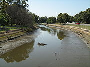
Five Dock has two separate stretches of publicly accessible foreshore on the Parramatta RiverParramatta River
The Parramatta River is a waterway in Sydney, New South Wales, Australia. The Parramatta River is the main tributary of Sydney Harbour, a branch of Port Jackson, along with the smaller Lane Cove and Duck Rivers....
. One of these foreshore stretches constitutes a small section of the Bay Run, a popular 7 km walking and cycling track which passes through several other suburbs along its way around Iron Cove
Iron Cove, New South Wales
Iron Cove is a bay on the Parramatta River, in the inner-west of Sydney, in the state of New South Wales, Australia. It lies approximately due west of Sydney's central business district. It is surrounded by the suburbs of Birchgrove, Balmain, Rozelle, Lilyfield, Haberfield, Five Dock, Rodd Point,...
. The other foreshore area lies on Hen and Chicken Bay
Hen and Chicken Bay, New South Wales
Hen and Chicken Bay is a bay on the Parramatta River, in the inner-west of Sydney, in the state of New South Wales, Australia. It lies approximately 8 kilometres due west of Sydney's central business district...
and Kings Bay, and features a pedestrian and bike path
Segregated cycle facilities
Segregated cycle facilities are marked lanes, tracks, shoulders and paths designated for use by cyclists from which motorised traffic is generally excluded...
leading around the bay towards Abbotsford
Abbotsford, New South Wales
Abbotsford is a suburb in the Inner West region of Sydney, in the state of New South Wales, Australia. Abbotsford is located 10 kilometres west of the Sydney central business district in the local government area of the City of Canada Bay...
.
In addition, there are several public parks located around Five Dock, the three largest being Timbrell Park, Five Dock Park and Halliday Park. A large section of Barnwell Park Golf Course, which is owned by Canada Bay Council
City of Canada Bay
The City of Canada Bay is a Local Government Area of New South Wales, Australia and located in the metropolitan area of Sydney. The city was formed in December 2000, following the merger of Concord and Drummoyne councils...
, is located in Five Dock. The northern part of the golf course
Golf
Golf is a precision club and ball sport, in which competing players use many types of clubs to hit balls into a series of holes on a golf course using the fewest number of strokes....
lies on reclaimed land
Land reclamation
Land reclamation, usually known as reclamation, is the process to create new land from sea or riverbeds. The land reclaimed is known as reclamation ground or landfill.- Habitation :...
.
Five Dock Park and Oval
Five Dock Park is listed on the NSW Heritage Office State Heritage Register and centres around The Five Dock War Memorial. The plaque at the memorial says that the foundation stone was laid in 1923. The memorial was renovated and rededicated in 1987. The park also contains a number of recreational facilities, including a large skate boarding area, a bowling club, tennis courtTennis court
A tennis court is where the game of tennis is played. It is a firm rectangular surface with a low net stretched across the center. The same surface can be used to play both doubles and singles.-Dimensions:...
s, an oval (used for junior rugby league matches and cricket), childcare facilities and an off-leash area for dogs. Originally constructed in 1979, the park's skate boarding and bmx
BMX
Bicycle motocross or BMX refers to the sport in which the main goal is extreme racing on bicycles in motocross style on tracks with inline start and expressive obstacles, and it is also the term that refers to the bicycle itself that is designed for dirt and motocross cycling.- History :BMX started...
area was extremely popular during the 1980s but gradually fell into disrepair. An article published in the Village Voice in 2002 said the National Skateboarders' Association had nominated Five Dock skate park
Skatepark
A skatepark is a purpose-built recreational environment made for skateboarding, BMX, aggressive inline skating and scooters. A skatepark may contain half-pipes, quarter pipes, spine transfers, handrails, funboxes, vert ramps, pyramids, banked ramps, full pipes, pools, bowls, snake runs stairsets,...
as one of the three worst in NSW because it was in such a poor condition, with a subsequent article discussing calls for its upgrade. The skate park has subsequently been completely redeveloped into what is claimed to be the largest skate bowl and one of the best in the Southern Hemisphere
Southern Hemisphere
The Southern Hemisphere is the part of Earth that lies south of the equator. The word hemisphere literally means 'half ball' or "half sphere"...
. The new skatepark opened in 2007 was built next to the 'old bowl' and was designed by Mick Mulhall.http://www.canadabay.nsw.gov.au/news/five_dock_skate_park_opens.html.
Road
The major regional roads that run through or adjoin Five Dock include Parramatta RoadParramatta Road
.Parramatta Road is the major historical east-west artery of metropolitan Sydney, Australia, connecting the Sydney with Parramatta. It is the eastern-most part of the Great Western Highway. Much of its traffic has been diverted to modern expressways such as the M4 and the City West Link...
, Lyons Road, Queens Road, Great North Road
Great North Road (Australia)
The Great North Road is a historic road in Australia built by convicts between 1825 and 1836, being New South Wales's first road to traverse the rugged terrain hindering early agricultural expansion, effectively linking Sydney with the fertile Hunter Valley.The road is of such cultural...
and the City West Link.
Bus
Five Dock is well-connected to the city centre and surrounding suburbs by public Sydney bus routes. These services include the following routes:- 406 Hurlstone ParkHurlstone Park, New South WalesHurlstone Park is a suburb in the inner-west of Sydney, in the state of New South Wales, Australia. Hurlstone Park is located 10 kilometres south-west of the Sydney central business district and is mostly in the local government area of the City of Canterbury, and partly in the Municipality of...
- Ashfield StationAshfield railway station, SydneyAshfield railway station is a station located on the Main Suburban railway line of the CityRail network. It is located in the Sydney suburb of Ashfield and features five platforms...
- HaberfieldHaberfield, New South WalesHaberfield is a suburb in the inner-west of Sydney, in the state of New South Wales, Australia. Haberfield is located 9 kilometres west of the Sydney central business district in the local government area of the Municipality of Ashfield....
- Five Dock - 415 Campsie - BurwoodBurwood, New South WalesBurwood is a suburb in the inner-west of Sydney, in the state of New South Wales, Australia. Burwood is located 12 kilometres west of the Sydney central business district and is the administrative centre for the local government area of Burwood Council....
- ChiswickChiswick, New South WalesChiswick is a suburb in the inner-west region of Sydney, in the state of New South Wales, Australia. It is located 9 kilometres west of the Sydney central business district in the local government area of the City of Canada Bay. Chiswick sits on the peninsula between Abbotsford Bay and Five Dock... - 437 Circular Quay - Railway SquareBroadway, New South WalesBroadway is a road in Sydney, in the state of New South Wales, Australia. The road constitutes the border between the suburbs of Ultimo and Chippendale . Broadway is also an urban locality....
- Rodd PointRodd Point, New South WalesRodd Point is a small suburb in the inner-west of Sydney, in the state of New South Wales, Australia. Rodd Point is located 9 kilometres west of the Sydney central business district in the local government area of the City of Canada Bay....
- Five Dock, New South Wales|Chiswick]] - 438 Circular Quay - Railway SquareBroadway, New South WalesBroadway is a road in Sydney, in the state of New South Wales, Australia. The road constitutes the border between the suburbs of Ultimo and Chippendale . Broadway is also an urban locality....
- LeichhardtLeichhardt, New South WalesLeichhardt is a suburb in the inner-west of Sydney in New South Wales, Australia. Leichhardt is located 5 kilometres west of the Sydney central business district and is the administrative centre for the local government area of the Municipality of Leichhardt...
- Five Dock Shops - AbbotsfordAbbotsford, New South WalesAbbotsford is a suburb in the Inner West region of Sydney, in the state of New South Wales, Australia. Abbotsford is located 10 kilometres west of the Sydney central business district in the local government area of the City of Canada Bay... - L38 Circular Quay - Railway SquareBroadway, New South WalesBroadway is a road in Sydney, in the state of New South Wales, Australia. The road constitutes the border between the suburbs of Ultimo and Chippendale . Broadway is also an urban locality....
- LeichhardtLeichhardt, New South WalesLeichhardt is a suburb in the inner-west of Sydney in New South Wales, Australia. Leichhardt is located 5 kilometres west of the Sydney central business district and is the administrative centre for the local government area of the Municipality of Leichhardt...
- Five Dock Shops - AbbotsfordAbbotsford, New South WalesAbbotsford is a suburb in the Inner West region of Sydney, in the state of New South Wales, Australia. Abbotsford is located 10 kilometres west of the Sydney central business district in the local government area of the City of Canada Bay...
(limited stops) - 439 Circular Quay - Railway SquareBroadway, New South WalesBroadway is a road in Sydney, in the state of New South Wales, Australia. The road constitutes the border between the suburbs of Ultimo and Chippendale . Broadway is also an urban locality....
- LeichhardtLeichhardt, New South WalesLeichhardt is a suburb in the inner-west of Sydney in New South Wales, Australia. Leichhardt is located 5 kilometres west of the Sydney central business district and is the administrative centre for the local government area of the Municipality of Leichhardt...
- Five Dock Shops - Canada BayCanada Bay, New South WalesCanada Bay is a suburb in the inner-west of Sydney, in the state of New South Wales, Australia. Canada Bay is located 11 kilometres west of the Sydney central business district, in the local government area of City of Canada Bay....
- Concord Shops - Cabarita Junction - MortlakeMortlake, New South WalesMortlake is a suburb in the inner-west of Sydney, in the state of New South Wales, Australia. Mortlake is located 17 kilometres west of the Sydney central business district, in the local government area of the City of Canada Bay.-Transport:... - L39 Circular Quay - Railway SquareBroadway, New South WalesBroadway is a road in Sydney, in the state of New South Wales, Australia. The road constitutes the border between the suburbs of Ultimo and Chippendale . Broadway is also an urban locality....
- LeichhardtLeichhardt, New South WalesLeichhardt is a suburb in the inner-west of Sydney in New South Wales, Australia. Leichhardt is located 5 kilometres west of the Sydney central business district and is the administrative centre for the local government area of the Municipality of Leichhardt...
- Five Dock Shops - Canada BayCanada Bay, New South WalesCanada Bay is a suburb in the inner-west of Sydney, in the state of New South Wales, Australia. Canada Bay is located 11 kilometres west of the Sydney central business district, in the local government area of City of Canada Bay....
- Concord Shops - Cabarita Junction - MortlakeMortlake, New South WalesMortlake is a suburb in the inner-west of Sydney, in the state of New South Wales, Australia. Mortlake is located 17 kilometres west of the Sydney central business district, in the local government area of the City of Canada Bay.-Transport:...
(limited stops) - 460 Five Dock Shops - Canada BayCanada Bay, New South WalesCanada Bay is a suburb in the inner-west of Sydney, in the state of New South Wales, Australia. Canada Bay is located 11 kilometres west of the Sydney central business district, in the local government area of City of Canada Bay....
- Concord HospitalConcord Repatriation General HospitalConcord Repatriation General Hospital , commonly referred to as simply Concord Hospital, is a major hospital in Sydney, Australia, located on Hospital Road in Concord... - 461 Queen Victoria BuildingQueen Victoria BuildingThe Queen Victoria Building, or QVB, is a late nineteenth century building by the architect George McRae in the central business district of Sydney, Australia. The Romanesque Revival building is 30 metres wide by 190 metres long, and fills a city block, bounded by George, Market, York and Druitt...
- AshfieldAshfield, New South WalesAshfield is a suburb in the inner-west of Sydney, in the state of New South Wales, Australia. Ashfield is about 9 kilometres south-west of the Sydney central business district and is the administrative centre for the local government area of the Municipality of Ashfield.The official name for the...
- Burwood StationBurwood railway station, SydneyBurwood is a major station on the main suburban line in the suburb of Burwood in Sydney. The station is located on Burwood Road, close to major shops and schools, and consists of platforms on all six of the tracks through the station. The concourse is situated below the platforms with access to... - 490 Hurstville Station - KingsgroveKingsgrove, New South WalesKingsgrove is a suburb in southern Sydney, in the state of New South Wales, Australia. Kingsgrove is located 13 kilometres south of the Sydney central business district and lies across the local government areas of the City of Rockdale, the City of Hurstville and the City of Canterbury...
- CampsieCampsie, New South WalesCampsie is a suburb in south-western Sydney, in the state of New South Wales, Australia. Campsie is located 13 kilometres south-west of the Sydney central business district, on the southern bank of the Cooks River. Campsie is the commercial and administrative centre of the City of...
- Croydon ParkCroydon Park, New South WalesCroydon Park is a suburb, in the inner-west of Sydney, in the state of New South Wales, Australia. Croydon Park is about 13 kilometres south-west of the Sydney central business district and is divided between the local government areas of the City of Canterbury, Burwood Council and Municipality of...
- BurwoodBurwood, New South WalesBurwood is a suburb in the inner-west of Sydney, in the state of New South Wales, Australia. Burwood is located 12 kilometres west of the Sydney central business district and is the administrative centre for the local government area of Burwood Council....
- Five Dock - Rodd PointRodd Point, New South WalesRodd Point is a small suburb in the inner-west of Sydney, in the state of New South Wales, Australia. Rodd Point is located 9 kilometres west of the Sydney central business district in the local government area of the City of Canada Bay....
- DrummoyneDrummoyne, New South WalesDrummoyne is a suburb in the inner west of Sydney, in the state of New South Wales, Australia. It is located 6 kilometres west of the Sydney central business district and is the administrative centre for the local government area of the City of Canada Bay.... - 491 Hurstville Station - Bexley North Station - Bardwell Park Station - EarlwoodEarlwood, New South WalesEarlwood is a suburb in the inner-west of Sydney, in the state of New South Wales, Australia. Earlwood is located 12 kilometres south of the Sydney central business district, in the local government area of the City of Canterbury...
- CanterburyCanterbury, New South Wales-Commercial area:Canterbury has a mixture of residential, commercial and industrial developments. Commercial developments are mostly situated on Canterbury Road and surrounding streets...
- AshburyAshbury, New South WalesAshbury is a suburb in inner-west Sydney, in the state of New South Wales, Australia. It is located 10 kilometres south-west of the Sydney central business district. The suburb lies in the local government area of the City of Canterbury with some areas in Ashfield Municipality...
- Ashfield StationAshfield railway station, SydneyAshfield railway station is a station located on the Main Suburban railway line of the CityRail network. It is located in the Sydney suburb of Ashfield and features five platforms...
- Five Dock - 492 Rockdale Station - BexleyBexley, New South WalesBexley is a suburb in southern Sydney, in the state of New South Wales, Australia. Bexley is located 14 kilometres south of the Sydney central business district, in the local government area of the City of Rockdale and is part of the St George area.-History:...
- KingsgroveKingsgrove, New South WalesKingsgrove is a suburb in southern Sydney, in the state of New South Wales, Australia. Kingsgrove is located 13 kilometres south of the Sydney central business district and lies across the local government areas of the City of Rockdale, the City of Hurstville and the City of Canterbury...
- CampsieCampsie, New South WalesCampsie is a suburb in south-western Sydney, in the state of New South Wales, Australia. Campsie is located 13 kilometres south-west of the Sydney central business district, on the southern bank of the Cooks River. Campsie is the commercial and administrative centre of the City of...
- Croydon ParkCroydon Park, New South WalesCroydon Park is a suburb, in the inner-west of Sydney, in the state of New South Wales, Australia. Croydon Park is about 13 kilometres south-west of the Sydney central business district and is divided between the local government areas of the City of Canterbury, Burwood Council and Municipality of...
- BurwoodBurwood, New South WalesBurwood is a suburb in the inner-west of Sydney, in the state of New South Wales, Australia. Burwood is located 12 kilometres west of the Sydney central business district and is the administrative centre for the local government area of Burwood Council....
- Five Dock - DrummoyneDrummoyne, New South WalesDrummoyne is a suburb in the inner west of Sydney, in the state of New South Wales, Australia. It is located 6 kilometres west of the Sydney central business district and is the administrative centre for the local government area of the City of Canada Bay.... - 502 Wynyard StationWynyard railway station, SydneyWynyard is a major underground CityRail station in the central business district of Sydney, Australia, 2.05 km from Central. Wynyard averages 108000 passenger movements per day Monday to Friday.-History:The station opened on 28 February 1932...
- RozelleRozelle, New South WalesRozelle is a suburb in the inner west of Sydney, in the state of New South Wales, Australia. It is located 4 kilometres west of the Sydney central business district, in the local government area of the Municipality of Leichhardt....
- DrummoyneDrummoyne, New South WalesDrummoyne is a suburb in the inner west of Sydney, in the state of New South Wales, Australia. It is located 6 kilometres west of the Sydney central business district and is the administrative centre for the local government area of the City of Canada Bay....
- Russell LeaRussell Lea, New South WalesRussell Lea is a small suburb in the inner-west of Sydney, in the state of New South Wales, Australia. Russell Lea is located 8 kilometres west of the Sydney central business district in the local government area of the City of Canada Bay....
- Five Dock - Canada BayCanada Bay, New South WalesCanada Bay is a suburb in the inner-west of Sydney, in the state of New South Wales, Australia. Canada Bay is located 11 kilometres west of the Sydney central business district, in the local government area of City of Canada Bay....
- Bayview ParkConcord, New South WalesConcord is a suburb in the inner west of Sydney, in the state of New South Wales, Australia. It is located 15 kilometres west of the Sydney central business district, in the local government area of the City of Canada Bay....
Train and ferry
The closest CityRailCityRail
CityRail is an operating brand of RailCorp, a corporation owned by the state government of New South Wales, Australia. It is responsible for providing commuter rail services, and some coach services, in and around Sydney, Newcastle and Wollongong, the three largest cities of New South Wales. It is...
railway stations to Five Dock are Ashfield
Ashfield railway station, Sydney
Ashfield railway station is a station located on the Main Suburban railway line of the CityRail network. It is located in the Sydney suburb of Ashfield and features five platforms...
and Croydon
Croydon railway station, Sydney
-Transport links:NightRide runs two routes via Croydon station:*Route N50 - Between Liverpool and City *Route N60 - Between Fairfield station and City -Neighbouring stations:-References:...
; both being just over 2.5 km from the main shopping centre. The major suburban station of Strathfield is also within fairly close driving distance. Croydon Station
Croydon railway station, Sydney
-Transport links:NightRide runs two routes via Croydon station:*Route N50 - Between Liverpool and City *Route N60 - Between Fairfield station and City -Neighbouring stations:-References:...
was originally named Five Dock Station when it opened in 1875. The name was changed to Croydon soon afterwards. There are ferry services to the city from the nearby suburbs of Drummoyne
Drummoyne, New South Wales
Drummoyne is a suburb in the inner west of Sydney, in the state of New South Wales, Australia. It is located 6 kilometres west of the Sydney central business district and is the administrative centre for the local government area of the City of Canada Bay....
, Chiswick
Chiswick, New South Wales
Chiswick is a suburb in the inner-west region of Sydney, in the state of New South Wales, Australia. It is located 9 kilometres west of the Sydney central business district in the local government area of the City of Canada Bay. Chiswick sits on the peninsula between Abbotsford Bay and Five Dock...
and Abbotsford
Abbotsford, New South Wales
Abbotsford is a suburb in the Inner West region of Sydney, in the state of New South Wales, Australia. Abbotsford is located 10 kilometres west of the Sydney central business district in the local government area of the City of Canada Bay...
.
Population
Demographics
Five Dock is an established suburb with a population of over 7,900 in the 2006 census. Like the nearby suburbs of HaberfieldHaberfield, New South Wales
Haberfield is a suburb in the inner-west of Sydney, in the state of New South Wales, Australia. Haberfield is located 9 kilometres west of the Sydney central business district in the local government area of the Municipality of Ashfield....
and Leichhardt
Leichhardt, New South Wales
Leichhardt is a suburb in the inner-west of Sydney in New South Wales, Australia. Leichhardt is located 5 kilometres west of the Sydney central business district and is the administrative centre for the local government area of the Municipality of Leichhardt...
, Five Dock has a large population of Italian
Italy
Italy , officially the Italian Republic languages]] under the European Charter for Regional or Minority Languages. In each of these, Italy's official name is as follows:;;;;;;;;), is a unitary parliamentary republic in South-Central Europe. To the north it borders France, Switzerland, Austria and...
immigrants. According to the 2006 census more than 1 in 4 residents claim Italian ancestry and roughly 12% of the population was born in Italy
Italy
Italy , officially the Italian Republic languages]] under the European Charter for Regional or Minority Languages. In each of these, Italy's official name is as follows:;;;;;;;;), is a unitary parliamentary republic in South-Central Europe. To the north it borders France, Switzerland, Austria and...
. This Italian influence is reflected in several ways, for instance in the style of the suburb's restaurants, cafes and delis. Five Dock Public School has had an Italian language
Italian language
Italian is a Romance language spoken mainly in Europe: Italy, Switzerland, San Marino, Vatican City, by minorities in Malta, Monaco, Croatia, Slovenia, France, Libya, Eritrea, and Somalia, and by immigrant communities in the Americas and Australia...
teaching program since 1981 and there are local private language schools offering Italian
Italian language
Italian is a Romance language spoken mainly in Europe: Italy, Switzerland, San Marino, Vatican City, by minorities in Malta, Monaco, Croatia, Slovenia, France, Libya, Eritrea, and Somalia, and by immigrant communities in the Americas and Australia...
classes. In addition, Five Dock has an annual street festival
Festival
A festival or gala is an event, usually and ordinarily staged by a local community, which centers on and celebrates some unique aspect of that community and the Festival....
called Ferragosto, based on the traditional Italian festival of the same name.
Notable residents
- John HarrisJohn Harris, (Australian settler)John Harris was a military surgeon and magistrate who became one of the earliest major landowners in the Colony of New South Wales, Australia....
, a military surgeon and magistrate, one of the first European landowners. - Samuel LyonsSamuel LyonsSamuel Lyons 1791 - 1851 was a pardoned convict from London who rose to prominence in the Australian colony of New South Wales as a landowner and businessman. A tailor by trade, Lyons was sentenced to transportation for life in 1814. He made two attempts to escape from the convict life before...
, a former convict who became a wealthy landowner and prominent citizen, purchasing Five Dock Farm in 1838. - Sir Thomas HenleyThomas HenleySir Thomas Henley KBE was an Australian politician, elected as a member of the New South Wales Legislative Assembly.-Early years:...
, alderman and mayor of Drummoyne who was largely responsible for the reuniting of Five Dock and Drummoyne Councils in 1902. - Peter Dodds McCormickPeter Dodds McCormickPeter Dodds McCormick , a Scottish-born schoolteacher, was the composer of the Australian national anthem "Advance Australia Fair"....
, the composer of Advance Australia FairAdvance Australia Fair"Advance Australia Fair" is the official national anthem of Australia. Created by the Scottish-born composer, Peter Dodds McCormick, the song was first performed in 1878, but did not gain its status as the official anthem until 1984. Until then, the song was sung in Australia as a patriotic song...
, became headmaster of Five Dock Public School in 1865. - Jeff FenechJeff FenechJeff Fenech is a retired Australian boxer and a three-time world champion who is now a boxing trainer.-Boxing career:...
, the Australian boxer, is from Five Dock http://www.smh.com.au/articles/2004/01/05/1073151241374.html.
Politics
Five Dock is in the federal seat of ReidDivision of Reid
The Division of Reid is an Australian Electoral Division in the state of New South Wales. It is located in the western suburbs of Sydney, and includes the suburbs of Abbotsford, Auburn , Berala , Breakfast Point, Burwood , Cabarita, Canada Bay, Chiswick, Concord, Concord West, Croydon , Drummoyne,...
, an electoral division which includes the surrounding suburbs of Burwood
Burwood, New South Wales
Burwood is a suburb in the inner-west of Sydney, in the state of New South Wales, Australia. Burwood is located 12 kilometres west of the Sydney central business district and is the administrative centre for the local government area of Burwood Council....
, Concord
Concord, New South Wales
Concord is a suburb in the inner west of Sydney, in the state of New South Wales, Australia. It is located 15 kilometres west of the Sydney central business district, in the local government area of the City of Canada Bay....
, Drummoyne
Drummoyne, New South Wales
Drummoyne is a suburb in the inner west of Sydney, in the state of New South Wales, Australia. It is located 6 kilometres west of the Sydney central business district and is the administrative centre for the local government area of the City of Canada Bay....
, Haberfield
Haberfield, New South Wales
Haberfield is a suburb in the inner-west of Sydney, in the state of New South Wales, Australia. Haberfield is located 9 kilometres west of the Sydney central business district in the local government area of the Municipality of Ashfield....
, Homebush
Homebush, New South Wales
Homebush is an inner western suburb of Sydney, in the state of New South Wales, Australia. Homebush is located 15 kilometres west of the Sydney central business district, in the local government area of the Municipality of Strathfield. Homebush West and Homebush Bay are separate suburbs...
, Mortlake
Mortlake, New South Wales
Mortlake is a suburb in the inner-west of Sydney, in the state of New South Wales, Australia. Mortlake is located 17 kilometres west of the Sydney central business district, in the local government area of the City of Canada Bay.-Transport:...
, Rhodes
Rhodes, New South Wales
Rhodes is a suburb in the inner-west of Sydney, in the state of New South Wales, Australia. Rhodes is located 16 kilometres west of the Sydney central business district, in the local government area of the City of Canada Bay...
and Strathfield
Strathfield, New South Wales
Strathfield is an Inner West suburb of Sydney, in the state of New South Wales, Australia. Strathfield is located 14 kilometres west of the Sydney central business district and is the administrative centre of the local government area of the Municipality of Strathfield...
. It is a marginal Labor
Australian Labor Party
The Australian Labor Party is an Australian political party. It has been the governing party of the Commonwealth of Australia since the 2007 federal election. Julia Gillard is the party's federal parliamentary leader and Prime Minister of Australia...
seat which has been held by John Murphy
John Murphy (Australian politician)
John Paul Murphy , Australian politician, is an Australian Labor Party member of the Australian House of Representatives since October 1998, representing Lowe and then Reid, New South Wales. He was born in Dunedoo, New South Wales...
since 1998.
In the NSW parliament
Parliament of New South Wales
The Parliament of New South Wales, located in Parliament House on Macquarie Street, Sydney, is the main legislative body in the Australian state of New South Wales . It is a bicameral parliament elected by the people of the state in general elections. The parliament shares law making powers with...
, Five Dock is in the electoral division of Drummoyne, which is somewhat smaller than the federal division, but occupies much of the same area. The seat is held by Angela D'Amore
Angela D'Amore
Angela D'Amore , a former Australian politician, was a member of the New South Wales Legislative Assembly, representing the electorate of Drummoyne from 2003 until 2011 initially for the Australian Labor Party until 2010, and then as an independent member until her retirement from politics in 2011...
of the Australian Labor Party
Australian Labor Party
The Australian Labor Party is an Australian political party. It has been the governing party of the Commonwealth of Australia since the 2007 federal election. Julia Gillard is the party's federal parliamentary leader and Prime Minister of Australia...
.
Residential developments and population growth
As the Sydney Metropolitan areaMetropolitan area
The term metropolitan area refers to a region consisting of a densely populated urban core and its less-populated surrounding territories, sharing industry, infrastructure, and housing. A metropolitan area usually encompasses multiple jurisdictions and municipalities: neighborhoods, townships,...
is projected to continue experiencing population growth, urban consolidation and renewal is an issue facing many suburbs. Major residential developments in Five Dock include the following:
- Kings Bay Estate - Developer: St Hilliers, Landcom, former Hycraft carpet factory site, 4.25 ha, 267 dwellings, 2001, 11-27 Harris Road.
- Pendium Apartments - Developer: Barclay Mowlem, 102 dwellings, supermarket and library, 2004, 4-12 Garfield Street.
- Axis - 9,030 square metres, 93 dwellings, former EnergyAustraliaEnergyAustraliaEnergyAustralia is a large Australian electricity and natural gas supplier and retailer. A subsidiary of TRUenergy, it primarily supplies the Sydney, Newcastle and Central Coast areas of New South Wales and has, since market deregulation, increased its focus on retail supply opportunities in...
site, 57-63 Fairlight Street & 48 Great North Road.
In addition, a significant number of smaller-scale residential redevelopments have been completed in recent years. A example is Prego, adjoining the Kings Bay Estate at 92-96 Kings Road, which has 12 dwellings.
Commercial developments
Prior to being redeveloped as residential housing, the site at 11-27 Harris Road was the subject of a development application for a major shopping centre to be known as Five Dock Marketplace in 1993. This was submitted to the local council by Restifa & Partners and was to include a Woolworths supermarket, along with specialty storeSpecialty store
Specialty stores are small stores which specialize in a specific range of merchandise and related items. Most stores have an extensive depth of stock in the item that they specialize in and provide high levels of service and expertise...
s. The proposal was rejected for several reasons. Aside from concern over increased local traffic, the most significant reason was probably that it was considered that such a major shopping centre would have a detrimental effect on the existing shopping precinct. A report prepared for Drummoyne Council considered that it would create a two-pole shopping centre as it was located too far from the existing shopping area along Great North Road.
Traffic congestion
Although most of Five Dock's streets are quiet residential areas, the suburb has several major roads that suffer from traffic congestionTraffic congestion
Traffic congestion is a condition on road networks that occurs as use increases, and is characterized by slower speeds, longer trip times, and increased vehicular queueing. The most common example is the physical use of roads by vehicles. When traffic demand is great enough that the interaction...
. This is the result of a combination of local traffic and the fact that the suburb lies along one of the major east-west road transport corridors between the city
Sydney central business district
The Sydney central business district is the main commercial centre of Sydney, New South Wales, Australia. It extends southwards for about 3 kilometres from Sydney Cove, the point of first European settlement. Its north–south axis runs from Circular Quay in the north to Central railway station in...
and the M4
Metroad 4
Metroad 4 is a Metroad in Sydney, New South Wales, Australia. It connects the inner-west of Sydney with the outer western suburbs. It mostly follows what was previously National Highway 32 from the Western Distributor in the CBD, west to the Great Western Highway at Lapstone...
connecting to the Western Suburbs
Western Sydney
Western Sydney is a major region of Sydney, Australia. It has a number of different definitions but one consistently used is the region composed of the 11 councils which until recently were all members of the Western Sydney Regional Organisation of Councils:* Auburn Council* Bankstown City Council*...
and Greater Western Sydney
Greater Western Sydney
Greater Western Sydney is a term used to describe the western region of the metropolitan area of Sydney, Australia. The University of Western Sydney defines Greater Western Sydney as comprising 14 local government areas...
. The worst areas for congestion are Parramatta Road
Parramatta Road
.Parramatta Road is the major historical east-west artery of metropolitan Sydney, Australia, connecting the Sydney with Parramatta. It is the eastern-most part of the Great Western Highway. Much of its traffic has been diverted to modern expressways such as the M4 and the City West Link...
, Queens Road and Great North Road
Great North Road (Australia)
The Great North Road is a historic road in Australia built by convicts between 1825 and 1836, being New South Wales's first road to traverse the rugged terrain hindering early agricultural expansion, effectively linking Sydney with the fertile Hunter Valley.The road is of such cultural...
(between Lyons Road and Parramatta Road). Traffic congestion has not been helped by the fact that Great North Road was significantly narrowed in 2003 and now only carries one lane in each direction through the main shopping centre.
One of the contributing factors to road congestion is that the M4
Metroad 4
Metroad 4 is a Metroad in Sydney, New South Wales, Australia. It connects the inner-west of Sydney with the outer western suburbs. It mostly follows what was previously National Highway 32 from the Western Distributor in the CBD, west to the Great Western Highway at Lapstone...
has no direct connection to the City West Link Road
City West Link Road
City West Link Road is a link road in Sydney, Australia. It makes up a section of Metroad 4 between Leichhardt, Haberfield and Five Dock. As such, it provides an alternative route to Parramatta Road into Sydney's CBD from the Inner-West....
so all traffic making this journey must use local roads through Five Dock. Recent controversy began in July 2002, when the NSW State Government proposed major road construction to connect these two roads directly. The government's and the RTA's
Roads and Traffic Authority
The Roads and Traffic Authority is a former New South Wales government agency that was responsible for major road infrastructure, licensing of drivers, and registration of motor vehicles. The RTA directly managed State roads and provided funding to local councils for regional and local roads...
preferred option was a 3.6-kilometre tunnel, which was to emerge in Haberfield
Haberfield, New South Wales
Haberfield is a suburb in the inner-west of Sydney, in the state of New South Wales, Australia. Haberfield is located 9 kilometres west of the Sydney central business district in the local government area of the Municipality of Ashfield....
. Local residents campaigned strongly against this option, arguing that it would move the current bottlenecks into Haberfield. Other reasons put forward against the tunnel included the claim that drivers would simply avoid a new toll road
Toll road
A toll road is a privately or publicly built road for which a driver pays a toll for use. Structures for which tolls are charged include toll bridges and toll tunnels. Non-toll roads are financed using other sources of revenue, most typically fuel tax or general tax funds...
and continue to use Parramatta Road
Parramatta Road
.Parramatta Road is the major historical east-west artery of metropolitan Sydney, Australia, connecting the Sydney with Parramatta. It is the eastern-most part of the Great Western Highway. Much of its traffic has been diverted to modern expressways such as the M4 and the City West Link...
.
All three plans for the M4
Metroad 4
Metroad 4 is a Metroad in Sydney, New South Wales, Australia. It connects the inner-west of Sydney with the outer western suburbs. It mostly follows what was previously National Highway 32 from the Western Distributor in the CBD, west to the Great Western Highway at Lapstone...
East were put on hold in April 2005, following criticism in 2004 from Sustainability Commissioner, Professor Peter Newman
Peter Newman (Australian)
Peter William Geoffrey Newman is an environmental scientist, author and educator based in Perth, Western Australia. He is currently Professor of Sustainability at Curtin University and since 2008 member of Infrastructure Australia....
http://www.smh.com.au/articles/2004/06/16/1087244980253.html. Craig Knowles
Craig Knowles
Craig John Knowles is a former Australian politician and member of the New South Wales Legislative Assembly from 1990 to 2005....
, then Minister for Infrastructure and Planning said the government is still committed to creating a link between the M4
Metroad 4
Metroad 4 is a Metroad in Sydney, New South Wales, Australia. It connects the inner-west of Sydney with the outer western suburbs. It mostly follows what was previously National Highway 32 from the Western Distributor in the CBD, west to the Great Western Highway at Lapstone...
and the city.