

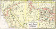
Feather River Route
Encyclopedia
Rail transport
Rail transport is a means of conveyance of passengers and goods by way of wheeled vehicles running on rail tracks. In contrast to road transport, where vehicles merely run on a prepared surface, rail vehicles are also directionally guided by the tracks they run on...
line that was built and operated by the Western Pacific Railroad
Western Pacific Railroad
The Western Pacific Railroad was a Class I railroad in the United States. It was formed in 1903 as an attempt to break the near-monopoly the Southern Pacific Railroad had on rail service into northern California...
. It was constructed between 1906 and 1909, and connects the cities of Oakland, California
Oakland, California
Oakland is a major West Coast port city on San Francisco Bay in the U.S. state of California. It is the eighth-largest city in the state with a 2010 population of 390,724...
, and Salt Lake City, Utah
Salt Lake City, Utah
Salt Lake City is the capital and the most populous city of the U.S. state of Utah. The name of the city is often shortened to Salt Lake or SLC. With a population of 186,440 as of the 2010 Census, the city lies in the Salt Lake City metropolitan area, which has a total population of 1,124,197...
. The line was built to compete with the Central Pacific Railroad
Central Pacific Railroad
The Central Pacific Railroad is the former name of the railroad network built between California and Utah, USA that formed part of the "First Transcontinental Railroad" in North America. It is now part of the Union Pacific Railroad. Many 19th century national proposals to build a transcontinental...
(and later Southern Pacific Railroad
Southern Pacific Railroad
The Southern Pacific Transportation Company , earlier Southern Pacific Railroad and Southern Pacific Company, and usually simply called the Southern Pacific or Espee, was an American railroad....
), which at the time held a nearly complete monopoly on Northern California
Northern California
Northern California is the northern portion of the U.S. state of California. The San Francisco Bay Area , and Sacramento as well as its metropolitan area are the main population centers...
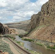
rail service. The route derives its name from its crossing of the Sierra Nevada Mountains, where it follows both the North and Middle Forks of the Feather River
Feather River
The Feather River is the principal tributary of the Sacramento River, in the Sacramento Valley of Northern California. The river's main stem is about long. Its length to its most distant headwater tributary is about . Its drainage basin is about...
. The route is famous for its impressive engineering qualities and its considerable scenic value. All of the route is now owned and operated by the Union Pacific Railroad
Union Pacific Railroad
The Union Pacific Railroad , headquartered in Omaha, Nebraska, is the largest railroad network in the United States. James R. Young is president, CEO and Chairman....
; however, the Union Pacific has transferred significant portions of the route to other lines. The portion still called the Feather River Route by the Union Pacific runs from the California Central Valley
California Central Valley
California's Central Valley is a large, flat valley that dominates the central portion of California. It is home to California's most productive agricultural efforts. The valley stretches approximately from northwest to southeast inland and parallel to the Pacific Ocean coast. Its northern half is...
to Winnemucca, Nevada
Winnemucca, Nevada
-Demographics:As of the census of 2000, there were 7,174 people, 2,736 households, and 1,824 families residing in the city. The population density was 867.5 people per square mile . There were 3,280 housing units at an average density of 396.6 per square mile...
.
History
Early history
Interest in building a transportation artery through the Feather River Canyon and across the deserts of NevadaNevada
Nevada is a state in the western, mountain west, and southwestern regions of the United States. With an area of and a population of about 2.7 million, it is the 7th-largest and 35th-most populous state. Over two-thirds of Nevada's people live in the Las Vegas metropolitan area, which contains its...
and Utah
Utah
Utah is a state in the Western United States. It was the 45th state to join the Union, on January 4, 1896. Approximately 80% of Utah's 2,763,885 people live along the Wasatch Front, centering on Salt Lake City. This leaves vast expanses of the state nearly uninhabited, making the population the...
began with the discovery of Beckwourth Pass
Beckwourth Pass
Beckwourth Pass is the lowest Sierra Crest mountain pass and is located at the Sierra Valley's eastern edge near Chilcoot-Vinton, Plumas County, California. Beckwourth Pass is east of Beckwourth, California, in the Sierra Nevada, and is northwest of Reno, Nevada. The pass carries California State...
, in the Sierra Nevada Mountains, in 1850. The pass, at 5221 feet (1,591.4 m) in elevation, is one of the lowest passes through the Sierras. In the 1860s, Arthur W. Keddie began surveying in the Feather River Canyon, in order to find a suitable route for such an artery. He eventually found such a route, and helped to found the Oroville and Virginia City Railroad Company in 1867 to build a railroad along it. However, political pressure from the Central Pacific Railroad
Central Pacific Railroad
The Central Pacific Railroad is the former name of the railroad network built between California and Utah, USA that formed part of the "First Transcontinental Railroad" in North America. It is now part of the Union Pacific Railroad. Many 19th century national proposals to build a transcontinental...
, among other factors, led to the end of all construction efforts by 1869.
Throughout the 1870s and 1880s, little progress was made in forming a company to construct the railroad line. Some interest remained, however, because the proposed route was much less steep and passed through the Sierras at a point 2000 feet (609.6 m) lower than that of the recently finished First Transcontinental Railroad
First Transcontinental Railroad
The First Transcontinental Railroad was a railroad line built in the United States of America between 1863 and 1869 by the Central Pacific Railroad of California and the Union Pacific Railroad that connected its statutory Eastern terminus at Council Bluffs, Iowa/Omaha, Nebraska The First...
, owned by the Central Pacific Railroad
Central Pacific Railroad
The Central Pacific Railroad is the former name of the railroad network built between California and Utah, USA that formed part of the "First Transcontinental Railroad" in North America. It is now part of the Union Pacific Railroad. Many 19th century national proposals to build a transcontinental...
between Sacramento
Sacramento, California
Sacramento is the capital city of the U.S. state of California and the county seat of Sacramento County. It is located at the confluence of the Sacramento River and the American River in the northern portion of California's expansive Central Valley. With a population of 466,488 at the 2010 census,...
and Ogden, Utah
Ogden, Utah
Ogden is a city in Weber County, Utah, United States. Ogden serves as the county seat of Weber County. The population was 82,825 according to the 2010 Census. The city served as a major railway hub through much of its history, and still handles a great deal of freight rail traffic which makes it a...
. The Union Pacific Railroad
Union Pacific Railroad
The Union Pacific Railroad , headquartered in Omaha, Nebraska, is the largest railroad network in the United States. James R. Young is president, CEO and Chairman....
, which terminated in Ogden
Ogden, Utah
Ogden is a city in Weber County, Utah, United States. Ogden serves as the county seat of Weber County. The population was 82,825 according to the 2010 Census. The city served as a major railway hub through much of its history, and still handles a great deal of freight rail traffic which makes it a...
at the time, postulated multiple times throughout this era about building the line, so that it could bypass the Central Pacific and access the Pacific Coast
Pacific Coast
A country's Pacific coast is the part of its coast bordering the Pacific Ocean.-The Americas:Countries on the western side of the Americas have a Pacific coast as their western border.* Geography of Canada* Geography of Chile* Geography of Colombia...
on its own. However, none of these proposals ever amounted to any level of action, and the idea was widely considered dead by the 1890s.
However, interest in a line through the Feather River Canyon was renewed in 1900, when the Union Pacific Railroad, then led by E. H. Harriman
E. H. Harriman
Edward Henry Harriman was an American railroad executive.-Early years:Harriman was born in Hempstead, New York, the son of Orlando Harriman, an Episcopal clergyman, and Cornelia Neilson...
, took control of the Southern Pacific Railroad
Southern Pacific Railroad
The Southern Pacific Transportation Company , earlier Southern Pacific Railroad and Southern Pacific Company, and usually simply called the Southern Pacific or Espee, was an American railroad....
. Subsequently, Harriman decided to close off access to the Southern Pacific to all railroads other than the Union Pacific, leaving all other railroads unable to access the Pacific Coast
Pacific Coast
A country's Pacific coast is the part of its coast bordering the Pacific Ocean.-The Americas:Countries on the western side of the Americas have a Pacific coast as their western border.* Geography of Canada* Geography of Chile* Geography of Colombia...
from Salt Lake City. Foremost among these railroads was the Denver and Rio Grande Western Railroad
Denver and Rio Grande Western Railroad
The Denver & Rio Grande Western Railroad , often shortened to Rio Grande or D&RGW, formerly the Denver & Rio Grande Railroad, is a defunct U.S. railroad company. The railroad started as a narrow gauge line running south from Denver, Colorado in 1870; however, served mainly as a transcontinental...
, the westernmost part of an 11000 miles (17,703 km) transcontinental rail network organized by Jay Gould
Jay Gould
Jason "Jay" Gould was a leading American railroad developer and speculator. He has long been vilified as an archetypal robber baron, whose successes made him the ninth richest American in history. Condé Nast Portfolio ranked Gould as the 8th worst American CEO of all time...
. Jay's son and successor, George Gould
George Jay Gould I
George Jay Gould I was a financier and the son of Jay Gould. He was himself a railroad executive, leading both the Denver and Rio Grande Western Railroad and the Western Pacific Railroad ....
, decided it prudent to regain access to the Pacific Coast. Hence, on April 3, 1903, the Western Pacific Railroad
Western Pacific Railroad
The Western Pacific Railroad was a Class I railroad in the United States. It was formed in 1903 as an attempt to break the near-monopoly the Southern Pacific Railroad had on rail service into northern California...
, backed heavily by Gould, was founded in San Francisco, California
San Francisco, California
San Francisco , officially the City and County of San Francisco, is the financial, cultural, and transportation center of the San Francisco Bay Area, a region of 7.15 million people which includes San Jose and Oakland...
.
Construction
Nevada
Nevada is a state in the western, mountain west, and southwestern regions of the United States. With an area of and a population of about 2.7 million, it is the 7th-largest and 35th-most populous state. Over two-thirds of Nevada's people live in the Las Vegas metropolitan area, which contains its...
and Utah
Utah
Utah is a state in the Western United States. It was the 45th state to join the Union, on January 4, 1896. Approximately 80% of Utah's 2,763,885 people live along the Wasatch Front, centering on Salt Lake City. This leaves vast expanses of the state nearly uninhabited, making the population the...
high temperature and lack of water made conditions similarly difficult; construction costs skyrocketed, nearly bankrupting the contractors building the line. Labor turnover was extremely high, due to the miserable working conditions. Nonetheless, progress inched further, although slower than anticipated, due to the challenges caused by the presence of many long tunnels on the Sierra portion of the route.
When the line was finished in 1909 it spanned a total of 927 miles (1,491.9 km), and had been built at the then ferociously expensive cost of $75 million (equivalent to $ million in ). It featured a ruling grade of 1%, making it only half as steep as Southern Pacific's
Southern Pacific Railroad
The Southern Pacific Transportation Company , earlier Southern Pacific Railroad and Southern Pacific Company, and usually simply called the Southern Pacific or Espee, was an American railroad....
Donner Pass
Donner Pass
Donner Pass is a mountain pass in the northern Sierra Nevada, located above Donner Lake about nine miles west of Truckee, California. It has a steep approach from the east and a gradual approach from the west....
line, its primary competitor.
History under the Western Pacific
Western Pacific Railroad
The Western Pacific Railroad was a Class I railroad in the United States. It was formed in 1903 as an attempt to break the near-monopoly the Southern Pacific Railroad had on rail service into northern California...
by the Union Pacific Railroad
Union Pacific Railroad
The Union Pacific Railroad , headquartered in Omaha, Nebraska, is the largest railroad network in the United States. James R. Young is president, CEO and Chairman....
in 1983. Between 1909 and 1918, traffic rose with the onset of World War I
World War I
World War I , which was predominantly called the World War or the Great War from its occurrence until 1939, and the First World War or World War I thereafter, was a major war centred in Europe that began on 28 July 1914 and lasted until 11 November 1918...
, although such gains vanished in the 1920s and 1930s. The construction of the "Inside Gateway" line, completed in 1931 between Keddie
Keddie, California
Keddie is a census-designated place in Plumas County, California, United States. The population was 66 at the 2010 census.-Geography:Keddie is located at ....
and Bieber, California
Bieber, California
Bieber is a census-designated place in Lassen County, California. It is located on the Pit River north-northwest of Susanville, at an elevation of 4124 feet . Its population was 312 at the 2010 census. The ZIP Code is 96009. The community is inside area code 530.-History:The settlement sprang up...
, failed to alleviate the problem. Yet in 1936, in spite of falling traffic, the Western Pacific rehabilitated the Feather River Route using RFC
Reconstruction Finance Corporation
The Reconstruction Finance Corporation was an independent agency of the United States government, established and chartered by the US Congress in 1932, Act of January 22, 1932, c. 8, 47 Stat. 5, during the administration of President Herbert Hoover. It was modeled after the War Finance Corporation...
funds. As a result, the line was in optimal condition at the onset of World War II
World War II
World War II, or the Second World War , was a global conflict lasting from 1939 to 1945, involving most of the world's nations—including all of the great powers—eventually forming two opposing military alliances: the Allies and the Axis...
in 1939.
Traffic levels on the route exploded during the first year of the war. Freight traffic doubled, and passenger traffic increased sixfold. Traffic increased steadily in both categories over the next few years of the war. In response to this, the Western Pacific installed Centralized Traffic Control
Centralized traffic control
Centralized traffic control is a form of railway signalling that originated in North America and centralizes train routing decisions that were previously carried out by local signal operators or the train crews themselves. The system consists of a centralized train dispatcher's office that...
between Oroville
Oroville, California
Oroville is the county seat of Butte County, California. The population was 15,506 at the 2010 census, up from 13,004 at the 2000 census...
and Portola, California
Portola, California
Portola is the only incorporated city in Plumas County, California, United States. The population was 2,104 at the 2010 census, down from 2,227 at the 2000 census...
, in the Sierra Nevada, during 1944 and 1945.
From the late 1940s through to the early 1970s, freight traffic on the line grew slowly, while passenger traffic fell substantially. However, this did not stop the Western Pacific from introducing the California Zephyr
California Zephyr
The California Zephyr is a long passenger train route operated by Amtrak in the midwestern and western United States.It runs from Chicago, Illinois, in the east to Emeryville, California, in the west, passing through the states of Illinois, Iowa, Nebraska, Colorado, Utah, Nevada, and California...
in 1949. The Zephyr, which operated over three railroads on its route between Oakland
Oakland, California
Oakland is a major West Coast port city on San Francisco Bay in the U.S. state of California. It is the eighth-largest city in the state with a 2010 population of 390,724...
and Chicago
Chicago
Chicago is the largest city in the US state of Illinois. With nearly 2.7 million residents, it is the most populous city in the Midwestern United States and the third most populous in the US, after New York City and Los Angeles...
, gained immense recognition but failed to last past the year 1970, when lack of riders and unprofitability forced the Western Pacific to abandon the service.
In 1957, a portion of the route between Oroville and Intake had to be relocated to make way for the Oroville Dam
Oroville Dam
Oroville Dam spans the Feather River about northeast of the city of Oroville, California. It forms Lake Oroville, which stores water for irrigation, flood control, municipal water supply and hydroelectricity generation in California's Sacramento Valley. The dam lies in the foothills of the Sierra...
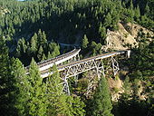
. The new line features the North Fork Bridge, which is 1000 feet (304.8 m) long and 200 feet (61 m) high. The line began operation in 1962. During the 1970s, the Feather River Route experienced modernization, as operations became computerized.
Shared trackage agreement
The Feather River Route parallels the Overland RouteOverland Route (Union Pacific Railroad)
The Overland Route was a train route operated jointly by the Union Pacific Railroad and the Central Pacific Railroad / Southern Pacific Railroad, between Council Bluffs, Iowa / Omaha, Nebraska, and San Francisco, California over the grade of the First Transcontinental Railroad which had been...
in central Nevada between Weso (near Winnemucca
Winnemucca, Nevada
-Demographics:As of the census of 2000, there were 7,174 people, 2,736 households, and 1,824 families residing in the city. The population density was 867.5 people per square mile . There were 3,280 housing units at an average density of 396.6 per square mile...
) and Alazon (near Wells
Wells, Nevada
Wells is a city in Elko County, in northeast Nevada in the western United States. The population was 1,346 at the 2000 census. Wells is located at the junction of U.S. Route 93 and Interstate 80, approximately east of Elko and is part of the Elko Micropolitan Statistical Area.-History:The site...
). The Southern Pacific Railroad
Southern Pacific Railroad
The Southern Pacific Transportation Company , earlier Southern Pacific Railroad and Southern Pacific Company, and usually simply called the Southern Pacific or Espee, was an American railroad....
and Western Pacific came to a shared trackage agreement to use directional running. Eastbound trains of both companies used the tracks for the Feather River Route while westbound trains used the Overland Route. In the shared track area, the tracks mostly run on opposite sides of the Humboldt River
Humboldt River
The Humboldt River runs through northern Nevada in the western United States. At approximately long it is the second longest river in the Great Basin, after the Bear River. It has no outlet to the ocean, but instead empties into the Humboldt Sink...
; at some points the two lines are several miles apart. There is one grade separated crossing of the two lines near Palisade, Nevada
Palisade, Nevada
Palisade is located in Eureka County in the northeastern section of the state of Nevada, in the western United States. It is about 10 miles south of Carlin, and about 27 miles southwest of Elko. Although now a virtual ghost town, it had a rich history following construction of the...
. For the shared track agreement, crossovers were constructed where the lines run in close proximity to allow bi-directional service to the areas previously only accessible from one of the lines, such as Battle Mountain
Battle Mountain, Nevada
Battle Mountain is an unincorporated community and census-designated place in Lander County, Nevada, United States. The population was 2,871 at the 2000 census. Though it has no legal status as a municipality, it still functions as the county seat of Lander County...
.
Present
The Western Pacific was purchased by the Union Pacific RailroadUnion Pacific Railroad
The Union Pacific Railroad , headquartered in Omaha, Nebraska, is the largest railroad network in the United States. James R. Young is president, CEO and Chairman....
in 1983. In 1996, the Union Pacific acquired the Southern Pacific, resulting in both lines between Oakland and Utah being owned by the same company. After the acquisition, the Union Pacific truncated the Feather River Route to the meeting points of the two lines near Sacramento, California
Sacramento, California
Sacramento is the capital city of the U.S. state of California and the county seat of Sacramento County. It is located at the confluence of the Sacramento River and the American River in the northern portion of California's expansive Central Valley. With a population of 466,488 at the 2010 census,...
and Winnemucca, Nevada. East of Winnemucca, the former Feather River Route has been combined with lines from the former Denver and Rio Grande Western Railroad
Denver and Rio Grande Western Railroad
The Denver & Rio Grande Western Railroad , often shortened to Rio Grande or D&RGW, formerly the Denver & Rio Grande Railroad, is a defunct U.S. railroad company. The railroad started as a narrow gauge line running south from Denver, Colorado in 1870; however, served mainly as a transcontinental...
to form the Central Corridor
Central Corridor (Union Pacific Railroad)
The Central Corridor is a rail line operated by the Union Pacific Railroad from near Winnemucca, Nevada to Denver, Colorado in the western United States. The line is in use for freight, and provides the route of the California Zephyr. The BNSF Railway has trackage rights on the entire line. The...
. The far western portion of the line, between Niles and Stockton
Stockton, California
Stockton, California, the seat of San Joaquin County, is the fourth-largest city in the Central Valley of the U.S. state of California. With a population of 291,707 at the 2010 census, Stockton ranks as this state's 13th largest city...
is now used by the Altamont Commuter Express
Altamont Commuter Express
The Altamont Commuter Express is a regional rail service in California connecting Stockton with San Jose....
. The Western Pacific Railroad Museum
Western Pacific Railroad Museum
The Western Pacific Railroad Museum in Portola, California, formerly known as the Portola Railroad Museum before , is a heritage railroad that preserves and operates historic American railroad equipment. The museum's mission is to preserve the history of the Western Pacific Railroad and is...
, a preservation society founded in 1984, is located next to the Union Pacific rail yard in Portola, California
Portola, California
Portola is the only incorporated city in Plumas County, California, United States. The population was 2,104 at the 2010 census, down from 2,227 at the 2000 census...
. Most of the remaining portion of the Feather River Route follows State Route 70 in California and former State Route 49 in Nevada.
Points of interest
- Lake OrovilleLake OrovilleLake Oroville, also known as Lake Edmonston, is a reservoir in the U.S. state of California, formed by the Oroville Dam across the Feather River. The lake is situated in the foothills of the Sierra Nevada about northeast of Oroville. At over , it is one of the largest reservoirs in California,...
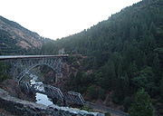
- Tobin Bridges
- Keddie WyeKeddie WyeThe Keddie Wye is a favorite railfan spot at a wye along the Feather River Route, located at Keddie, California, named after Arthur Keddie. Mr. Keddie purchased the survey rights and the right to build a railroad through the Feather River Canyon from George Jay Gould I, the son of Jay Gould...
- North Fork Bridge
- Williams LoopWilliams LoopThe Williams Loop is a rail spiral located on the Union Pacific Railroad's Feather River Route through the Sierra Nevada Mountains in north eastern California, connecting the Sacramento Valley to Salt Lake City via the Feather River valley...
- Spring Garden TunnelSpring Garden TunnelThe Spring Garden Tunnel at in Spring Garden, California is the longest of 34 tunnels of the Feather River Route The Spring Garden Tunnel at in Spring Garden, California is the longest of 34 tunnels of the Feather River Route The Spring Garden Tunnel at in Spring Garden, California is the...
- Clio trestleClio trestleThe Clio Trestle, a historic Feather River Route railroad trestle, is a favorite railfan spot located in the Sierra Nevada near Clio, in Plumas County, California...
- Beckwourth PassBeckwourth PassBeckwourth Pass is the lowest Sierra Crest mountain pass and is located at the Sierra Valley's eastern edge near Chilcoot-Vinton, Plumas County, California. Beckwourth Pass is east of Beckwourth, California, in the Sierra Nevada, and is northwest of Reno, Nevada. The pass carries California State...
- Black Rock DesertBlack Rock DesertThe Black Rock Desert is an arid region in the northern Nevada section of the Great Basin with a lakebed that is a dry remnant of Pleistocene Lake Lahontan...
Along portions built as part of the Feather River Route that are currently assigned to other lines:
- Niles CanyonNiles CanyonNiles Canyon is a canyon in the San Francisco Bay Area formed by Alameda Creek. The canyon is largely in an unincorporated area of Alameda County, while the western portion of the canyon lies within the city limits of Fremont and Union City...
- Altamont PassAltamont PassAltamont Pass, formerly Livermore Pass, is a mountain pass in the Diablo Range between Livermore in the Livermore Valley and Tracy in the San Joaquin Valley in Northern California...
- Carlin TunnelCarlin TunnelThe Carlin Tunnel is a collective name for a set of four tunnel bores east of Carlin, in Elko County, Nevada, USA. Each of the four bores was constructed for a different purpose and at a different time. Currently, two of the bores carry Interstate 80 through a canyon wall to bypass bends in the...
- Flower Pass tunnelPequop MountainsThe Pequop Mountains are located in eastern Elko County, in northeastern Nevada in the western United States. The range runs generally north-south for approximately 51 miles...
- Arnold Loop/Silver Zone PassToano RangeThe Toano Range is a group of mountains located in the eastern part of Elko County, in the northeastern section of the state of Nevada in the Great Basin region of the western United States. The highest point in the range reaches ....
- Bonneville Salt Flats
- Saltair ResortSaltair, UtahSaltair, also The SaltAir or Saltair Pavilion, is the name which has been given to several resorts located on the southern shore of the Great Salt Lake in Utah, United States, about fifteen miles from Salt Lake City.-Saltair I:...