
Cound
Encyclopedia
Cound is a village and civil parish on the west bank of the River Severn
in the English
county of Shropshire
, 6.7 miles (10.8 kilometres) south east of the county town
Shrewsbury
. Once a busy and industrious river port Cound has now reverted back to a quiet rural community and dormitory village, for commuters to the commercial centres of Shrewsbury and Telford
.
Locally the village name is pronounced "COOnd" (rhymes with boomed or doomed) although those local residents who have Cound as their surname usually pronounce it as "COWnd" (rhymes with pound or hound.)
Whilst occupying a relatively large area, the parish is actually made up of four much smaller communities. Coundarbour, a dispersed group of dwellings located just off the A458 road, Cound and Upper Cound all relatively closely together, but with Cound Moor set some 3 km further south. Cound is a very small collection of dwellings and farms. The northern half of Cound with the church and Cound Hall are within a designated Area of Special Landscape Character and Coundmoor is a linear collection of dwellings and bungalows on the back road to Harnage Grange and Acton Burnell
. There are 68 buildings, monuments, bridges, walls and milestones carrying Listed building status within the village. Most are Grade II with only Cound Hall and the church as Grade I.
, Caer Caradoc in the Stretton Hills and on The Wrekin
. The 1st century Roman legionary fortress at Uriconium
, only a mile and half distant, was one of the largest towns in Roman Britain and the Romans exploited silver-bearing lead ores and outcrop coal on the Shropshire plains.
During the warmer and milder weather of the Iron Age, the Roman period and into the early medieval period Cound remained important as a busy crossing point for the River Severn, as the lower rainfalls meant that the river flow was much less than it is today. The several meanders at Cound created ideal slow running and shallow fording points. An important roman road has been identified as passing through Cound on its way to Uriconium and once provided a route for Roman soldiers travelling to or from another major fortified settlement at Isca Augusta (modern day Caerleon)
or into the Welsh Marches
.
Remains have been identified in Cound of a Roman marching camp that may predate Uriconium. Only the eastern corner-angle, a short length of the north-east side and a longer piece of the south-eastern defence ditch of this camp have been excavated. The only gap in the identified rampart occurs at a point where the underlying geology is suspect and this has not yet been positively identified as a gateway. However there are suggestions that the north-westerly side would not have been much over 180m distant from the south-eastern ramparts. The location of the missing south-west extremity has not yet been found. At certain times of the year and in particular weather conditions aerial photographs identify multiple crop marks of many extensive rectangular structures all over the Cound village area, particularly Upper Cound, that are probably Roman buildings such as villas, high status farmhouses, or military fortifications.
and game hunting grounds under special jurisdiction of a Shire reeve
, or Sheriff
as they came to be known. Although game was hunted throughout the Shropshire Long Forest, as it was called, there is documentary evidence that Cound was a special hunting reserve for the Norman royalty. A T Gaydon B Ed reported in Victoria County History 8: Condover and Ford Hundreds (1968) that:-
In the 13th century the high quality of Shropshire wool brought prosperity to Ludlow, Shrewsbury, and Bridgnorth, as the main centres. Shrewsbury in particular became the principal market for an extensive area including much of North Wales and the Shropshire plains. The original Cound Manor House is thought to have been built around this time. The farm buildings of the present Cound Hall lie just to the south of the walled kitchen garden and are believed to be standing on the site of the first medieval manor house. If this identification is correct the farm buildings may represent part of the surviving plan elements of the earlier manorial enclosure. They would have stood on the then main road, with the manor house set back to the north behind them.
in 1797, and remains the oldest iron bridge still in everyday use anywhere in the world. The confluence of the Severn and the Cound Brook is upstream of Ironbridge Gorge
and it is not surprising that when Telford, then Road Engineer to Shropshire County, designed two bridges to cross the brook he also used the familiar local industry to build them. The Coundarbour bridge with its stone buttresses is found by approaching Cound along the A458.
Telford's second and much later bridge across the Cound Brook, the Cantlop bridge
is a few miles away, built in 1820 and no longer in use but maintained as a monument by English Heritage
.
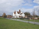
 The current manor house of Cound Hall is a Grade I listed building and a large vernacular Baroque
house, with a basement and two storeys of tall slender windows topped by a half-storey, built of red brick with stone dressings. The house was built in 1703-04 for Edward Cressett by a John Prince. Historian Howard Colvin in his book A Biographical Dictionary of British Architects, 1600–1840, 3rd ed. 1995, p 781, suggests that this Prince is the same John Prince of Shrewsbury who acted as agent and surveyor to Edward Harley in the designing of the Harley estate in Marylebone
, London
.
The house is most notable for its large stop-fluted Corinthian
pilaster
s with richly carved capitals
, which have been described as "ambitious but inept" and suggestions are that the inspiration was the King William block at Greenwich Hospital that was designed by Christopher Wren
.
One outstanding feature of the interior is the staircase, a fascinating alteration which has been dated to the late 18th century. The concept of the staircase was to gain more room where the original staircase had been, thus creating a feeling of greater space in the hallway. The staircase has a delicate metal handrail and runs through both storeys along three sides of an open well. The staircase rests on two beautiful fluted columns. There is light Neo-Elizabethan
plaster work on the underside of the staircase.
There is a Grade II listed dovecote built in the 18th century and still standing in the grounds of the hall. The dovecote was originally sited as the main focus at the end of the grand entrance driveway.
Ownership of Cound Hall passed from the Cressett family to the Thursby-Pelham family by marriage and inheritance; then to the McCorquodale family - into which the young Barbara Cartland married; she lived at the Hall for some years in the late 1920s/early 30's whilst married to Alexander McCorquodale.
In the 1960s, the then owner (Morris) divided the house into rented flats, and it was tenanted in this way until the 1980s, as gradually the building deteriorated & the tenants left.
The hall then stood empty and derelict for many years,.until the current owners (the Waller family) bought the house as a virtual wreck in 1996 with the intention of restoring it.
In 2004 it featured in the BBC TV programme, "Restoration
" but was unsuccessful in the public competition for funds to renovate the building. English Heritage
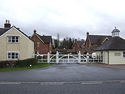
was most concerned about the building's continuing deterioration at that time, and placed the Hall on its At risk register. However, through building a new estate of houses, inside the gatehouse entrance on the east side of the estate, they raised sufficient funds to rescue the house; and the Hall is now almost fully restored (2008) and is inhabited as a family house once again.
at Upper Cound from the 18th century until the late 1960s specialising in coal exports by barge along the river to the industrial centres of the West Midlands and the coal exporting ports at Bristol
, Cardiff
and Penarth
. Goods and coal arrived at the small port initially by horse drawn carts and later by rail. The port and railway have since been removed although the small cove inlet that formed the wharf can still be seen.
What is now the Riverside Inn faced the river port and associated railway and was originally the Cound halt on a continuation of the Severn Valley Railway
from Ironbridge to Shrewsbury. Cound station was half way between the stations at Cressage
and Berrington
at the point where the railway skirted adjacent to the River Severn. The building of the railway line and station commenced in 1858 and opened for trade in 1862 but never handled much in the way of passengers, mostly specialising in freight traffic. Mainly wool skeins, agricultural produce and specifically coal, from the busy collieries of Alveley
and Highley
, were the principal sources of revenue at Cound. The railway was closed in 1963 as an early casualty of the Beeching Axe
.
The station stood vacant for several years before being converted to a hotel and public house and renamed the Cound Lodge Inn. That establishment closed several years ago and again stood empty until it was renovated and reopened as the Riverside Inn. The railway tracks have long been removed but, because the original station faced the river and railway line, the building now stands with its back to the modern A458 roadway that now mainly services it. The Inn does however retain a passing summer trade of leisure boatsmen and canoeists on the river.
After lengthy negotiations with English Heritage and local planning authorities several high value executive houses have been built in the Hall's grounds with a secure gated entrance between the estate's original gatehouses.
, which allowed Daniel Kawczynski
of the Conservatives
to be elected as MP for Shrewsbury and Atcham with a majority of 1,808.
and at the northern end of the Shropshire-Severn plain. The various settlements that make up the village are bisected by the Cound Brook
, sometimes called the Coundmoor Brook, an important local tributary of the River Severn, which rises in the Stretton Hills near Caer Caradoc some fifteen miles distant to the south west, although the many meanders of the brook entails a passage of closer to twenty five miles before its confluence near Eyton on Severn
.
The sediments that make up Coundmoor and the flood plain were laid down under a vast warm ocean, surrounded by many volcanoes that were ground down by later ice age
glaciers, around 18,000 years ago, which provided the fertile soil that contributed to Cound becoming a successful farming community throughout medieval times. The soils have been further enriched through regular flooding by the Severn and the Cound Brook, depositing enriched silts. There are still several active geological fault lines underlying the area and on 2 April 1990 Cound experienced an earthquake, measuring 5.4 on the Richter Scale, that was centred on nearby Bishop's Castle
.
The village lies just six miles south east of Shrewsbury
and is separated from the county town
by the main A5 Trunk road
. It has good road transport links with easy access to both the A49
and A5. To the west lies the pre-cambrian Lyth Hill, with Sharpstone Hill standing to the north west, the latter now mostly a major sandstone quarry with little of the hill itself now remaining after several hundred years of constant quarrying activities.
that the bones of a Woolly mammoth
were discovered in 1986. The skeleton is still one of the most complete mammoth skeletons ever to be found in the UK and has been dated at 12,700 years old, making it one of the last surviving mammoths in England. There is a model of the Condover mammoth skeleton at the Shropshire Hills Discovery Centre in Craven Arms
, along with a reconstruction of how it might have lived. Adjacent to Bomere Pool is a secluded traditional forest of around 125 acres (0.51 km2), woodland that once formed part of Bayston Hill and Condover Royal hunting forest
.
Cound's own gravel sink hole pit is now established as a lake fed by its own spring source and is run as the commercial Cound Trout Fishery, occupying a redundant quarry works alongside the main road.
or Condover Primary School, a Church of England
coeducational school currently with 109 pupils on roll aged between 5 and 11.
, Much Wenlock
or Church Stretton
and the sixth form college in Shrewsbury.
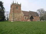 The Anglican St Peter's Church is Grade I listed, standing in the grounds of Cound Hall and was maintained as a family chapel by the various Lords of the Manor. A wooded avenue was constructed as a walkway across the grounds from Cound Hall to the church in the mid 19th century. Archeological fieldwork in 1990 identified the possible remains of the now severely eroded causeway associated with it.
The church structure mostly dates from the mid 14th century but has several later additions, right up to the north aisle and chancel that have been dated to the Victorian era
. The font however has been confirmed as being original Norman and has probably been in place since the church was first built.
There are many funerary monuments and grave markings in the churchyard that have been granted Listed status in their own right. Most of the church is constructed with a smooth pink sandstone quarried locally at Berriewood.
As of 2008 Cound CC field 2 teams in the shropshire cricket league, the 1st playing in Division 1 and the 2nd XI winning promotion to division 3. The club also has as a mid-week team, and a thriving junior section. The club has recently improved facilities with the addition of new changing facilities in August 2006. In the season practice nights are on a Monday for the seniors and Thursday's for the juniors.
but was unsuccessful in the public competition for funds to renovate the building. Fortunately, funds were subsequently raised by building new houses within the grounds of the hall and it has been now almost fully restored & is inhabited once again.
Cound Hall also featured in one-off BBC feature Fast Show special, Ted and Ralph in December 1998, where it starred as Ralph's ancestral home.
In 2010, 2 episodes of the BBC programme "Songs of Praise" were recorded from the church of St. Peter in Cound. One episode (broadcast in December 2010) saw the church and congregation in Edwardian dress and featured an Edwardian themed Christmas concert. The second episode (due to be broadcast in Lent 2011) sees the church in a more modern light with an "up-to-date" service.
between 1748 and 1754 (Jonathan Humphries, Cound Hall Past and Present, 1989).
River Severn
The River Severn is the longest river in Great Britain, at about , but the second longest on the British Isles, behind the River Shannon. It rises at an altitude of on Plynlimon, Ceredigion near Llanidloes, Powys, in the Cambrian Mountains of mid Wales...
in the English
England
England is a country that is part of the United Kingdom. It shares land borders with Scotland to the north and Wales to the west; the Irish Sea is to the north west, the Celtic Sea to the south west, with the North Sea to the east and the English Channel to the south separating it from continental...
county of Shropshire
Shropshire
Shropshire is a county in the West Midlands region of England. For Eurostat purposes, the county is a NUTS 3 region and is one of four counties or unitary districts that comprise the "Shropshire and Staffordshire" NUTS 2 region. It borders Wales to the west...
, 6.7 miles (10.8 kilometres) south east of the county town
County town
A county town is a county's administrative centre in the United Kingdom or Ireland. County towns are usually the location of administrative or judicial functions, or established over time as the de facto main town of a county. The concept of a county town eventually became detached from its...
Shrewsbury
Shrewsbury
Shrewsbury is the county town of Shropshire, in the West Midlands region of England. Lying on the River Severn, it is a civil parish home to some 70,000 inhabitants, and is the primary settlement and headquarters of Shropshire Council...
. Once a busy and industrious river port Cound has now reverted back to a quiet rural community and dormitory village, for commuters to the commercial centres of Shrewsbury and Telford
Telford
Telford is a large new town in the borough of Telford and Wrekin and ceremonial county of Shropshire, England, approximately east of Shrewsbury, and west of Birmingham...
.
Locally the village name is pronounced "COOnd" (rhymes with boomed or doomed) although those local residents who have Cound as their surname usually pronounce it as "COWnd" (rhymes with pound or hound.)
Whilst occupying a relatively large area, the parish is actually made up of four much smaller communities. Coundarbour, a dispersed group of dwellings located just off the A458 road, Cound and Upper Cound all relatively closely together, but with Cound Moor set some 3 km further south. Cound is a very small collection of dwellings and farms. The northern half of Cound with the church and Cound Hall are within a designated Area of Special Landscape Character and Coundmoor is a linear collection of dwellings and bungalows on the back road to Harnage Grange and Acton Burnell
Acton Burnell
Acton Burnell is a village and parish in the English county of Shropshire. It lies at 110m above sea level and is near to Park Wood.-Attractions:...
. There are 68 buildings, monuments, bridges, walls and milestones carrying Listed building status within the village. Most are Grade II with only Cound Hall and the church as Grade I.
Prehistoric and Roman
Cound has been occupied since the Late Neolithic and Early Bronze Age and small artifacts from these periods have been discovered in considerable numbers. Early Iron Age bivillate hill forts survive nearby at Bayston HillBayston Hill
Bayston Hill is a large village and civil parish in central Shropshire, England. It is south of the county town Shrewsbury and located on the main A49 road, the Shrewsbury to Hereford road....
, Caer Caradoc in the Stretton Hills and on The Wrekin
The Wrekin
The Wrekin is a hill in east Shropshire, England. It is located some west of Telford, on the border between the unitary authorities of Shropshire and Telford and Wrekin. Rising to a height of above the Shropshire Plain, it is a prominent and well-known landmark, marking the entrance to Shropshire...
. The 1st century Roman legionary fortress at Uriconium
Wroxeter
Wroxeter is a village in Shropshire, England. It forms part of the civil parish of Wroxeter and Uppington and is located in the Severn Valley about south-east of Shrewsbury.-History:...
, only a mile and half distant, was one of the largest towns in Roman Britain and the Romans exploited silver-bearing lead ores and outcrop coal on the Shropshire plains.
During the warmer and milder weather of the Iron Age, the Roman period and into the early medieval period Cound remained important as a busy crossing point for the River Severn, as the lower rainfalls meant that the river flow was much less than it is today. The several meanders at Cound created ideal slow running and shallow fording points. An important roman road has been identified as passing through Cound on its way to Uriconium and once provided a route for Roman soldiers travelling to or from another major fortified settlement at Isca Augusta (modern day Caerleon)
Isca Augusta
Isca Augusta was a Roman legionary fortress and settlement, the remains of which lie beneath parts of the present-day village of Caerleon on the northern outskirts of the city of Newport in South Wales.-Name:...
or into the Welsh Marches
Welsh Marches
The Welsh Marches is a term which, in modern usage, denotes an imprecisely defined area along and around the border between England and Wales in the United Kingdom. The precise meaning of the term has varied at different periods...
.
Remains have been identified in Cound of a Roman marching camp that may predate Uriconium. Only the eastern corner-angle, a short length of the north-east side and a longer piece of the south-eastern defence ditch of this camp have been excavated. The only gap in the identified rampart occurs at a point where the underlying geology is suspect and this has not yet been positively identified as a gateway. However there are suggestions that the north-westerly side would not have been much over 180m distant from the south-eastern ramparts. The location of the missing south-west extremity has not yet been found. At certain times of the year and in particular weather conditions aerial photographs identify multiple crop marks of many extensive rectangular structures all over the Cound village area, particularly Upper Cound, that are probably Roman buildings such as villas, high status farmhouses, or military fortifications.
A medieval forest
Some of the crop marks however may be indicating the remains of later medieval hunting lodges. After the Norman Conquest of 1066, most of southern Shropshire, including the manor of Cound, was set aside as a Royal forestRoyal forest
A royal forest is an area of land with different meanings in England, Wales and Scotland; the term forest does not mean forest as it is understood today, as an area of densely wooded land...
and game hunting grounds under special jurisdiction of a Shire reeve
Reeve (England)
Originally in Anglo-Saxon England the reeve was a senior official with local responsibilities under the Crown e.g. as the chief magistrate of a town or district...
, or Sheriff
Sheriff
A sheriff is in principle a legal official with responsibility for a county. In practice, the specific combination of legal, political, and ceremonial duties of a sheriff varies greatly from country to country....
as they came to be known. Although game was hunted throughout the Shropshire Long Forest, as it was called, there is documentary evidence that Cound was a special hunting reserve for the Norman royalty. A T Gaydon B Ed reported in Victoria County History 8: Condover and Ford Hundreds (1968) that:-
- "Several historical records have identified a deer park of medieval dates in Cound, between 1066 and 1499, within the Royal Forest. It was probably formed soon after 1254 when a 'grant of free warren' was enacted and was still in operation in 1298. The medieval hunting park included stocks of free ranging deer together with wild boar and seems to have lain in the area of Longdale Coppice, north of the present day Cound Hall and the main road near the western banks of the River Severn."
In the 13th century the high quality of Shropshire wool brought prosperity to Ludlow, Shrewsbury, and Bridgnorth, as the main centres. Shrewsbury in particular became the principal market for an extensive area including much of North Wales and the Shropshire plains. The original Cound Manor House is thought to have been built around this time. The farm buildings of the present Cound Hall lie just to the south of the walled kitchen garden and are believed to be standing on the site of the first medieval manor house. If this identification is correct the farm buildings may represent part of the surviving plan elements of the earlier manorial enclosure. They would have stood on the then main road, with the manor house set back to the north behind them.
Iron bridges
The village of Cound is split in two by the Coundmoor Brook and the earliest part of the village is deemed to be where the church still stands. Coundarbour bridge was built over the brook by the renowned engineer Thomas TelfordThomas Telford
Thomas Telford FRS, FRSE was a Scottish civil engineer, architect and stonemason, and a noted road, bridge and canal builder.-Early career:...
in 1797, and remains the oldest iron bridge still in everyday use anywhere in the world. The confluence of the Severn and the Cound Brook is upstream of Ironbridge Gorge
Ironbridge Gorge
The Ironbridge Gorge is a deep gorge formed by the River Severn in Shropshire, England.Originally called the Severn Gorge, the gorge now takes its name from its famous Iron Bridge, the first iron bridge of its kind in the world, and a monument to the industry that began there...
and it is not surprising that when Telford, then Road Engineer to Shropshire County, designed two bridges to cross the brook he also used the familiar local industry to build them. The Coundarbour bridge with its stone buttresses is found by approaching Cound along the A458.
Telford's second and much later bridge across the Cound Brook, the Cantlop bridge
Cantlop
Cantlop is a small village in the English county of Shropshire. It is part of the civil parish of Berrington. Various meanings have been suggested for the name, such as an enclosed or cut-off valley or an enclosure in a waste or common....
is a few miles away, built in 1820 and no longer in use but maintained as a monument by English Heritage
English Heritage
English Heritage . is an executive non-departmental public body of the British Government sponsored by the Department for Culture, Media and Sport...
.
Cound Hall
Baroque
The Baroque is a period and the style that used exaggerated motion and clear, easily interpreted detail to produce drama, tension, exuberance, and grandeur in sculpture, painting, literature, dance, and music...
house, with a basement and two storeys of tall slender windows topped by a half-storey, built of red brick with stone dressings. The house was built in 1703-04 for Edward Cressett by a John Prince. Historian Howard Colvin in his book A Biographical Dictionary of British Architects, 1600–1840, 3rd ed. 1995, p 781, suggests that this Prince is the same John Prince of Shrewsbury who acted as agent and surveyor to Edward Harley in the designing of the Harley estate in Marylebone
Marylebone
Marylebone is an affluent inner-city area of central London, located within the City of Westminster. It is sometimes written as St. Marylebone or Mary-le-bone....
, London
London
London is the capital city of :England and the :United Kingdom, the largest metropolitan area in the United Kingdom, and the largest urban zone in the European Union by most measures. Located on the River Thames, London has been a major settlement for two millennia, its history going back to its...
.
The house is most notable for its large stop-fluted Corinthian
Corinthian order
The Corinthian order is one of the three principal classical orders of ancient Greek and Roman architecture. The other two are the Doric and Ionic. When classical architecture was revived during the Renaissance, two more orders were added to the canon, the Tuscan order and the Composite order...
pilaster
Pilaster
A pilaster is a slightly-projecting column built into or applied to the face of a wall. Most commonly flattened or rectangular in form, pilasters can also take a half-round form or the shape of any type of column, including tortile....
s with richly carved capitals
Capital (architecture)
In architecture the capital forms the topmost member of a column . It mediates between the column and the load thrusting down upon it, broadening the area of the column's supporting surface...
, which have been described as "ambitious but inept" and suggestions are that the inspiration was the King William block at Greenwich Hospital that was designed by Christopher Wren
Christopher Wren
Sir Christopher Wren FRS is one of the most highly acclaimed English architects in history.He used to be accorded responsibility for rebuilding 51 churches in the City of London after the Great Fire in 1666, including his masterpiece, St. Paul's Cathedral, on Ludgate Hill, completed in 1710...
.
One outstanding feature of the interior is the staircase, a fascinating alteration which has been dated to the late 18th century. The concept of the staircase was to gain more room where the original staircase had been, thus creating a feeling of greater space in the hallway. The staircase has a delicate metal handrail and runs through both storeys along three sides of an open well. The staircase rests on two beautiful fluted columns. There is light Neo-Elizabethan
Jacobethan
Jacobethan is the style designation coined in 1933 by John Betjeman to describe the mixed national Renaissance revival style that was made popular in England from the late 1820s, which derived most of its inspiration and its repertory from the English Renaissance , with elements of Elizabethan and...
plaster work on the underside of the staircase.
There is a Grade II listed dovecote built in the 18th century and still standing in the grounds of the hall. The dovecote was originally sited as the main focus at the end of the grand entrance driveway.
Ownership of Cound Hall passed from the Cressett family to the Thursby-Pelham family by marriage and inheritance; then to the McCorquodale family - into which the young Barbara Cartland married; she lived at the Hall for some years in the late 1920s/early 30's whilst married to Alexander McCorquodale.
In the 1960s, the then owner (Morris) divided the house into rented flats, and it was tenanted in this way until the 1980s, as gradually the building deteriorated & the tenants left.
The hall then stood empty and derelict for many years,.until the current owners (the Waller family) bought the house as a virtual wreck in 1996 with the intention of restoring it.
In 2004 it featured in the BBC TV programme, "Restoration
Restoration (TV series)
Restoration, Restoration, Restoration is a set of BBC television series where viewers decided on which listed building that was in immediate need of remedial works was to win a grant from Heritage Lottery Fund...
" but was unsuccessful in the public competition for funds to renovate the building. English Heritage
English Heritage
English Heritage . is an executive non-departmental public body of the British Government sponsored by the Department for Culture, Media and Sport...
was most concerned about the building's continuing deterioration at that time, and placed the Hall on its At risk register. However, through building a new estate of houses, inside the gatehouse entrance on the east side of the estate, they raised sufficient funds to rescue the house; and the Hall is now almost fully restored (2008) and is inhabited as a family house once again.
A river port and railway
There was a small port or wharf on the River SevernRiver Severn
The River Severn is the longest river in Great Britain, at about , but the second longest on the British Isles, behind the River Shannon. It rises at an altitude of on Plynlimon, Ceredigion near Llanidloes, Powys, in the Cambrian Mountains of mid Wales...
at Upper Cound from the 18th century until the late 1960s specialising in coal exports by barge along the river to the industrial centres of the West Midlands and the coal exporting ports at Bristol
Bristol
Bristol is a city, unitary authority area and ceremonial county in South West England, with an estimated population of 433,100 for the unitary authority in 2009, and a surrounding Larger Urban Zone with an estimated 1,070,000 residents in 2007...
, Cardiff
Cardiff
Cardiff is the capital, largest city and most populous county of Wales and the 10th largest city in the United Kingdom. The city is Wales' chief commercial centre, the base for most national cultural and sporting institutions, the Welsh national media, and the seat of the National Assembly for...
and Penarth
Penarth
Penarth is a town and seaside resort in the Vale of Glamorgan , Wales, 5.2 miles south west from the city centre of the Welsh capital city of Cardiff and lying on the north shore of the Severn Estuary at the southern end of Cardiff Bay...
. Goods and coal arrived at the small port initially by horse drawn carts and later by rail. The port and railway have since been removed although the small cove inlet that formed the wharf can still be seen.
What is now the Riverside Inn faced the river port and associated railway and was originally the Cound halt on a continuation of the Severn Valley Railway
Severn Valley Railway
The Severn Valley Railway is a heritage railway in Shropshire and Worcestershire, England. The line runs along the Severn Valley from Bridgnorth to Kidderminster, following the course of the River Severn for much of its route...
from Ironbridge to Shrewsbury. Cound station was half way between the stations at Cressage
Cressage
Cressage is a village and civil parish in Shropshire, England. It lies on the junction of the A458 and B4380 roads and the River Severn flows around its northern boundary. The Royal Mail postcode begins SY5...
and Berrington
Berrington, Shropshire
Berrington is a small village and civil parish in Shropshire, England. According to the 2001 census the village had a population of 30, though the parish, which also includes the larger villages of Cross Houses and Cantlop, had a population of 805 in total....
at the point where the railway skirted adjacent to the River Severn. The building of the railway line and station commenced in 1858 and opened for trade in 1862 but never handled much in the way of passengers, mostly specialising in freight traffic. Mainly wool skeins, agricultural produce and specifically coal, from the busy collieries of Alveley
Alveley
Alveley is a village and civil parish in south east Shropshire, England, along the Severn Valley on the east side of the River Severn. It has appeared in records dating back to AD50....
and Highley
Highley
Highley is a large village in Shropshire, England, on the west bank of the River Severn and on the B4555 road. Highley has a population of approximately 3,100, but is beset by transport problems due to the lack of a road bridge, resulting in a high unemployment rate.-History:Highley began as a...
, were the principal sources of revenue at Cound. The railway was closed in 1963 as an early casualty of the Beeching Axe
Beeching Axe
The Beeching Axe or the Beeching Cuts are informal names for the British Government's attempt in the 1960s to reduce the cost of running British Railways, the nationalised railway system in the United Kingdom. The name is that of the main author of The Reshaping of British Railways, Dr Richard...
.
The station stood vacant for several years before being converted to a hotel and public house and renamed the Cound Lodge Inn. That establishment closed several years ago and again stood empty until it was renovated and reopened as the Riverside Inn. The railway tracks have long been removed but, because the original station faced the river and railway line, the building now stands with its back to the modern A458 roadway that now mainly services it. The Inn does however retain a passing summer trade of leisure boatsmen and canoeists on the river.
Cound today
The Cound Trout Fishery occupies a worked out and flooded sand and gravel quarry works alongside the main road. Upper Cound is a more compact group of dwellings and farms. Three new dwellings have been built opposite Cound Farm on a previously allocated housing site and there are plans entered for residential conversions of adjacent farm buildings.After lengthy negotiations with English Heritage and local planning authorities several high value executive houses have been built in the Hall's grounds with a secure gated entrance between the estate's original gatehouses.
Parish
Cound parish council has nine elected members. The Clerk to the Parish Council is Mr. J. A. Nicholls Cove Cottage, Cound, Shrewsbury, SY5 6EWWestminster
The election in 2005 saw Labour lose many votes to the Liberal DemocratsLiberal Democrats
The Liberal Democrats are a social liberal political party in the United Kingdom which supports constitutional and electoral reform, progressive taxation, wealth taxation, human rights laws, cultural liberalism, banking reform and civil liberties .The party was formed in 1988 by a merger of the...
, which allowed Daniel Kawczynski
Daniel Kawczynski
Daniel Robert Kawczynski is the Conservative Party Member for Parliament for Shrewsbury and Atcham in Shropshire, England.-Biography:...
of the Conservatives
Conservative Party (UK)
The Conservative Party, formally the Conservative and Unionist Party, is a centre-right political party in the United Kingdom that adheres to the philosophies of conservatism and British unionism. It is the largest political party in the UK, and is currently the largest single party in the House...
to be elected as MP for Shrewsbury and Atcham with a majority of 1,808.
Waterway
The village of Cound is situated on a low lying flood plain on the west bank of the River SevernRiver Severn
The River Severn is the longest river in Great Britain, at about , but the second longest on the British Isles, behind the River Shannon. It rises at an altitude of on Plynlimon, Ceredigion near Llanidloes, Powys, in the Cambrian Mountains of mid Wales...
and at the northern end of the Shropshire-Severn plain. The various settlements that make up the village are bisected by the Cound Brook
Cound Brook
Cound Brook is a tributary of the River Severn in Shropshire, England, running to south of the county town Shrewsbury. The Cound Brook rises in the Stretton Hills and discharges into the River Severn at Eyton on Severn after winding its way for across the southern Shropshire-Severn plains.The flow...
, sometimes called the Coundmoor Brook, an important local tributary of the River Severn, which rises in the Stretton Hills near Caer Caradoc some fifteen miles distant to the south west, although the many meanders of the brook entails a passage of closer to twenty five miles before its confluence near Eyton on Severn
Eyton on Severn
Eyton on Severn is a small village in the English county of Shropshire. It is located on a ridge above the northern bank of the River Severn. The significant tributory of the Cound Brook joins the Severn at Eyton, albeit on the opposite bank....
.
Geology
Cound stands to the east of an outcropping spur, consisting of a Pre-Cambrian limestone and sandstone sedimentary rock extension of the Longmyndian range, intruding into the Shropshire-Severn plain with major appearances at Longden, Lyth Hill, Bayston Hill, and Sharpstone Hill. North of the river Severn it does not outcrop again until it appears east of Shrewsbury as Haughmond Hill.The sediments that make up Coundmoor and the flood plain were laid down under a vast warm ocean, surrounded by many volcanoes that were ground down by later ice age
Ice age
An ice age or, more precisely, glacial age, is a generic geological period of long-term reduction in the temperature of the Earth's surface and atmosphere, resulting in the presence or expansion of continental ice sheets, polar ice sheets and alpine glaciers...
glaciers, around 18,000 years ago, which provided the fertile soil that contributed to Cound becoming a successful farming community throughout medieval times. The soils have been further enriched through regular flooding by the Severn and the Cound Brook, depositing enriched silts. There are still several active geological fault lines underlying the area and on 2 April 1990 Cound experienced an earthquake, measuring 5.4 on the Richter Scale, that was centred on nearby Bishop's Castle
Bishop's Castle
Bishop's Castle is a small market town in Shropshire, England, and formerly its smallest borough. According to the 2001 census it had a population of 1,630. Bishop's Castle is east of the Wales-England border, about north-west of Ludlow and about south-west of Shrewsbury. To the south is Clun...
.
The village lies just six miles south east of Shrewsbury
Shrewsbury
Shrewsbury is the county town of Shropshire, in the West Midlands region of England. Lying on the River Severn, it is a civil parish home to some 70,000 inhabitants, and is the primary settlement and headquarters of Shropshire Council...
and is separated from the county town
County town
A county town is a county's administrative centre in the United Kingdom or Ireland. County towns are usually the location of administrative or judicial functions, or established over time as the de facto main town of a county. The concept of a county town eventually became detached from its...
by the main A5 Trunk road
Trunk road
A trunk road, trunk highway, or strategic road is a major road—usually connecting two or more cities, ports, airports, and other things.—which is the recommended route for long-distance and freight traffic...
. It has good road transport links with easy access to both the A49
A49 road
The A49 is a major road in western England, which traverses the Welsh Marches region. It runs north from Ross-on-Wye in Herefordshire via Hereford, Leominster, Ludlow, Shrewsbury and Whitchurch, then continues through central Cheshire to Warrington and Wigan before terminating at its junction with...
and A5. To the west lies the pre-cambrian Lyth Hill, with Sharpstone Hill standing to the north west, the latter now mostly a major sandstone quarry with little of the hill itself now remaining after several hundred years of constant quarrying activities.
Sandstone quarrying and gravel sink holes
There are many small sand and gravel quarries located around the village, although the area is still very rural. It was in one of the many gravel bog sink holes near Bomere PoolBomere Pool
Bomere Pool is a large mere lying between the villages of Bayston Hill and Condover in the county of Shropshire, England, 4.7 miles south of the county town of Shrewsbury. The pool is classified as a Site of Special Scientific Interest as the most oligotrophic body of water on the Shropshire -...
that the bones of a Woolly mammoth
Woolly mammoth
The woolly mammoth , also called the tundra mammoth, is a species of mammoth. This animal is known from bones and frozen carcasses from northern North America and northern Eurasia with the best preserved carcasses in Siberia...
were discovered in 1986. The skeleton is still one of the most complete mammoth skeletons ever to be found in the UK and has been dated at 12,700 years old, making it one of the last surviving mammoths in England. There is a model of the Condover mammoth skeleton at the Shropshire Hills Discovery Centre in Craven Arms
Craven Arms
Craven Arms is a small town and civil parish in Shropshire, England, located on the A49 road and the Welsh Marches railway line, which connect it north and south to the larger towns of Shrewsbury and Ludlow respectively. The Heart of Wales railway line joins the Welsh Marches line at Craven Arms...
, along with a reconstruction of how it might have lived. Adjacent to Bomere Pool is a secluded traditional forest of around 125 acres (0.51 km2), woodland that once formed part of Bayston Hill and Condover Royal hunting forest
Royal forest
A royal forest is an area of land with different meanings in England, Wales and Scotland; the term forest does not mean forest as it is understood today, as an area of densely wooded land...
.
Cound's own gravel sink hole pit is now established as a lake fed by its own spring source and is run as the commercial Cound Trout Fishery, occupying a redundant quarry works alongside the main road.
Primary
Most junior children attend Christchurch School, CressageCressage
Cressage is a village and civil parish in Shropshire, England. It lies on the junction of the A458 and B4380 roads and the River Severn flows around its northern boundary. The Royal Mail postcode begins SY5...
or Condover Primary School, a Church of England
Church of England
The Church of England is the officially established Christian church in England and the Mother Church of the worldwide Anglican Communion. The church considers itself within the tradition of Western Christianity and dates its formal establishment principally to the mission to England by St...
coeducational school currently with 109 pupils on roll aged between 5 and 11.
Secondary
Children over the age of eleven are bussed to attend a range of secondary schools in nearby ShrewsburyShrewsbury
Shrewsbury is the county town of Shropshire, in the West Midlands region of England. Lying on the River Severn, it is a civil parish home to some 70,000 inhabitants, and is the primary settlement and headquarters of Shropshire Council...
, Much Wenlock
Much Wenlock
Much Wenlock, earlier known as Wenlock, is a small town in central Shropshire, England. It is situated on the A458 road between Shrewsbury and Bridgnorth. Nearby, to the northeast, is the Ironbridge Gorge, and the new town of Telford...
or Church Stretton
Church Stretton
Church Stretton is a small town and civil parish in Shropshire, England. The population of the town was recorded as 2,789 in 2001, whilst the population of the wider parish was recorded as 4,186...
and the sixth form college in Shrewsbury.
Religious sites
The church structure mostly dates from the mid 14th century but has several later additions, right up to the north aisle and chancel that have been dated to the Victorian era
Victorian era
The Victorian era of British history was the period of Queen Victoria's reign from 20 June 1837 until her death on 22 January 1901. It was a long period of peace, prosperity, refined sensibilities and national self-confidence...
. The font however has been confirmed as being original Norman and has probably been in place since the church was first built.
There are many funerary monuments and grave markings in the churchyard that have been granted Listed status in their own right. Most of the church is constructed with a smooth pink sandstone quarried locally at Berriewood.
Sport
Cound Cricket Club has existed in one form or another since the early 1880s. In 1984 a club member discovered an old Parish Magazine showing a Cound Cricket Club scorecard for a cricket match played at Cound in the early 1880s. It is believed that the ground at that time was in a field on the far side of the Church near Cound brook. A fund raising concert was held in the Guildhall, Cound on the evening of Thursday 28 November 1889 whereby the sum of £5. 10 shillings (approximately £5,500 when adjusted for inflation in 2008) was raised for the Cricket Club.- Sometime around 1900 the existing Pavilion and Ground was provided by the owners of Cound Hall for the estate's workmen who formed the village cricket team. At that time most of the local villages had cricket teams but sadly over the years substantial numbers have disappeared. On Saturday 15 July 1905 Cound entertained a team from Newton-Le-Willows, Lancashire, a team that included a Mr Dowson who had also played for Surrey and all England.
- During the winter of 1905/1906 a new cricket square was laid on its current site through the generosity of then President A.C. McCorquodale. In 1955 the Club was able to raise sufficient monies to purchase the ground outright from the Cound Estate.
As of 2008 Cound CC field 2 teams in the shropshire cricket league, the 1st playing in Division 1 and the 2nd XI winning promotion to division 3. The club also has as a mid-week team, and a thriving junior section. The club has recently improved facilities with the addition of new changing facilities in August 2006. In the season practice nights are on a Monday for the seniors and Thursday's for the juniors.
Cound in the media
In 2004, during the period that Cound Hall stood empty and increasingly derelict it featured in the BBC programme RestorationRestoration (TV series)
Restoration, Restoration, Restoration is a set of BBC television series where viewers decided on which listed building that was in immediate need of remedial works was to win a grant from Heritage Lottery Fund...
but was unsuccessful in the public competition for funds to renovate the building. Fortunately, funds were subsequently raised by building new houses within the grounds of the hall and it has been now almost fully restored & is inhabited once again.
Cound Hall also featured in one-off BBC feature Fast Show special, Ted and Ralph in December 1998, where it starred as Ralph's ancestral home.
In 2010, 2 episodes of the BBC programme "Songs of Praise" were recorded from the church of St. Peter in Cound. One episode (broadcast in December 2010) saw the church and congregation in Edwardian dress and featured an Edwardian themed Christmas concert. The second episode (due to be broadcast in Lent 2011) sees the church in a more modern light with an "up-to-date" service.
Notable people
Edward Cressett, son of the original Lord of the Manor at Cound Hall, served as Dean of Hereford Cathedral before being ordained as Bishop of LlandaffBishop of Llandaff
The Bishop of Llandaff is the Ordinary of the Church in Wales Diocese of Llandaff.-Area of authority:The diocese covers most of the County of Glamorgan. The Bishop's seat is located in the Cathedral Church of Saint Peter and Saint Paul , in the village of Llandaff, just north-west of the City of...
between 1748 and 1754 (Jonathan Humphries, Cound Hall Past and Present, 1989).
External links
- 1939 photographs of Cound
- Cound Listed buildings and structures
- BBC:Shropshire
- English Heritage: Cound Hall, Shropshire
- Cound Cricket Club Website