

Climate of Chile
Encyclopedia
Köppen climate classification
The Köppen climate classification is one of the most widely used climate classification systems. It was first published by Crimea German climatologist Wladimir Köppen in 1884, with several later modifications by Köppen himself, notably in 1918 and 1936...
, Chile
Chile
Chile ,officially the Republic of Chile , is a country in South America occupying a long, narrow coastal strip between the Andes mountains to the east and the Pacific Ocean to the west. It borders Peru to the north, Bolivia to the northeast, Argentina to the east, and the Drake Passage in the far...
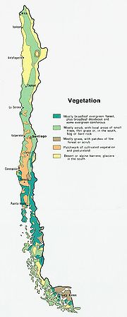
within its borders hosts at least seven major climatic subtypes, ranging from desert
Desert
A desert is a landscape or region that receives an extremely low amount of precipitation, less than enough to support growth of most plants. Most deserts have an average annual precipitation of less than...
in the north, to alpine tundra
Alpine tundra
Alpine tundra is a natural region that does not contain trees because it is at high altitude. Alpine tundra is distinguished from arctic tundra, because alpine soils are generally better drained than arctic soils...
and glacier
Glacier
A glacier is a large persistent body of ice that forms where the accumulation of snow exceeds its ablation over many years, often centuries. At least 0.1 km² in area and 50 m thick, but often much larger, a glacier slowly deforms and flows due to stresses induced by its weight...
s in the east and southeast, humid subtropical in Easter Island
Easter Island
Easter Island is a Polynesian island in the southeastern Pacific Ocean, at the southeasternmost point of the Polynesian triangle. A special territory of Chile that was annexed in 1888, Easter Island is famous for its 887 extant monumental statues, called moai, created by the early Rapanui people...
, Oceanic
Oceanic climate
An oceanic climate, also called marine west coast climate, maritime climate, Cascadian climate and British climate for Köppen climate classification Cfb and subtropical highland for Köppen Cfb or Cwb, is a type of climate typically found along the west coasts at the middle latitudes of some of the...
in the south and mediterranean climate
Mediterranean climate
A Mediterranean climate is the climate typical of most of the lands in the Mediterranean Basin, and is a particular variety of subtropical climate...
in central Chile. There are four seasons in most of the country: summer (December to February), autumn (March to May), winter (June to August), and spring (September to November).
On a synoptic scale the most important factors that controls the climate in Chile are the Pacific Anticyclone
Pacific High
The South Pacific High is a subtropical anticyclone located in the south east of the Pacific Ocean making the west coast of South America arid. Sechura and Atacama deserts, as the whole climate of Chile, are heavily influenced by this semi-permanent high pressure area....
, the southern circumpolar low pressure area
Low pressure area
A low-pressure area, or "low", is a region where the atmospheric pressure at sea level is below that of surrounding locations. Low-pressure systems form under areas of wind divergence which occur in upper levels of the troposphere. The formation process of a low-pressure area is known as...
, the cold Humboldt current
Humboldt Current
The Humboldt Current , also known as the Peru Current, is a cold, low-salinity ocean current that flows north-westward along the west coast of South America from the southern tip of Chile to northern Peru. It is an eastern boundary current flowing in the direction of the equator, and can extend...
, the Chilean Coast Range
Chilean Coast Range
The Chilean Coastal Range is a mountain range that runs from north to south along the Pacific coast of South America parallel to the Andean Mountains, extending from Morro de Arica in the north to Taitao Peninsula, where it ends at the Chile Triple Junction, in the south. The range has a strong...
and the Andes Mountains. Despite Chile's narrowness, some interior regions may experience wide temperature oscillations and cities such as San Pedro de Atacama
San Pedro de Atacama
San Pedro de Atacama is a Chilean town and commune in El Loa Province, Antofagasta Region. It is located east of Antofagasta, some 106 km southeast of Calama and the Chuquicamata copper mine, overlooking the Licancabur volcano. It features a significant archeological museum, the R. P...
, may even experience a continental climate
Continental climate
Continental climate is a climate characterized by important annual variation in temperature due to the lack of significant bodies of water nearby...
. In the extreme northeast and southeast the border of Chile extends beyond the Andes into the Altiplano
Altiplano
The Altiplano , in west-central South America, where the Andes are at their widest, is the most extensive area of high plateau on Earth outside of Tibet...
and the Patagonia
Patagonia
Patagonia is a region located in Argentina and Chile, integrating the southernmost section of the Andes mountains to the southwest towards the Pacific ocean and from the east of the cordillera to the valleys it follows south through Colorado River towards Carmen de Patagones in the Atlantic Ocean...
n plains, giving these regions climate patterns similar to those seen in Bolivia
Bolivia
Bolivia officially known as Plurinational State of Bolivia , is a landlocked country in central South America. It is the poorest country in South America...
and Argentina
Argentina
Argentina , officially the Argentine Republic , is the second largest country in South America by land area, after Brazil. It is constituted as a federation of 23 provinces and an autonomous city, Buenos Aires...
respectively.
Regions
| Climate Köppen climate classification The Köppen climate classification is one of the most widely used climate classification systems. It was first published by Crimea German climatologist Wladimir Köppen in 1884, with several later modifications by Köppen himself, notably in 1918 and 1936... | Ecoregion Ecoregion An ecoregion , sometimes called a bioregion, is an ecologically and geographically defined area that is smaller than an ecozone and larger than an ecosystem. Ecoregions cover relatively large areas of land or water, and contain characteristic, geographically distinct assemblages of natural... | Natural region Natural regions of Chile Because Chile extends from a point about 625 kilometers north of the Tropic of Capricorn to a point hardly more than 1,400 kilometers north of the Antarctic Circle, within its territory can be found a broad selection of the Earth's climates... |
|---|---|---|
| Desert Desert climate A desert climate , also known as an arid climate, is a climate that does not meet the criteria to be classified as a polar climate, and in which precipitation is too low to sustain any vegetation at all, or at most a very scanty scrub.An area that features this climate usually experiences less than... (BWh, BWk) |
Atacama desert Atacama Desert The Atacama Desert is a plateau in South America, covering a strip of land on the Pacific coast, west of the Andes mountains. It is, according to NASA, National Geographic and many other publications, the driest desert in the world... |
Norte Grande Norte Grande, Chile The Norte Grande is one of the five natural regions into which CORFO divided continental Chile in 1950. It borders Peru to the north, the Pacific Ocean to the west, the Altiplano, Bolivia and Argentina to the east, and the Copiapó River to the south, beyond which lies the Norte Chico natural... |
| Semi-arid (BWk, BSk, Csa) | Atacama desert Atacama Desert The Atacama Desert is a plateau in South America, covering a strip of land on the Pacific coast, west of the Andes mountains. It is, according to NASA, National Geographic and many other publications, the driest desert in the world... , Chilean matorral Chilean Matorral The Chilean Matorral is a terrestrial ecoregion of central Chile, located on the west coast of South America. It is in the Mediterranean forests, woodlands, and scrub biome, part of the Neotropic ecozone.... |
Norte Chico Norte Chico, Chile The Norte Chico is one of the five natural regions on which CORFO divided continental Chile in 1950. Its northern border is formed by the limit with the Far North, on west lies the Pacific Ocean, by the east the Andes mountains and Argentina, and by the south the Zona Central natural region... |
| Mediterranean Mediterranean climate A Mediterranean climate is the climate typical of most of the lands in the Mediterranean Basin, and is a particular variety of subtropical climate... (Csa, Csb) |
Chilean matorral Chilean Matorral The Chilean Matorral is a terrestrial ecoregion of central Chile, located on the west coast of South America. It is in the Mediterranean forests, woodlands, and scrub biome, part of the Neotropic ecozone.... |
Central Chile |
| Humid subtropical Humid subtropical climate A humid subtropical climate is a climate zone characterized by hot, humid summers and mild to cool winters... (Cfa) |
Easter Island Easter Island Easter Island is a Polynesian island in the southeastern Pacific Ocean, at the southeasternmost point of the Polynesian triangle. A special territory of Chile that was annexed in 1888, Easter Island is famous for its 887 extant monumental statues, called moai, created by the early Rapanui people... , Fernandezian Region Fernandezian Region The Fernandezian Region is a Floristic Region which includes two island groups, the Juan Fernández Islands and Desventuradas Islands archipelagoes, that lie in the South Pacific Ocean off the west coast of Chile... |
- |
| Temperate oceanic Oceanic climate An oceanic climate, also called marine west coast climate, maritime climate, Cascadian climate and British climate for Köppen climate classification Cfb and subtropical highland for Köppen Cfb or Cwb, is a type of climate typically found along the west coasts at the middle latitudes of some of the... (Cfb) |
Valdivian temperate rainforests | Zona Sur Zona Sur The Zona Sur is one of the five natural regions on which CORFO divided continental Chile in 1950. Its northern border is formed by the Bío-Bío River, the limit with the Central Chile Zone. By west with the Pacific Ocean, by the east with the Andean mountains and Argentina. Its southern border is... , Zona Austral Zona Austral The Zona Austral is one of the five natural regions into which CORFO divided continental Chile in 1950 corresponding to the Chilean portion of Patagonia. It is surrounded by the Southern Zone and the Chacao Channel to the north, the Pacific Ocean and Drake's Passage to the south and west, and the... |
| Subpolar oceanic Oceanic climate An oceanic climate, also called marine west coast climate, maritime climate, Cascadian climate and British climate for Köppen climate classification Cfb and subtropical highland for Köppen Cfb or Cwb, is a type of climate typically found along the west coasts at the middle latitudes of some of the... (Cfc) |
Magellanic subpolar forests Magellanic subpolar forests The Magellanic subpolar forests are a terrestrial ecoregion of southernmost South America, covering parts of southern Chile and Argentina, and is part of the Neotropic ecozone... |
Zona Austral Zona Austral The Zona Austral is one of the five natural regions into which CORFO divided continental Chile in 1950 corresponding to the Chilean portion of Patagonia. It is surrounded by the Southern Zone and the Chacao Channel to the north, the Pacific Ocean and Drake's Passage to the south and west, and the... |
| Semi-arid (BSk) | Patagonian Desert Patagonian Desert The Patagonian Desert, also known as the Patagonia Desert or the Patagonian Steppe, is the largest desert in Argentina and is the 7th largest desert in the world by area, occupying 673,000 square kilometers... |
Zona Austral Zona Austral The Zona Austral is one of the five natural regions into which CORFO divided continental Chile in 1950 corresponding to the Chilean portion of Patagonia. It is surrounded by the Southern Zone and the Chacao Channel to the north, the Pacific Ocean and Drake's Passage to the south and west, and the... |
| Alpine Alpine climate Alpine climate is the average weather for a region above the tree line. This climate is also referred to as mountain climate or highland climate.... |
Andes Andes The Andes is the world's longest continental mountain range. It is a continual range of highlands along the western coast of South America. This range is about long, about to wide , and of an average height of about .Along its length, the Andes is split into several ranges, which are separated... , Central Andean dry puna Central Andean dry puna The Central Andean dry puna is an ecoregion, in the Montane grasslands and shrublands biome, located in the Andean High plateau, in South America... |
all natural regions of Chile Natural regions of Chile Because Chile extends from a point about 625 kilometers north of the Tropic of Capricorn to a point hardly more than 1,400 kilometers north of the Antarctic Circle, within its territory can be found a broad selection of the Earth's climates... |
| Tundra (ET) | Andes Andes The Andes is the world's longest continental mountain range. It is a continual range of highlands along the western coast of South America. This range is about long, about to wide , and of an average height of about .Along its length, the Andes is split into several ranges, which are separated... , Central Andean dry puna Central Andean dry puna The Central Andean dry puna is an ecoregion, in the Montane grasslands and shrublands biome, located in the Andean High plateau, in South America... |
all natural regions of Chile Natural regions of Chile Because Chile extends from a point about 625 kilometers north of the Tropic of Capricorn to a point hardly more than 1,400 kilometers north of the Antarctic Circle, within its territory can be found a broad selection of the Earth's climates... |
| Ice cap Ice cap climate An ice cap climate is a polar climate where the temperature never or almost never exceeds . The climate covers the areas around the poles, such as Antarctica and Greenland, as well as the highest mountaintops. Such areas are covered by a permanent layer of ice and have no vegetation, but they do... (EF) |
Northern Patagonian Ice Field Northern Patagonian Ice Field The Northern Patagonian Ice Field, located in southern Chile, is the smaller of two remnant parts in which the Patagonian Ice Sheet in the Andes Mountains of lower South America can be divided. It is completely contained within the boundaries of Laguna San Rafael National Park... , Southern Patagonian Ice Field Southern Patagonian Ice Field The Southern Patagonian Ice Field , located at the Southern Patagonic Andes between Argentina and Chile, is the second largest contiguous extrapolar extent of ice in the world... |
Zona Austral Zona Austral The Zona Austral is one of the five natural regions into which CORFO divided continental Chile in 1950 corresponding to the Chilean portion of Patagonia. It is surrounded by the Southern Zone and the Chacao Channel to the north, the Pacific Ocean and Drake's Passage to the south and west, and the... |
Andes
There is no proper Andean climate, but instead a huge variety of different micro climates. The relief of the Andes allows a variety of different climatic zones to develop within relatively short distances. The different climates in the Andes often combine aspects of adjacent climate zones forming transition zones. In glaciology, Andes mountains can be divided in two climatic subregions; the Dry AndesDry Andes
The Dry Andes is a climatic and glaciological subregion of the Andes. Together with the Wet Andes it is one of the two subregions of the Argentine and Chilean Andes. The Dry Andes runs from the Atacama Desert in northern Chile and Argentina south to a latitude of 35°S in Chile. In Argentina the Dry...
and the Wet Andes
Wet Andes
The Wet Andes is a climatic and glaciological subregion of the Andes. Together with the Dry Andes it is one of the two subregions of the Argentine and Chilean Andes. The Wet Andes runs from a latitude of 35°S to Cape Horn at 56°S. According to Luis Lliboutry the Wet Andes can be classified after...
.
Subtropical
Easter Island
Easter Island is a Polynesian island in the southeastern Pacific Ocean, at the southeasternmost point of the Polynesian triangle. A special territory of Chile that was annexed in 1888, Easter Island is famous for its 887 extant monumental statues, called moai, created by the early Rapanui people...
is subtropical maritime
Humid subtropical climate
A humid subtropical climate is a climate zone characterized by hot, humid summers and mild to cool winters...
. The lowest temperatures are registered in July and August (18°C - 64°F) and the highest in February (maximum temperature 28°C ), the summer season in the southern hemisphere. Winters are relatively mild. The rainiest month is April, though the island experiences year-round rainfall. As an isolated island Easter Island is constantly exposed to winds which help to keep the temperature fairly cool. Precipitation averages 1,118 mm per year. Occasionally, heavy rainfall and rainstorms strike the island. These occur mostly in the winter months (June–August). Since it is close to the Pacific High
Pacific High
The South Pacific High is a subtropical anticyclone located in the south east of the Pacific Ocean making the west coast of South America arid. Sechura and Atacama deserts, as the whole climate of Chile, are heavily influenced by this semi-permanent high pressure area....
and outside the range of the ITCZ, cyclones and hurricanes do not occur around Easter island.
Dry arid
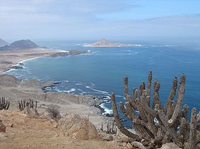
The Atacama Desert is the driest place on Earth
Earth
Earth is the third planet from the Sun, and the densest and fifth-largest of the eight planets in the Solar System. It is also the largest of the Solar System's four terrestrial planets...
, and is virtually sterile because it is blocked from moisture on both sides by the Andes
Andes
The Andes is the world's longest continental mountain range. It is a continual range of highlands along the western coast of South America. This range is about long, about to wide , and of an average height of about .Along its length, the Andes is split into several ranges, which are separated...
mountains and by the Chilean Coast Range
Chilean Coast Range
The Chilean Coastal Range is a mountain range that runs from north to south along the Pacific coast of South America parallel to the Andean Mountains, extending from Morro de Arica in the north to Taitao Peninsula, where it ends at the Chile Triple Junction, in the south. The range has a strong...
. The cold Humboldt Current
Humboldt Current
The Humboldt Current , also known as the Peru Current, is a cold, low-salinity ocean current that flows north-westward along the west coast of South America from the southern tip of Chile to northern Peru. It is an eastern boundary current flowing in the direction of the equator, and can extend...
and the Pacific Anticyclone are essential to keep the dry climate of Atacama Desert. The average rainfall in the Chilean region of Antofagasta
Antofagasta Region
The II Antofagasta Region is one of Chile's fifteen first-order administrative divisions. It comprises three provinces, Antofagasta, El Loa and Tocopilla...
is just 1 mm per year. Some weather stations in the Atacama have never received rain. Evidence suggests that the Atacama may not have had any significant rainfall from 1570 to 1971. It is so arid that mountains that reach as high as 6,885 metres (22,590 feet) are completely free of glacier
Glacier
A glacier is a large persistent body of ice that forms where the accumulation of snow exceeds its ablation over many years, often centuries. At least 0.1 km² in area and 50 m thick, but often much larger, a glacier slowly deforms and flows due to stresses induced by its weight...
s and, in the southern part from 25°S to 27°S, may have been glacier-free throughout the Quaternary
Quaternary
The Quaternary Period is the most recent of the three periods of the Cenozoic Era in the geologic time scale of the ICS. It follows the Neogene Period, spanning 2.588 ± 0.005 million years ago to the present...
— though permafrost
Permafrost
In geology, permafrost, cryotic soil or permafrost soil is soil at or below the freezing point of water for two or more years. Ice is not always present, as may be in the case of nonporous bedrock, but it frequently occurs and it may be in amounts exceeding the potential hydraulic saturation of...
extends down to an altitude of 4,400 metres and is continuous above 5,600 metres. Studies by a group of British scientists have suggested that some river beds have been dry for 120,000 years.
Some locations in the Atacama do receive a marine fog
Fog
Fog is a collection of water droplets or ice crystals suspended in the air at or near the Earth's surface. While fog is a type of stratus cloud, the term "fog" is typically distinguished from the more generic term "cloud" in that fog is low-lying, and the moisture in the fog is often generated...
known locally as the Camanchaca, providing sufficient moisture for hypolithic algae
Algae
Algae are a large and diverse group of simple, typically autotrophic organisms, ranging from unicellular to multicellular forms, such as the giant kelps that grow to 65 meters in length. They are photosynthetic like plants, and "simple" because their tissues are not organized into the many...
, lichen
Lichen
Lichens are composite organisms consisting of a symbiotic organism composed of a fungus with a photosynthetic partner , usually either a green alga or cyanobacterium...
s and even some cacti
Cactus
A cactus is a member of the plant family Cactaceae. Their distinctive appearance is a result of adaptations to conserve water in dry and/or hot environments. In most species, the stem has evolved to become photosynthetic and succulent, while the leaves have evolved into spines...
. But in the region that is in the "fog shadow" of the high coastal crest-line, which averages 3,000 m height for about 100 km south of Antofagasta, the soil has been compared to that of Mars
Mars
Mars is the fourth planet from the Sun in the Solar System. The planet is named after the Roman god of war, Mars. It is often described as the "Red Planet", as the iron oxide prevalent on its surface gives it a reddish appearance...
.
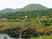
Mediterranean
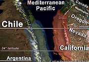
Santiago, Chile
Santiago , also known as Santiago de Chile, is the capital and largest city of Chile, and the center of its largest conurbation . It is located in the country's central valley, at an elevation of above mean sea level...
area, the average monthly temperatures are about 19.5 °C in the summer months of January and February and 7.5 °C in the winter months of June and July. The average monthly precipitation is no more than a trace in January and February and 69.7 millimeters in June and July. By contrast, in Concepción
Concepción, Chile
Concepción is a city in Chile, capital of Concepción Province and of the Biobío Region or Region VIII. Greater Concepción is the second-largest conurbation in the country, with 889,725 inhabitants...
the average monthly temperatures are somewhat lower in the summer at 17.6 °C but higher in the winter at 9.3 °C, and the amount of rain is much greater. In the summer, Concepción
Concepción, Chile
Concepción is a city in Chile, capital of Concepción Province and of the Biobío Region or Region VIII. Greater Concepción is the second-largest conurbation in the country, with 889,725 inhabitants...
receives an average of twenty millimeters of rain per month; in June and July, the city is pounded by an average of 253 millimeters per month. The numerous rivers greatly increase their flow as a result of the winter rains and the spring melting of the Andean snows, and they contract considerably in the summer. The combination of abundant snow in the Andes and relatively moderate winter temperatures creates excellent conditions for Alpine skiing. Areas around the Bío-Bío River
Bío-Bío River
The Biobío River is the second largest river in Chile. It originates from Icalma and Galletué lakes in the Andes and flows 380 km to the Gulf of Arauco on the Pacific Ocean....
, historically called La Frontera corresponds to southern limit of the mediterranean climate, with typical mediterranean fruits such as avocado, citrus, olives and grapes being cultivated north of it and oat, wheat, apples and potatoes to the south. This more or less drastic transition is caused by the split of the westerlies
Westerlies
The Westerlies, anti-trades, or Prevailing Westerlies, are the prevailing winds in the middle latitudes between 30 and 60 degrees latitude, blowing from the high pressure area in the horse latitudes towards the poles. These prevailing winds blow from the west to the east, and steer extratropical...
at these latitudes (~37° S) into one branch going to the southeast and another to the northeast, to this it is necessary to add the north-south lowering of the Chilean Coast Range
Chilean Coast Range
The Chilean Coastal Range is a mountain range that runs from north to south along the Pacific coast of South America parallel to the Andean Mountains, extending from Morro de Arica in the north to Taitao Peninsula, where it ends at the Chile Triple Junction, in the south. The range has a strong...
which reduced the rain shadow
Rain shadow
A rain shadow is a dry area on the lee side of a mountainous area. The mountains block the passage of rain-producing weather systems, casting a "shadow" of dryness behind them. As shown by the diagram to the right, the warm moist air is "pulled" by the prevailing winds over a mountain...
effect.
Temperate oceanic
In Zona Sur
Zona Sur
The Zona Sur is one of the five natural regions on which CORFO divided continental Chile in 1950. Its northern border is formed by the Bío-Bío River, the limit with the Central Chile Zone. By west with the Pacific Ocean, by the east with the Andean mountains and Argentina. Its southern border is...
and the northern part of Zona Austral
Zona Austral
The Zona Austral is one of the five natural regions into which CORFO divided continental Chile in 1950 corresponding to the Chilean portion of Patagonia. It is surrounded by the Southern Zone and the Chacao Channel to the north, the Pacific Ocean and Drake's Passage to the south and west, and the...
the climate is Temperate oceanic
Oceanic climate
An oceanic climate, also called marine west coast climate, maritime climate, Cascadian climate and British climate for Köppen climate classification Cfb and subtropical highland for Köppen Cfb or Cwb, is a type of climate typically found along the west coasts at the middle latitudes of some of the...
. Here the Andean Cordillera intercepts moist westerly winds along the Pacific coast during winter and summer months; these winds cool as they ascend the mountains, creating heavy rainfall on the mountains' west-facing slopes. The northward-flowing oceanic Humboldt Current creates humid and foggy conditions near the coast. The tree line is at about 2,400 m in the northern part of the ecoregion (35° S), and descends to 1,000 m in the south of the Valdivian region. In the summer
Summer
Summer is the warmest of the four temperate seasons, between spring and autumn. At the summer solstice, the days are longest and the nights are shortest, with day-length decreasing as the season progresses after the solstice...
average temperature can climb to 16.5°C (62°F), while during winter the temperature can drop below 7°C (45°F).
Subpolar oceanic
The seasonal temperature in Zona AustralZona Austral
The Zona Austral is one of the five natural regions into which CORFO divided continental Chile in 1950 corresponding to the Chilean portion of Patagonia. It is surrounded by the Southern Zone and the Chacao Channel to the north, the Pacific Ocean and Drake's Passage to the south and west, and the...
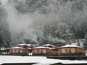
is greatly moderated by its proximity to the ocean and is known for stable constant temperatures, only small variability with season. The heaviest rainfalls goes between April and May and snow season goes all through Chilean winter (June till September), although the average temperature does not descend below 1°C in coastal areas.
Climate charts for different locations of Chile
See also
- Agriculture in ChileAgriculture in ChileAgriculture in Chile encompasses a wide range of different activities due its particular geography, climate and geology and human factors. Historically agriculture is one of the bases of Chile's economy, now agriculture and allied sectors like forestry, logging and fishing accounts only for 4.9% of...
- Geography of ChileGeography of ChileImage:Chilenav.gif|thumb|417px|left|Click over the map to obtain a topographic map of the region and its toponymyrect 23 14 119 35 rect 23 35 119 44 rect 23 44 119 54 rect 23 54 119 65 rect 23 65 119 75 rect 23 75 119 85...
- Geology of ChileGeology of ChileThe Geology of Chile is mainly a product of the Andean and preceding orogenies which are caused by the long-lived convergent boundary at South America's western coast. While in the Paleozoic and Precambrian this boundary was affected by the accretion of terranes and microcontinents it has since...
- Glaciers of ChileGlaciers of ChileThe glaciers of Chile cover 2.7% of the land area of the country, excluding Antártica Chilena, and have a considerable impact on its landscape and water supply. By surface 80% of South America's glaciers lie in Chile...
- Natural regions of ChileNatural regions of ChileBecause Chile extends from a point about 625 kilometers north of the Tropic of Capricorn to a point hardly more than 1,400 kilometers north of the Antarctic Circle, within its territory can be found a broad selection of the Earth's climates...
- White EarthquakeWhite Earthquakethumb|400px|Map of Chile showing communes in state of catastrophe during the White Earthquake in red. Communes in pink were declared zones of "agrarian emergency"...