

Geology of Chile
Encyclopedia
Andes
The Andes is the world's longest continental mountain range. It is a continual range of highlands along the western coast of South America. This range is about long, about to wide , and of an average height of about .Along its length, the Andes is split into several ranges, which are separated...
and preceding orogenies
Orogeny
Orogeny refers to forces and events leading to a severe structural deformation of the Earth's crust due to the engagement of tectonic plates. Response to such engagement results in the formation of long tracts of highly deformed rock called orogens or orogenic belts...
which are caused by the long-lived convergent boundary
Convergent boundary
In plate tectonics, a convergent boundary, also known as a destructive plate boundary , is an actively deforming region where two tectonic plates or fragments of lithosphere move toward one another and collide...
at South America's western coast. While in the Paleozoic
Paleozoic
The Paleozoic era is the earliest of three geologic eras of the Phanerozoic eon, spanning from roughly...
and Precambrian
Precambrian
The Precambrian is the name which describes the large span of time in Earth's history before the current Phanerozoic Eon, and is a Supereon divided into several eons of the geologic time scale...
this boundary was affected by the accretion of terrane
Terrane
A terrane in geology is short-hand term for a tectonostratigraphic terrane, which is a fragment of crustal material formed on, or broken off from, one tectonic plate and accreted or "sutured" to crust lying on another plate...
s and microcontinents it has since then developed into a pure subduction
Subduction
In geology, subduction is the process that takes place at convergent boundaries by which one tectonic plate moves under another tectonic plate, sinking into the Earth's mantle, as the plates converge. These 3D regions of mantle downwellings are known as "Subduction Zones"...
zone. The subduction have shaped four features parallel to its strike
Strike and dip
Strike and dip refer to the orientation or attitude of a geologic feature. The strike line of a bed, fault, or other planar feature is a line representing the intersection of that feature with a horizontal plane. On a geologic map, this is represented with a short straight line segment oriented...
; the Andes
Andes
The Andes is the world's longest continental mountain range. It is a continual range of highlands along the western coast of South America. This range is about long, about to wide , and of an average height of about .Along its length, the Andes is split into several ranges, which are separated...
, the Intermediate Depression
Chilean Central Valley
The Central Valley , Intermediate Depression or Longitudinal Valley is the depression between the Chilean Costal Range and the Andes Mountains. The central valley should not be confused with Central Chile that encompasses part of the valley...
which is a graben
Graben
In geology, a graben is a depressed block of land bordered by parallel faults. Graben is German for ditch. Graben is used for both the singular and plural....
and foreland basin
Foreland basin
A foreland basin is a depression that develops adjacent and parallel to a mountain belt. Foreland basins form because the immense mass created by crustal thickening associated with the evolution of a mountain belt causes the lithosphere to bend, by a process known as lithospheric flexure...
, the Coast Range
Chilean Coast Range
The Chilean Coastal Range is a mountain range that runs from north to south along the Pacific coast of South America parallel to the Andean Mountains, extending from Morro de Arica in the north to Taitao Peninsula, where it ends at the Chile Triple Junction, in the south. The range has a strong...
which is an accretionary wedge
Accretionary wedge
An accretionary wedge or accretionary prism is formed from sediments that are accreted onto the non-subducting tectonic plate at a convergent plate boundary...
and horst and the Peru-Chile Trench
Peru-Chile Trench
The Peru-Chile Trench, also known as the Atacama Trench, is an oceanic trench in the eastern Pacific Ocean, about 160 kilometres off the coast of Peru and Chile...
off the coast. As Chile lies in an active continental margin
Continental margin
The continental margin is the zone of the ocean floor that separates the thin oceanic crust from thick continental crust. Continental margins constitute about 28% of the oceanic area....
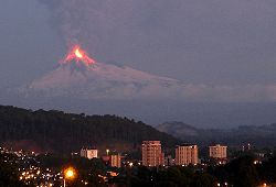
, it host a large number of subduction volcano
Volcano
2. Bedrock3. Conduit 4. Base5. Sill6. Dike7. Layers of ash emitted by the volcano8. Flank| 9. Layers of lava emitted by the volcano10. Throat11. Parasitic cone12. Lava flow13. Vent14. Crater15...
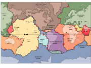
es and nearly all of the territory of Chile is subject to earthquakes arising from strains in the subducting Nazca
Nazca Plate
]The Nazca Plate, named after the Nazca region of southern Peru, is an oceanic tectonic plate in the eastern Pacific Ocean basin off the west coast of South America. The ongoing subduction along the Peru-Chile Trench of the Nazca Plate under the South American Plate is largely responsible for the...
and Antarctic Plate
Antarctic Plate
The Antarctic Plate is a tectonic plate covering the continent of Antarctica and extending outward under the surrounding oceans. The Antarctic Plate has a boundary with the Nazca Plate, the South American Plate, the African Plate, the Indo-Australian Plate, the Scotia Plate and a divergent boundary...
s or shallow strike-slip faults.
Mineral resources in the northern regions of Chile have since late 19th century made up the bulk of the country's export and state income. Chile is currently a leading producer of copper
Copper
Copper is a chemical element with the symbol Cu and atomic number 29. It is a ductile metal with very high thermal and electrical conductivity. Pure copper is soft and malleable; an exposed surface has a reddish-orange tarnish...
, lithium
Lithium
Lithium is a soft, silver-white metal that belongs to the alkali metal group of chemical elements. It is represented by the symbol Li, and it has the atomic number 3. Under standard conditions it is the lightest metal and the least dense solid element. Like all alkali metals, lithium is highly...
and molybdenum
Molybdenum
Molybdenum , is a Group 6 chemical element with the symbol Mo and atomic number 42. The name is from Neo-Latin Molybdaenum, from Ancient Greek , meaning lead, itself proposed as a loanword from Anatolian Luvian and Lydian languages, since its ores were confused with lead ores...
. Much of the countries mineral wealth have accumlated thanks to long lived volcanic and magma
Magma
Magma is a mixture of molten rock, volatiles and solids that is found beneath the surface of the Earth, and is expected to exist on other terrestrial planets. Besides molten rock, magma may also contain suspended crystals and dissolved gas and sometimes also gas bubbles. Magma often collects in...
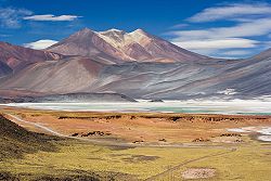
tic activity as well as the extreme aridity that have prevailed over Atacama Desert
Atacama Desert
The Atacama Desert is a plateau in South America, covering a strip of land on the Pacific coast, west of the Andes mountains. It is, according to NASA, National Geographic and many other publications, the driest desert in the world...
for millions of years.
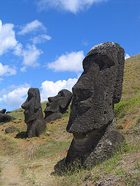
The Chilean territories of Easter Island
Easter Island
Easter Island is a Polynesian island in the southeastern Pacific Ocean, at the southeasternmost point of the Polynesian triangle. A special territory of Chile that was annexed in 1888, Easter Island is famous for its 887 extant monumental statues, called moai, created by the early Rapanui people...
, and Juan Fernández Archipelago are extinct volcanic hotspot
Hotspot (geology)
The places known as hotspots or hot spots in geology are volcanic regions thought to be fed by underlying mantle that is anomalously hot compared with the mantle elsewhere. They may be on, near to, or far from tectonic plate boundaries. There are two hypotheses to explain them...
islands in the eastward moving Nazca plate
Nazca Plate
]The Nazca Plate, named after the Nazca region of southern Peru, is an oceanic tectonic plate in the eastern Pacific Ocean basin off the west coast of South America. The ongoing subduction along the Peru-Chile Trench of the Nazca Plate under the South American Plate is largely responsible for the...
. The Antarctic Peninsula
Antarctic Peninsula
The Antarctic Peninsula is the northernmost part of the mainland of Antarctica. It extends from a line between Cape Adams and a point on the mainland south of Eklund Islands....
, claimed as part of the Chilean Antarctic Territory, shares a series of characteristics with the southern Andes.
General characteristics
The Andes derive in three mayor morphological features are present in most of the country; the proper Andes Mountains, the Chilean Coast RangeChilean Coast Range
The Chilean Coastal Range is a mountain range that runs from north to south along the Pacific coast of South America parallel to the Andean Mountains, extending from Morro de Arica in the north to Taitao Peninsula, where it ends at the Chile Triple Junction, in the south. The range has a strong...
and the Chilean Central Valley
Chilean Central Valley
The Central Valley , Intermediate Depression or Longitudinal Valley is the depression between the Chilean Costal Range and the Andes Mountains. The central valley should not be confused with Central Chile that encompasses part of the valley...
(also called Intermediate Depression and Longitudinal Valley) between them. These features run parallelly in a north-south direction from Morro de Arica
Morro de Arica
Morro de Arica is a steep hill located in the Chilean city of Arica. Its height is 139 metres above sea level. It was the last bulwark of defence for the Peruvian troops who garrisoned the city during the War of the Pacific...
to Taitao Peninsula
Taitao Peninsula
The Taitao Peninsula is a westward projection of the mainland of Chile, with which it is connected by the narrow Isthmus of Ofqui, over which the natives and early missionaries were accustomed to carry their boats between the Moraleda Channel and Gulf of Penas...
, covering up most of Chile's land surface. Further south from Taitao only the Andes Mountains is present.
North of Taitao Peninsula this subduction zone is made up of the Peru-Chile Trench
Peru-Chile Trench
The Peru-Chile Trench, also known as the Atacama Trench, is an oceanic trench in the eastern Pacific Ocean, about 160 kilometres off the coast of Peru and Chile...
which is the boundary between the South American and the Nazca Plates. At the site of Taitao the triple junction
Triple junction
A triple junction is the point where the boundaries of three tectonic plates meet. At the triple junction a boundary will be one of 3 types - a ridge, trench or transform fault - and triple junctions can be described according to the types of plate margin that meet at them...
of the Antarctic
Antarctic
The Antarctic is the region around the Earth's South Pole, opposite the Arctic region around the North Pole. The Antarctic comprises the continent of Antarctica and the ice shelves, waters and island territories in the Southern Ocean situated south of the Antarctic Convergence...
, the Nazca plate subducts under the continent.
The Andes
In general the Andes tend to lose height to the south of Chile. In Norte GrandeNorte Grande
Norte Grande is a civil parish in the municipality of Velas on the island of São Jorge in the Azores; owing to the existence of an ecumenical faith community throughout its history, the parish has also taken on the name of its religious invokation...
the mountains forms a series a plateaus such as Puna de Atacama
Puna de Atacama
The Puna de Atacama or Atacama Plateau is an arid high plateau averaging about above sea level and spanning an area of , in the Andes of northern Chile and Argentina and southwest Bolivia. Before the War of the Pacific , the region belonged to Bolivia. In 1898 it was ceded to Argentina in...
and the Altiplano
Altiplano
The Altiplano , in west-central South America, where the Andes are at their widest, is the most extensive area of high plateau on Earth outside of Tibet...
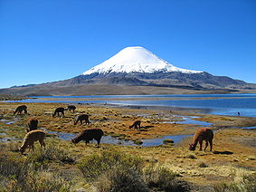
. At a latitude of 27° S, Chile's highest mountain Ojos del Salado
Ojos del Salado
Nevado Ojos del Salado is a massive stratovolcano in the Andes on the Argentina-Chile border and the highest volcano in the world at . It is also the second highest mountain in the Western Hemisphere and Southern Hemisphere and the highest in Chile...
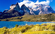
reaches 6,893 metres. South of latitude of 42° S the Andes are split into a fjord
Fjord
Geologically, a fjord is a long, narrow inlet with steep sides or cliffs, created in a valley carved by glacial activity.-Formation:A fjord is formed when a glacier cuts a U-shaped valley by abrasion of the surrounding bedrock. Glacial melting is accompanied by rebound of Earth's crust as the ice...
landscape and the highest mountain is Monte San Lorenzo
Monte San Lorenzo
Monte San Lorenzo, also known as Monte Cochrane, is a mountain on the border between Argentina and Chile in Patagonia, reaching a height of . The Chilean name of Cochrane comes from the nearby town of Cochrane where climbers often approach the mountain...
with 3,706 m. As the mountains lowers so does the snow line
Snow line
The climatic snow line is the point above which snow and ice cover the ground throughout the year. The actual snow line may seasonally be significantly lower....
, in the Llanquihue it is at 1,200 m and at Magallanes it is down at 900 m.
Intermediate Depression
The Intermediate Depression separates the Andes from the Coast Range. It is delimited a series of faults running in north-south direction. Just like the Andes and the Coast Range it tends to lose height with increasing latitude. In Norte GrandeNorte Grande
Norte Grande is a civil parish in the municipality of Velas on the island of São Jorge in the Azores; owing to the existence of an ecumenical faith community throughout its history, the parish has also taken on the name of its religious invokation...
the intermediate depression is partly covered by a series of salt flats and has the world's largest potassium nitrate
Potassium nitrate
Potassium nitrate is a chemical compound with the formula KNO3. It is an ionic salt of potassium ions K+ and nitrate ions NO3−.It occurs as a mineral niter and is a natural solid source of nitrogen. Its common names include saltpetre , from medieval Latin sal petræ: "stone salt" or possibly "Salt...
deposits. In Norte Chico
Norte Chico, Chile
The Norte Chico is one of the five natural regions on which CORFO divided continental Chile in 1950. Its northern border is formed by the limit with the Far North, on west lies the Pacific Ocean, by the east the Andes mountains and Argentina, and by the south the Zona Central natural region...
the depression is absent but it appears again as a narrow valley at Santiago
Santiago, Chile
Santiago , also known as Santiago de Chile, is the capital and largest city of Chile, and the center of its largest conurbation . It is located in the country's central valley, at an elevation of above mean sea level...
. At 34° S the depression goes through two narrows where the two ranges came close again. From the narrows southward the valley widens but is interrupted near Loncoche
Loncoche
Loncoche is a city and commune in the Araucanía Region, southern Chile. It is located near the border to Los Ríos Region and the city of Lanco.Loncoche is a major centre for milk production...
by the Bahía Mansa Metamorphic Complex
Bahía Mansa Metamorphic Complex
The Bahía Mansa Metamorphic Complex or BMMC is a group of metamorphic geologic formations of the Chilean Coast Range in southern Chile. It consists mainly in pelitic schists, metagreywackes and oceanic type mafic metavolcanics....
that is part of the Coast Range. The valley opens again as Los Llanos
Los Llanos, Chile
Los Llanos is a historical term for the flatland area encompassing the Chilean Central Valley between Valdivia and Osorno. It includes parts of the communes of Paillaco, La Unión, Río Bueno, Osorno and San Pablo....
near Paillaco
Paillaco
Paillaco is a city and commune in southern Chile. It is located in Valdivia Province in Los Ríos Region, and is about 48 km southeast of Valdivia...
. In central and southern Chile (33°-42° S) it is partly covered with glacifluvial sediments from the Andes. In Zona Austral
Zona Austral
The Zona Austral is one of the five natural regions into which CORFO divided continental Chile in 1950 corresponding to the Chilean portion of Patagonia. It is surrounded by the Southern Zone and the Chacao Channel to the north, the Pacific Ocean and Drake's Passage to the south and west, and the...
, south of 42° S, the depressions is beneath sea level
Sea level
Mean sea level is a measure of the average height of the ocean's surface ; used as a standard in reckoning land elevation...
but appears again occasionally in islands such as Chiloé
Chiloé Island
Chiloé Island , also known as Greater Island of Chiloé , is the largest island of the Chiloé Archipelago off the coast of Chile, in the Pacific Ocean...
. Its southern extreme is marked by the Isthmus of Ofqui
Isthmus of Ofqui
Isthmus of Ofqui is a narrow isthmus that connects the Taitao Peninsula with the Chilean mainland. The isthmus is bounded in the south by the Gulf of Penas, in the north by the San Rafael Lagoon, in the west by the Taitao Peninsula and in the east by the Northern Patagonia Ice Field.Geologically...
.
Chilean Coast Range
The Chilean Coast RangeChilean Coast Range
The Chilean Coastal Range is a mountain range that runs from north to south along the Pacific coast of South America parallel to the Andean Mountains, extending from Morro de Arica in the north to Taitao Peninsula, where it ends at the Chile Triple Junction, in the south. The range has a strong...
is a mountain range that runs southward along the coast parallel with the Andean Mountains
Andes
The Andes is the world's longest continental mountain range. It is a continual range of highlands along the western coast of South America. This range is about long, about to wide , and of an average height of about .Along its length, the Andes is split into several ranges, which are separated...
, from Morro de Arica
Morro de Arica
Morro de Arica is a steep hill located in the Chilean city of Arica. Its height is 139 metres above sea level. It was the last bulwark of defence for the Peruvian troops who garrisoned the city during the War of the Pacific...
to Taitao Peninsula
Taitao Peninsula
The Taitao Peninsula is a westward projection of the mainland of Chile, with which it is connected by the narrow Isthmus of Ofqui, over which the natives and early missionaries were accustomed to carry their boats between the Moraleda Channel and Gulf of Penas...
where it ends at the Chile Triple Junction
Chile Triple Junction
The Chile Triple Junction is a geologic triple junction located on the seafloor of the Pacific Ocean off Taitao and Tres Montes Peninsula on the southern coast of Chile. Here three tectonic plates meet: the South American Plate, the Nazca Plate, and the Antarctic Plate...
. The range is a combined horst, forearc high
Foreland basin
A foreland basin is a depression that develops adjacent and parallel to a mountain belt. Foreland basins form because the immense mass created by crustal thickening associated with the evolution of a mountain belt causes the lithosphere to bend, by a process known as lithospheric flexure...
and accretionary wedge
Accretionary wedge
An accretionary wedge or accretionary prism is formed from sediments that are accreted onto the non-subducting tectonic plate at a convergent plate boundary...
structure. The range was separated from the Andes during the Tertiary
Tertiary
The Tertiary is a deprecated term for a geologic period 65 million to 2.6 million years ago. The Tertiary covered the time span between the superseded Secondary period and the Quaternary...
rise of the Andes due to the subsidence
Subsidence
Subsidence is the motion of a surface as it shifts downward relative to a datum such as sea-level. The opposite of subsidence is uplift, which results in an increase in elevation...
of the Intermediate Depression.
Geologic history
Paleozoic Era
The oldest rocks in Chile are micaMica
The mica group of sheet silicate minerals includes several closely related materials having highly perfect basal cleavage. All are monoclinic, with a tendency towards pseudohexagonal crystals, and are similar in chemical composition...
ceous schist
Schist
The schists constitute a group of medium-grade metamorphic rocks, chiefly notable for the preponderance of lamellar minerals such as micas, chlorite, talc, hornblende, graphite, and others. Quartz often occurs in drawn-out grains to such an extent that a particular form called quartz schist is...
s, phyllite
Phyllite
Phyllite is a type of foliated metamorphic rock primarily composed of quartz, sericite mica, and chlorite; the rock represents a gradation in the degree of metamorphism between slate and mica schist. Minute crystals of graphite, sericite, or chlorite impart a silky, sometimes golden sheen to the...
s, gneiss
Gneiss
Gneiss is a common and widely distributed type of rock formed by high-grade regional metamorphic processes from pre-existing formations that were originally either igneous or sedimentary rocks.-Etymology:...
es and quartzite
Quartzite
Quartzite is a hard metamorphic rock which was originally sandstone. Sandstone is converted into quartzite through heating and pressure usually related to tectonic compression within orogenic belts. Pure quartzite is usually white to gray, though quartzites often occur in various shades of pink...
s which are mostly found in the Coast Range
Chilean Coast Range
The Chilean Coastal Range is a mountain range that runs from north to south along the Pacific coast of South America parallel to the Andean Mountains, extending from Morro de Arica in the north to Taitao Peninsula, where it ends at the Chile Triple Junction, in the south. The range has a strong...
of south-central Chile. The schist of southern Chile
Zona Sur
The Zona Sur is one of the five natural regions on which CORFO divided continental Chile in 1950. Its northern border is formed by the Bío-Bío River, the limit with the Central Chile Zone. By west with the Pacific Ocean, by the east with the Andean mountains and Argentina. Its southern border is...
were initially formed by sedimentation into the proto-Pacific Ocean and underwent later a stage of metamorphism in the forearc
Forearc
A forearc or forarc, also called arc-trench gap is a depression in the sea floor located between a subduction zone and an associated volcanic arc. It is typically filled with sediments from the adjacent landmass and the island arc in addition to trapped oceanic crustal material...
wedge of the Peru-Chile Trench
Peru-Chile Trench
The Peru-Chile Trench, also known as the Atacama Trench, is an oceanic trench in the eastern Pacific Ocean, about 160 kilometres off the coast of Peru and Chile...
.
Mesozoic Era
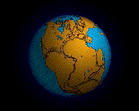
Some 250 million years ago during the TriassicTriassic
The Triassic is a geologic period and system that extends from about 250 to 200 Mya . As the first period of the Mesozoic Era, the Triassic follows the Permian and is followed by the Jurassic. Both the start and end of the Triassic are marked by major extinction events...
period, Chile was part of the supercontinent
Supercontinent
In geology, a supercontinent is a landmass comprising more than one continental core, or craton. The assembly of cratons and accreted terranes that form Eurasia qualifies as a supercontinent today.-History:...
Pangea which concentrated all major land masses in the world. In Pangea Africa
Africa
Africa is the world's second largest and second most populous continent, after Asia. At about 30.2 million km² including adjacent islands, it covers 6% of the Earth's total surface area and 20.4% of the total land area...
, Antarctica, Australia
Australia
Australia , officially the Commonwealth of Australia, is a country in the Southern Hemisphere comprising the mainland of the Australian continent, the island of Tasmania, and numerous smaller islands in the Indian and Pacific Oceans. It is the world's sixth-largest country by total area...
and India
India
India , officially the Republic of India , is a country in South Asia. It is the seventh-largest country by geographical area, the second-most populous country with over 1.2 billion people, and the most populous democracy in the world...
were closest to Chile. When Pangea began to split apart in the Jurassic
Jurassic
The Jurassic is a geologic period and system that extends from about Mya to Mya, that is, from the end of the Triassic to the beginning of the Cretaceous. The Jurassic constitutes the middle period of the Mesozoic era, also known as the age of reptiles. The start of the period is marked by...
, South America and the adjacent land masses formed Gondwana
Gondwana
In paleogeography, Gondwana , originally Gondwanaland, was the southernmost of two supercontinents that later became parts of the Pangaea supercontinent. It existed from approximately 510 to 180 million years ago . Gondwana is believed to have sutured between ca. 570 and 510 Mya,...
. Floral affinities among these now-distant landmasses date from the Gondwanaland period (see also: Antarctic Floristic Kingdom
Antarctic Floristic Kingdom
The Antarctic Floristic Kingdom is a floristic region first identified by botanist Ronald Good , which includes most areas of the world south of 40°S latitude...
). Then India split apart followed by the creation of the Mid-Atlantic Ridge
Mid-Atlantic Ridge
The Mid-Atlantic Ridge is a mid-ocean ridge, a divergent tectonic plate boundary located along the floor of the Atlantic Ocean, and part of the longest mountain range in the world. It separates the Eurasian Plate and North American Plate in the North Atlantic, and the African Plate from the South...
that separates Africa from South America.
The formation of the Andes began in the Jurassic Period. It was during the Cretaceous
Cretaceous
The Cretaceous , derived from the Latin "creta" , usually abbreviated K for its German translation Kreide , is a geologic period and system from circa to million years ago. In the geologic timescale, the Cretaceous follows the Jurassic period and is followed by the Paleogene period of the...
Period that the Andes began to take their present form, by the uplifting, faulting and folding
Fold (geology)
The term fold is used in geology when one or a stack of originally flat and planar surfaces, such as sedimentary strata, are bent or curved as a result of permanent deformation. Synsedimentary folds are those due to slumping of sedimentary material before it is lithified. Folds in rocks vary in...
of sedimentary and metamorphic rocks of the ancient craton
Craton
A craton is an old and stable part of the continental lithosphere. Having often survived cycles of merging and rifting of continents, cratons are generally found in the interiors of tectonic plates. They are characteristically composed of ancient crystalline basement rock, which may be covered by...
s to the east. 27 million years ago South America separated from Antarctica and Australia with the genesis of the Drake Passage
Drake Passage
The Drake Passage or Mar de Hoces—Sea of Hoces—is the body of water between the southern tip of South America at Cape Horn, Chile and the South Shetland Islands of Antarctica...
. Tectonic forces along the subduction zone along the entire west coast of South America where the Nazca Plate
Nazca Plate
]The Nazca Plate, named after the Nazca region of southern Peru, is an oceanic tectonic plate in the eastern Pacific Ocean basin off the west coast of South America. The ongoing subduction along the Peru-Chile Trench of the Nazca Plate under the South American Plate is largely responsible for the...
and a part of the Antarctic Plate
Antarctic Plate
The Antarctic Plate is a tectonic plate covering the continent of Antarctica and extending outward under the surrounding oceans. The Antarctic Plate has a boundary with the Nazca Plate, the South American Plate, the African Plate, the Indo-Australian Plate, the Scotia Plate and a divergent boundary...
are sliding beneath the South American Plate
South American Plate
The South American Plate is a continental tectonic plate which includes the continent of South America and also a sizeable region of the Atlantic Ocean seabed extending eastward to the Mid-Atlantic Ridge....
continue to produce an ongoing orogenic event
Orogeny
Orogeny refers to forces and events leading to a severe structural deformation of the Earth's crust due to the engagement of tectonic plates. Response to such engagement results in the formation of long tracts of highly deformed rock called orogens or orogenic belts...
resulting in minor to major earthquakes and volcanic eruptions to this day. In the extreme south Magallanes-Fagnano Fault
Magallanes-Fagnano Fault
The Magallanes-Fagnano fault is a continental transform fault.The fault marks a transform boundary between the Scotia Plate and the South American Plate, cutting across continental crust. It runs under the Strait of Magellan's western arm, Almirantazgo Sound and Fagnano Lake....
separates Tierra del Fuego
Tierra del Fuego
Tierra del Fuego is an archipelago off the southernmost tip of the South American mainland, across the Strait of Magellan. The archipelago consists of a main island Isla Grande de Tierra del Fuego divided between Chile and Argentina with an area of , and a group of smaller islands including Cape...
from the small Scotia Plate
Scotia Plate
The Scotia Plate is an oceanic tectonic plate bordering the South American Plate on the north, the South Sandwich Plate to the east, and the Antarctic Plate on the south and west....
. Across the 1000 km (621.4 mi) wide Drake Passage lie the mountains of the Antarctic Peninsula
Antarctic Peninsula
The Antarctic Peninsula is the northernmost part of the mainland of Antarctica. It extends from a line between Cape Adams and a point on the mainland south of Eklund Islands....
south of the Scotia Plate which appear to be a continuation of the Andes chain.
Cenozoic Era
The AltiplanoAltiplano
The Altiplano , in west-central South America, where the Andes are at their widest, is the most extensive area of high plateau on Earth outside of Tibet...
plateau
Plateau
In geology and earth science, a plateau , also called a high plain or tableland, is an area of highland, usually consisting of relatively flat terrain. A highly eroded plateau is called a dissected plateau...
was formed during the Tertiary
Tertiary
The Tertiary is a deprecated term for a geologic period 65 million to 2.6 million years ago. The Tertiary covered the time span between the superseded Secondary period and the Quaternary...
and several mechanisms have been suggested as responsible for its formation, aiming to explain why the topography in the Andes incorporates this large area of low relief at high altitude (high plateau) within the orogen:
- Existence of weaknesses in the Earth's crust prior to tectonic shortening. Such weaknesses would cause the partition of tectonic deformation and uplift into eastern and western cordillera, leaving the necessary space for the formation of the altiplano basin.
- Magmatic processes rooted in the asthenosphere might have contributed to uplift the plateau.
- Climate has controlled the spatial distribution of erosion and sediment deposition, controlling the lubrication along the Nazca Plate subduction and hence influencing the transmission of tectonic forces into South America.
- Climate also determined the formation of internal drainage (endorheism) and sediment trapping within the Andes, potentially blocking tectonic deformation in the area between the two cordilleras.
Quaternary
The QuaternaryQuaternary
The Quaternary Period is the most recent of the three periods of the Cenozoic Era in the geologic time scale of the ICS. It follows the Neogene Period, spanning 2.588 ± 0.005 million years ago to the present...
glaciations have left visible marks in most of Chile but particularly in Zona Sur
Zona Sur
The Zona Sur is one of the five natural regions on which CORFO divided continental Chile in 1950. Its northern border is formed by the Bío-Bío River, the limit with the Central Chile Zone. By west with the Pacific Ocean, by the east with the Andean mountains and Argentina. Its southern border is...
and Zona Austral
Zona Austral
The Zona Austral is one of the five natural regions into which CORFO divided continental Chile in 1950 corresponding to the Chilean portion of Patagonia. It is surrounded by the Southern Zone and the Chacao Channel to the north, the Pacific Ocean and Drake's Passage to the south and west, and the...
. These include ice field
Ice field
An ice field is an area less than 50,000 km² of ice often found in the colder climates and higher altitudes of the world where there is sufficient precipitation. It is an extensive area of interconnected valley glaciers from which the higher peaks rise as nunataks...
s, fjord
Fjord
Geologically, a fjord is a long, narrow inlet with steep sides or cliffs, created in a valley carved by glacial activity.-Formation:A fjord is formed when a glacier cuts a U-shaped valley by abrasion of the surrounding bedrock. Glacial melting is accompanied by rebound of Earth's crust as the ice...
s, glacial lake
Glacial lake
A glacial lake is a lake with origins in a melted glacier. Near the end of the last glacial period, roughly 10,000 years ago, glaciers began to retreat. A retreating glacier often left behind large deposits of ice in hollows between drumlins or hills. As the ice age ended, these melted to create...
s and u-shaped valleys. During the Santa María glaciation glaciers penetrated into the Pacific Ocean at 42° S dividing the Chilean Coast Range
Chilean Coast Range
The Chilean Coastal Range is a mountain range that runs from north to south along the Pacific coast of South America parallel to the Andean Mountains, extending from Morro de Arica in the north to Taitao Peninsula, where it ends at the Chile Triple Junction, in the south. The range has a strong...
and created what is now Chacao Channel
Chacao Channel
The Chacao Channel is located in Los Lagos Region, Chile and separates Chiloé Island from mainland Chile. The channel was created during the Quaternary glaciations by successive glaciers that flowed down fron the Andes to the coast...
. Chiloé
Chiloé Island
Chiloé Island , also known as Greater Island of Chiloé , is the largest island of the Chiloé Archipelago off the coast of Chile, in the Pacific Ocean...
, which used to be a continuous part of the Chilean Coast Range, became an island after the creation of Chacao Channel. South of Chacao Channel Chile's coast is split by fjords, islands and channels. These glaciers created moraine
Moraine
A moraine is any glacially formed accumulation of unconsolidated glacial debris which can occur in currently glaciated and formerly glaciated regions, such as those areas acted upon by a past glacial maximum. This debris may have been plucked off a valley floor as a glacier advanced or it may have...
s at the edges of the Patagonian lakes changing their outlets to the Pacific, and then shifting the continental divide
Continental divide
A continental divide is a drainage divide on a continent such that the drainage basin on one side of the divide feeds into one ocean or sea, and the basin on the other side either feeds into a different ocean or sea, or else is endorheic, not connected to the open sea...
.
The last remains of the Patagonian Ice Sheet
Patagonian Ice Sheet
350px|thumb|right|Map showing the extent of the Patagonian Ice Sheet in the [[Strait of Magellan]] area during the [[last glacial period]]. Selected modern settlements are shown with yellow dots...
that once covered up large parts of Chile and Argentina
Argentina
Argentina , officially the Argentine Republic , is the second largest country in South America by land area, after Brazil. It is constituted as a federation of 23 provinces and an autonomous city, Buenos Aires...
are the Northern Patagonian Ice Field
Northern Patagonian Ice Field
The Northern Patagonian Ice Field, located in southern Chile, is the smaller of two remnant parts in which the Patagonian Ice Sheet in the Andes Mountains of lower South America can be divided. It is completely contained within the boundaries of Laguna San Rafael National Park...
and the Southern Patagonian Ice Field
Southern Patagonian Ice Field
The Southern Patagonian Ice Field , located at the Southern Patagonic Andes between Argentina and Chile, is the second largest contiguous extrapolar extent of ice in the world...
.
The coast in south-central Chile has had a generalized Quaternary rise despite the Holocene transgressions.http://www.scielo.cl/scielo.php?script=sci_arttext&pid=S0716-02082005000100004&lng=es&nrm=iso
It has been suggested that between 1675 and 1850 the San Rafael Glacier
San Rafael Glacier
The San Rafael Glacier is one of the major outlet glaciers of the Northern Patagonian Ice Field in southern Chile and is the tidewater glacier nearest the equator. It calves into the Laguna San Rafael and is contained within Laguna San Rafael National Park....
advanced considerably as an effect of the Little Ice Age
Little Ice Age
The Little Ice Age was a period of cooling that occurred after the Medieval Warm Period . While not a true ice age, the term was introduced into the scientific literature by François E. Matthes in 1939...
. This is based on the descriptions made by three expeditions that visited the area. The first documented visit to the area was made in 1675 by the Spanish explorer Antonio de Vea, who entered San Rafael Lagoon
San Rafael Lagoon
San Rafael Lagoon is an arc-shaped coastal lake located in the Aisén Region of Chile, within the national park that bears its name. To the north the lagoon is connected to the Moraleda Channel, to the south lies the Ofqui Isthmus...
through Río Témpanos (Spanish for Ice Floe River) without mentioning the many ice floes for which the river is currently named. De Vea stated also that the San Rafael Glacier
San Rafael Glacier
The San Rafael Glacier is one of the major outlet glaciers of the Northern Patagonian Ice Field in southern Chile and is the tidewater glacier nearest the equator. It calves into the Laguna San Rafael and is contained within Laguna San Rafael National Park....
did not reach far into the lagoon. In 1766 another expedition noticed that the glacier did reach the lagoon and calved
Ice calving
Ice calving, also known as glacier calving or iceberg calving, is a form of ice ablation or ice disruption. It is the sudden release and breaking away of a mass of ice from a glacier, iceberg, ice front, ice shelf, or crevasse...
into large icebergs. Hans Steffen
Hans Steffen
right|thumb|200px|Picture of Hans Steffen in 1916Hans Steffen Hoffman was a German geographer and explorer of Aysén Region in western Patagonia. Steffen did also work as teacher, encyclopedist and historian...
visited the area in 1898, noticing that the glacier penetrated far into the lagoon. As of 2001, the border of the glacier has retreated beyond the borders of 1675.http://hol.sagepub.com/cgi/reprint/17/7/987
Pacific islands
Easter Island
Easter Island is a Polynesian island in the southeastern Pacific Ocean, at the southeasternmost point of the Polynesian triangle. A special territory of Chile that was annexed in 1888, Easter Island is famous for its 887 extant monumental statues, called moai, created by the early Rapanui people...
is a volcanic high island
High island
In geology , a high island is an island of volcanic origin. The term can be used to distinguish such islands from low islands, whose origin is due to sedimentation or uplifting of coral reefs.-Definition and origin:...
, consisting of three extinct volcanoes: Terevaka
Terevaka
Ma′unga Terevaka is the largest, tallest and youngest of three main extinct volcanoes that form Rapa Nui...
(altitude 507 metres) forms the bulk of the island. Two other volcanoes, Poike
Poike
Poike is one of three main extinct volcanoes that form Rapa Nui . At 370 metres, it is the island's second highest peak after Terevaka.right|275 px|thumb|[[Ahu Tongariki]] with Poike in the background...
and Rano Kau
Rano Kau
Rano Kau is a tall extinct volcano that forms the southwestern headland of Easter Island, a Chilean island in the Pacific Ocean. It was formed of basaltic lava flows in the Pleistocene with its youngest rocks dated at between 150,000 and 210,000 years ago.- The crater :Rano Kau has a crater...
, form the eastern and southern headlands and give the island its approximately triangular shape. There are numerous lesser cones and other volcanic features, including the crater Rano Raraku
Rano Raraku
Rano Raraku is a volcanic crater formed of consolidated volcanic ash, or tuff, and located on the lower slopes of Terevaka in the Rapa Nui National Park on Easter Island. It was a quarry for about 500 years until the early eighteenth century, and supplied the stone from which about 95% of the...
, the cinder cone
Cinder cone
According to the , Cinder Cone is the proper name of 1 cinder cone in Canada and 7 cinder cones in the United States:In Canada: Cinder Cone In the United States:...
Puna Pau
Puna Pau
Puna Pau is a quarry in a small crater or cinder cone on the outskirts of Hanga Roa in the south west of Easter Island...
and many volcanic caves including lava tubes.
Easter Island and surrounding islets such as Motu Nui
Motu Nui
Motu Nui is the largest of three islets just south of Easter Island and is the most westerly place in Chile. All three islets have sea birds but Motu Nui was also an essential location for the Tangata manu cult which was the island religion between the moai era and the Christian times...
, Motu Iti
Motu Iti (Rapa Nui)
This is about an islet off Easter Island not Motu Iti Motu Iti, or Little island is a small uninhabited islet near Motu Nui, about a mile from Rano Kau on the south western corner of Easter Island, a Chilean island in the Pacific....
are the summit of a large volcanic mountain which rises over two thousand metres from the sea bed. It is part of the Sala y Gómez Ridge, a (mostly submarine) mountain range with dozens of seamount
Seamount
A seamount is a mountain rising from the ocean seafloor that does not reach to the water's surface , and thus is not an island. These are typically formed from extinct volcanoes, that rise abruptly and are usually found rising from a seafloor of depth. They are defined by oceanographers as...
s starting with Pukao
Pukao (seamount)
The Pukao Seamount is a submarine volcano, the most westerly in the Easter Seamount Chain or Sala y Gómez ridge. To the east are Moai and then Easter Island. It rises over 2,500 metres from the ocean floor to within a few hundred metres of the sea surface...
and then Moai
Moai (seamount)
The Moai Seamount is a submarine volcano, the second most westerly in the Easter Seamount Chain or Sala y Gómez ridge. It is east of Pukao seamount and west of Easter Island. It rises over 2,500 metres from the ocean floor to within a few hundred metres of the sea surface...
, two seamounts to the west of Easter Island, and extending 2700 km (1,677.7 mi) east to the Nazca Seamount.
Pukao, Moai and Easter Island were formed in the last 750,000 years, with the most recent eruption a little over a hundred thousand years ago. They are the youngest mountains of the Sala y Gómez Ridge, which has been formed by the Nazca Plate
Nazca Plate
]The Nazca Plate, named after the Nazca region of southern Peru, is an oceanic tectonic plate in the eastern Pacific Ocean basin off the west coast of South America. The ongoing subduction along the Peru-Chile Trench of the Nazca Plate under the South American Plate is largely responsible for the...
floating over the Easter hotspot
Easter hotspot
The Easter hotspot is a volcanic hotspot located in the southeastern Pacific Ocean. The hotspot created the Sala y Gómez Ridge which includes Easter Island and the Pukao Seamount which is at the ridge's young western edge....
.
Only at Easter Island, its surrounding islets and Sala y Gómez
Sala y Gómez
Isla Salas y Gómez, also known as Isla Sala y Gómez, is a small uninhabited Chilean island in the Pacific Ocean. It is the easternmost point in the Polynesian Triangle...
does the Sala y Gómez Ridge form dry land.
The Juan Fernández Islands
Juan Fernández Islands
The Juan Fernández Islands are a sparsely inhabited island group reliant on tourism and fishing in the South Pacific Ocean, situated about off the coast of Chile, and is composed of three main volcanic islands; Robinson Crusoe Island, Alejandro Selkirk Island and Santa Clara Island, the first...
are of volcanic
Volcano
2. Bedrock3. Conduit 4. Base5. Sill6. Dike7. Layers of ash emitted by the volcano8. Flank| 9. Layers of lava emitted by the volcano10. Throat11. Parasitic cone12. Lava flow13. Vent14. Crater15...
in origin, and were created by a hotspot
Hotspot (geology)
The places known as hotspots or hot spots in geology are volcanic regions thought to be fed by underlying mantle that is anomalously hot compared with the mantle elsewhere. They may be on, near to, or far from tectonic plate boundaries. There are two hypotheses to explain them...
in the Earth's mantle that broke through the Nazca Plate
Nazca Plate
]The Nazca Plate, named after the Nazca region of southern Peru, is an oceanic tectonic plate in the eastern Pacific Ocean basin off the west coast of South America. The ongoing subduction along the Peru-Chile Trench of the Nazca Plate under the South American Plate is largely responsible for the...
to form the islands, which were then carried eastward off the hot spot as the Nazca Plate subducts under the South America
South America
South America is a continent situated in the Western Hemisphere, mostly in the Southern Hemisphere, with a relatively small portion in the Northern Hemisphere. The continent is also considered a subcontinent of the Americas. It is bordered on the west by the Pacific Ocean and on the north and east...
n continent. Radiometric dating
Radiometric dating
Radiometric dating is a technique used to date materials such as rocks, usually based on a comparison between the observed abundance of a naturally occurring radioactive isotope and its decay products, using known decay rates...
indicates that Santa Clara is the oldest of the islands, 5.8 million years old, followed by Robinson Crusoe, 3.8-4.2 million years old, and Alexander Selkirk, 1.0-2.4 million years old. Robinson Crusoe is the largest of the islands, at 93 km² and the highest peak, El Yunque, is 916 meters. Alexander Selkirk is 50 km² ; its highest peak is Los Innocentes at 1319 meters. Santa Clara is 2.2 km², and reaches 350 meters.
Mining
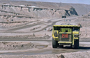
Copper
Copper is a chemical element with the symbol Cu and atomic number 29. It is a ductile metal with very high thermal and electrical conductivity. Pure copper is soft and malleable; an exposed surface has a reddish-orange tarnish...
reserves and is also the largest producer and exporter of the metal. Some well-known copper mines are Chuquicamata
Chuquicamata
Chuquicamata, or "Chuqui" as it is more familiarly known, is by digged volume the biggest open pit copper mine in the world, located in the north of Chile, 215 km northeast of Antofagasta and 1,240 km north of the capital, Santiago...
and Escondida
Escondida
Minera Escondida, which means 'hidden' in Spanish, is a mining company that operates two open pit copper mines in the Atacama Desert, 170 km southeast of Antofagasta in northern Chile. It is currently the highest producing copper mine in the world...
. Chile stands for 5% of the western hemisphere's gold
Gold
Gold is a chemical element with the symbol Au and an atomic number of 79. Gold is a dense, soft, shiny, malleable and ductile metal. Pure gold has a bright yellow color and luster traditionally considered attractive, which it maintains without oxidizing in air or water. Chemically, gold is a...
production of which 41% is a by-product of copper extraction
Copper extraction
Copper extraction techniques refers to the methods for obtaining copper from its ores. This conversion consists of a series of chemical, physical, and electrochemical processes. Methods have evolved and vary with country depending on the ore source, local environmental regulations, and other...
. Apart from copper, Chile contains the largest share of the world reserves of rhenium
Rhenium
Rhenium is a chemical element with the symbol Re and atomic number 75. It is a silvery-white, heavy, third-row transition metal in group 7 of the periodic table. With an average concentration of 1 part per billion , rhenium is one of the rarest elements in the Earth's crust. The free element has...
and potassium nitrate
Potassium nitrate
Potassium nitrate is a chemical compound with the formula KNO3. It is an ionic salt of potassium ions K+ and nitrate ions NO3−.It occurs as a mineral niter and is a natural solid source of nitrogen. Its common names include saltpetre , from medieval Latin sal petræ: "stone salt" or possibly "Salt...
. Chile's reserves of molybdenum
Molybdenum
Molybdenum , is a Group 6 chemical element with the symbol Mo and atomic number 42. The name is from Neo-Latin Molybdaenum, from Ancient Greek , meaning lead, itself proposed as a loanword from Anatolian Luvian and Lydian languages, since its ores were confused with lead ores...
are estimated to be the third largest in the world. While most of Chile's mineral resources are in the north
Norte Grande, Chile
The Norte Grande is one of the five natural regions into which CORFO divided continental Chile in 1950. It borders Peru to the north, the Pacific Ocean to the west, the Altiplano, Bolivia and Argentina to the east, and the Copiapó River to the south, beyond which lies the Norte Chico natural...
, there are gas
Gas
Gas is one of the three classical states of matter . Near absolute zero, a substance exists as a solid. As heat is added to this substance it melts into a liquid at its melting point , boils into a gas at its boiling point, and if heated high enough would enter a plasma state in which the electrons...
, coal
Coal
Coal is a combustible black or brownish-black sedimentary rock usually occurring in rock strata in layers or veins called coal beds or coal seams. The harder forms, such as anthracite coal, can be regarded as metamorphic rock because of later exposure to elevated temperature and pressure...
and oil
Oil
An oil is any substance that is liquid at ambient temperatures and does not mix with water but may mix with other oils and organic solvents. This general definition includes vegetable oils, volatile essential oils, petrochemical oils, and synthetic oils....
reserves in the southern Magallanes Region of significance for local consumption.
Guarello Island
Guarello Island
Guarello Island is an island in Madre de Dios Archipelago in Magallanes Region, Chile. Guarello Island is in a limestone area that also includes Madre de Dios Island. The island has the world's southernmost limestone mine...
in Magallanes Region currently has the world's southernmost limestone
Limestone
Limestone is a sedimentary rock composed largely of the minerals calcite and aragonite, which are different crystal forms of calcium carbonate . Many limestones are composed from skeletal fragments of marine organisms such as coral or foraminifera....
mine.
Geothermal energy
Geothermal exploration and concessions are regulated by the Law of Geothermal ConcessionsLaw of Geothermal Concessions
The Law of Geothermal Concessions is a Chilean law that regulates geothermal energy since 2000. The law deals with geothermal concessions, tenders, security, ownership relations the role of the state in relation to geothermal energy...
(Spanish: Ley de Concesiones de Energía Geotérmica) since 2000. Currently the Chilean company company Geotermia del Pacífico is exploring a concesion right around the locality of Curacautín
Curacautín
Curacautín, which means "Gathering Stone" in Mapudungun, is a commune and city in the Chilean province of Malleco. Curacautín is located 90 kilometres northeast of Temuco, in a valley near the volcanoes Tolhuaca, Lonquimay and Llaima, all of which can be seen from the city...
for building a geothermal power plant with support of CORFO
CORFO
Production Development Corporation is a Chilean governmental organization that was founded in 1939, by President Pedro Aguirre Cerda, to promote economic growth in Chile...
. Geotermia del Paícifco's studies show that two geothermal fields near Curacautín could be used for energy production with combined capacity of supplying 36,000 homes in 2010. One of the geothemal areas to be develpped are located close to the Tolhuaca hotsprings and the other in Río Blanco Springs.
Another area being currently explored for geothermal energy production is Cordón Caulle. In northern Chile El Tatio
El Tatio
thumb|A geyser bubbling at El Tatio geyser fieldEl Tatio is a geyser field located within the Andes Mountains of northern Chile at 4,200 meters above mean sea level. Contrary to some reports, it is not the highest-elevation geyser field in the world. Puchuldiza Geyser Field, Chile, and possibly...
has investigated as early as in the 1920s and was the site of a failed experiment in the 1990s.
Tourism
Tourism focusing on geology is scarce if considering that the natural scenery that attracts many tourist to different locations in Chile is product of geological processes. There are however some sites where geology is made a major attraction, such as in the case of the tourism office of the copper mine ChuquicamataChuquicamata
Chuquicamata, or "Chuqui" as it is more familiarly known, is by digged volume the biggest open pit copper mine in the world, located in the north of Chile, 215 km northeast of Antofagasta and 1,240 km north of the capital, Santiago...
. National parks all over Chile have considerable amount of information about flora and fauna but notably often lacks geological information. Santuario de la Naturaleza Granito Orbicular
Orbicular Granite
Orbicular granite is an uncommon plutonic rock type which is usually granitic in composition. These rocks have a unique appearance due to orbicules - concentrically layered, spheroidal structures, probably formed through nucleation around a grain in a cooling magma chamber...
is one of the few protected areas in Chile where tourism centres around the particular geology of the place.
Geological hazards
Due to the tectonic setting of Chile earthquakeEarthquake
An earthquake is the result of a sudden release of energy in the Earth's crust that creates seismic waves. The seismicity, seismism or seismic activity of an area refers to the frequency, type and size of earthquakes experienced over a period of time...
s, volcanic eruptions and mass movements
Mass wasting
Mass wasting, also known as slope movement or mass movement, is the geomorphic process by which soil, regolith, and rock move downslope under the force of gravity. Types of mass wasting include creep, slides, flows, topples, and falls, each with its own characteristic features, and taking place...
are frequent. The subduction zone along Chile's coast has produced the most powerful earthquake ever recorded, the 1960 Valdivia earthquake. Earthquakes are known to have triggered eruption at volcanoes as it happened in 1960 with Cordón Caulle. Earthquakes have also produced tsunamis and even earthquakes on the other side of the Pacific Ocean have the potential of sending a tsuname wave to Chile.
Landslides may occur with some frequency in Andes of central and southern Chile, most events happens following earthquakes. The 2007 Aysen Fjord earthquake produced several landslides along the fjords mountains producing thus big tsunami-like waves inside the fjord.
Mud flows are also common in some places and occur after large rainfall events. Lahar
Lahar
A lahar is a type of mudflow or debris flow composed of a slurry of pyroclastic material, rocky debris, and water. The material flows down from a volcano, typically along a river valley. The term is a shortened version of "berlahar" which originated in the Javanese language of...
s have been are among the most lethal volcanic hazards in Chile, destroying towns such as Coñaripe
Coñaripe
Coñaripe is a Chilean town and resort area, located on the shore of Calafquén Lake. Administratively it belongs to Panguipulli commune in Valdivia Province of Los Ríos Region....
in 1964. Although many lahars are triggered by volcanic eruptions they are often mistaken as unequivocal sign of eruption, which is not the case.
Earthquakes
Seismicity of the Chilean coast identifies and describes the seismic activity of an area of ChileChile
Chile ,officially the Republic of Chile , is a country in South America occupying a long, narrow coastal strip between the Andes mountains to the east and the Pacific Ocean to the west. It borders Peru to the north, Bolivia to the northeast, Argentina to the east, and the Drake Passage in the far...
. Seismicity refers to the frequency, type and size of earthquakes experienced over a period of time. The Chilean coast is southern part of South America which is near a Pacific Ocean subduction zone.
Major earthquakes in Chile occur in a small number of source areas. Those which affect coastal regions are aligned offshore from Concepción to the south. The major epicenters produce a predictable pattern of seismic and tsunami effects.
The first systematic seismology of Chile began after an earthquake and fire devastated Valparaiso in 1906.
Significant events which devastated coastal communities in the 20th and 21st centuries include:
- 1906 Valparaiso earthquake1906 Valparaíso earthquakeThe 1906 Valparaíso earthquake was a strong earthquake that hit Valparaíso, Chile, on August 16, 1906 at 19:55 local time. Its epicenter was offshore from the Valparaíso Region, and its intensity was estimated at magnitude 8.2 MW....
. The 8.8 Chilean quake in August was preceded by the Ecuador-Columbia quake1906 Ecuador-Colombia earthquakeThe 1906 Ecuador-Colombia earthquake occurred at 15:36 UTC on January 31, off the coast of Ecuador, near Esmeraldas. The earthquake had a magnitude of 8.8 and triggered a destructive tsunami that caused at least 500 casualties on the coast of Colombia....
(8.8 magnitude) in January and the San Francisco quake1906 San Francisco earthquakeThe San Francisco earthquake of 1906 was a major earthquake that struck San Francisco, California, and the coast of Northern California at 5:12 a.m. on Wednesday, April 18, 1906. The most widely accepted estimate for the magnitude of the earthquake is a moment magnitude of 7.9; however, other...
(7.9 magnitude) in April. - 1960 Valdivia earthquake. The 9.5-magnitude quake in Chile (largest in modern history) was comparable in scale to earthquakes in Alaska (2nd largest) and the Kamchatka Peninsula (5th largest).
- 2010 Chile earthquake2010 Chile earthquakeThe 2010 Chile earthquake occurred off the coast of central Chile on Saturday, 27 February 2010, at 03:34 local time , having a magnitude of 8.8 on the moment magnitude scale, with intense shaking lasting for about three minutes. It ranks as the sixth largest earthquake ever to be recorded by a...
. The 8.8-magnitude quake in Chile (6th largest) was comparable in scale to undersea seismic events near Indonesia in 2004 (3rd largest) and near Japan in 20112011 Tōhoku earthquake and tsunamiThe 2011 earthquake off the Pacific coast of Tohoku, also known as the 2011 Tohoku earthquake, or the Great East Japan Earthquake, was a magnitude 9.0 undersea megathrust earthquake off the coast of Japan that occurred at 14:46 JST on Friday, 11 March 2011, with the epicenter approximately east...
(4th largest).
The seismicity of the Chilean coast and the top six quakes ever recorded appear to be clustered in two time periods: a 12-year span between 1952 and 1964 and a 7-year span between the 2004 and 2011; however, this is understood as a statistical anomaly
The phenonmenon comparably large quakes that happen on the same or neighbouring faults within months of each other can be explained by a sound geological mechanism; but this does not fully demonstrate a relationship between events separated by longer periods and greater distances
See also
- Climate of ChileClimate of ChileThe climate of Chile comprises a wide range of weather conditions across a large geographic scale, extending across 38 degrees in latitude, making generalisations difficult...
- Geography of ChileGeography of ChileImage:Chilenav.gif|thumb|417px|left|Click over the map to obtain a topographic map of the region and its toponymyrect 23 14 119 35 rect 23 35 119 44 rect 23 44 119 54 rect 23 54 119 65 rect 23 65 119 75 rect 23 75 119 85...
- Glaciers of ChileGlaciers of ChileThe glaciers of Chile cover 2.7% of the land area of the country, excluding Antártica Chilena, and have a considerable impact on its landscape and water supply. By surface 80% of South America's glaciers lie in Chile...
- List of earthquakes in Chile
- List of volcanoes in Chile
Sources
- Brüggen, Juan. Fundamentos de la geología de Chile, Instituto Geográfico Militar 1950.
- Duhart, Paul et al. El Complejo Metamórfico Bahía Mansa en la cordillera de la Costa del centro-sur de Chile (39°30'-42°00'S): geocronología K-Ar, 40Ar/39Ar y U-Pb e implicancias en la evolución del margen sur-occidental de Gondwana