

Zona Sur
Encyclopedia
The Zona Sur is one of the five natural region
Natural region
A Natural region is one which is distinguished by its natural features of geography and usually more important, geology. The natural ecology of the region is likely to be significant but one of these factors tends to influence the others....
s on which CORFO
CORFO
Production Development Corporation is a Chilean governmental organization that was founded in 1939, by President Pedro Aguirre Cerda, to promote economic growth in Chile...
divided continental Chile
Chile
Chile ,officially the Republic of Chile , is a country in South America occupying a long, narrow coastal strip between the Andes mountains to the east and the Pacific Ocean to the west. It borders Peru to the north, Bolivia to the northeast, Argentina to the east, and the Drake Passage in the far...
in 1950. Its northern border is formed by the Bío-Bío River
Bío-Bío River
The Biobío River is the second largest river in Chile. It originates from Icalma and Galletué lakes in the Andes and flows 380 km to the Gulf of Arauco on the Pacific Ocean....
, the limit with the Central Chile Zone. By west with the Pacific Ocean
Pacific Ocean
The Pacific Ocean is the largest of the Earth's oceanic divisions. It extends from the Arctic in the north to the Southern Ocean in the south, bounded by Asia and Australia in the west, and the Americas in the east.At 165.2 million square kilometres in area, this largest division of the World...
, by the east with the Andean mountains and Argentina
Argentina
Argentina , officially the Argentine Republic , is the second largest country in South America by land area, after Brazil. It is constituted as a federation of 23 provinces and an autonomous city, Buenos Aires...
. Its southern border is the Chacao Channel
Chacao Channel
The Chacao Channel is located in Los Lagos Region, Chile and separates Chiloé Island from mainland Chile. The channel was created during the Quaternary glaciations by successive glaciers that flowed down fron the Andes to the coast...
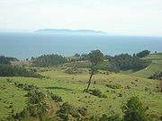
, beyond it lies the Austral Zone. While Chiloé Archipelago
Chiloé Archipelago
Chiloé Archipelago consists of several islands lying off the coast of Chile. It is separated from mainland Chile by Chacao Channel in the north, the Sea of Chiloé in the east and Gulf of Corcovado to the southeast. All of the archipelago except Desertores Islands, which are part of Palena...
belongs geographically to Zona Austral in terms of culture and history it lies closer to Zona Sur.
Geography
Although many lovely lakes can be found in the Andean and coastal regions of central Chile, the south (Sur de Chile) is definitely the country's most lacustrine area. Southern Chile stretches from below the Río Bío-BíoBío-Bío River
The Biobío River is the second largest river in Chile. It originates from Icalma and Galletué lakes in the Andes and flows 380 km to the Gulf of Arauco on the Pacific Ocean....
at about 37° south latitude to below Isla de Chiloé
Chiloé Island
Chiloé Island , also known as Greater Island of Chiloé , is the largest island of the Chiloé Archipelago off the coast of Chile, in the Pacific Ocean...
at about 43.4° south latitude. In this lake district of Chile, the valley between the Andes and the coastal range
Chilean Coast Range
The Chilean Coastal Range is a mountain range that runs from north to south along the Pacific coast of South America parallel to the Andean Mountains, extending from Morro de Arica in the north to Taitao Peninsula, where it ends at the Chile Triple Junction, in the south. The range has a strong...
is closer to sea level, and the hundreds of rivers that descend from the Andes form lakes, some quite large, as they reach the lower elevations. They drain into the ocean through other rivers, some of which (principally the Calle-Calle River
Calle-Calle River
Calle-Calle River also called Gudalafquén in Mapudungun, is a river in Valdivia Province, southern Chile. It drains waters from the San Pedro River to the Valdivia River, which in turn flows into Corral Bay on the Pacific Ocean.The Calle-Calle is the only river in Chile that is considered...
, which flows by the city of Valdivia
Valdivia, Chile
Valdivia is a city and commune in southern Chile administered by the Municipality of Valdivia. The city is named after its founder Pedro de Valdivia and is located at the confluence of the Calle-Calle, Valdivia and Cau-Cau Rivers, approximately east of the coastal towns of Corral and Niebla...
) are the only ones in the whole country that are navigable for any stretch. The Central Valley's southernmost portion is submerged in the ocean and forms the Golfo de Ancud. Isla de Chiloé
Chiloé Island
Chiloé Island , also known as Greater Island of Chiloé , is the largest island of the Chiloé Archipelago off the coast of Chile, in the Pacific Ocean...
, with its rolling hills, is the last important elevation of the coastal range of mountains.
The lakes in this region are remarkably beautiful. The snow covered Andes form a constant backdrop to vistas of clear blue or even turquoise waters, as at Lago Todos los Santos
Todos los Santos Lake
Lake Todos los Santos is a lake located in the Los Lagos Region of southern Chile, 96 km northeast of the regional capital Puerto Montt and 76 km east of Puerto Varas, within the boundaries of the Vicente Pérez Rosales National Park. It has a surface area of 178.5 km² and a maximum depth of 337 m...
. The rivers that descend from the Andes rush over volcanic rocks, forming numerous white-water sections and waterfalls. The vegetation, including many ferns in the shady areas, is a lush green. Some sections still consist of old-growth forests, and in all seasons, but especially in the spring and summer, there are plenty of wildflowers and flowering trees. The pastures in the northernmost section, around Osorno
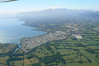
Osorno, Chile
Osorno is a city and commune in southern Chile and capital of Osorno Province in the Los Lagos Region. It had a population of 145,475, as of the 2002 census...
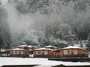
, are well suited for raising cattle; milk, cheese, and butter are important products of that area. All kinds of berries grow in the area, some of which are exported, and freshwater farming of various species of trout and salmon has developed, with cultivators taking advantage of the abundant supply of clear running water. The lumber industry is also important. A number of tourists, mainly Chileans and Argentines, visit the area during the summer.
Climate
The south is one of the rainiest areas in the world. One of the wettest spots in the region is Valdivia, with an annual rainfall of 2,535.4 millimeters. The summer months of January and February are the driest, with a monthly average precipitation of sixty-seven millimeters. The winter months of June and July each produce on average a deluge of 410.6 millimeters. Temperatures in the area are moderate. In Valdivia, the two summer months average 16.7 °C, whereas the winter months average 7.9 °C.Flora and fauna
Many of Chile's distinctive animal species have been decimated as they have been pushed farther and farther into the remaining wilderness areas by human occupation of the land. This is the case with the huemulHuemul
Huemul may refer to:* The South Andean deer* Huemul Island * Huemul Project...
, a large deer, and the Chilean condor
Condor
Condor is the name for two species of New World vultures, each in a monotypic genus. They are the largest flying land birds in the Western Hemisphere.They are:* The Andean Condor which inhabits the Andean mountains....
, the largest bird of its kind; both animals are on the national coat of arms. The remaining Chilean cougars, which are bigger than their California cousins, have been driven to isolated national parks in the south by farmers who continue to hunt them because they occasionally kill sheep and goats.
History
Southern Chile was during the time of Spanish conquest and colony populated by indigenous MapucheMapuche
The Mapuche are a group of indigenous inhabitants of south-central Chile and southwestern Argentina. They constitute a wide-ranging ethnicity composed of various groups who shared a common social, religious and economic structure, as well as a common linguistic heritage. Their influence extended...
s from Toltén River
Toltén River
Toltén River is a river located in the Araucanía Region of Chile. It rises at Villarrica Lake, close to the city of the same name. Its major tributary is Allipén River...
northwards and by Huilliche
Huilliche
The Huilliche is an ethnic group of Chile, belonging to the Mapuche culture. They live in mountain valleys in an area south of Toltén River and on Chiloé Archipelago...
s south of the river, both groups are classified as Araucanian. The mountainous zones in the east were populated by Pehuenche
Pehuenche
Pehuenches are an indigenous people that are part of the Mapuche peoples and live in the Andes in south central Chile and Argentina. Their name derives from their habit of harvesting of piñones, the seeds of the Araucaria araucana or pehuén...
s Puelche
Puelche
Puelche is the name that the Mapuche used to give the ethnic groups who inhabited the lands to the east of the Andes Mountains including the northern Tehuelches and Hets, these last ones were also known as the Pampas or Querandíes...
s. Until the Disaster of Curalaba
Disaster of Curalaba
The Disaster of Curalaba is the name given to a battle between Spanish conquerors led by Martín García Óñez de Loyola and Mapuche people led by Pelantaru on a place called Curalaba , in southern Chile...
and the following Destruction of Seven Cities
Destruction of Seven Cities
The Destruction of the Seven Cities in Araucanía was a result of the great Mapuche revolt in 1598. It is considered sometimes as the end of the Conquest of Chile...
around 1600 the southern zone was part of the General Captaincy of Chile and Spanish Empire. After 1600, the Spanish settlements were destroyed or abandoned with the exception of Valdivia
Valdivia, Chile
Valdivia is a city and commune in southern Chile administered by the Municipality of Valdivia. The city is named after its founder Pedro de Valdivia and is located at the confluence of the Calle-Calle, Valdivia and Cau-Cau Rivers, approximately east of the coastal towns of Corral and Niebla...
that was re-founded in 1645 with heavy fortifications. The zone between Valdivia and Chiloé was gradually incorporated into Chile by a series of agreements with local Huilliches and founding of settlements. By 1850 this process was culminated with the immigration of thousands of German immigrants to Valdivia, Osorno and Llanquihue. The zone north of Valdivia was incorporated into Chile in the 1880s during the occupation of the Araucania
Occupation of the Araucanía
The Occupation of Araucanía was a series of military campaigns, agreements and penetrations by the Chilean army and settlers which led to the incorporation of Araucanía into Chilean national territory...
.