

U.S. Route 26 in Oregon
Encyclopedia
In the U.S. state
of Oregon
, U.S. Route 26
is a major cross-state state highway
, connecting U.S. Route 101
on the Oregon Coast
near Seaside
with the Idaho
state line east of Nyssa. Local highway names (see Oregon highways and routes) include the Sunset Highway No. 47, Mount Hood Highway No. 26, and John Day Highway No. 5.
near Seaside
to Portland
. (Prior to 2004, its origin was near Astoria
and continued south to Seaside concurrent with US 101.) The Sunset Highway becomes a freeway near Banks
, serving Washington County
suburb
s of Portland
such as North Plains
, Hillsboro
, and Beaverton
.
 In Portland, the route overlaps Interstate 405
(Stadium Freeway No. 61) for a short distance before exiting onto city streets, including Arthur Street, to reach the Ross Island Bridge
. (Prior to 2005, US 26 ran through downtown Portland on the one-way couplet of Market and Clay Streets, which carry the Sunset Highway to its end at Naito Parkway (Pacific Highway West No. 1W), turning south there to reach the bridge.) US 26 leaves the bridge, which is at the beginning of the Mount Hood Highway No. 26, and follows Powell Boulevard, a surface street, to Gresham
.
There were plans to construct a freeway alignment of US 26 — the Mount Hood Freeway — to bypass Powell Boulevard; however this project was canceled as a result of the freeway revolts in the 1970s. A few ramp stubs from Interstate 5 (on the Marquam Bridge) stand as evidence of this project. Roadway connections between the Portland freeway network and Mount Hood
remain a big problem, as there is no good direct highway connection. The proposed Sunrise Corridor may eventually offer a long-term solution; however construction of this route is several years off.
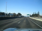
An expressway
begins near Gresham and carries US 26 southeast to near Sandy
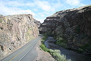
. From Sandy to near Government Camp and Bennett Pass, where US 26 intersects Oregon Route 35, it closely follows the historic Barlow Road
through the Mount Hood Corridor, and is part of the Mount Hood Scenic Byway. The Mount Hood Highway branches off to the north along OR 35, and the Warm Springs Highway No. 53 carried US 26 southeast through Blue Box Pass, the Warm Springs Indian Reservation
, and Agency Plains
to Madras
. After a short overlap with US 97
(The Dalles-California Highway No. 4), the short Madras-Prineville Highway No. 360 continues southeast to a junction with OR 126 in Prineville
.
At that junction, US 26 picks up the Ochoco Highway No. 41, which also follows OR 126 west to US 97 in Redmond
. The Ochoco Highway ends at OR 19
near Dayville
, from which US 26 follows the John Day Highway No. 5 through John Day
to US 20
in Vale
. The remainder of US 26 in Oregon overlaps US 20 on the Central Oregon Highway No. 7 to the Idaho state line.
 An ancient trail passed through the section of the Warm Springs Indian Reservation
as part of an extensive Indian
trade network linking peoples of the northern Great Basin
and Columbia Plateau
to those living west of the Cascade Range
. Obsidian
, bear grass, and slaves were transported over these trails to major trading locations along the Columbia River
in exchange for dried salmon
, smelt, sturgeon
, and decorative sea shells. The long established route was later used by Peter Skene Ogden
's fur trapping expeditions in 1825 and 1826. Fur trader Nathaniel Wyeth
was here in the 1830s. Captain John C. Frémont
followed this route on his 1843 explorations for the United States and Lieutenant Henry Larcom Abbot
headed a Pacific Railroad
survey
party along it in 1855.
U.S. state
A U.S. state is any one of the 50 federated states of the United States of America that share sovereignty with the federal government. Because of this shared sovereignty, an American is a citizen both of the federal entity and of his or her state of domicile. Four states use the official title of...
of Oregon
Oregon
Oregon is a state in the Pacific Northwest region of the United States. It is located on the Pacific coast, with Washington to the north, California to the south, Nevada on the southeast and Idaho to the east. The Columbia and Snake rivers delineate much of Oregon's northern and eastern...
, U.S. Route 26
U.S. Route 26
U.S. Route 26 is an east–west United States highway. It started in Ogallala, Nebraska, and gradually grew to reach the West Coast in Oregon. When the U.S. highway system was first defined, it was limited to Nebraska and Wyoming; by the 1950s, it continued into Idaho and Oregon. The...
is a major cross-state state highway
State highway
State highway, state road or state route can refer to one of three related concepts, two of them related to a state or provincial government in a country that is divided into states or provinces :#A...
, connecting U.S. Route 101
U.S. Route 101 in Oregon
In the U.S. state of Oregon, U.S. Route 101, a major north–south U.S. Highway, runs through the state along the coastline near the Pacific Ocean. In Oregon, it runs from the Oregon–California border, south of Brookings, to the Oregon–Washington border on the Columbia River, between Astoria,...
on the Oregon Coast
Oregon Coast
The Oregon Coast is a region of the U.S. state of Oregon. It runs generally north-south along the Pacific Ocean, forming the western border of the state; the region is bounded to the east by the Oregon Coast Range. The Oregon Coast stretches approximately from the Columbia River in the north to...
near Seaside
Seaside, Oregon
Seaside is a city in Clatsop County, Oregon, United States. The name Seaside is derived from Seaside House, a historic summer resort built in the 1870s by railroad magnate Ben Holladay. The city's population was 6,457 at the 2010 census.-History:...
with the Idaho
Idaho
Idaho is a state in the Rocky Mountain area of the United States. The state's largest city and capital is Boise. Residents are called "Idahoans". Idaho was admitted to the Union on July 3, 1890, as the 43rd state....
state line east of Nyssa. Local highway names (see Oregon highways and routes) include the Sunset Highway No. 47, Mount Hood Highway No. 26, and John Day Highway No. 5.
Route description
The westernmost segment, known as the Sunset Highway No. 47, heads southeast from US 101U.S. Route 101 in Oregon
In the U.S. state of Oregon, U.S. Route 101, a major north–south U.S. Highway, runs through the state along the coastline near the Pacific Ocean. In Oregon, it runs from the Oregon–California border, south of Brookings, to the Oregon–Washington border on the Columbia River, between Astoria,...
near Seaside
Seaside, Oregon
Seaside is a city in Clatsop County, Oregon, United States. The name Seaside is derived from Seaside House, a historic summer resort built in the 1870s by railroad magnate Ben Holladay. The city's population was 6,457 at the 2010 census.-History:...
to Portland
Portland, Oregon
Portland is a city located in the Pacific Northwest, near the confluence of the Willamette and Columbia rivers in the U.S. state of Oregon. As of the 2010 Census, it had a population of 583,776, making it the 29th most populous city in the United States...
. (Prior to 2004, its origin was near Astoria
Astoria, Oregon
Astoria is the county seat of Clatsop County, Oregon, United States. Situated near the mouth of the Columbia River, the city was named after the American investor John Jacob Astor. His American Fur Company founded Fort Astoria at the site in 1811...
and continued south to Seaside concurrent with US 101.) The Sunset Highway becomes a freeway near Banks
Banks, Oregon
Banks is a city in Washington County, Oregon, United States. The population was 1,777 at the 2010 census. The community was named for settler Robert Banks and his father, John Banks.-Geography:...
, serving Washington County
Washington County, Oregon
- Major highways :* Interstate 5* Interstate 205* U.S. Route 26* Oregon Route 6* Oregon Route 8* Oregon Route 10* Oregon Route 47* Oregon Route 99W* Oregon Route 210* Oregon Route 217* Oregon Route 219-Demographics:...
suburb
Suburb
The word suburb mostly refers to a residential area, either existing as part of a city or as a separate residential community within commuting distance of a city . Some suburbs have a degree of administrative autonomy, and most have lower population density than inner city neighborhoods...
s of Portland
Portland, Oregon
Portland is a city located in the Pacific Northwest, near the confluence of the Willamette and Columbia rivers in the U.S. state of Oregon. As of the 2010 Census, it had a population of 583,776, making it the 29th most populous city in the United States...
such as North Plains
North Plains, Oregon
North Plains is a city in Washington County, Oregon, United States, off U.S. 26 on the northwest outskirts of the Portland metropolitan area. The population was 1,605 at the 2000 census; by July 2007 the population was estimated to be 1,813.-Geography:...
, Hillsboro
Hillsboro, Oregon
Hillsboro is the fifth-largest city in the U.S. state of Oregon and is the county seat of Washington County. Lying in the Tualatin Valley on the west side of the Portland metropolitan area, the city is home to many high-technology companies, such as Intel, that compose what has become known as the...
, and Beaverton
Beaverton, Oregon
Beaverton is a city in Washington County, Oregon, United States, seven miles west of Portland in the Tualatin River Valley.As of the 2010 census, the population is 90,267. This makes it the second-largest city in the county and Oregon's sixth-largest city...
.
Interstate 405 (Oregon)
Interstate 405 is a short Interstate Highway in Portland, Oregon. It forms a loop from Interstate 5 that travels through downtown Portland west of the Willamette River.-Route description:...
(Stadium Freeway No. 61) for a short distance before exiting onto city streets, including Arthur Street, to reach the Ross Island Bridge
Ross Island Bridge
The Ross Island Bridge is a cantilever truss bridge that spans the Willamette River in Portland, Oregon. It carries U.S. Route 26 across the river between southwest and southeast Portland...
. (Prior to 2005, US 26 ran through downtown Portland on the one-way couplet of Market and Clay Streets, which carry the Sunset Highway to its end at Naito Parkway (Pacific Highway West No. 1W), turning south there to reach the bridge.) US 26 leaves the bridge, which is at the beginning of the Mount Hood Highway No. 26, and follows Powell Boulevard, a surface street, to Gresham
Gresham, Oregon
- Demographics :As of the census of 2000, there were 90,205 people, 33,327 households, and 22,695 families residing in the city. The population density was 4,071.6 people per square mile . There were 35,309 housing units at an average density of 1,593.8 per square mile...
.
There were plans to construct a freeway alignment of US 26 — the Mount Hood Freeway — to bypass Powell Boulevard; however this project was canceled as a result of the freeway revolts in the 1970s. A few ramp stubs from Interstate 5 (on the Marquam Bridge) stand as evidence of this project. Roadway connections between the Portland freeway network and Mount Hood
Mount Hood
Mount Hood, called Wy'east by the Multnomah tribe, is a stratovolcano in the Cascade Volcanic Arc of northern Oregon. It was formed by a subduction zone and rests in the Pacific Northwest region of the United States...
remain a big problem, as there is no good direct highway connection. The proposed Sunrise Corridor may eventually offer a long-term solution; however construction of this route is several years off.
An expressway
Limited-access road
A limited-access road known by various terms worldwide, including limited-access highway, dual-carriageway and expressway, is a highway or arterial road for high-speed traffic which has many or most characteristics of a controlled-access highway , including limited or no access to adjacent...
begins near Gresham and carries US 26 southeast to near Sandy
Sandy, Oregon
Sandy is a city located in Clackamas County, Oregon, United States, and named after the nearby Sandy River. As of the 2000 census, the city had a total population of 5,385, however the 2006 estimate shows 7,070 people....
. From Sandy to near Government Camp and Bennett Pass, where US 26 intersects Oregon Route 35, it closely follows the historic Barlow Road
Barlow Road
The Barlow Road is a historic road in what is now the U.S. state of Oregon. It was built in 1846 by Sam Barlow and Philip Foster, with authorization of the Provisional Legislature of Oregon, and served as the last overland segment of the Oregon Trail...
through the Mount Hood Corridor, and is part of the Mount Hood Scenic Byway. The Mount Hood Highway branches off to the north along OR 35, and the Warm Springs Highway No. 53 carried US 26 southeast through Blue Box Pass, the Warm Springs Indian Reservation
Warm Springs Indian Reservation
The Warm Springs Indian Reservation consists of 1,019.385 sq mi in north central Oregon, in the United States, and is occupied and governed by the Confederated Tribes of Warm Springs.-Tribes:...
, and Agency Plains
Agency Plains (Oregon)
Agency Plains is a plateau just north of the city of Madras, Oregon, United States. It extends approximately north to south and east to west some in elevation above the east side of the Deschutes River. The area is composed of arable land and was the homestead area of the Guard, Campbell, and...
to Madras
Madras, Oregon
Madras is a city in Jefferson County, Oregon, United States. Originally called The Basin after the circular valley the city is located in, it is unclear as to whether Madras was named in 1903 for the cotton fabric called "Madras" that originated in the Madras area in India, or from the city of...
. After a short overlap with US 97
U.S. Route 97 in Oregon
In the U.S. state of Oregon, U.S. Route 97 is a major north–south United States highway which runs through the state of Oregon . In Oregon, it runs from the Oregon-California border, south of Klamath Falls, to the Oregon-Washington border on the Columbia River, between Biggs Junction, Oregon and...
(The Dalles-California Highway No. 4), the short Madras-Prineville Highway No. 360 continues southeast to a junction with OR 126 in Prineville
Prineville, Oregon
Prineville is a city in and the county seat of Crook County, Oregon, United States. It was named for the first merchant located in the present location, Barney Prine. The population was 9,253 at the 2010 census.- History :...
.
At that junction, US 26 picks up the Ochoco Highway No. 41, which also follows OR 126 west to US 97 in Redmond
Redmond, Oregon
Redmond is a city in Deschutes County, Oregon, United States. Incorporated on July 6, 1910, the city is located on the eastern side of Oregon's Cascade Range, in the High Desert, and is considered the geographical heart of Central Oregon...
. The Ochoco Highway ends at OR 19
Oregon Route 19
Oregon Route 19 is an Oregon state highway in the north-central part of the state. It runs from Interstate 84 at Arlington in the Columbia River Gorge to a junction with U.S. Route 26 in Grant County, near the Sheep Rock Unit of the John Day Fossil Beds National Monument. Oregon Route 19 is the...
near Dayville
Dayville, Oregon
Dayville is a city in Grant County, Oregon, United States. It was incorporated in 1913. The population was 138 at the 2000 census.-Geography:According to the United States Census Bureau, the city has a total area of , all land....
, from which US 26 follows the John Day Highway No. 5 through John Day
John Day, Oregon
John Day is a city located about north of Canyon City in Grant County, Oregon, at the intersection of U.S. Routes 26 and 395. The city was named for the nearby John Day River, which had been named for a Virginian member of the 1811 Astor Expedition, John Day...
to US 20
U.S. Route 20 in Oregon
U.S. Route 20 in Oregon is a major east–west cross-state highway, especially east of the Cascade Mountains. It connects U.S. Route 101 in Newport on the central Oregon Coast to the Idaho state line east of Nyssa.- Route description :...
in Vale
Vale, Oregon
Vale is a city in Malheur County, Oregon, United States, about west of the Idaho border. It is at the intersection of U.S. Routes 20 and 26, on the Malheur River.Vale was selected as Malheur's county seat in 1955, 68 years after the county was founded...
. The remainder of US 26 in Oregon overlaps US 20 on the Central Oregon Highway No. 7 to the Idaho state line.
History
Warm Springs Indian Reservation
The Warm Springs Indian Reservation consists of 1,019.385 sq mi in north central Oregon, in the United States, and is occupied and governed by the Confederated Tribes of Warm Springs.-Tribes:...
as part of an extensive Indian
Native Americans in the United States
Native Americans in the United States are the indigenous peoples in North America within the boundaries of the present-day continental United States, parts of Alaska, and the island state of Hawaii. They are composed of numerous, distinct tribes, states, and ethnic groups, many of which survive as...
trade network linking peoples of the northern Great Basin
Great Basin
The Great Basin is the largest area of contiguous endorheic watersheds in North America and is noted for its arid conditions and Basin and Range topography that varies from the North American low point at Badwater Basin to the highest point of the contiguous United States, less than away at the...
and Columbia Plateau
Columbia Plateau
The Columbia Plateau is a geologic and geographic region that lies across parts of the U.S. states of Washington, Oregon, and Idaho. It is a wide flood basalt plateau between the Cascade Range and the Rocky Mountains, cut through by the Columbia River...
to those living west of the Cascade Range
Cascade Range
The Cascade Range is a major mountain range of western North America, extending from southern British Columbia through Washington and Oregon to Northern California. It includes both non-volcanic mountains, such as the North Cascades, and the notable volcanoes known as the High Cascades...
. Obsidian
Obsidian
Obsidian is a naturally occurring volcanic glass formed as an extrusive igneous rock.It is produced when felsic lava extruded from a volcano cools rapidly with minimum crystal growth...
, bear grass, and slaves were transported over these trails to major trading locations along the Columbia River
Columbia River
The Columbia River is the largest river in the Pacific Northwest region of North America. The river rises in the Rocky Mountains of British Columbia, Canada, flows northwest and then south into the U.S. state of Washington, then turns west to form most of the border between Washington and the state...
in exchange for dried salmon
Salmon
Salmon is the common name for several species of fish in the family Salmonidae. Several other fish in the same family are called trout; the difference is often said to be that salmon migrate and trout are resident, but this distinction does not strictly hold true...
, smelt, sturgeon
Sturgeon
Sturgeon is the common name used for some 26 species of fish in the family Acipenseridae, including the genera Acipenser, Huso, Scaphirhynchus and Pseudoscaphirhynchus. The term includes over 20 species commonly referred to as sturgeon and several closely related species that have distinct common...
, and decorative sea shells. The long established route was later used by Peter Skene Ogden
Peter Skene Ogden
Peter Skene Ogden , was a fur trader and a Canadian explorer of what is now British Columbia and the American West...
's fur trapping expeditions in 1825 and 1826. Fur trader Nathaniel Wyeth
Nathaniel Jarvis Wyeth
Nathaniel Jarvis Wyeth was an American inventor, ice harvester, and explorer and trader in the far west.-Early life:Wyeth was born in Cambridge, Massachusetts, to Jacob and Elizabeth Wyeth...
was here in the 1830s. Captain John C. Frémont
John C. Frémont
John Charles Frémont , was an American military officer, explorer, and the first candidate of the anti-slavery Republican Party for the office of President of the United States. During the 1840s, that era's penny press accorded Frémont the sobriquet The Pathfinder...
followed this route on his 1843 explorations for the United States and Lieutenant Henry Larcom Abbot
Henry Larcom Abbot
Henry Larcom Abbot was a military engineer and officer in the United States Army.-Early life:Henry Larcom Abbot was born in Beverly, Massachusetts. Abbot attended West Point and graduated second in his class with a degree in military engineering in 1854...
headed a Pacific Railroad
Pacific Railroad
The Pacific Railroad was a railroad based in the U.S. state of Missouri. It was a predecessor of both the Missouri Pacific Railroad and St. Louis-San Francisco Railway.The Pacific was chartered by Missouri in 1849 to extend "from St...
survey
Surveying
See Also: Public Land Survey SystemSurveying or land surveying is the technique, profession, and science of accurately determining the terrestrial or three-dimensional position of points and the distances and angles between them...
party along it in 1855.
Major intersections
- Note: US 26 uses many different highways (see Oregon highways and routes); the milepoint column shows mileage along these highways, not adjusted for equations, with the highway number in front.
County Location Milepoint # Exit numberAn exit number is a number assigned to a road junction, usually an exit from a freeway. It is usually marked on the same sign as the destinations of the exit, as well as a sign in the gore....Destinations Notes Clatsop Clatsop County, OregonClatsop County is a county located in the U.S. state of Oregon. The county is named for the Clatsop tribe of Native Americans, who lived along the coast of the Pacific Ocean prior to European settlement. As of 2010, the population was 37,039. The county seat is Astoria.-Economy:The principal...Cannon Beach Junction 47 -0.10 Interchange Necanicum Junction 47 9.42 Jewell Junction Jewell Junction, OregonJewell Junction is a highway junction and unincorporated locale in Clatsop County, Oregon, United States. It is located at the intersection of U.S. Route 26 and Oregon Route 103, about 9 miles southwest of Jewell.-References:...47 21.78 Interchange Washington Washington County, Oregon- Major highways :* Interstate 5* Interstate 205* U.S. Route 26* Oregon Route 6* Oregon Route 8* Oregon Route 10* Oregon Route 47* Oregon Route 99W* Oregon Route 210* Oregon Route 217* Oregon Route 219-Demographics:...Staleys Junction 47 45.51 West end of OR 47 overlap Davies Junction 47 49.47 Interchange; east end of OR 47 overlap Tillamook Junction 47 53.33 Interchange; no westbound entrance 47 53.62 West end of freeway 47 55.19 55 Dersham Road – Mountaindale Mountaindale, OregonMountaindale is an unincorporated community in Washington County, Oregon, United States, about four miles northwest of North Plains. Settled in the 1850s, the small community was the longtime home of the Mountaindale Store.-History:...North Plains North Plains, OregonNorth Plains is a city in Washington County, Oregon, United States, off U.S. 26 on the northwest outskirts of the Portland metropolitan area. The population was 1,605 at the 2000 census; by July 2007 the population was estimated to be 1,813.-Geography:...47 57.16 57 Glencoe Road – North Plains North Plains, OregonNorth Plains is a city in Washington County, Oregon, United States, off U.S. 26 on the northwest outskirts of the Portland metropolitan area. The population was 1,605 at the 2000 census; by July 2007 the population was estimated to be 1,813.-Geography:...47 58.74 59 Jackson School Road Hillsboro Hillsboro, OregonHillsboro is the fifth-largest city in the U.S. state of Oregon and is the county seat of Washington County. Lying in the Tualatin Valley on the west side of the Portland metropolitan area, the city is home to many high-technology companies, such as Intel, that compose what has become known as the...47 61.06 61 Helvetia Road, Shute Road 47 62.46 62 Cornelius Pass Road Cornelius Pass RoadCornelius Pass Road is an arterial road over Cornelius Pass in the Tualatin Mountains west of Portland, Oregon, USA. Running north–south, the road stretches between U.S. Route 30 on the north and Oregon Route 8 on the south...
– Cornelius Pass, West UnionWest Union, OregonWest Union is an unincorporated community in Washington County, Oregon, United States. Founded in 1851, the community had the first school district in the county, and also contains the oldest cemetery in the state and the oldest Baptist church west of the Rocky Mountains...Signed as exits 62A (south) and 62B (north) westbound 47 64.29 64 185th Avenue – PCC-Rock Creek Beaverton Beaverton, OregonBeaverton is a city in Washington County, Oregon, United States, seven miles west of Portland in the Tualatin River Valley.As of the 2010 census, the population is 90,267. This makes it the second-largest city in the county and Oregon's sixth-largest city...47 65.67-
64.9165 Bethany Boulevard, Cornell Road 47 67.14 67 Murray Boulevard 47 68.34 68 Cedar Hills Boulevard – Beaverton Beaverton, OregonBeaverton is a city in Washington County, Oregon, United States, seven miles west of Portland in the Tualatin River Valley.As of the 2010 census, the population is 90,267. This makes it the second-largest city in the county and Oregon's sixth-largest city...47 69.19 69A 47 69.21 69B Park Way, Barnes Road 47 70.83 71A Westbound exit and eastbound entrance Multnomah Multnomah County, OregonMultnomah County is one of 36 counties in the U.S. state of Oregon. Though smallest in area, it is the most populous as its county seat, Portland, is the state's largest city...Portland Portland, OregonPortland is a city located in the Pacific Northwest, near the confluence of the Willamette and Columbia rivers in the U.S. state of Oregon. As of the 2010 Census, it had a population of 583,776, making it the 29th most populous city in the United States...47 71.30 71B Sylvan Signed as exit 71 eastbound 47 72.18 72 Oregon Zoo Oregon ZooThe Oregon Zoo, formerly the Washington Park Zoo, is a zoo in Portland, the largest city in the U.S. state of Oregon. Located southwest of Downtown Portland, the zoo is inside Portland's Washington Park, and includes a narrow-gauge railway that connects to the International Rose Test Garden inside...
, World Forestry CenterWorld Forestry CenterThe World Forestry Center is an American nonprofit educational institution in Portland in the U.S. state of Oregon. Located near the Oregon Zoo in Washington Park, the center was established in 1964 as the Western Forestry Center.-History:...47 73.39 73 Canyon Road Canyon RoadCanyon Road is a road connecting Beaverton and Portland, Oregon, United States. It was the first road between the Tualatin Valley and Portland and contributed significantly to Portland becoming the area's major deep water port, and subsequent early growth of the city.The total modern length is...
– PGE ParkPGE ParkJeld-Wen Field is an outdoor sports stadium located in Portland, Oregon, United States that is used primarily for soccer and American football...Eastbound exit and westbound entrance 47 73.53 Vista Ridge Tunnels Vista Ridge TunnelsThe Vista Ridge Tunnels are highway tunnels through the Tualatin Mountains of Portland, Oregon, USA through a hillside locally known as Vista Ridge which is a half mile west of downtown Portland. Sunset Highway, also known as U.S. Route 26, is carried through the tunnels, three lanes in each...47 73.75 Market Street (Sunset Highway east) – Portland City Center Eastbound exit and westbound entrance 47 74.05
61 1.41, Seattle West end of I-405 overlap 61 1.39 12th Avenue Westbound exit and eastbound entrance 61 1.29
(city street), Salem, Portland Airport Portland International AirportPortland International Airport is a joint civil-military airport and the largest airport in the U.S. state of Oregon, accounting for 90% of passenger travel and more than 95% of air cargo of the state. It is located within Portland's city limits just south of the Columbia River in Multnomah...East end of I-405 overlap; eastbound exit and westbound entrance East end of freeway Broadway Drive – Council Crest Council Crest ParkCouncil Crest Park is a city park in southwest Portland in the U.S. state of Oregon. Amenities include paved and unpaved paths, a dog off-leash area, picnic tables, public art, a vista point, and a wedding site that can be reserved. The park, operated by Portland Parks & Recreation, is open...No access from US 26 west 6th Avenue, Terwilliger Boulevard – Portland City Center, Keller Auditorium Keller AuditoriumKeller Auditorium, formerly known as the Portland Municipal Auditorium, the Portland Public Auditorium, and the Portland Civic Auditorium, is a performing arts center located on Clay Street in Portland, Oregon, United States. It is part of the Portland Center for the Performing Arts...
, Oregon Health & Science UniversityOregon Health & Science UniversityOregon Health & Science University is a public university in Oregon with a main campus, including two hospitals, in Portland and a smaller campus in Hillsboro...
, University and V.A. Hospitals(city street)
26 0.01Naito Parkway (Pacific Highway West north) Interchange; westbound exit and eastbound entrance 26 0.18 Interchange 26 0.45 Interchange 26 0.76 Ross Island Bridge Ross Island BridgeThe Ross Island Bridge is a cantilever truss bridge that spans the Willamette River in Portland, Oregon. It carries U.S. Route 26 across the river between southwest and southeast Portland...
over the Willamette RiverWillamette RiverThe Willamette River is a major tributary of the Columbia River, accounting for 12 to 15 percent of the Columbia's flow. The Willamette's main stem is long, lying entirely in northwestern Oregon in the United States...26 1.01 Interchange; eastbound exit to OR 99E north is via 17th Avenue south 26 1.60 17th Avenue south Interchange; eastbound exit and westbound entrance 26 1.76 17th Avenue north Westbound exit only 26 5.04 26 5.74 – Seattle, Salem Gresham 26 14.18 Clackamas County 26 19.54 Interchange Sandy 26 24.40 26 54.23 Timberline Lodge National Historic Landmark Timberline Lodge National Historic LandmarkTimberline Lodge is a mountain lodge on the south side of Mount Hood in Oregon, about east of Portland.Built in the late 1930s, this National Historic Landmark sits at an elevation of , within the Mount Hood National Forest and is accessible through the Mount Hood Scenic Byway. It is a popular...
(OR 173)26 57.45
53 57.45Interchange Wasco 53 71.27 – Bear Springs Ranger Station, Maupin Maupin, OregonMaupin is a city in Wasco County, Oregon, United States. Located on the Deschutes River, much of the city's economy is related to the river through outdoor activities, such as fishing and rafting...
, The DallesJefferson Madras 53 117.71
4 92.08West end of US 97 overlap 4 92.46 D Street (OR 361) – Metolius, The Cove Palisades State Park The Cove Palisades State ParkThe Cove Palisades State Park is a state park in eastern Jefferson County, Oregon, near Culver and Madras in the central part of the state, and is administered by the Oregon Parks and Recreation Department...4 97.29
360 0.09East end of US 97 overlap Crook Prineville 360 26.28
41 18.1641 18.75 – Bowman Dam 41 19.75 Prineville Reservoir Prineville ReservoirThe Prineville Reservoir is located in the high desert hills of Central Oregon, Oregon, United States. The reservoir is on the Crooked River located southeast of Prineville, OR, and east of Bend, Oregon . This reservoir is a popular retreat for most of Central Oregon...
, PaulinaPaulina, OregonPaulina is an unincorporated community in Crook County, Oregon, United States, named after Paiute Chief Paulina. Paulina post office was established in 1882....
(OR 380)Wheeler Mitchell 41 65.94 Grant 41 98.36
5 124.17Mount Vernon 5 154.03 West end of US 395 overlap John Day John Day, OregonJohn Day is a city located about north of Canyon City in Grant County, Oregon, at the intersection of U.S. Routes 26 and 395. The city was named for the nearby John Day River, which had been named for a Virginian member of the 1811 Astor Expedition, John Day...5 162.29 East end of US 395 overlap Austin Junction Austin Junction, OregonAustin Junction is an unincorporated locale in Grant County, Oregon, United States. It is at the intersection of U.S. Route 26 and Oregon Route 7, about 2.5 miles south of Austin in the Wallowa–Whitman National Forest. The Austin House, a combination café, grocery store, gas station and tavern at...5 190.67 Baker 5 210.54 Eldorado Pass Eldorado PassEldorado Pass is a mountain pass in Oregon traversed by U.S. Route 26....
5 223.22 Malheur Vale 5 278.21
7 246.39West end of US 20 overlap Cairo Junction 7 258.20 West end of OR 201 overlap Nyssa 7 265.97 , Lake Owyhee East end of OR 201 overlap 7 266.82 Idaho state line