
.gif)
Arniston (ship)
Encyclopedia
The Arniston was an East Indiaman ship that was wrecked on 30 May 1815 during a storm at Waenhuiskrans, near Cape Agulhas
Cape Agulhas
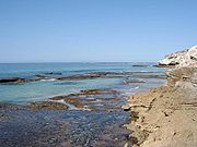
Cape Agulhas is a rocky headland in the Western Cape, South Africa. It is the geographic southern tip of Africa and the official dividing point between the Atlantic and Indian oceans...
, South Africa with the loss of 372 lives and only 6 survivors. She had been requisition
Requisition
A requisition is a request for something, especially a formal written request on a pre-printed form.An online requisition is an electronic document, which can be originated by the requester and then using the company workflow or hierarchy rules, can be submitted to the subsequent levels, until it...
ed as a troopship
Troopship
A troopship is a ship used to carry soldiers, either in peacetime or wartime...
and was underway from Ceylon to England on a journey to repatriate wounded soldiers from the Kandyan Wars.
Controversially, the ship did not have a marine chronometer
Marine chronometer
A marine chronometer is a clock that is precise and accurate enough to be used as a portable time standard; it can therefore be used to determine longitude by means of celestial navigation...
onboard, a comparatively new and expensive navigational instrument that would have enabled her to determine her longitude
History of longitude
The history of longitude is a record of the effort, by navigators and scientists over several centuries, to discover a means of determining longitude....
accurately. Instead, she was forced to navigate through the heavy storm and strong currents using older, less reliable navigational aids such as dead reckoning
Dead reckoning
In navigation, dead reckoning is the process of calculating one's current position by using a previously determined position, or fix, and advancing that position based upon known or estimated speeds over elapsed time, and course...
. Navigational difficulties and a lack of headway led to an incorrect assumption that Cape Agulhas
Cape Agulhas
Cape Agulhas is a rocky headland in the Western Cape, South Africa. It is the geographic southern tip of Africa and the official dividing point between the Atlantic and Indian oceans...
was Cape Point
Cape Point
Cape Point is a promontory at the southeast corner of the Cape Peninsula, which is a mountainous and scenic landform that runs north-south for about thirty kilometres at the extreme southwestern tip of the African continent in the Republic of South Africa. Table Mountain and the city of Cape Town...
. Consequently, the ship was wrecked when the captain headed north for St Helena with the incorrect belief the ship had already passed Cape Point
Cape Point
Cape Point is a promontory at the southeast corner of the Cape Peninsula, which is a mountainous and scenic landform that runs north-south for about thirty kilometres at the extreme southwestern tip of the African continent in the Republic of South Africa. Table Mountain and the city of Cape Town...
.
Overview
East Indiamen operated under charter or licence to the Honourable East India Company, which held a monopoly granted by Queen Elizabeth I of England for all English trade between the Cape of Good HopeCape of Good Hope
The Cape of Good Hope is a rocky headland on the Atlantic coast of the Cape Peninsula, South Africa.There is a misconception that the Cape of Good Hope is the southern tip of Africa, because it was once believed to be the dividing point between the Atlantic and Indian Oceans. In fact, the...
and Cape Horn
Cape Horn
Cape Horn is the southernmost headland of the Tierra del Fuego archipelago of southern Chile, and is located on the small Hornos Island...
. The Arniston was built at the Barnard yard at Deptford
Deptford
Deptford is a district of south London, England, located on the south bank of the River Thames. It is named after a ford of the River Ravensbourne, and from the mid 16th century to the late 19th was home to Deptford Dockyard, the first of the Royal Navy Dockyards.Deptford and the docks are...
on the Thames
River Thames
The River Thames flows through southern England. It is the longest river entirely in England and the second longest in the United Kingdom. While it is best known because its lower reaches flow through central London, the river flows alongside several other towns and cities, including Oxford,...
and launched in 1794.Mitchell 2007, tertiary sources. She was owned by Messrs Borradailes of London, and managed by John Wedderburn (1794 to 1808) then Robert Hudson (1809 to 1813).
The Arniston was heavily armed, with her fifty eight guns making her the equivalent of a Royal Navy
Royal Navy
The Royal Navy is the naval warfare service branch of the British Armed Forces. Founded in the 16th century, it is the oldest service branch and is known as the Senior Service...
fourth-rate
Fourth-rate
In the British Royal Navy, a fourth rate was, during the first half of the 18th century, a ship of the line mounting from 46 up to 60 guns. While the number of guns stayed subsequently in the same range up until 1817, after 1756 the ships of 50 guns and below were considered too weak to stand in...
ship of the line
Ship of the line
A ship of the line was a type of naval warship constructed from the 17th through the mid-19th century to take part in the naval tactic known as the line of battle, in which two columns of opposing warships would manoeuvre to bring the greatest weight of broadside guns to bear...
. A classification of "ship of the line" — a class of ship that later evolved into the battleship
Battleship
A battleship is a large armored warship with a main battery consisting of heavy caliber guns. Battleships were larger, better armed and armored than cruisers and destroyers. As the largest armed ships in a fleet, battleships were used to attain command of the sea and represented the apex of a...
— meant that a ship was powerful enough to stand in a line of battle
Line of battle
In naval warfare, the line of battle is a tactic in which the ships of the fleet form a line end to end. A primitive form had been used by the Portuguese under Vasco Da Gama in 1502 near Malabar against a Muslim fleet.,Maarten Tromp used it in the Action of 18 September 1639 while its first use in...
and explained why these ships of commerce were sometimes mistaken for men-o-war. The armament was necessary for the ship to protect herself and her valuable cargo from pirates and commerce raiders
Commerce raiding
Commerce raiding or guerre de course is a form of naval warfare used to destroy or disrupt the logistics of an enemy on the open sea by attacking its merchant shipping, rather than engaging the combatants themselves or enforcing a blockade against them.Commerce raiding was heavily criticised by...
of other nations during long voyages between Europe and the Far East
Far East
The Far East is an English term mostly describing East Asia and Southeast Asia, with South Asia sometimes also included for economic and cultural reasons.The term came into use in European geopolitical discourse in the 19th century,...
.
She had three decks, a length of 176 feet (53.6 m), a keel
Keel
In boats and ships, keel can refer to either of two parts: a structural element, or a hydrodynamic element. These parts overlap. As the laying down of the keel is the initial step in construction of a ship, in British and American shipbuilding traditions the construction is dated from this event...
of 143 feet (43.6 m) and a breadth of 43 feet (13.1 m). She measured 1468 tons, so like other East Indiamen, was slow and unmanoeuvrable, but able to carry a large quantity of cargo.
Voyages (1794–1812)
The Arniston sailed from Great BritainGreat Britain
Great Britain or Britain is an island situated to the northwest of Continental Europe. It is the ninth largest island in the world, and the largest European island, as well as the largest of the British Isles...
to the Far East
Far East
The Far East is an English term mostly describing East Asia and Southeast Asia, with South Asia sometimes also included for economic and cultural reasons.The term came into use in European geopolitical discourse in the 19th century,...
eight times before her last voyage.BL 1812, primary sources. On one of her homeward journeys from China, she struck an uncharted rock at 5°46′8"S 105°16′43"E, near the island of Pulo Goondy (modern day Pulau Legundi), located just south of Sumatra
Sumatra
Sumatra is an island in western Indonesia, westernmost of the Sunda Islands. It is the largest island entirely in Indonesia , and the sixth largest island in the world at 473,481 km2 with a population of 50,365,538...
. She did not suffer any ill effects as a result of this incident however, which is mentioned in journals of the time only for its noteworthyness as a navigation hazard to other shipping.
A more significant event occurred during her third voyage to the Far East however. On 27 June 1800, the Arniston had just anchored at Benkulen when the 26-gun French privateer
Privateer
A privateer is a private person or ship authorized by a government by letters of marque to attack foreign shipping during wartime. Privateering was a way of mobilizing armed ships and sailors without having to spend public money or commit naval officers...
Confiance attacked her. The Arniston cut her anchor and gave chase, firing several broadside
Broadside
A broadside is the side of a ship; the battery of cannon on one side of a warship; or their simultaneous fire in naval warfare.-Age of Sail:...
s into the other ship. The faster French ship was able to make an escape however.Lindsay 1874, primary sources. On 9 October 1800, another East Indiaman, the Kent, would be less fortunate, being captured after a two hour battle with the same raider.
Apart from these two incidents, the Arniston's first eight voyages were otherwise uneventful.
(1794/1795) St Helena, Madras, and China
Captain Campbell Marjoribanks: Portsmouth
Portsmouth
Portsmouth is the second largest city in the ceremonial county of Hampshire on the south coast of England. Portsmouth is notable for being the United Kingdom's only island city; it is located mainly on Portsea Island...
3 April 1795 – 14 April Tenerife
Tenerife
Tenerife is the largest and most populous island of the seven Canary Islands, it is also the most populated island of Spain, with a land area of 2,034.38 km² and 906,854 inhabitants, 43% of the total population of the Canary Islands. About five million tourists visit Tenerife each year, the...
– 2 June St Helena 2 July – 9 August Cape – 27 September Madras – 14 November Penang
Penang
Penang is a state in Malaysia and the name of its constituent island, located on the northwest coast of Peninsular Malaysia by the Strait of Malacca. It is bordered by Kedah in the north and east, and Perak in the south. Penang is the second smallest Malaysian state in area after Perlis, and the...
– 3 December Malacca
Malacca
Malacca , dubbed The Historic State or Negeri Bersejarah among locals) is the third smallest Malaysian state, after Perlis and Penang. It is located in the southern region of the Malay Peninsula, on the Straits of Malacca. It borders Negeri Sembilan to the north and the state of Johor to the south...
– 11 March 1796 Whampoa
Huangpu District, Guangzhou
Huangpu District is one of the ten districts in Guangzhou, Guangdong province, People's Republic of China.-History:...
– 23 April Second Bar – 29 June Macau
Macau
Macau , also spelled Macao , is, along with Hong Kong, one of the two special administrative regions of the People's Republic of China...
– 20 November St Helena – 1 March 1797 Deptford
Deptford
Deptford is a district of south London, England, located on the south bank of the River Thames. It is named after a ford of the River Ravensbourne, and from the mid 16th century to the late 19th was home to Deptford Dockyard, the first of the Royal Navy Dockyards.Deptford and the docks are...
(1796/1797) China
Captain William Macnamara: Portsmouth
Portsmouth
Portsmouth is the second largest city in the ceremonial county of Hampshire on the south coast of England. Portsmouth is notable for being the United Kingdom's only island city; it is located mainly on Portsea Island...
5 June 1797 – 29 August Cape
Cape of Good Hope
The Cape of Good Hope is a rocky headland on the Atlantic coast of the Cape Peninsula, South Africa.There is a misconception that the Cape of Good Hope is the southern tip of Africa, because it was once believed to be the dividing point between the Atlantic and Indian Oceans. In fact, the...
– 9 December Whampoa
Huangpu District, Guangzhou
Huangpu District is one of the ten districts in Guangzhou, Guangdong province, People's Republic of China.-History:...
– 14 February 1798 Second Bar – 26 March Macau
Macau
Macau , also spelled Macao , is, along with Hong Kong, one of the two special administrative regions of the People's Republic of China...
– 5 August St Helena – 23 October Long Reach
(1799/1800) St Helena, Benkulen, and China
Captain Campbell Marjoribanks: Portsmouth
Portsmouth
Portsmouth is the second largest city in the ceremonial county of Hampshire on the south coast of England. Portsmouth is notable for being the United Kingdom's only island city; it is located mainly on Portsea Island...
7 January 1800 – 4 April St Helena – 27 June Benkulen – 29 July Penang – 27 August Malacca
Malacca
Malacca , dubbed The Historic State or Negeri Bersejarah among locals) is the third smallest Malaysian state, after Perlis and Penang. It is located in the southern region of the Malay Peninsula, on the Straits of Malacca. It borders Negeri Sembilan to the north and the state of Johor to the south...
– 21 September Whampoa
Huangpu District, Guangzhou
Huangpu District is one of the ten districts in Guangzhou, Guangdong province, People's Republic of China.-History:...
– 29 November Second Bar
Pearl River (China)
The Pearl River or less commonly, the "Guangdong River" or "Canton River" etc., , is an extensive river system in southern China. The name Pearl River is usually used as a catchment term to refer to the watersheds of the Xi Jiang , the Bei Jiang , and the Dong Jiang...
– 18 January 1801 Macau
Macau
Macau , also spelled Macao , is, along with Hong Kong, one of the two special administrative regions of the People's Republic of China...
– 15 April St Helena – 17 June Long Reach
(1801/1802) St Helena, Benkulen, and China
Captain Campbell Marjoribanks: Downs 31 December 1801 – 9 March 1802 St Helena – 10 June Benkulen – 12 July Penang – 31 August Whampoa – 24 October Second Bar – 11 February 1803 – St Helena – 26 April Long Reach
(1803/1804) China
Captain James Jameson: Portsmouth
Portsmouth
Portsmouth is the second largest city in the ceremonial county of Hampshire on the south coast of England. Portsmouth is notable for being the United Kingdom's only island city; it is located mainly on Portsea Island...
9 June 1804 – 17 August Rio de Janeiro
Rio de Janeiro
Rio de Janeiro , commonly referred to simply as Rio, is the capital city of the State of Rio de Janeiro, the second largest city of Brazil, and the third largest metropolitan area and agglomeration in South America, boasting approximately 6.3 million people within the city proper, making it the 6th...
– 14 January 1805 Whampoa
Huangpu District, Guangzhou
Huangpu District is one of the ten districts in Guangzhou, Guangdong province, People's Republic of China.-History:...
– 14 February Second Bar
Pearl River (China)
The Pearl River or less commonly, the "Guangdong River" or "Canton River" etc., , is an extensive river system in southern China. The name Pearl River is usually used as a catchment term to refer to the watersheds of the Xi Jiang , the Bei Jiang , and the Dong Jiang...
– 21 March Malacca
Malacca
Malacca , dubbed The Historic State or Negeri Bersejarah among locals) is the third smallest Malaysian state, after Perlis and Penang. It is located in the southern region of the Malay Peninsula, on the Straits of Malacca. It borders Negeri Sembilan to the north and the state of Johor to the south...
– 30 June St Helena – 15 September Long Reach. This journey included a passage through the Bass Strait
Bass Strait
Bass Strait is a sea strait separating Tasmania from the south of the Australian mainland, specifically the state of Victoria.-Extent:The International Hydrographic Organization defines the limits of the Bass Strait as follows:...
in order to improve an earlier nautical chart
Nautical chart
A nautical chart is a graphic representation of a maritime area and adjacent coastal regions. Depending on the scale of the chart, it may show depths of water and heights of land , natural features of the seabed, details of the coastline, navigational hazards, locations of natural and man-made aids...
of the route.
(1805/1806) China
Captain Peter Wedderburn: Portsmouth
Portsmouth
Portsmouth is the second largest city in the ceremonial county of Hampshire on the south coast of England. Portsmouth is notable for being the United Kingdom's only island city; it is located mainly on Portsea Island...
14 May 1806 – 7 August Cape
Cape of Good Hope
The Cape of Good Hope is a rocky headland on the Atlantic coast of the Cape Peninsula, South Africa.There is a misconception that the Cape of Good Hope is the southern tip of Africa, because it was once believed to be the dividing point between the Atlantic and Indian Oceans. In fact, the...
– 10 October Penang
Penang
Penang is a state in Malaysia and the name of its constituent island, located on the northwest coast of Peninsular Malaysia by the Strait of Malacca. It is bordered by Kedah in the north and east, and Perak in the south. Penang is the second smallest Malaysian state in area after Perlis, and the...
– 21 January 1807 Whampoa
Huangpu District, Guangzhou
Huangpu District is one of the ten districts in Guangzhou, Guangdong province, People's Republic of China.-History:...
– 4 May off Lintin Island– 1 July Penang
Penang
Penang is a state in Malaysia and the name of its constituent island, located on the northwest coast of Peninsular Malaysia by the Strait of Malacca. It is bordered by Kedah in the north and east, and Perak in the south. Penang is the second smallest Malaysian state in area after Perlis, and the...
– 17 July Acheh – 19 September Cape
Cape of Good Hope
The Cape of Good Hope is a rocky headland on the Atlantic coast of the Cape Peninsula, South Africa.There is a misconception that the Cape of Good Hope is the southern tip of Africa, because it was once believed to be the dividing point between the Atlantic and Indian Oceans. In fact, the...
– 13 October St Helena – 6 January 1808 Lower Hope
(1809/1810) Bombay and China
Captain Samuel Landon: Portsmouth
Portsmouth
Portsmouth is the second largest city in the ceremonial county of Hampshire on the south coast of England. Portsmouth is notable for being the United Kingdom's only island city; it is located mainly on Portsea Island...
21 January 1810 – 9 April Cape – 26 May Bombay – 1 September Penang
Penang
Penang is a state in Malaysia and the name of its constituent island, located on the northwest coast of Peninsular Malaysia by the Strait of Malacca. It is bordered by Kedah in the north and east, and Perak in the south. Penang is the second smallest Malaysian state in area after Perlis, and the...
– 12 October Whampoa
Huangpu District, Guangzhou
Huangpu District is one of the ten districts in Guangzhou, Guangdong province, People's Republic of China.-History:...
– 29 December Second Bar
Pearl River (China)
The Pearl River or less commonly, the "Guangdong River" or "Canton River" etc., , is an extensive river system in southern China. The name Pearl River is usually used as a catchment term to refer to the watersheds of the Xi Jiang , the Bei Jiang , and the Dong Jiang...
– 28 May 1811 St Helena – 13 August Long Reach
(1811/1812) Bombay and China
Captain Walter Campbell: Torbay
Torbay
Torbay is an east-facing bay and natural harbour, at the western most end of Lyme Bay in the south-west of England, situated roughly midway between the cities of Exeter and Plymouth. Part of the ceremonial county of Devon, Torbay was made a unitary authority on 1 April 1998...
4 January 1812 – 5 April Johanna – 7 May Bombay – 11 September Whampoa
Huangpu District, Guangzhou
Huangpu District is one of the ten districts in Guangzhou, Guangdong province, People's Republic of China.-History:...
– 4 January 1813 Macau
Macau
Macau , also spelled Macao , is, along with Hong Kong, one of the two special administrative regions of the People's Republic of China...
– 27 March St Helena – 7 June Long Reach
Wreck (1815)
The Arniston was requisitioned by the Royal NavyRoyal Navy
The Royal Navy is the naval warfare service branch of the British Armed Forces. Founded in the 16th century, it is the oldest service branch and is known as the Senior Service...
in 1814 as a troop transport
Troopship
A troopship is a ship used to carry soldiers, either in peacetime or wartime...
to repatriate soldiers of the 73rd Regiment, who were wounded in the Kandyan Wars in Ceylon, to England. Critically, the ship did not have a chronometer
Marine chronometer
A marine chronometer is a clock that is precise and accurate enough to be used as a portable time standard; it can therefore be used to determine longitude by means of celestial navigation...
for this voyage, a comparatively new and expensive navigational instrument at the time. Captain George Simpson could not afford the 60-100 guinea
Guinea (British coin)
The guinea is a coin that was minted in the Kingdom of England and later in the Kingdom of Great Britain and the United Kingdom between 1663 and 1813...
s for one,Hall 1820, primary sources. and his bosses were also unwilling to purchase one, even threatening to replace him with another captain if he refused to set sail without one.Hall 1833, primary sources.
The Arniston sailed from Port de Galle
Galle
Galle is a city situated on the southwestern tip of Sri Lanka, 119 km from Colombo. Galle is the capital city of Southern Province of Sri Lanka and it lies in Galle District....
on 4 April 1815 in a convoy of six other East Indiamen
East Indiamen
An East Indiaman was a ship operating under charter or license to any of the East India Companies of the major European trading powers of the 17th through the 19th centuries...
, under the escort of HMS Africaine
French ship L'Africaine
The Africaine was one of two 40-gun Preneuse class frigate of the French Navy built to a design by Raymond-Antoine Haran. She carried 28 18-pounder and 12 8-pounder guns. The British captured her in 1801, only to have the French recapture her in 1810...
and HMS Victor. Among her 378 passengers were many invalid soldiers and sailors, plus 14 women and 25 children.
During the passage from Ceylon, at one o'clock every day, the ships signalled each other their longitude
History of longitude
The history of longitude is a record of the effort, by navigators and scientists over several centuries, to discover a means of determining longitude....
that they calculated using their chronometers. In this way, the ships were able to compare their respective instruments, and the master of the Arniston was enable to learn his longitude too, as long as he remained in the convoy.
On 26 May, while rounding the southern tip of Africa, the Arniston was separated from the convoy in bad weather after her sails were damaged. Without accurate daily longitudinal information from the other ships, the Arniston had to rely instead on older, less accurate navigation methods. Navigation via dead reckoning
Dead reckoning
In navigation, dead reckoning is the process of calculating one's current position by using a previously determined position, or fix, and advancing that position based upon known or estimated speeds over elapsed time, and course...
proved particularly difficult as there were strong ocean currents combined with inclement weather that prevented a fix
Fix (position)
In position fixing navigation, a position fix or simply a fix is a position derived from measuring external reference points.The term is generally used with manual or visual techniques such as the use of intersecting visual or radio position lines rather than the use of more automated and accurate...
being obtained for several days via celestial navigation
Celestial navigation
Celestial navigation, also known as astronavigation, is a position fixing technique that has evolved over several thousand years to help sailors cross oceans without having to rely on estimated calculations, or dead reckoning, to know their position...
.
Cape of Good Hope
The Cape of Good Hope is a rocky headland on the Atlantic coast of the Cape Peninsula, South Africa.There is a misconception that the Cape of Good Hope is the southern tip of Africa, because it was once believed to be the dividing point between the Atlantic and Indian Oceans. In fact, the...
. The ship sailed west until 4:30pm on 29 May, then turned north to run for St Helena. However the land sighted had in fact been Cape Agulhas
Cape Agulhas
Cape Agulhas is a rocky headland in the Western Cape, South Africa. It is the geographic southern tip of Africa and the official dividing point between the Atlantic and Indian oceans...
(then known as "Cape L'Agullas") and the ship had also not made good headway against the current since this sighting. Compounding these navigational errors, the master had not taken any depth soundings
Sounding line
A sounding line or lead line is a length of thin rope with a plummet, generally of lead, at its end. Regardless of the actual composition of the plummet, it is still called a "lead."...
(which would have confirmed his location over the Agulhas Bank
Agulhas Bank
The Agulhas Bank is a broad, shallow part of the southern African continental shelf which extends south of Cape Agulhas before falling away steeply away to the abyssal plain....
), before heading north. Consequently, instead of being 100 miles (160.9 km) West of the Cape of Good Hope
Cape of Good Hope
The Cape of Good Hope is a rocky headland on the Atlantic coast of the Cape Peninsula, South Africa.There is a misconception that the Cape of Good Hope is the southern tip of Africa, because it was once believed to be the dividing point between the Atlantic and Indian Oceans. In fact, the...
as presumed, the ship was closing on the reef at Waenhuiskrans near Cape Agulhas. The anchor
Anchor
An anchor is a device, normally made of metal, that is used to connect a vessel to the bed of a body of water to prevent the vessel from drifting due to wind or current. The word derives from Latin ancora, which itself comes from the Greek ἄγκυρα .Anchors can either be temporary or permanent...
s were unable to hold the heavy ship in the storm, so on 30 May near 4pm, Lieutenant Brice advised Captain Simpson to ground the ship in order to save the lives of those aboard. Eight minutes later, at about 8pm, the ship struck rocks half a mile offshore and heeled into the wind. The guns on the opposite side were cut away in a failed attempt to level the ship, which soon started to break up in the waves.AJ 1816, primary sources.
Only 6 men of the 378 people on board survived, after reaching the shore only with great difficulty through the high surf
Ocean surface wave
In fluid dynamics, wind waves or, more precisely, wind-generated waves are surface waves that occur on the free surface of oceans, seas, lakes, rivers, and canals or even on small puddles and ponds. They usually result from the wind blowing over a vast enough stretch of fluid surface. Waves in the...
. The following morning, the sternpost
Sternpost
A sternpost is the upright structural member or post at the stern of a ship or a boat, to which are attached the transoms and the rearmost left corner part of the stern...
was the only part of the vessel still visible. The ship and her passengers had been lost for the price of a chronometer, or as an officer from the same convoy later wrote:
Aftermath
The six survivors buried the bodies found on the beach, then travelled East along the beach, expecting to reach Cape TownCape Town
Cape Town is the second-most populous city in South Africa, and the provincial capital and primate city of the Western Cape. As the seat of the National Parliament, it is also the legislative capital of the country. It forms part of the City of Cape Town metropolitan municipality...
. However after four and a half days, they realised their error and returned to the site of the wreck. Here they subsisted off a cask of oatmeal
Oatmeal
Oatmeal is ground oat groats , or a porridge made from oats . Oatmeal can also be ground oat, steel-cut oats, crushed oats, or rolled oats....
, while trying to effect repairs to the ship's pinnace
Pinnace (ship's boat)
As a ship's boat the pinnace is a light boat, propelled by sails or oars, formerly used as a "tender" for guiding merchant and war vessels. In modern parlance, pinnace has come to mean a boat associated with some kind of larger vessel, that doesn't fit under the launch or lifeboat definitions...
, which had been washed ashore. They were discovered six days later on 14 June by a farmer's son who was out hunting.
- Among the victims were: Captain George Simpson, Lieutenant Brice, Lord and Lady MolesworthViscount MolesworthViscount Molesworth, of Swords in the County of Dublin, is a title in the Peerage of Ireland. It was created in 1716 for Robert Molesworth. He was made Baron Philipstown, of Swords in the County of Dublin, at the same time, also in the Peerage of Ireland...
. - The six survivors were: Dr. Gunter (boatswainBoatswainA boatswain , bo's'n, bos'n, or bosun is an unlicensed member of the deck department of a merchant ship. The boatswain supervises the other unlicensed members of the ship's deck department, and typically is not a watchstander, except on vessels with small crews...
), John Barrett (carpenter), Charles Stewart Scott (carpenter's mate), William Grung (second class), Gibbs (third class), Robinson (fourth class).
A memorial, a replica of which can be seen today, was erected on the beach by the wife of Colonel Giels, whose four children were lost in the tragedy on their homeward journey, having visited him in Ceylon. The memorial bears the following inscription:
Over time, the seaside village of Waenhuiskrans has become so associated with the wreck, that it too is now known as Arniston. The nearby town of Bredasdorp
Bredasdorp
Bredasdorp is a town in the Southern Overberg region of the Western Cape, South Africa, and the main economic and service hub of that region. It lies on the northern edge of the Agulhas Plain, about south-east of Cape Town and north of Cape Agulhas, the southernmost tip of Africa.-History:The...
has a museum dedicated to the wreck. The wreck had a direct influence on the decision to build a lighthouse at Cape Agulhas
Cape Agulhas
Cape Agulhas is a rocky headland in the Western Cape, South Africa. It is the geographic southern tip of Africa and the official dividing point between the Atlantic and Indian oceans...
in 1847-1848.Proposals for a Lighthouse at L'Agulhas, secondary sources.
Thirty seven years later, the 73rd Regiment of Foot suffered hundreds of casualties on this coast once again when HMS Birkenhead
HMS Birkenhead (1845)
HMS Birkenhead, also referred to as HM Troopship Birkenhead or steam frigate Birkenhead, was one of the first iron-hulled ships built for the Royal Navy...
was wrecked only 50 miles (80.5 km) away at Gansbaai.
Archaeological excavation
The wreck, which lies in about 6 metres (19.7 ft) of water, was surveyed by an archaeological team from the University of Cape TownUniversity of Cape Town
The University of Cape Town is a public research university located in Cape Town in the Western Cape province of South Africa. UCT was founded in 1829 as the South African College, and is the oldest university in South Africa and the second oldest extant university in Africa.-History:The roots of...
(UCT) in 1982. The National Monuments Council issued a permit to UCT student Jim Jobling to conduct an underwater survey of the site, as well as a limited excavation. A number of artefacts were recovered, which were donated to the Bredasdorp Shipwreck Museum.
External links
- The Arniston story at Submerged.co.uk – Model of the Arniston, photographs of the memorial and beach.