

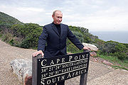
Cape Point
Encyclopedia
Promontory
Promontory may refer to:*Promontory, a prominent mass of land which overlooks lower lying land or a body of water*Promontory, Utah, the location where the United States first Transcontinental Railroad was completed...
at the southeast corner of the Cape Peninsula
Cape Peninsula
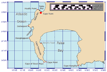
The Cape Peninsula is a generally rocky peninsula that juts out for 75 km into the Atlantic Ocean at the south-western extremity of the African continent. At the southern end of the peninsula are Cape Point and the Cape of Good Hope...
, which is a mountainous and scenic landform that runs north-south for about thirty kilometres at the extreme southwestern tip of the Africa
Africa
Africa is the world's second largest and second most populous continent, after Asia. At about 30.2 million km² including adjacent islands, it covers 6% of the Earth's total surface area and 20.4% of the total land area...
n continent in the Republic of South Africa
South Africa
The Republic of South Africa is a country in southern Africa. Located at the southern tip of Africa, it is divided into nine provinces, with of coastline on the Atlantic and Indian oceans...
. Table Mountain
Table Mountain
Table Mountain is a flat-topped mountain forming a prominent landmark overlooking the city of Cape Town in South Africa, and is featured in the flag of Cape Town and other local government insignia. It is a significant tourist attraction, with many visitors using the cableway or hiking to the top...
and the city of Cape Town
Cape Town
Cape Town is the second-most populous city in South Africa, and the provincial capital and primate city of the Western Cape. As the seat of the National Parliament, it is also the legislative capital of the country. It forms part of the City of Cape Town metropolitan municipality...
are close to the northern extremity of the same peninsula. The cape is located at 34°21′26"S 18°29′51"E, about 2.3 kilometres (1.4 mi) east and a little north of the Cape of Good Hope
Cape of Good Hope
The Cape of Good Hope is a rocky headland on the Atlantic coast of the Cape Peninsula, South Africa.There is a misconception that the Cape of Good Hope is the southern tip of Africa, because it was once believed to be the dividing point between the Atlantic and Indian Oceans. In fact, the...
on the southwest corner. Although these two rocky and beautiful capes are very well known, neither cape is actually the southernmost point in Africa; that is Cape Agulhas
Cape Agulhas
Cape Agulhas is a rocky headland in the Western Cape, South Africa. It is the geographic southern tip of Africa and the official dividing point between the Atlantic and Indian oceans...
, approximately 150 kilometres (90 mi) to the east-southeast.
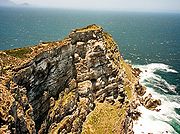
Peaks
Cape of Good Hope
The Cape of Good Hope is a rocky headland on the Atlantic coast of the Cape Peninsula, South Africa.There is a misconception that the Cape of Good Hope is the southern tip of Africa, because it was once believed to be the dividing point between the Atlantic and Indian Oceans. In fact, the...
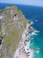
. The rugged sandstone (Table Mountain sandstone) ridge that rises from Cape Point at sea level develops into two peaks. There is a major peak that dominates the skyline locally but there is also a smaller peak about 100 m further south. The higher peak has the old lighthouse
Lighthouse
A lighthouse is a tower, building, or other type of structure designed to emit light from a system of lamps and lenses or, in older times, from a fire, and used as an aid to navigation for maritime pilots at sea or on inland waterways....
on the top. The Flying Dutchman Funicular
Flying Dutchman Funicular
The Flying Dutchman Funicular, also known as the Cape Point Funicular, is a funicular railway located at Cape Point, near the Cape of Good Hope in the Western Cape province of South Africa...
runs from a car park to the north up to slightly below the level of the old lighthouse and a short flight of steps leads to a viewing platform at the base of the lighthouse. From the end of the railway a second path leads to the lower peak.
Lighthouse
The new lighthouse is at a lower elevation (closer to sea levelSea level
Mean sea level is a measure of the average height of the ocean's surface ; used as a standard in reckoning land elevation...
), for two reasons: the old lighthouse could be seen 'too early' by ships rounding the point towards the east, causing them to approach too closely. Secondly, foggy conditions often prevail at the higher levels, making the older lighthouse invisible to shipping. On 18 April 1911, the Portuguese liner Lusitania was wrecked just south of Cape Point at 34°23′22"S 18°29′23"E on Bellows Rock for precisely this reason, prompting the relocation of the lighthouse.
The new location cannot be seen from the West until ships are at a safe distance to the South. The light of the new Cape Point lighthouse is the most powerful on the South African coast, with a range of 63 kilometres (39 mi) and an intensity of 10 megacandelas in each flash.
Cape Point is situated within the Table Mountain National Park
Table Mountain National Park
Table Mountain National Park, previously known as the Cape Peninsula National Park, is a national park in Cape Town, South Africa, proclaimed on May 29, 1998, for the purpose of protecting the natural environment of the Table Mountain Chain, and in particular the rare fynbos vegetation...
, within a section of the Park referred to as Cape of Good Hope. This section covers the whole of the southern tip of the Cape Peninsula and which takes in perhaps 20% of its total area. The Cape of Good Hope section of the park is generally wild, unspoiled and undeveloped and is an important haven for seabirds. The vegetation at Cape Point consists primarily of Peninsula Sandstone Fynbos
Peninsula Sandstone Fynbos
Peninsula Sandstone Fynbos is a unique and endangered vegetation type that is endemic to the Cape Peninsula in Cape Town. This type of Mountain Fynbos occurs on very poor, acidic soils but is incredibly rich in biodiversity with an enormous number of plant species – many of which occur nowhere else...
.
Benguela Current
The Benguela Current is the broad, northward flowing ocean current that forms the eastern portion of the South Atlantic Ocean gyre. The current extends from roughly Cape Point in the south, to the position of the Angola-Benguela Front in the north, at around 16°S. The current is driven by the...
of the Atlantic Ocean and the warm Agulhas Current
Agulhas Current
The Agulhas Current is the Western Boundary Current of the southwest Indian Ocean. It flows down the east coast of Africa from 27°S to 40°S. It is narrow, swift and strong...
of the Indian ocean collide. In fact, the meeting point fluctuates along the southern and southwestern Cape coast, usually occurring between Cape Agulhas
Cape Agulhas
Cape Agulhas is a rocky headland in the Western Cape, South Africa. It is the geographic southern tip of Africa and the official dividing point between the Atlantic and Indian oceans...
and Cape Point. The two intermingling currents help to create the micro-climate of Cape Town
Cape Town
Cape Town is the second-most populous city in South Africa, and the provincial capital and primate city of the Western Cape. As the seat of the National Parliament, it is also the legislative capital of the country. It forms part of the City of Cape Town metropolitan municipality...
and its environs. Contrary to popular mythology, the meeting point of the currents produces no obvious visual effect; there is no "line in the ocean" where the sea changes colour or looks different in some way. There are, however, strong and dangerous swells, tides and localized currents around the point and in adjacent waters. These troubled seas have witnessed countless maritime disasters in the centuries since ships first sailed here.
Fishing is good along the coast but the unpredictable swells make angling from the rocks very dangerous. Over the years scores of fishermen have been swept to their deaths from the rocky platforms by freak waves. False Bay
False Bay
False Bay is a body of water defined by Cape Hangklip and the Cape Peninsula in the extreme South-West of South Africa.- Description and location :...
, which opens to the east and north of Cape Point, is the location of the well-known naval port of Simon's Town
Simon's Town
Simon's Town , sometimes spelled Simonstown; is a town in South Africa, near Cape Town which is home to the South African Navy. It is located on the shores of False Bay, on the eastern side of the Cape Peninsula. For more than two centuries it has been an important naval base and harbour...
. The bay is also famous - or infamous - for its great white sharks, which hunt the Cape Fur Seal
Cape Fur Seal
The brown fur seal , also known as the Cape fur seal, South African fur seal and the Australian fur seal is a species of fur seal.-Description:...
s that live in the area.
Climate research
Cape Point is the site of one of the Global Atmosphere WatchGlobal Atmosphere Watch
The Global Atmosphere Watch is a worldwide system established by the World Meteorological Organization a United Nations agency to monitor trends in the Earth's atmosphere...
's atmospheric research stations. In the early years of the 20th century icebergs from Antarctica were occasionally sighted from Cape Point. There have been no authentic recent sightings of ice, which some climatologists and experts have attributed to global warming
Global warming
Global warming refers to the rising average temperature of Earth's atmosphere and oceans and its projected continuation. In the last 100 years, Earth's average surface temperature increased by about with about two thirds of the increase occurring over just the last three decades...
.