

William Roy
Encyclopedia
Major-General William Roy FRS (4 May 1726 – 1 July 1790) was a Scottish
military engineer
, surveyor, and antiquarian
. He was an innovator who applied new scientific discoveries and newly emerging technologies to the accurate geodetic
mapping of Great Britain
.
It was Roy's advocacy and leadership that led to the creation of the Ordnance Survey
in 1791, the year after his death. His technical work in the establishment of a surveying baseline
won him the Copley Medal
in 1785. His maps and drawings of Roman
archaeological sites in Scotland
were the first accurate and systematic study of the subject, and have not been improved upon even today. Roy was a Fellow of the Royal Society
and a member of the Society of Antiquaries of London
.
Parish in South Lanarkshire
in 1726, and was educated in the parish school and Lanark Grammar School
. There is no record of his further education, but circumstances strongly suggest that he obtained one. He was a respected land surveyor employed by the Callander family at their Craigforth estate near Stirling
prior to his work for the military, and his demonstrated knowledge of general science, geodesy
, chemistry
, and astronomy
imply that he was once an apt pupil within a formal system of education.
Roy's father had been a steward or factor (i.e., a representative of a landowner in Scotland) in the service of the Hamiltons of Hallcraig, as well as an elder of the Kirk
. His grandfather had held a similar position as factor, and his uncle acted in that capacity for the Lockharts of Lee
. His younger brother James had held the bursary in the Grammar School and College of Glasgow, took a Master of Arts after studies in the Languages and Philosophy, was licensed by the Presbytery of Glasgow, and held several other notable positions before his untimely death in 1767, at the age of 37.
Roy maintained his connections to his birthplace and the people living there. A servant for the Lockharts of Lee recalled his visits there over time, as his national reputation grew. She noted that at first he would dine in the servants hall, in later years he would dine with the family, and later on still he would be seated at the right hand of the Laird
.
to facilitate the subjugation of the clan
s following the Jacobite
rising of 1745
. In response, King George II
commissioned a military survey of the Highlands, and Watson was placed in charge under the command of the Duke of Cumberland. Among his assistants were William Roy, Paul Sandby
, and John Manson. The labours of Watson and Roy, and of Roy in particular, resulted in The Duke of Cumberland's Map, now in the British Library. The map reflects Roy's lifelong interest in ancient Scottish history by showing the locations of ancient Roman
remains, primarily military camps, wherever he encountered them.
Roy was first mentioned in connection with this effort in a 1749 letter, by which time he was Assistant to the Deputy Quartermaster-General, but without a military commission. He would continue to work on the survey until 1755, and was then given a military commission and the title of Practitioner-Engineer. He was promoted steadily, reflecting acknowledgement of his considerable technical talents.
Roy's technical abilities and willingness to innovate brought him to the favourable attention of Duke Ferdinand of Brunswick
, the Commander-in-Chief of the Allied army at the Battle of Minden
in 1759. Preparatory to the battle, the various military engineers made drawings of each step of the coming battle, with each step drawn on a different sheet of paper. The commander could then study the course of the battle before it occurred, going from one sheet to the next. Lieutenant Roy, however, made his drawings on a single sheet with coordinated and accurate overlays, so that the commander could more easily study the course of the battle by examining a single sheet of paper. The commander's comprehension was greatly facilitated, and Roy's methodology was soon adopted as an advancement in military science. Roy was promoted to captain in the Corps of Highlanders a scant three weeks after the battle.
The next year he became a Deputy Quartermaster-General and major of foot, and was promoted to lieutenant-colonel in 1762. In 1765 he appears as a Deputy Quartermaster-General, Surveyor-General of Coasts, and Engineer-Director of military surveys in Great Britain, and in that capacity he visited Ireland
in 1766 and Gibraltar
in 1768. He became a Fellow of the Royal Society
in 1767.
 Roy was promoted to colonel in 1777, and to major-general in 1781. He was in charge of the departments of the Quartermaster-General and Chief Engineer in 1782, and in 1783 became the Director of Royal Engineers. In 1783-84 he conducted observations to determine the relative positions of the French
and English
royal observatories. In 1784 he measured a base-line for that purpose between Hampton and Heathrow (hamlet), the germ of all subsequent surveys of the United Kingdom, for which in 1785 the Royal Society
awarded him the Copley medal
. Roy's measurements (not fully utilised until 1787, when the Paris
and Greenwich
observatories were properly connected) form the basis of the topographical survey of Middlesex
, Surrey
, Kent
and Sussex
. These surveys were made for the most part using the new Ramsden theodolite
which Roy had commissioned from Jesse Ramsden
, and were the start of the Principal Triangulation of Great Britain
.
He was finishing an account of this work for the Philosophical Transactions of the Royal Society
when he died.
Roy's use of scientific advancements and accurate mathematical formulas paved the way for modern geodesic surveying. His tenure and his work are the dividing line between older, approximate mappings and newer, highly accurate ones in Britain. He is cited repeatedly in early nineteenth century mathematics textbooks for his use of spherical trigonometry
in surveying. Early twentieth century technical books on modern surveying and geodesy include Roy's work as the historical starting point for the modern profession.
 Antiquarian
Roy's maps and his drawings of the relics of the Roman presence in Scotland were immediately seen as credible and valuable. For sites where the Roman remains were later destroyed by human development, his drawings are the only reliable record of their existence.
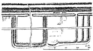
Roy was the first to systematically map the Antonine Wall and provide accurate and detailed drawings of its remains, an effort undertaken in 1764.
Historical work
His only historical work, Military Antiquities of the Romans in Britain, has a mixed reputation. His drawings and maps are held in the highest regard as still-valuable research sources. However, his efforts in the scholarly discussion of history are widely held to be without value, largely through no fault of his own. This was due to his belief that the spurious fraud De Situ Britanniae
was a genuine work, a view shared by virtually all of his contemporaries. Roy consequently adjusted his perspective to be consistent with the history as told in the fraud, causing his own conclusions to be without a valid foundation. Much of Roy's research was devoted to the attempt to follow fictitious journeys throughout Scotland that were described in De Situ Britanniae.
That Roy's considerable talents were partially wasted is a tragedy. He was a Scot with a lifelong interest in ancient Scottish history, and his technical ability and scientific knowledge made him uniquely qualified to provide information in an area of history where knowledge and understanding are minimal. That loss for Scottish history has been bemoaned by Scottish historians. In his introduction to Celtic Scotland, Skene
deprecates those historical works based on De Situ, including Roy's, but adds for him alone the comment that " ... perhaps more to be regretted, the valuable work of General Roy ..."
Minor biographical note
While Roy was a famous and notable person by the time of his death, some of the minor details of his military career have been susceptible to error in later articles about him, usually in a way that enhances Roy's actual status as a young, non-military assistant and surveyor. Among these, a 1793 obituary says he held the rank of Colonel of Artillery in 1746, whereas he was then a 20-year-old surveyor with no military commission, and who was never connected with the artillery. An 1885 book about Western Scotland with a chapter on Roy's life has him a Colonel in the British Army who was trusted with the work of mapping the Highlands
in 1747 by his commanding general. Roy deserves much of the technical credit for the map that resulted, but he was actually a non-military assistant to a Lieutenant-Colonel who was a Deputy Quartermaster-General. An 1874 book on the history of Carluke Parish and its people has Roy himself the Deputy Quartermaster-General.
The written history of the Royal Engineers makes a minor contribution to the list of errors, stating in passing that Roy was the nephew of his immediate supervisor in 1747, and was given the rank of Lieutenant. Roy was not related to David Watson, nor was he in the military at that time. The author has confused him with David Dundas
, who was the son of Watson's sister, and who joined his uncle in 1752.
In the British Museum
Maps and Plans drawn between 1752 and 1766
Publications
Scotland
Scotland is a country that is part of the United Kingdom. Occupying the northern third of the island of Great Britain, it shares a border with England to the south and is bounded by the North Sea to the east, the Atlantic Ocean to the north and west, and the North Channel and Irish Sea to the...
military engineer
Military engineer
In military science, engineering refers to the practice of designing, building, maintaining and dismantling military works, including offensive, defensive and logistical structures, to shape the physical operating environment in war...
, surveyor, and antiquarian
Antiquarian
An antiquarian or antiquary is an aficionado or student of antiquities or things of the past. More specifically, the term is used for those who study history with particular attention to ancient objects of art or science, archaeological and historic sites, or historic archives and manuscripts...
. He was an innovator who applied new scientific discoveries and newly emerging technologies to the accurate geodetic
Geodesy
Geodesy , also named geodetics, a branch of earth sciences, is the scientific discipline that deals with the measurement and representation of the Earth, including its gravitational field, in a three-dimensional time-varying space. Geodesists also study geodynamical phenomena such as crustal...
mapping of Great Britain
Great Britain
Great Britain or Britain is an island situated to the northwest of Continental Europe. It is the ninth largest island in the world, and the largest European island, as well as the largest of the British Isles...
.
It was Roy's advocacy and leadership that led to the creation of the Ordnance Survey
Ordnance Survey
Ordnance Survey , an executive agency and non-ministerial government department of the Government of the United Kingdom, is the national mapping agency for Great Britain, producing maps of Great Britain , and one of the world's largest producers of maps.The name reflects its creation together with...
in 1791, the year after his death. His technical work in the establishment of a surveying baseline
Baseline (surveying)
In the United States Public Land Survey System, a baseline is the principal east-west line that divides survey townships between north and south. The baseline meets its corresponding meridian at the point of origin, or initial point, for the land survey...
won him the Copley Medal
Copley Medal
The Copley Medal is an award given by the Royal Society of London for "outstanding achievements in research in any branch of science, and alternates between the physical sciences and the biological sciences"...
in 1785. His maps and drawings of Roman
Roman Britain
Roman Britain was the part of the island of Great Britain controlled by the Roman Empire from AD 43 until ca. AD 410.The Romans referred to the imperial province as Britannia, which eventually comprised all of the island of Great Britain south of the fluid frontier with Caledonia...
archaeological sites in Scotland
Scotland
Scotland is a country that is part of the United Kingdom. Occupying the northern third of the island of Great Britain, it shares a border with England to the south and is bounded by the North Sea to the east, the Atlantic Ocean to the north and west, and the North Channel and Irish Sea to the...
were the first accurate and systematic study of the subject, and have not been improved upon even today. Roy was a Fellow of the Royal Society
Royal Society
The Royal Society of London for Improving Natural Knowledge, known simply as the Royal Society, is a learned society for science, and is possibly the oldest such society in existence. Founded in November 1660, it was granted a Royal Charter by King Charles II as the "Royal Society of London"...
and a member of the Society of Antiquaries of London
Society of Antiquaries of London
The Society of Antiquaries of London is a learned society "charged by its Royal Charter of 1751 with 'the encouragement, advancement and furtherance of the study and knowledge of the antiquities and history of this and other countries'." It is based at Burlington House, Piccadilly, London , and is...
.
Early life and family
Roy was born in CarlukeCarluke
The town of Carluke lies in the heart of the Lanarkshire countryside in South Lanarkshire, Scotland, 5.4 miles northwest of Lanark and 4 miles southeast of Wishaw....
Parish in South Lanarkshire
South Lanarkshire
South Lanarkshire is one of 32 unitary council areas of Scotland, covering the southern part of the former county of Lanarkshire. It borders the south-east of the city of Glasgow and contains many of Glasgow's suburbs, commuter towns and smaller villages....
in 1726, and was educated in the parish school and Lanark Grammar School
Lanark Grammar School
Lanark Grammar School is a secondary school in Lanark, Scotland. It was founded in 1183, and celebrated its octocentenary in 1983, including a visit by The Princess Anne. Notable former pupils include rally driver Colin McRae and General William Roy, a contributor to the Ordnance Survey project...
. There is no record of his further education, but circumstances strongly suggest that he obtained one. He was a respected land surveyor employed by the Callander family at their Craigforth estate near Stirling
Stirling
Stirling is a city and former ancient burgh in Scotland, and is at the heart of the wider Stirling council area. The city is clustered around a large fortress and medieval old-town beside the River Forth...
prior to his work for the military, and his demonstrated knowledge of general science, geodesy
Geodesy
Geodesy , also named geodetics, a branch of earth sciences, is the scientific discipline that deals with the measurement and representation of the Earth, including its gravitational field, in a three-dimensional time-varying space. Geodesists also study geodynamical phenomena such as crustal...
, chemistry
Chemistry
Chemistry is the science of matter, especially its chemical reactions, but also its composition, structure and properties. Chemistry is concerned with atoms and their interactions with other atoms, and particularly with the properties of chemical bonds....
, and astronomy
Astronomy
Astronomy is a natural science that deals with the study of celestial objects and phenomena that originate outside the atmosphere of Earth...
imply that he was once an apt pupil within a formal system of education.
Roy's father had been a steward or factor (i.e., a representative of a landowner in Scotland) in the service of the Hamiltons of Hallcraig, as well as an elder of the Kirk
Church of Scotland
The Church of Scotland, known informally by its Scots language name, the Kirk, is a Presbyterian church, decisively shaped by the Scottish Reformation....
. His grandfather had held a similar position as factor, and his uncle acted in that capacity for the Lockharts of Lee
Lockharts of Lee
The Lockharts of Lee are a Lanarkshire family that trace their descent from Sir Simon Locard...
. His younger brother James had held the bursary in the Grammar School and College of Glasgow, took a Master of Arts after studies in the Languages and Philosophy, was licensed by the Presbytery of Glasgow, and held several other notable positions before his untimely death in 1767, at the age of 37.
Roy maintained his connections to his birthplace and the people living there. A servant for the Lockharts of Lee recalled his visits there over time, as his national reputation grew. She noted that at first he would dine in the servants hall, in later years he would dine with the family, and later on still he would be seated at the right hand of the Laird
Laird
A Laird is a member of the gentry and is a heritable title in Scotland. In the non-peerage table of precedence, a Laird ranks below a Baron and above an Esquire.-Etymology:...
.
Career and later life
In 1747 Lieutenant-Colonel David Watson, Deputy Quartermaster-General, proposed the compilation of a map of the Scottish HighlandsScottish Highlands
The Highlands is an historic region of Scotland. The area is sometimes referred to as the "Scottish Highlands". It was culturally distinguishable from the Lowlands from the later Middle Ages into the modern period, when Lowland Scots replaced Scottish Gaelic throughout most of the Lowlands...
to facilitate the subjugation of the clan
Scottish clan
Scottish clans , give a sense of identity and shared descent to people in Scotland and to their relations throughout the world, with a formal structure of Clan Chiefs recognised by the court of the Lord Lyon, King of Arms which acts as an authority concerning matters of heraldry and Coat of Arms...
s following the Jacobite
Jacobitism
Jacobitism was the political movement in Britain dedicated to the restoration of the Stuart kings to the thrones of England, Scotland, later the Kingdom of Great Britain, and the Kingdom of Ireland...
rising of 1745
Jacobite rising
The Jacobite Risings were a series of uprisings, rebellions, and wars in Great Britain and Ireland occurring between 1688 and 1746. The uprisings were aimed at returning James VII of Scotland and II of England, and later his descendants of the House of Stuart, to the throne after he was deposed by...
. In response, King George II
George II of Great Britain
George II was King of Great Britain and Ireland, Duke of Brunswick-Lüneburg and Archtreasurer and Prince-elector of the Holy Roman Empire from 11 June 1727 until his death.George was the last British monarch born outside Great Britain. He was born and brought up in Northern Germany...
commissioned a military survey of the Highlands, and Watson was placed in charge under the command of the Duke of Cumberland. Among his assistants were William Roy, Paul Sandby
Paul Sandby
Paul Sandby was an English map-maker turned landscape painter in watercolours, who, along with his older brother Thomas, became one of the founding members of the Royal Academy in 1768.-Life and work:...
, and John Manson. The labours of Watson and Roy, and of Roy in particular, resulted in The Duke of Cumberland's Map, now in the British Library. The map reflects Roy's lifelong interest in ancient Scottish history by showing the locations of ancient Roman
Rome
Rome is the capital of Italy and the country's largest and most populated city and comune, with over 2.7 million residents in . The city is located in the central-western portion of the Italian Peninsula, on the Tiber River within the Lazio region of Italy.Rome's history spans two and a half...
remains, primarily military camps, wherever he encountered them.
Roy was first mentioned in connection with this effort in a 1749 letter, by which time he was Assistant to the Deputy Quartermaster-General, but without a military commission. He would continue to work on the survey until 1755, and was then given a military commission and the title of Practitioner-Engineer. He was promoted steadily, reflecting acknowledgement of his considerable technical talents.
Roy's technical abilities and willingness to innovate brought him to the favourable attention of Duke Ferdinand of Brunswick
Duke Ferdinand of Brunswick
Ferdinand, Prince of Brunswick-Lüneburg , was a Prussian field marshal known for his participation in the Seven Years' War...
, the Commander-in-Chief of the Allied army at the Battle of Minden
Battle of Minden
The Battle of Minden—or Thonhausen—was fought on 1 August 1759, during the Seven Years' War. An army fielded by the Anglo-German alliance commanded by Field Marshal Ferdinand, Duke of Brunswick, defeated a French army commanded by Marshal of France Louis, Marquis de Contades...
in 1759. Preparatory to the battle, the various military engineers made drawings of each step of the coming battle, with each step drawn on a different sheet of paper. The commander could then study the course of the battle before it occurred, going from one sheet to the next. Lieutenant Roy, however, made his drawings on a single sheet with coordinated and accurate overlays, so that the commander could more easily study the course of the battle by examining a single sheet of paper. The commander's comprehension was greatly facilitated, and Roy's methodology was soon adopted as an advancement in military science. Roy was promoted to captain in the Corps of Highlanders a scant three weeks after the battle.
The next year he became a Deputy Quartermaster-General and major of foot, and was promoted to lieutenant-colonel in 1762. In 1765 he appears as a Deputy Quartermaster-General, Surveyor-General of Coasts, and Engineer-Director of military surveys in Great Britain, and in that capacity he visited Ireland
Ireland
Ireland is an island to the northwest of continental Europe. It is the third-largest island in Europe and the twentieth-largest island on Earth...
in 1766 and Gibraltar
Gibraltar
Gibraltar is a British overseas territory located on the southern end of the Iberian Peninsula at the entrance of the Mediterranean. A peninsula with an area of , it has a northern border with Andalusia, Spain. The Rock of Gibraltar is the major landmark of the region...
in 1768. He became a Fellow of the Royal Society
Royal Society
The Royal Society of London for Improving Natural Knowledge, known simply as the Royal Society, is a learned society for science, and is possibly the oldest such society in existence. Founded in November 1660, it was granted a Royal Charter by King Charles II as the "Royal Society of London"...
in 1767.
France
The French Republic , The French Republic , The French Republic , (commonly known as France , is a unitary semi-presidential republic in Western Europe with several overseas territories and islands located on other continents and in the Indian, Pacific, and Atlantic oceans. Metropolitan France...
and English
England
England is a country that is part of the United Kingdom. It shares land borders with Scotland to the north and Wales to the west; the Irish Sea is to the north west, the Celtic Sea to the south west, with the North Sea to the east and the English Channel to the south separating it from continental...
royal observatories. In 1784 he measured a base-line for that purpose between Hampton and Heathrow (hamlet), the germ of all subsequent surveys of the United Kingdom, for which in 1785 the Royal Society
Royal Society
The Royal Society of London for Improving Natural Knowledge, known simply as the Royal Society, is a learned society for science, and is possibly the oldest such society in existence. Founded in November 1660, it was granted a Royal Charter by King Charles II as the "Royal Society of London"...
awarded him the Copley medal
Copley Medal
The Copley Medal is an award given by the Royal Society of London for "outstanding achievements in research in any branch of science, and alternates between the physical sciences and the biological sciences"...
. Roy's measurements (not fully utilised until 1787, when the Paris
Paris
Paris is the capital and largest city in France, situated on the river Seine, in northern France, at the heart of the Île-de-France region...
and Greenwich
Greenwich
Greenwich is a district of south London, England, located in the London Borough of Greenwich.Greenwich is best known for its maritime history and for giving its name to the Greenwich Meridian and Greenwich Mean Time...
observatories were properly connected) form the basis of the topographical survey of Middlesex
Middlesex
Middlesex is one of the historic counties of England and the second smallest by area. The low-lying county contained the wealthy and politically independent City of London on its southern boundary and was dominated by it from a very early time...
, Surrey
Surrey
Surrey is a county in the South East of England and is one of the Home Counties. The county borders Greater London, Kent, East Sussex, West Sussex, Hampshire and Berkshire. The historic county town is Guildford. Surrey County Council sits at Kingston upon Thames, although this has been part of...
, Kent
Kent
Kent is a county in southeast England, and is one of the home counties. It borders East Sussex, Surrey and Greater London and has a defined boundary with Essex in the middle of the Thames Estuary. The ceremonial county boundaries of Kent include the shire county of Kent and the unitary borough of...
and Sussex
Sussex
Sussex , from the Old English Sūþsēaxe , is an historic county in South East England corresponding roughly in area to the ancient Kingdom of Sussex. It is bounded on the north by Surrey, east by Kent, south by the English Channel, and west by Hampshire, and is divided for local government into West...
. These surveys were made for the most part using the new Ramsden theodolite
Ramsden theodolite
The Ramsden theodolite is a large theodolite that was specially constructed for use in the first Ordnance Survey of Southern Britain. It was also known as the Great or 36 inch theodolite....
which Roy had commissioned from Jesse Ramsden
Jesse Ramsden
Jesse Ramsden FRSE was an English astronomical and scientific instrument maker.Ramsden was born at Salterhebble, Halifax, West Riding of Yorkshire, England. After serving his apprenticeship with a cloth-worker in Halifax, he went in 1755 to London, where in 1758 he was apprenticed to a...
, and were the start of the Principal Triangulation of Great Britain
Principal Triangulation of Great Britain
The Principal Triangulation of Britain was a triangulation project carried out between 1783 and about 1853 at the instigation of the Director of the Ordnance Survey General William Roy ....
.
He was finishing an account of this work for the Philosophical Transactions of the Royal Society
Philosophical Transactions of the Royal Society
The Philosophical Transactions of the Royal Society is a scientific journal published by the Royal Society of London. It was established in 1665, making it the first journal in the world exclusively devoted to science, and it has remained in continuous publication ever since, making it the world's...
when he died.
Legacy
ScientificRoy's use of scientific advancements and accurate mathematical formulas paved the way for modern geodesic surveying. His tenure and his work are the dividing line between older, approximate mappings and newer, highly accurate ones in Britain. He is cited repeatedly in early nineteenth century mathematics textbooks for his use of spherical trigonometry
Spherical trigonometry
Spherical trigonometry is a branch of spherical geometry which deals with polygons on the sphere and the relationships between the sides and the angles...
in surveying. Early twentieth century technical books on modern surveying and geodesy include Roy's work as the historical starting point for the modern profession.
Roy's maps and his drawings of the relics of the Roman presence in Scotland were immediately seen as credible and valuable. For sites where the Roman remains were later destroyed by human development, his drawings are the only reliable record of their existence.
Roy was the first to systematically map the Antonine Wall and provide accurate and detailed drawings of its remains, an effort undertaken in 1764.
Historical work
His only historical work, Military Antiquities of the Romans in Britain, has a mixed reputation. His drawings and maps are held in the highest regard as still-valuable research sources. However, his efforts in the scholarly discussion of history are widely held to be without value, largely through no fault of his own. This was due to his belief that the spurious fraud De Situ Britanniae
De Situ Britanniae
De Situ Britanniae is a fictional description of the peoples and places of ancient Britain. Purported to contain the account of a Roman general preserved in the manuscript of a fourteenth century English monk, it was considered the premier source of information on Roman Britain for more than a...
was a genuine work, a view shared by virtually all of his contemporaries. Roy consequently adjusted his perspective to be consistent with the history as told in the fraud, causing his own conclusions to be without a valid foundation. Much of Roy's research was devoted to the attempt to follow fictitious journeys throughout Scotland that were described in De Situ Britanniae.
That Roy's considerable talents were partially wasted is a tragedy. He was a Scot with a lifelong interest in ancient Scottish history, and his technical ability and scientific knowledge made him uniquely qualified to provide information in an area of history where knowledge and understanding are minimal. That loss for Scottish history has been bemoaned by Scottish historians. In his introduction to Celtic Scotland, Skene
William Forbes Skene
William Forbes Skene , Scottish historian and antiquary, was the second son of Sir Walter Scott's friend, James Skene , of Rubislaw, near Aberdeen....
deprecates those historical works based on De Situ, including Roy's, but adds for him alone the comment that " ... perhaps more to be regretted, the valuable work of General Roy ..."
Minor biographical note
While Roy was a famous and notable person by the time of his death, some of the minor details of his military career have been susceptible to error in later articles about him, usually in a way that enhances Roy's actual status as a young, non-military assistant and surveyor. Among these, a 1793 obituary says he held the rank of Colonel of Artillery in 1746, whereas he was then a 20-year-old surveyor with no military commission, and who was never connected with the artillery. An 1885 book about Western Scotland with a chapter on Roy's life has him a Colonel in the British Army who was trusted with the work of mapping the Highlands
Scottish Highlands
The Highlands is an historic region of Scotland. The area is sometimes referred to as the "Scottish Highlands". It was culturally distinguishable from the Lowlands from the later Middle Ages into the modern period, when Lowland Scots replaced Scottish Gaelic throughout most of the Lowlands...
in 1747 by his commanding general. Roy deserves much of the technical credit for the map that resulted, but he was actually a non-military assistant to a Lieutenant-Colonel who was a Deputy Quartermaster-General. An 1874 book on the history of Carluke Parish and its people has Roy himself the Deputy Quartermaster-General.
The written history of the Royal Engineers makes a minor contribution to the list of errors, stating in passing that Roy was the nephew of his immediate supervisor in 1747, and was given the rank of Lieutenant. Roy was not related to David Watson, nor was he in the military at that time. The author has confused him with David Dundas
Sir David Dundas, 1st Baronet
General Sir David Dundas, 1st Baronet, GCB was a British general who served as Commander-in-Chief of the Forces from 1809 to 1811.-Military service:...
, who was the son of Watson's sister, and who joined his uncle in 1752.
Partial bibliography
Roy was an exceptionally neat and capable draughtsman, and often made maps of the survey work conducted by others, as well as maps of his own survey work.In the British Museum
- The Duke of Cumberland's Map (1747)
- A General Description of the South Part of Ireland, or Observations during a Short Tour in Ireland (1766)
Publications
- Experiments and Observations made in Britain in order to obtain a Rule for measuring Heights with the Barometer (1778)
- A paper on the baseline used in determining the relative positions of the observatories in ParisParisParis is the capital and largest city in France, situated on the river Seine, in northern France, at the heart of the Île-de-France region...
and GreenwichGreenwichGreenwich is a district of south London, England, located in the London Borough of Greenwich.Greenwich is best known for its maritime history and for giving its name to the Greenwich Meridian and Greenwich Mean Time...
, in Transactions of the Royal Society (1785) - An Account of the Mode professed to be followed in determining the Relative Situations of the Royal Observatories of Greenwich and Paris (1787)
- An Account of the Trigonometrical Operations by which the Distance between the Meridians of the Royal Observatories of Greenwich and Paris has been determined (1790, for the Royal Society)
- Military Antiquities of the Romans in Britain, and particularly their Ancient System of Castramentation illustrated from Vestiges of the Camps of Agricola existing there (1790, published posthumously in 1793)