

Scotland during the Roman Empire
Encyclopedia
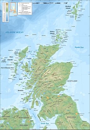
Scotland during the Roman Empire encompasses a period of protohistory
from the arrival of Roman legions in c. AD 71 to their departure in 213. The history of the period is complex: the Roman empire
influenced every part of Scotland during the period, however the occupation was neither complete nor continuous. Analysis and interpretation is further complicated by the fact that the idea of both "Scots
" and of "Scotland
" as a discrete entity did not emerge until centuries later
. The period is marked by the appearance of the first historical accounts
of the peoples of Scotland, as well as by extensive, if at times inconclusive, archaeological evidence.
Throughout this time the geographical area of Scotland was occupied by several different tribes utilising Iron Age
technology with a wide variety of relationships both to one another and to Ancient Rome. The Romans gave the name Caledonia
to the land north of their province of Britannia
, beyond the frontier of the empire. Although the Roman presence was an important time in Scottish history, not least because it was when written records first emerged, Roman influence on Scottish culture was not enduring.
The Roman invasion under Quintus Petillius Cerialis
began in AD 71 and culminated in the battle of Mons Graupius at an unknown location in northern Scotland in AD 84. Although the Caledonia Confederacy
suffered a defeat it was not long before the legions abandoned their territorial gains and returned to a line south of the Solway Firth
, later consolidated by the construction of Hadrian's Wall
.
Roman commanders subsequently made various attempts to conquer territory to the north of this line, including the building of the Antonine Wall
and the later Severan campaigns but their success was similarly short-lived. Roman forces ceased to have a significant impact after 211. By the close of the Roman occupation of southern and central Britain in the fifth century the Picts
had emerged as the dominant force in northern Scotland, with the various Brythonic
tribes the Romans had first encountered there occupying the southern half of the country.
 Scotland had been inhabited for thousands of years before the Romans arrived. However, it is only towards the Roman period that Scotland is recorded in writing.
In the 4th century BC Aristotle
knew of "Albinn" and "Ierne" (the islands of Great Britain
and Ireland
). The Greek explorer Pytheas
visited Britain sometime between 322 and 285 BC and may have circumnavigated the mainland, which he describes as being triangular in shape. In his On the Ocean Pytheas refers to the most northerly point as Orcas, conceivably a reference to Orkney.
The earliest written record of a formal connection between Rome and Scotland is the attendance of the "King of Orkney" who was one of eleven British kings who submitted to the Emperor Claudius
at Colchester
in AD 43 following the invasion of southern Britain three months earlier. The long distances and short period of time involved strongly suggest a prior connection between Rome and Orkney, although no evidence of this has been found and the contrast with later Caledonia
n resistance is striking. Originals of On the Ocean do not survive, but copies are known to have existed in the first century AD so at the least a rudimentary knowledge of the geography of north Britain would have been available to Roman military intelligence. Pomponius Mela
, the Roman geographer, recorded in his De Chorographia, written circa AD 43, that there were thirty Orkney islands and seven Haemodae (possibly Shetland). There is certainly evidence of an Orcadian connection with Rome prior to 60 AD from pottery found at the broch
of Gurness
.
By the time of Pliny the Elder
, who died in AD 79, Roman knowledge of the geography of Scotland had extended to the Hebudes (The Hebrides), Dumna (probably the Outer Hebrides
), the Caledonian Forest
and the Caledonii
.
Ptolemy
, possibly drawing on earlier sources of information as well as more contemporary accounts from the Agricolan
invasion, identified 18 tribes in Scotland in his Geography, but many of the names are obscure and the geography becomes less reliable in the north and west, suggesting early Roman knowledge of these area was confined to observations from the sea.

 Ptolemy's tribes located north of the Forth-Clyde isthmus include the Cornovii
in Caithness
, the Caereni, Smertae, Carnonacae, Decantae, Lugi and Creones also north of the Great Glen
, the Taexali
in the north-east, the Epidii
in Argyll
, the Venicones
in Fife
, the Caledonii in the central Highlands
and the Vacomagi centred near Strathmore
. It is likely that all of these cultures spoke a form of Celtic language known as Pritennic. The occupants of southern Scotland were the Damnonii
in the Clyde valley, the Novantae
in Galloway, the Selgovae
on the south coast and the Votadini
to the east. These peoples may have spoken a form of Brythonic
language.
Despite the discovery of many hundreds of Iron Age
sites in Scotland there is still a great deal that remains to be explained about the nature of the Celtic life in the early Christian era. Unfortunately radiocarbon dating
for this period is problematic and chronological sequences are poorly understood. For a variety of reasons much of the archaeological work to date in Scotland has concentrated on the islands of the west and north
and both excavations and analysis of societal structures on the mainland are more limited in scope.
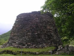
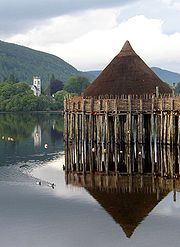
The peoples of early Iron Age Scotland, particularly in the north and west, lived in substantial stone buildings called Atlantic roundhouse
s. The remains of hundreds of these houses exist throughout the country, some merely piles of rubble, others with impressive towers and outbuildings. They date from about 800 BC to AD 300 with the most imposing structures having been created circa 200–100 BC. The most massive constructions that date from this time are the circular broch towers. On average, the ruins only survive up to a few metres above ground level, although there are five extant examples of towers whose walls still exceed 6.5 m (21 ft) in height. There are at least 100 broch sites in Scotland. Despite extensive research, their purpose and the nature of the societies that created them are still a matter of debate.
In some parts of Iron Age Scotland, quite unlike almost all of recorded history right up to the present day, there does not seem to have been an hierarchical elite. Studies have shown that these stone roundhouses, with massively thick walls must have contained virtually the entire population of islands such as Barra
and North Uist
. Iron Age settlement patterns in Scotland are not homogenous, but in these places there is no sign of a privileged class living in large castles or forts, or of an elite priestly caste or of peasants with no access to the kind of accommodation enjoyed by the middle classes.
Over 400 souterrain
s have been discovered in Scotland, many of them in the south-east, and although few have been dated those that have suggest a construction date in the second or third centuries AD. Unfortunately the purpose of these small underground structures is also obscure. They are usually found close to settlements (whose timber frames are much less well-preserved) and may have been for storing perishable agricultural products.
 Scotland also has numerous vitrified fort
s but again an accurate chronology has proven to be evasive. Extensive studies of such a fort at Finavon Hill near Forfar
in Angus
, using a variety of techniques, suggest dates for the destruction of the site in either the last two centuries BC, or the mid-first millennium AD. The lack of Roman artefacts (common in local souterrain sites) suggests that many sites were abandoned before the arrival of the legions.
Unlike the earlier Neolithic
and Bronze Age
s, which have provided massive monuments to the dead, Iron Age burial sites in Scotland are rare, and a recent find at Dunbar
may provide further insight into the culture of this period. A similar site of a warrior's grave at Alloa
has been provisionally dated to AD 90–130. A traveller called Demetrius of Tarsus related to Plutarch
the tale of an expedition to the west coast in or shortly before AD 83. He stated that it was "a gloomy journey amongst uninhabited islands", but that he had visited one which was the retreat of holy men. He mentioned neither the druids nor the name of the island.
had launched an invasion. The Votadini, who occupied the south-east of Scotland, came under Roman sway at an early stage and Cerialis sent one division
north through their territory to the shores of the Firth of Forth
. The XXth Legion took a western route through Annandale
in an attempt to encircle and isolate the Selgovae who occupied the central Southern Uplands
. Early success tempted Cerialis further north and he began constructing a line of Glenblocker fort
s to the north and west of the Gask Ridge
which marked a frontier between the Venicones
to the south and the Caledonii to the north.
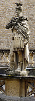
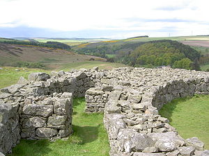
In the summer of AD 78 Gnaeus Julius Agricola
arrived in Britain to take up his appointment as the new governor. Two years later his legions constructed a substantial fort at Trimontium near Melrose. Excavations in the 20th century produced significant finds including the foundations of several successive structures, Roman coins and pottery
. Remains from the Roman army
were also found, including a collection of Roman armour
(with ornate cavalry parade helmets), and horse fittings (with bronze saddleplates and studded leather chamfrons). Agricola is said to have pushed his armies to the estuary of the "River Taus" (usually assumed to be the River Tay
) and established forts there, including a legionary fortress at Inchtuthil
.
. Agricola, whose forces included a fleet, arrived at the site with light infantry
bolstered with British auxiliaries
. It is estimated that a total of 20,000 Romans faced 30,000 Caledonian warrior
s.
 Agricola put his auxiliaries in the front line, keeping the legions in reserve, and relied on close-quarters fighting to make the Caledonians' unpointed slashing swords useless. Even though the Caledonians were put to rout and therefore lost this battle, two thirds of their army managed to escape and hide in the Scottish Highlands or the "trackless wilds" as Tacitus
called them. Battle casualties were estimated by Tacitus to be about 10,000 on the Caledonian side and roughly 360 on the Roman side. A number of authors have reckoned the battle to have occurred in the Grampian Mounth
within sight of the North Sea
. In particular, Roy, Surenne, Watt, Hogan and others have advanced notions that the site of the battle may have been Kempstone Hill
, Megray Hill
or other knolls near the Raedykes
Roman camp
. These points of high ground are proximate to the Elsick Mounth
, an ancient trackway
used by Romans and Caledonians for military manoeuvres. Other suggestions include the hill of Bennachie
in Aberdeenshire, the Gask Ridge
not far from Perth
and Sutherland
. It has also been suggested that in the absence of any archaeological evidence and Tacitus' low estimates of Roman casualties, that the battle was simply fabricated.
("the Swordsman"), a leader of the Caledonians at Mons Graupius, who is referred to by Tacitus in the Agricola (30) as "the most distinguished for birth and valour among the chieftains". Tacitus even invented a speech for him in advance of the battle in which he describes the Romans as:
of the fleet to sail around the north of Scotland to confirm that Britain was an island and to receive the surrender of the Orcadians. It was proclaimed that Agricola had finally subdued all the tribes of Britain. However, the Roman historian Cassius Dio reports that this circumnavigation resulted in Titus
receiving his 15th acclamation as emperor in 79 AD. This is five years before Mons Graupius is believed by most historians to have taken place.
Marching camps may have been constructed along the southern shores of the Moray Firth
, although their existence is questioned. The total size of the Roman garrison in Scotland during the Flavian
period of occupation is thought to be some 25,000 troops, requiring 16–19,000 tons of grain per annum. In addition, the material to construct the forts was substantial, estimated at 1 million cubic feet (28,315 m3) of timber during the first century. Ten tons of buried nails were discovered at the Inchtuthil site, which may have had a garrison of up to 6,000 men and which itself consumed 30 linear kilometres of wood for the walls alone, which would have used up 100 hectares (247 acres) of forest.
Soon after his announcement of victory, Agricola was recalled to Rome by Domitian
and his post passed to Sallustius Lucullus
. Agricola's successors were seemingly unable or unwilling to further subdue the far north. Despite his apparent successes, Agricola himself fell out of favour and it is possible that Domitian may have been informed of the fraudulence of his claims to have won a significant victory. The fortress at Inchtuthil was dismantled before its completion and the other fortifications of the Gask Ridge (erected to consolidate the Roman presence in Scotland in the aftermath of Mons Graupius) were abandoned within the space of a few years. It is possible that the costs of a drawn-out war outweighed any economic or political benefit and it was deemed more profitable to leave the Caledonians to themselves. By AD 87 the occupation was limited to the Southern Uplands and by the end of the first century the northern limit of Roman expansion was a line drawn between the Tyne
and Solway Firth
. Elginhaugh
fort, in Midlothian
, dates to about this period as may Castle Greg
in West Lothian
, which was most likely used as a monitoring base for an east-west road running along the foot of the nearby Pentlands
, from the Forth
to the Clyde Valley.
Presumably as a consequence of the Roman advance, various hill forts such as Dun Mor in Perthshire, which had been abandoned by the natives long ago, were re-occupied. Some new ones may even have been constructed in the north-east such as Hill O' Christ's Kirk in Aberdeenshire
.
 Ptolemy's map identifies 19 "towns" from intelligence gathered during the Agricolan campaigns. No archaeological evidence of any truly urban places has been found from this time and the names may have indicated hill forts or temporary market and meeting places. Most of the names are obscure: Devana may be the modern Banchory
, and Alauna (meaning "the rock") in the west is probably Dumbarton Rock and the place of the same name in the east of the Lowlands may be the site of Edinburgh Castle
. Lindon may be Balloch
on Loch Lomond
side.
There are the remains of various broch towers in southern Scotland that appear to date from the period immediately prior to or following Agricola's invasion. They are about fifteen in number and are found in four locations: the Forth valley, close to the Firth of Tay
, the far south-west and the eastern Borders
. Their existence so far from the main centres of broch-building is something of a mystery. The destruction of the Leckie broch may have come at the hands of the Roman invaders, yet like the nearby site of Fairy Knowe at Buchlyvie
a substantial amount of both Roman and native artefacts have been recovered there. Both structures were built in the late first century AD and were evidently high-status buildings. The inhabitants raised sheep, cattle and pigs, and benefited from a range of wild game including Red Deer
and Wild Boar
.
Edin's Hall Broch
in Berwickshire
is the best preserved southern broch and although the ruins are superficially similar to some of the larger Orcadian broch villages it is unlikely that the tower was ever more than a single story high. There is an absence of Roman artefacts at this site. Various theories for the existence of these structures have been proposed, including their construction by northern invaders following the withdrawal of Roman troops after the Agricolan advance, or by allies of Rome encouraged to emulate the impressive northern style in order to suppress native resistance, perhaps even the Orcadian chiefs whose positive relationship with Rome may have continued from the beginnings of Romano-British relations. It is also possible that their construction had little to do with Roman frontier policy and was simply the importation of a new style by southern elites or it may have been a response by such elites to the growing threat of Rome prior to the invasion and an attempt to ally themselves, actually or symbolically, with the free north.
 Quintus Pompeius Falco
became governor of Brittania between 118 and 122 and is thought to have suppressed an uprising involving the Brigantes
of northern Britannia and the Selgovae. In his last year of office he hosted a visit to the province
by the Emperor Hadrian
that resulted in the construction of Hadrian's Wall
(Latin
: Rigore Valli Aeli, "the line along Hadrian's frontier").
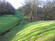
This line of occupation of Britain was consolidated as one of the limites
(defensible frontiers) of the empire by its construction. It is a stone and turf fortification
built across the width of what is now modern-day northern England
. The wall was 80 Roman miles (73.5 statute miles or 117 kilometres) long, its width and height dependent on the construction materials which were available nearby. East of the River Irthing
the wall was made from squared stone and measured 3 metres (9.7 ft) wide and 5–6 metres (16–20 ft) high, while west of the river the wall was made from turf and measured 6 metres (20 ft) wide and 3.5 metres (11.5 ft) high. The wall was augmented by various ditches, berm
s, and forts.
The wall had several purposes. Defence was the most obvious, but it also controlled movement behind the line, enabled the rapid transmission of military intelligence and facilitated the collection of customs dues. Its scale also demonstrated the power of Rome to her enemies, and was surely intended to enhance the prestige of its builder. Hadrian's Wall remained the frontier between the Roman and Celtic worlds in Britain until 139.
was made governor of Roman Britain
in 138, by the new Emperor Antoninus Pius
. Urbicus was the son of a Libyan
landowner and a native of Numidia
(modern Algeria
). Prior to coming to Britain he served during the Jewish Rebellion of 132–135, and then governing Germania Inferior
.
Antoninus Pius soon reversed the containment policy of his predecessor Hadrian, and Urbicus was ordered to begin the reconquest of Lowland Scotland by moving north. Between 139 and 140 he rebuilt a fort at Corbridge
and by 142 or 143, commemorative coins were issued celebrating a victory in Britain. It is therefore likely that Urbicus led the reoccupation of southern Scotland c. 141, probably using Legio II Augusta
. He evidently campaigned against several British tribes (possibly including factions of the northern Brigantes), certainly against the lowland tribes of Scotland
; the Votadini and Selgovae of the Scottish Borders region, and the Damnonii of Strathclyde. His total force may have been about 16,500 men.
It seems likely that Urbicus planned his campaign of attack from Corbridge, advancing north and leaving garrison forts at High Rochester in Northumberland and possibly also at Trimontium as he struck towards the Firth of Forth. Having secured an overland supply route for military personnel and equipment along Dere Street
, Urbicus very likely set up a supply port at Carriden for the supply of grain and other foodstuffs before proceeding against the Damnonii.
 Success was swift and the construction of a new limes between the Firth of Forth and the Firth of Clyde
commenced. Contingents from at least one British legion are known to have assisted in the erection of the new turf barrier, as evidenced by an inscription from the fort at Old Kilpatrick
, the Antonine Wall
's western terminus. Today, the sward-covered wall is the remains of a defensive line made of turf
circa 7 metres (20 ft) high, with nineteen forts. It was constructed after AD 139 and extended for 60 km (37.3 mi). It was possibly after the defences were finished that Urbicus turned his attention upon the fourth lowland Scottish tribe, the Novantae who inhabited the Dumfries and Galloway peninsula. The main lowland tribes, sandwiched as they were between Hadrian's Wall of stone to the south and the new turf wall to the north, later formed a confederation against Roman rule, collectively known as the Maeatae
.
The Antonine Wall had a variety of purposes. It provided a defensive line against the Caledonians. It cut off the Maeatae from their Caledonian allies and created a buffer zone north of Hadrian's Wall. It also facilitated troop movements between east and west, but its main purpose may not have been primarily military. It enabled Rome to control and tax trade and may have prevented potentially disloyal new subjects of Roman rule from communicating with their independent brethren to the north and coordinating revolts. Urbicus achieved an impressive series of military successes, but like Agricola's they were short-lived. Having taken twelve years to build, the wall was over-run and abandoned soon after AD 160.
The destruction of some of the southern brochs may date to the Antonine advance, the hypothesis being that whether or not they had previously been symbols of Roman patronage they had now outlived their usefulness from a Roman point of view.

 Roman troops, however, penetrated far into the north of modern Scotland several more times. Indeed, there is a greater density of Roman marching camps in Scotland than anywhere else in Europe as a result of at least four major attempts to subdue the area. The Antonine Wall was occupied again for a brief period after AD 197. The most notable invasion was in 209 when the emperor Septimus Severus, claiming to be provoked by the belligerence of the Maeatae, campaigned against the Caledonian Confederacy. Severus invaded Caledonia with an army perhaps over 40,000 strong.
 According to Dio Cassius
, he inflicted genocidal depredations on the natives and incurred the loss of 50,000 of his own men to the attrition of guerrilla
tactics, although it is likely that these figures are a significant exaggeration..
A string of forts was constructed in the north-east (some of which may date from the earlier Antonine campaign). These include camps associated with the Elsick Mounth, such as Normandykes
, Ythan Wells
, Deers Den
and Glenmailen. However, only two forts in Scotland, at Cramond
and Carpow (in the Tay valley) are definitely known to have been permanently occupied during this incursion before the troops were withdrawn again to Hadrian's Wall circa 213. There is some evidence that these campaigns are coincident with the wholesale destruction and abandonment of souterrains in southern Scotland. This may have been due either to Roman military aggression or the collapse of local grain markets in the wake of Roman withdrawal.
By 210, Severus' campaigning had made significant gains, but his campaign was cut short when he fell fatally ill, dying at Eboracum
in 211. Although his son Caracalla
continued campaigning the following year, he soon settled for peace. The Romans never campaigned deep into Caledonia again: they soon withdrew south permanently to Hadrian's Wall.
It was during the negotiations to purchase the truce necessary to secure the Roman retreat to the wall that the first recorded utterance, attributable with any reasonable degree of confidence, to a native of Scotland was made. When Septimus Severus' wife, Julia Domna, criticised the sexual morals of the Caledonian women, the wife of Caledonian chief Argentocoxos replied: "We fulfill the demands of nature in a much better way than do you Roman women; for we consort openly with the best men, whereas you let yourselves be debauched in secret by the vilest".
Little is known about this alliance of Iron Age tribes, which may have been augmented by fugitives from Roman rule further south. The exact location of "Caledonia" is unknown, and the boundaries are unlikely to have been fixed. The name itself is a Roman one, as used by Tacitus, Ptolemy, Pliny the Elder and Lucan
, but the name by which the Caledonians referred to themselves is unknown. It is likely that the prior to the Roman invasions, political control in the region was highly decentralised and no evidence has emerged of any specific Caledonian military or political leadership.
Later excursions by the Romans were generally limited to the scouting expeditions in the buffer zone that developed between the walls, trading contacts, bribes to purchase truces from the natives, and eventually the spread of Christianity. The Ravenna Cosmography
utilises a third or fourth century Roman map and identifies four loci (meeting places, possibly markets) in southern Scotland. Locus Maponi is possibly the modern Lochmabenstane near Gretna which continued to be used as a muster point well into the historic period. Two of the others indicate meeting places of the Damnonii and Selgovae, and the fourth, Manavi may be Clackmannan
. From the time of Caracalla onwards, no further attempts were made to permanently occupy territory in Scotland.
 The intermittent Roman presence in Scotland coincided with the emergence of the Picts
, a confederation
of tribes who lived to the north of the Forth and Clyde from Roman times until the 10th century. They are often assumed to have been the descendants of the Caledonii though the evidence for this connection is circumstantial and the name by which the Picts called themselves is unknown. They are often said to have tattooed themselves, but evidence for this is limited. Naturalistic depictions of Pictish nobles, hunters and warriors, male and female, without obvious tattoos, are found on their monumental stones
. The Gaels
of Dalriada called the Picts Cruithne, and Irish poets portrayed their Pictish counterparts as very much like themselves.
The means by which the Pictish confederation formed is also unknown, although there is speculation that reaction to the growth of the Roman Empire was a factor. The early history of Pictland is unclear. In later periods multiple kings existed, ruling over separate kingdoms, with one king, sometimes two, more or less dominating their lesser neighbours. De Situ Albanie
, the Pictish Chronicle
, and the Duan Albanach
, along with Irish legends, have been used to argue the existence of seven Pictish kingdoms although more may have existed and some evidence suggests that a Pictish kingdom also existed in Orkney.
 The Pictish relationship with Rome appears to have been less overtly hostile than their Caledonii predecessors, at least in the beginning. There were no more pitched battles and conflict was generally limited to raiding parties from both sides of the frontier until immediately prior to and after the Roman retreat from Brittania. Their apparent success in holding back Roman forces cannot be explained solely with reference to the remoteness of Caledonia or the difficulties of the terrain. In part it may have been due to the difficulties encountered in subjugating a population that did not conform to the strictures of local governance that Roman power usually depended on to operate through.
The technology of everyday life is not well recorded, but archaeological evidence shows it to have been similar to that in Ireland and Anglo-Saxon England. Recently evidence has been found of watermill
s in Pictland and kiln
s were used for drying kernels of wheat or barley, not otherwise easy in the changeable, temperate climate. Although constructed in earlier times, brochs, roundhouses and crannogs remained in use into and beyond the Pictish period.
Elsewhere in Scotland wheelhouses
were constructed, probably for ritualistic purposes, in the west and north. Their geographical locations are highly restricted, which suggests that they may have been contained within a political or cultural frontier of some kind and the co-incidence of their arrival and departure being associated with the period of Roman influence in Scotland is a matter of ongoing debate. It is not known whether the culture that constructed them was "Pictish" as such although they would certainly have been known to the Picts.
As Rome's power waned, the Picts were emboldened. War bands raided south of Hadrian's Wall in earnest in 342, 360 and 365 and they participated in the conspiratio barbarica
of 367. Rome fought back, mounting campaigns in 369 and 384, but these were short-lived successes. The legions finally deserted Brittania in 410, never to return.
Scotland has inherited two main features from the Roman period, although mostly indirectly: the use of the Roman alphabet for its languages, and the emergence of Christianity
as the predominant religion. Through Christianity, the Latin language would become used by the natives of Scotland for the purposes of church and government for centuries more.
Roman influence assisted the spread of Christianity throughout Europe
, but there is little evidence of a direct link between the Roman Empire and Christian missions north of Hadrian's Wall. Traditionally, Ninian
is credited as the first bishop
active in Scotland. He is briefly mentioned by Bede
who states that around 397 he set up his base at Whithorn
in the south-west of Scotland, building a stone church there, known as Candida Casa
. More recently it has been suggested that Ninian was the 6th century missionary Finnian of Moville
, but either way Roman influence on early Christianity in Scotland does not seem to have been significant.
Although little more than a series of relatively brief interludes of military occupation, Imperial Rome was ruthless and brutal in pursuit of its ends. Genocide was a familiar part of its foreign policy and it is clear that the invasions and occupations cost thousands of lives. Alistair Moffat writes:
All the more surprising given that the Vindolanda tablets
show that the Roman nickname for the north British locals was Brittunculi meaning "nasty little Britons".
Similarly, William Hanson concludes that:
The Romans' part in the clearances of the once extensive Caledonian forest remains a matter of debate. That these forests were once considerably more extensive than they are now is not in dispute, but the timing and causes of the reduction are. The 16th century writer Hector Boece
believed that the woods in Roman times stretched north from Stirling into Atholl
and Lochaber
and was inhabited by white bulls with "crisp and curland mane, like feirs lionis". Later historians such as P. F. Tytler and W. F. Skene followed suit as did the 20th century naturalist Frank Fraser Darling
. Modern techniques, including palynology
and dendrochronology
suggest a more complex picture. Changing post-glacial climates may have allowed for a maximum forest cover between 4000 and 3000 BC and deforestation of the Southern uplands, caused both climatically and anthropogenically, was well underway by the time the legions arrived. Extensive analyses of Black Loch in Fife
suggest that arable land spread at the expense of forest from about 2000 BC until the first century AD Roman advance. Thereafter, there was re-growth of birch, oak and hazel for a period of five centuries, suggesting the invasions had a very negative impact on the native population. The situation outwith the Roman-held areas is harder to assess, but the long-term influence of Rome may not have been substantial.
 The archaeological legacy of Rome in Scotland is of interest, but sparse, especially in the north. Almost all the sites are essentially military in nature and include about 650 km (403.9 mi) of roads. Overall, it is hard to detect any direct connections between native architecture and settlement patterns and Roman influence. Elsewhere in Europe, new kingdoms and languages emerged from the remnants of the once-mighty Roman world. In Scotland, the Celtic Iron Age way of life, often troubled, but never extinguished by Rome, simply re-asserted itself. In the north the Picts continued to be the main power prior to the arrival and subsequent domination of the Scots of Dalriada
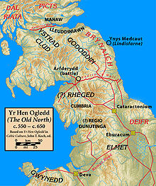
. The Damnonii
eventually formed the Kingdom of Strathclyde
based at Dumbarton Rock
. South of the Forth, the Welsh
speaking Brython
ic kingdoms of Yr Hen Ogledd
(English: "The Old North") flourished during the 5th–7th centuries.
The most enduring Roman legacy may be that created by Hadrian's Wall. Its line approximates the border between modern Scotland and England and it created a distinction between the northern third and southern two-thirds of the island of Great Britain that plays a part in modern political debate. This is probably coincidental however, as there is little to suggest its influence played an important role in the early Medieval period
after the fall of Rome.
participated in the Roman invasion of Britain, suffering losses under Quintus Petillius Cerialis in the rebellion of Boudica
of 61, and setting up a fortress in 71 that later became part of Eburacum. Although some authors have claimed that the 9th Legion disappeared in 117, there are extant records for it later than that year, and it was probably annihilated in the east of the Roman Empire. For a time it was believed, at least by some British historians, that the legion vanished during its conflicts in present-day Scotland. This idea was used in the novels The Eagle of the Ninth
by Rosemary Sutcliff, Legion From the Shadows by Karl Edward Wagner
, Red Shift
by Alan Garner
, Engine City by Ken MacLeod
, Warriors of Alavna by N. M. Browne, and in the feature films The Last Legion
and The Eagle.
at Easter Galcantray
, south west of Cawdor
. The site was excavated between 1984 and 1988 and several features were identified which are supportive of this classification. Roman pottery similar to that found at Inchtuthill Roman fort has been discovered. If confirmed, it would be one of the most northerly known Roman forts in the British Isles.
The possibility that the legions reached further north in Scotland is suggested by discoveries in Easter Ross. The sites of temporary camps have been proposed at Portmahomack
in 1949, although this has not been fully confirmed, and more recently at Tarradale
near the Beauly Firth
.
Protohistory
Protohistory refers to a period between prehistory and history, during which a culture or civilization has not yet developed writing, but other cultures have already noted its existence in their own writings...
from the arrival of Roman legions in c. AD 71 to their departure in 213. The history of the period is complex: the Roman empire
Roman Empire
The Roman Empire was the post-Republican period of the ancient Roman civilization, characterised by an autocratic form of government and large territorial holdings in Europe and around the Mediterranean....
influenced every part of Scotland during the period, however the occupation was neither complete nor continuous. Analysis and interpretation is further complicated by the fact that the idea of both "Scots
Scottish people
The Scottish people , or Scots, are a nation and ethnic group native to Scotland. Historically they emerged from an amalgamation of the Picts and Gaels, incorporating neighbouring Britons to the south as well as invading Germanic peoples such as the Anglo-Saxons and the Norse.In modern use,...
" and of "Scotland
Scotland
Scotland is a country that is part of the United Kingdom. Occupying the northern third of the island of Great Britain, it shares a border with England to the south and is bounded by the North Sea to the east, the Atlantic Ocean to the north and west, and the North Channel and Irish Sea to the...
" as a discrete entity did not emerge until centuries later
Origins of the Kingdom of Alba
The Origins of the Kingdom of Alba pertains to the origins of the Kingdom of Alba, or the Gaelic Kingdom of Scotland, either as a mythological event or a historical process, during the Early Middle Ages.-Medieval version:...
. The period is marked by the appearance of the first historical accounts
Protohistory
Protohistory refers to a period between prehistory and history, during which a culture or civilization has not yet developed writing, but other cultures have already noted its existence in their own writings...
of the peoples of Scotland, as well as by extensive, if at times inconclusive, archaeological evidence.
Throughout this time the geographical area of Scotland was occupied by several different tribes utilising Iron Age
Iron Age
The Iron Age is the archaeological period generally occurring after the Bronze Age, marked by the prevalent use of iron. The early period of the age is characterized by the widespread use of iron or steel. The adoption of such material coincided with other changes in society, including differing...
technology with a wide variety of relationships both to one another and to Ancient Rome. The Romans gave the name Caledonia
Caledonia
Caledonia is the Latinised form and name given by the Romans to the land in today's Scotland north of their province of Britannia, beyond the frontier of their empire...
to the land north of their province of Britannia
Roman Britain
Roman Britain was the part of the island of Great Britain controlled by the Roman Empire from AD 43 until ca. AD 410.The Romans referred to the imperial province as Britannia, which eventually comprised all of the island of Great Britain south of the fluid frontier with Caledonia...
, beyond the frontier of the empire. Although the Roman presence was an important time in Scottish history, not least because it was when written records first emerged, Roman influence on Scottish culture was not enduring.
The Roman invasion under Quintus Petillius Cerialis
Quintus Petillius Cerialis
Quintus Petilius Cerialis Caesius Rufus was a Roman general and administrator who served in Britain during Boudica's rebellion and who went on to participate in the civil wars after the death of Nero. He later defeated the rebellion of Julius Civilis and returned to Britain as its governor.His...
began in AD 71 and culminated in the battle of Mons Graupius at an unknown location in northern Scotland in AD 84. Although the Caledonia Confederacy
Caledonians
The Caledonians , or Caledonian Confederacy, is a name given by historians to a group of indigenous peoples of what is now Scotland during the Iron Age and Roman eras. The Romans referred to their territory as Caledonia and initially included them as Britons, but later distinguished as the Picts...
suffered a defeat it was not long before the legions abandoned their territorial gains and returned to a line south of the Solway Firth
Solway Firth
The Solway Firth is a firth that forms part of the border between England and Scotland, between Cumbria and Dumfries and Galloway. It stretches from St Bees Head, just south of Whitehaven in Cumbria, to the Mull of Galloway, on the western end of Dumfries and Galloway. The Isle of Man is also very...
, later consolidated by the construction of Hadrian's Wall
Hadrian's Wall
Hadrian's Wall was a defensive fortification in Roman Britain. Begun in AD 122, during the rule of emperor Hadrian, it was the first of two fortifications built across Great Britain, the second being the Antonine Wall, lesser known of the two because its physical remains are less evident today.The...
.
Roman commanders subsequently made various attempts to conquer territory to the north of this line, including the building of the Antonine Wall
Antonine Wall
The Antonine Wall is a stone and turf fortification built by the Romans across what is now the Central Belt of Scotland, between the Firth of Forth and the Firth of Clyde. Representing the northernmost frontier barrier of the Roman Empire, it spanned approximately 39 miles and was about ten feet ...
and the later Severan campaigns but their success was similarly short-lived. Roman forces ceased to have a significant impact after 211. By the close of the Roman occupation of southern and central Britain in the fifth century the Picts
Picts
The Picts were a group of Late Iron Age and Early Mediaeval people living in what is now eastern and northern Scotland. There is an association with the distribution of brochs, place names beginning 'Pit-', for instance Pitlochry, and Pictish stones. They are recorded from before the Roman conquest...
had emerged as the dominant force in northern Scotland, with the various Brythonic
Britons (historical)
The Britons were the Celtic people culturally dominating Great Britain from the Iron Age through the Early Middle Ages. They spoke the Insular Celtic language known as British or Brythonic...
tribes the Romans had first encountered there occupying the southern half of the country.
The dawn of Scottish history
In the 4th century BC Aristotle
Aristotle
Aristotle was a Greek philosopher and polymath, a student of Plato and teacher of Alexander the Great. His writings cover many subjects, including physics, metaphysics, poetry, theater, music, logic, rhetoric, linguistics, politics, government, ethics, biology, and zoology...
knew of "Albinn" and "Ierne" (the islands of Great Britain
Great Britain
Great Britain or Britain is an island situated to the northwest of Continental Europe. It is the ninth largest island in the world, and the largest European island, as well as the largest of the British Isles...
and Ireland
Ireland
Ireland is an island to the northwest of continental Europe. It is the third-largest island in Europe and the twentieth-largest island on Earth...
). The Greek explorer Pytheas
Pytheas
Pytheas of Massalia or Massilia , was a Greek geographer and explorer from the Greek colony, Massalia . He made a voyage of exploration to northwestern Europe at about 325 BC. He travelled around and visited a considerable part of Great Britain...
visited Britain sometime between 322 and 285 BC and may have circumnavigated the mainland, which he describes as being triangular in shape. In his On the Ocean Pytheas refers to the most northerly point as Orcas, conceivably a reference to Orkney.
The earliest written record of a formal connection between Rome and Scotland is the attendance of the "King of Orkney" who was one of eleven British kings who submitted to the Emperor Claudius
Claudius
Claudius , was Roman Emperor from 41 to 54. A member of the Julio-Claudian dynasty, he was the son of Drusus and Antonia Minor. He was born at Lugdunum in Gaul and was the first Roman Emperor to be born outside Italy...
at Colchester
Camulodunum
Camulodunum is the Roman name for the ancient settlement which is today's Colchester, a town in Essex, England. Camulodunum is claimed to be the oldest town in Britain as recorded by the Romans, existing as a Celtic settlement before the Roman conquest, when it became the first Roman town, and...
in AD 43 following the invasion of southern Britain three months earlier. The long distances and short period of time involved strongly suggest a prior connection between Rome and Orkney, although no evidence of this has been found and the contrast with later Caledonia
Caledonia
Caledonia is the Latinised form and name given by the Romans to the land in today's Scotland north of their province of Britannia, beyond the frontier of their empire...
n resistance is striking. Originals of On the Ocean do not survive, but copies are known to have existed in the first century AD so at the least a rudimentary knowledge of the geography of north Britain would have been available to Roman military intelligence. Pomponius Mela
Pomponius Mela
Pomponius Mela, who wrote around AD 43, was the earliest Roman geographer. He was born in Tingentera and died c. AD 45.His short work occupies less than one hundred pages of ordinary print. It is laconic in style and deficient in method, but of pure Latinity, and occasionally relieved by pleasing...
, the Roman geographer, recorded in his De Chorographia, written circa AD 43, that there were thirty Orkney islands and seven Haemodae (possibly Shetland). There is certainly evidence of an Orcadian connection with Rome prior to 60 AD from pottery found at the broch
Broch
A broch is an Iron Age drystone hollow-walled structure of a type found only in Scotland. Brochs include some of the most sophisticated examples of drystone architecture ever created, and belong to the classification "complex Atlantic Roundhouse" devised by Scottish archaeologists in the 1980s....
of Gurness
Broch of Gurness
The Broch of Gurness is an Iron Age broch village on the northwest coast of Mainland Orkney in Scotland overlooking Eynhallow Sound. The remains of the central tower are up to high, and the stone walls are up to thick...
.
By the time of Pliny the Elder
Pliny the Elder
Gaius Plinius Secundus , better known as Pliny the Elder, was a Roman author, naturalist, and natural philosopher, as well as naval and army commander of the early Roman Empire, and personal friend of the emperor Vespasian...
, who died in AD 79, Roman knowledge of the geography of Scotland had extended to the Hebudes (The Hebrides), Dumna (probably the Outer Hebrides
Outer Hebrides
The Outer Hebrides also known as the Western Isles and the Long Island, is an island chain off the west coast of Scotland. The islands are geographically contiguous with Comhairle nan Eilean Siar, one of the 32 unitary council areas of Scotland...
), the Caledonian Forest
Caledonian Forest
The Caledonian Forest is the name of a type of woodland that once covered vast areas of Scotland. Today, however, only 1% of the original forest survives, covering in 84 locations. The forests are home to a wide variety of wildlife, much of which is not found elsewhere in the British...
and the Caledonii
Caledonians
The Caledonians , or Caledonian Confederacy, is a name given by historians to a group of indigenous peoples of what is now Scotland during the Iron Age and Roman eras. The Romans referred to their territory as Caledonia and initially included them as Britons, but later distinguished as the Picts...
.
Ptolemy
Ptolemy
Claudius Ptolemy , was a Roman citizen of Egypt who wrote in Greek. He was a mathematician, astronomer, geographer, astrologer, and poet of a single epigram in the Greek Anthology. He lived in Egypt under Roman rule, and is believed to have been born in the town of Ptolemais Hermiou in the...
, possibly drawing on earlier sources of information as well as more contemporary accounts from the Agricolan
Gnaeus Julius Agricola
Gnaeus Julius Agricola was a Roman general responsible for much of the Roman conquest of Britain. His biography, the De vita et moribus Iulii Agricolae, was the first published work of his son-in-law, the historian Tacitus, and is the source for most of what is known about him.Born to a noted...
invasion, identified 18 tribes in Scotland in his Geography, but many of the names are obscure and the geography becomes less reliable in the north and west, suggesting early Roman knowledge of these area was confined to observations from the sea.
Iron Age culture in Scotland
Cornovii (Caithness)
The Cornovii were a people of ancient Britain, known only from a single mention of them by the geographer Ptolemy c. 150. From his description, their territory is reliably known to have been at the northern tip of Scotland, in Caithness. Ptolemy does not provide them with a town or principal place....
in Caithness
Caithness
Caithness is a registration county, lieutenancy area and historic local government area of Scotland. The name was used also for the earldom of Caithness and the Caithness constituency of the Parliament of the United Kingdom . Boundaries are not identical in all contexts, but the Caithness area is...
, the Caereni, Smertae, Carnonacae, Decantae, Lugi and Creones also north of the Great Glen
Great Glen
The Great Glen , also known as Glen Albyn or Glen More is a series of glens in Scotland running 100 kilometres from Inverness on the Moray Firth, to Fort William at the head of Loch Linnhe.The Great Glen follows a large geological fault known as the Great Glen Fault...
, the Taexali
Taexali
The Taexali were a people of ancient Scotland, known only from a single mention of them by the geographer Ptolemy c. 150. From his general description and the approximate location of their town or principal place that he called 'Devana', their territory was along the northeastern coast of Scotland...
in the north-east, the Epidii
Epidii
The Epidii were a people of ancient Britain, known from a mention of them by the geographer Ptolemy c. 150. They inhabited the modern-day regions of Argyll and Kintyre, as well as the islands of Islay and Jura....
in Argyll
Argyll
Argyll , archaically Argyle , is a region of western Scotland corresponding with most of the part of ancient Dál Riata that was located on the island of Great Britain, and in a historical context can be used to mean the entire western coast between the Mull of Kintyre and Cape Wrath...
, the Venicones
Venicones
The Venicones were a people of ancient Britain, known only from a single mention of them by the geographer Ptolemy c. 150 AD. He recorded that their town was 'Orrea'. This has been identified as the Roman fort of Horrea Classis, located by Rivet and Smith as Monifieth, six miles east of Dundee....
in Fife
Fife
Fife is a council area and former county of Scotland. It is situated between the Firth of Tay and the Firth of Forth, with inland boundaries to Perth and Kinross and Clackmannanshire...
, the Caledonii in the central Highlands
Scottish Highlands
The Highlands is an historic region of Scotland. The area is sometimes referred to as the "Scottish Highlands". It was culturally distinguishable from the Lowlands from the later Middle Ages into the modern period, when Lowland Scots replaced Scottish Gaelic throughout most of the Lowlands...
and the Vacomagi centred near Strathmore
Strathmore
Strathmore, from the Scottish Gaelic for large valley , can refer to a number of people, places in Scotland, or places named by Scottish emigrants:-Buildings:...
. It is likely that all of these cultures spoke a form of Celtic language known as Pritennic. The occupants of southern Scotland were the Damnonii
Damnonii
The Damnonii were a people of the late 2nd century who lived in what is now southern Scotland. They are mentioned briefly in Ptolemy's Geography, where he uses both of the terms "Damnonii" and "Damnii" to describe them, and there is no other historical record of them. Their cultural and...
in the Clyde valley, the Novantae
Novantae
The Novantae were a people of the late 2nd century who lived in what is now Galloway and Carrick, in southwestern-most Scotland. They are mentioned briefly in Ptolemy's Geography The Novantae were a people of the late 2nd century who lived in what is now Galloway and Carrick, in southwestern-most...
in Galloway, the Selgovae
Selgovae
The Selgovae were a people of the late 2nd century who lived in what is now the Stewartry of Kirkcudbright and Dumfriesshire, on the southern coast of Scotland. They are mentioned briefly in Ptolemy's Geography, and there is no other historical record of them...
on the south coast and the Votadini
Votadini
The Votadini were a people of the Iron Age in Great Britain, and their territory was briefly part of the Roman province Britannia...
to the east. These peoples may have spoken a form of Brythonic
Brythonic languages
The Brythonic or Brittonic languages form one of the two branches of the Insular Celtic language family, the other being Goidelic. The name Brythonic was derived by Welsh Celticist John Rhys from the Welsh word Brython, meaning an indigenous Briton as opposed to an Anglo-Saxon or Gael...
language.
Despite the discovery of many hundreds of Iron Age
Iron Age
The Iron Age is the archaeological period generally occurring after the Bronze Age, marked by the prevalent use of iron. The early period of the age is characterized by the widespread use of iron or steel. The adoption of such material coincided with other changes in society, including differing...
sites in Scotland there is still a great deal that remains to be explained about the nature of the Celtic life in the early Christian era. Unfortunately radiocarbon dating
Radiocarbon dating
Radiocarbon dating is a radiometric dating method that uses the naturally occurring radioisotope carbon-14 to estimate the age of carbon-bearing materials up to about 58,000 to 62,000 years. Raw, i.e. uncalibrated, radiocarbon ages are usually reported in radiocarbon years "Before Present" ,...
for this period is problematic and chronological sequences are poorly understood. For a variety of reasons much of the archaeological work to date in Scotland has concentrated on the islands of the west and north
Northern Isles
The Northern Isles is a chain of islands off the north coast of mainland Scotland. The climate is cool and temperate and much influenced by the surrounding seas. There are two main island groups: Shetland and Orkney...
and both excavations and analysis of societal structures on the mainland are more limited in scope.
The peoples of early Iron Age Scotland, particularly in the north and west, lived in substantial stone buildings called Atlantic roundhouse
Atlantic roundhouse
In archaeology, an Atlantic roundhouse is an Iron Age stone building found in the northern and western parts of mainland Scotland, the Northern Isles and the Hebrides.-Types of structure:...
s. The remains of hundreds of these houses exist throughout the country, some merely piles of rubble, others with impressive towers and outbuildings. They date from about 800 BC to AD 300 with the most imposing structures having been created circa 200–100 BC. The most massive constructions that date from this time are the circular broch towers. On average, the ruins only survive up to a few metres above ground level, although there are five extant examples of towers whose walls still exceed 6.5 m (21 ft) in height. There are at least 100 broch sites in Scotland. Despite extensive research, their purpose and the nature of the societies that created them are still a matter of debate.
In some parts of Iron Age Scotland, quite unlike almost all of recorded history right up to the present day, there does not seem to have been an hierarchical elite. Studies have shown that these stone roundhouses, with massively thick walls must have contained virtually the entire population of islands such as Barra
Barra
The island of Barra is a predominantly Gaelic-speaking island, and apart from the adjacent island of Vatersay, to which it is connected by a causeway, is the southernmost inhabited island of the Outer Hebrides in Scotland.-Geography:The 2001 census showed that the resident population was 1,078...
and North Uist
North Uist
North Uist is an island and community in the Outer Hebrides of Scotland.-Geography:North Uist is the tenth largest Scottish island and the thirteenth largest island surrounding Great Britain. It has an area of , slightly smaller than South Uist. North Uist is connected by causeways to Benbecula...
. Iron Age settlement patterns in Scotland are not homogenous, but in these places there is no sign of a privileged class living in large castles or forts, or of an elite priestly caste or of peasants with no access to the kind of accommodation enjoyed by the middle classes.
Over 400 souterrain
Souterrain
Souterrain is a name given by archaeologists to a type of underground structure associated mainly with the Atlantic Iron Age. These structures appear to have been brought northwards from Gaul during the late Iron Age. Regional names include earth houses, fogous and Pictish houses...
s have been discovered in Scotland, many of them in the south-east, and although few have been dated those that have suggest a construction date in the second or third centuries AD. Unfortunately the purpose of these small underground structures is also obscure. They are usually found close to settlements (whose timber frames are much less well-preserved) and may have been for storing perishable agricultural products.
Vitrified fort
Vitrified fort is the name given to certain crude stone enclosures whose walls have been subjected in a greater or lesser degree to the action of fire. They are generally situated on hills offering strong defensive positions. Their form seems to have been determined by the contour of the flat...
s but again an accurate chronology has proven to be evasive. Extensive studies of such a fort at Finavon Hill near Forfar
Forfar
Forfar is a parish, town and former royal burgh of approximately 13,500 people in Angus, located in the East Central Lowlands of Scotland. Forfar is the county town of Angus, which was officially known as Forfarshire from the 18th century until 1929, when the ancient name was reinstated, and...
in Angus
Angus
Angus is one of the 32 local government council areas of Scotland, a registration county and a lieutenancy area. The council area borders Aberdeenshire, Perth and Kinross and Dundee City...
, using a variety of techniques, suggest dates for the destruction of the site in either the last two centuries BC, or the mid-first millennium AD. The lack of Roman artefacts (common in local souterrain sites) suggests that many sites were abandoned before the arrival of the legions.
Unlike the earlier Neolithic
Neolithic
The Neolithic Age, Era, or Period, or New Stone Age, was a period in the development of human technology, beginning about 9500 BC in some parts of the Middle East, and later in other parts of the world. It is traditionally considered as the last part of the Stone Age...
and Bronze Age
Bronze Age
The Bronze Age is a period characterized by the use of copper and its alloy bronze as the chief hard materials in the manufacture of some implements and weapons. Chronologically, it stands between the Stone Age and Iron Age...
s, which have provided massive monuments to the dead, Iron Age burial sites in Scotland are rare, and a recent find at Dunbar
Dunbar
Dunbar is a town in East Lothian on the southeast coast of Scotland, approximately 28 miles east of Edinburgh and 28 miles from the English Border at Berwick-upon-Tweed....
may provide further insight into the culture of this period. A similar site of a warrior's grave at Alloa
Alloa
Alloa is a town and former burgh in Clackmannanshire, set in the Central Lowlands of Scotland. It lies on on the north bank of the Firth of Forth close to the foot of the Ochil Hills, east of Stirling and north of Falkirk....
has been provisionally dated to AD 90–130. A traveller called Demetrius of Tarsus related to Plutarch
Plutarch
Plutarch then named, on his becoming a Roman citizen, Lucius Mestrius Plutarchus , c. 46 – 120 AD, was a Greek historian, biographer, essayist, and Middle Platonist known primarily for his Parallel Lives and Moralia...
the tale of an expedition to the west coast in or shortly before AD 83. He stated that it was "a gloomy journey amongst uninhabited islands", but that he had visited one which was the retreat of holy men. He mentioned neither the druids nor the name of the island.
The invasion of Caledonia
The apparently cordial beginnings recorded in Colchester did not last. We know nothing of the foreign policies of the senior leaders in mainland Scotland in the first century, but by AD 71 the Roman governor Quintus Petillius CerialisQuintus Petillius Cerialis
Quintus Petilius Cerialis Caesius Rufus was a Roman general and administrator who served in Britain during Boudica's rebellion and who went on to participate in the civil wars after the death of Nero. He later defeated the rebellion of Julius Civilis and returned to Britain as its governor.His...
had launched an invasion. The Votadini, who occupied the south-east of Scotland, came under Roman sway at an early stage and Cerialis sent one division
Division (military)
A division is a large military unit or formation usually consisting of between 10,000 and 20,000 soldiers. In most armies, a division is composed of several regiments or brigades, and in turn several divisions typically make up a corps...
north through their territory to the shores of the Firth of Forth
Firth of Forth
The Firth of Forth is the estuary or firth of Scotland's River Forth, where it flows into the North Sea, between Fife to the north, and West Lothian, the City of Edinburgh and East Lothian to the south...
. The XXth Legion took a western route through Annandale
Annandale, Dumfries and Galloway
Annandale is a strath in Dumfries and Galloway, Scotland, named after the River Annan. It runs north-south through the Southern Uplands from Annanhead to Annan on the Solway Firth and in its higher reaches it separates the Moffat hills on the east from the Lowther hills to the west...
in an attempt to encircle and isolate the Selgovae who occupied the central Southern Uplands
Southern Uplands
The Southern Uplands are the southernmost and least populous of mainland Scotland's three major geographic areas . The term is used both to describe the geographical region and to collectively denote the various ranges of hills within this region...
. Early success tempted Cerialis further north and he began constructing a line of Glenblocker fort
Glenblocker fort
The term, Glenblocker fort, sometimes also called the Highland line fort is used to describe members of a line of Roman forts along the Highland Line in Scotland...
s to the north and west of the Gask Ridge
Gask Ridge
The Gask Ridge is the modern name given to an early series of fortifications, built by the Romans in Scotland, close to the Highland Line.-Name:...
which marked a frontier between the Venicones
Venicones
The Venicones were a people of ancient Britain, known only from a single mention of them by the geographer Ptolemy c. 150 AD. He recorded that their town was 'Orrea'. This has been identified as the Roman fort of Horrea Classis, located by Rivet and Smith as Monifieth, six miles east of Dundee....
to the south and the Caledonii to the north.
In the summer of AD 78 Gnaeus Julius Agricola
Gnaeus Julius Agricola
Gnaeus Julius Agricola was a Roman general responsible for much of the Roman conquest of Britain. His biography, the De vita et moribus Iulii Agricolae, was the first published work of his son-in-law, the historian Tacitus, and is the source for most of what is known about him.Born to a noted...
arrived in Britain to take up his appointment as the new governor. Two years later his legions constructed a substantial fort at Trimontium near Melrose. Excavations in the 20th century produced significant finds including the foundations of several successive structures, Roman coins and pottery
Pottery
Pottery is the material from which the potteryware is made, of which major types include earthenware, stoneware and porcelain. The place where such wares are made is also called a pottery . Pottery also refers to the art or craft of the potter or the manufacture of pottery...
. Remains from the Roman army
Roman army
The Roman army is the generic term for the terrestrial armed forces deployed by the kingdom of Rome , the Roman Republic , the Roman Empire and its successor, the Byzantine empire...
were also found, including a collection of Roman armour
Armour
Armour or armor is protective covering used to prevent damage from being inflicted to an object, individual or a vehicle through use of direct contact weapons or projectiles, usually during combat, or from damage caused by a potentially dangerous environment or action...
(with ornate cavalry parade helmets), and horse fittings (with bronze saddleplates and studded leather chamfrons). Agricola is said to have pushed his armies to the estuary of the "River Taus" (usually assumed to be the River Tay
River Tay
The River Tay is the longest river in Scotland and the seventh-longest in the United Kingdom. The Tay originates in western Scotland on the slopes of Ben Lui , then flows easterly across the Highlands, through Loch Dochhart, Loch Lubhair and Loch Tay, then continues east through Strathtay , in...
) and established forts there, including a legionary fortress at Inchtuthil
Inchtuthil
Inchtuthil is the site of a Roman legionary fortress situated on a natural platform overlooking the north bank of the River Tay southwest of Blairgowrie, Perth and Kinross, Scotland.It was built in 82 or 83 AD as the advance headquarters for the forces of governor Gnaeus Julius...
.
Mons Graupius
In the summer of AD 84 the Romans faced the massed armies of the Caledonians at the Battle of Mons GraupiusBattle of Mons Graupius
According to Tacitus, the Battle of Mons Graupius took place in AD 83 or, less probably, 84. Gnaeus Julius Agricola, the Roman governor and Tacitus' father-in-law, had sent his fleet ahead to panic the Caledonians, and, with light infantry reinforced with British auxiliaries, reached the site,...
. Agricola, whose forces included a fleet, arrived at the site with light infantry
Light infantry
Traditionally light infantry were soldiers whose job was to provide a skirmishing screen ahead of the main body of infantry, harassing and delaying the enemy advance. Light infantry was distinct from medium, heavy or line infantry. Heavy infantry were dedicated primarily to fighting in tight...
bolstered with British auxiliaries
Auxiliaries (Roman military)
Auxiliaries formed the standing non-citizen corps of the Roman army of the Principate , alongside the citizen legions...
. It is estimated that a total of 20,000 Romans faced 30,000 Caledonian warrior
Warrior
A warrior is a person skilled in combat or warfare, especially within the context of a tribal or clan-based society that recognizes a separate warrior class.-Warrior classes in tribal culture:...
s.
Tacitus
Publius Cornelius Tacitus was a senator and a historian of the Roman Empire. The surviving portions of his two major works—the Annals and the Histories—examine the reigns of the Roman Emperors Tiberius, Claudius, Nero and those who reigned in the Year of the Four Emperors...
called them. Battle casualties were estimated by Tacitus to be about 10,000 on the Caledonian side and roughly 360 on the Roman side. A number of authors have reckoned the battle to have occurred in the Grampian Mounth
Mounth
The Mounth is the range of hills on the southern edge of Strathdee in northeast Scotland. It was usually referred to with the article, i.e. "the Mounth". The name is a corruption of the Scottish Gaelic monadh which in turn is akin to the Welsh mynydd, and may be of Pictish origin...
within sight of the North Sea
North Sea
In the southwest, beyond the Straits of Dover, the North Sea becomes the English Channel connecting to the Atlantic Ocean. In the east, it connects to the Baltic Sea via the Skagerrak and Kattegat, narrow straits that separate Denmark from Norway and Sweden respectively...
. In particular, Roy, Surenne, Watt, Hogan and others have advanced notions that the site of the battle may have been Kempstone Hill
Kempstone Hill
Kempstone Hill is a landform in Aberdeenshire, Scotland within the Mounth Range of the Grampian Mountains. The peak elevation of this mountain is 132 metres above mean sea level. This hill has been posited by Gabriel Jacques Surenne, Archibald Watt and C.Michael Hogan as the location for the...
, Megray Hill
Megray Hill
Megray Hill is a low lying coastal mountainous landform in Aberdeenshire, Scotland within the Mounth Range of the Grampian Mountains. The peak elevation of this mountain is 120 metres above mean sea level. This hill has been posited as a likely location for the noted Battle of Mons Graupius...
or other knolls near the Raedykes
Raedykes
Raedykes is the site of a Roman marching camp located just over 3 miles NW of Stonehaven, Aberdeenshire, Scotland. National Grid Reference NO 842902...
Roman camp
Castra
The Latin word castra, with its singular castrum, was used by the ancient Romans to mean buildings or plots of land reserved to or constructed for use as a military defensive position. The word appears in both Oscan and Umbrian as well as in Latin. It may have descended from Indo-European to Italic...
. These points of high ground are proximate to the Elsick Mounth
Elsick Mounth
The Elsick Mounth is an ancient trackway crossing the Grampian Mountains in the vicinity of Netherley, Scotland. This trackway was one of the few means of traversing the Grampian Mounth area in prehistoric and medieval times. The highest pass of the route is attained within the Durris Forest...
, an ancient trackway
Trackway
A trackway is an ancient route of travel for people or animals. In biology, a trackway can be a set of impressions in the soft earth, usually a set of footprints, left by an animal. A fossil trackway is the fossilized imprint of a trackway. Trackways have been found all over the world...
used by Romans and Caledonians for military manoeuvres. Other suggestions include the hill of Bennachie
Bennachie
Bennachie is a range of hills in Aberdeenshire, Scotland. It has several tops, the highest of which, Oxen Craig, has a height of 528 m...
in Aberdeenshire, the Gask Ridge
Gask Ridge
The Gask Ridge is the modern name given to an early series of fortifications, built by the Romans in Scotland, close to the Highland Line.-Name:...
not far from Perth
Perth, Scotland
Perth is a town and former city and royal burgh in central Scotland. Located on the banks of the River Tay, it is the administrative centre of Perth and Kinross council area and the historic county town of Perthshire...
and Sutherland
Sutherland
Sutherland is a registration county, lieutenancy area and historic administrative county of Scotland. It is now within the Highland local government area. In Gaelic the area is referred to according to its traditional areas: Dùthaich 'IcAoidh , Asainte , and Cataibh...
. It has also been suggested that in the absence of any archaeological evidence and Tacitus' low estimates of Roman casualties, that the battle was simply fabricated.
Calgacus
The first resident of Scotland to appear in history by name was CalgacusCalgacus
According to Tacitus, Calgacus was a chieftain of the Caledonian Confederacy who fought the Roman army of Gnaeus Julius Agricola at the Battle of Mons Graupius in northern Scotland in AD 83 or 84...
("the Swordsman"), a leader of the Caledonians at Mons Graupius, who is referred to by Tacitus in the Agricola (30) as "the most distinguished for birth and valour among the chieftains". Tacitus even invented a speech for him in advance of the battle in which he describes the Romans as:
Aftermath
Calgacus' fate is unknown but, according to Tacitus, after the battle Agricola ordered the prefectPrefect
Prefect is a magisterial title of varying definition....
of the fleet to sail around the north of Scotland to confirm that Britain was an island and to receive the surrender of the Orcadians. It was proclaimed that Agricola had finally subdued all the tribes of Britain. However, the Roman historian Cassius Dio reports that this circumnavigation resulted in Titus
Titus
Titus , was Roman Emperor from 79 to 81. A member of the Flavian dynasty, Titus succeeded his father Vespasian upon his death, thus becoming the first Roman Emperor to come to the throne after his own father....
receiving his 15th acclamation as emperor in 79 AD. This is five years before Mons Graupius is believed by most historians to have taken place.
Marching camps may have been constructed along the southern shores of the Moray Firth
Moray Firth
The Moray Firth is a roughly triangular inlet of the North Sea, north and east of Inverness, which is in the Highland council area of north of Scotland...
, although their existence is questioned. The total size of the Roman garrison in Scotland during the Flavian
Flavian dynasty
The Flavian dynasty was a Roman Imperial Dynasty, which ruled the Roman Empire between 69 and 96 AD, encompassing the reigns of Vespasian , and his two sons Titus and Domitian . The Flavians rose to power during the civil war of 69, known as the Year of the Four Emperors...
period of occupation is thought to be some 25,000 troops, requiring 16–19,000 tons of grain per annum. In addition, the material to construct the forts was substantial, estimated at 1 million cubic feet (28,315 m3) of timber during the first century. Ten tons of buried nails were discovered at the Inchtuthil site, which may have had a garrison of up to 6,000 men and which itself consumed 30 linear kilometres of wood for the walls alone, which would have used up 100 hectares (247 acres) of forest.
Soon after his announcement of victory, Agricola was recalled to Rome by Domitian
Domitian
Domitian was Roman Emperor from 81 to 96. Domitian was the third and last emperor of the Flavian dynasty.Domitian's youth and early career were largely spent in the shadow of his brother Titus, who gained military renown during the First Jewish-Roman War...
and his post passed to Sallustius Lucullus
Sallustius Lucullus
Sallustius Lucullus was a governor of Roman Britain during the late 1st century, holding office after Gnaeus Julius Agricola although it is unclear whether he directly inherited the post or if there was another unknown governor in between...
. Agricola's successors were seemingly unable or unwilling to further subdue the far north. Despite his apparent successes, Agricola himself fell out of favour and it is possible that Domitian may have been informed of the fraudulence of his claims to have won a significant victory. The fortress at Inchtuthil was dismantled before its completion and the other fortifications of the Gask Ridge (erected to consolidate the Roman presence in Scotland in the aftermath of Mons Graupius) were abandoned within the space of a few years. It is possible that the costs of a drawn-out war outweighed any economic or political benefit and it was deemed more profitable to leave the Caledonians to themselves. By AD 87 the occupation was limited to the Southern Uplands and by the end of the first century the northern limit of Roman expansion was a line drawn between the Tyne
River Tyne
The River Tyne is a river in North East England in Great Britain. It is formed by the confluence of two rivers: the North Tyne and the South Tyne. These two rivers converge at Warden Rock near Hexham in Northumberland at a place dubbed 'The Meeting of the Waters'.The North Tyne rises on the...
and Solway Firth
Solway Firth
The Solway Firth is a firth that forms part of the border between England and Scotland, between Cumbria and Dumfries and Galloway. It stretches from St Bees Head, just south of Whitehaven in Cumbria, to the Mull of Galloway, on the western end of Dumfries and Galloway. The Isle of Man is also very...
. Elginhaugh
Elginhaugh
Elginhaugh Roman Fort was a Roman fort of the 1st century AD, located in Midlothian, Scotland.Elginhaugh is the most completely excavated timber-built auxiliary fort in the Roman Empire. The site of the Flavian fort lies 1 km to the west of the modern town of Dalkeith, south-east of Edinburgh...
fort, in Midlothian
Midlothian
Midlothian is one of the 32 council areas of Scotland, and a lieutenancy area. It borders the Scottish Borders, East Lothian and the City of Edinburgh council areas....
, dates to about this period as may Castle Greg
Castle Greg
Castle Greg is the archaeological remains of a Roman fortlet near Camilty Plantation, approximately three miles south-east of West Calder, West Lothian, in Scotland.The site is less than an acre in size, and lies just off the B7008...
in West Lothian
West Lothian
West Lothian is one of the 32 unitary council areas in Scotland, and a Lieutenancy area. It borders the City of Edinburgh, Falkirk, North Lanarkshire, the Scottish Borders and South Lanarkshire....
, which was most likely used as a monitoring base for an east-west road running along the foot of the nearby Pentlands
Pentland Hills
The Pentland Hills are a range of hills to the south-west of Edinburgh, Scotland. The range is around 20 miles in length, and runs south west from Edinburgh towards Biggar and the upper Clydesdale.Some of the peaks include:* Scald Law...
, from the Forth
River Forth
The River Forth , long, is the major river draining the eastern part of the central belt of Scotland.The Forth rises in Loch Ard in the Trossachs, a mountainous area some west of Stirling...
to the Clyde Valley.
Presumably as a consequence of the Roman advance, various hill forts such as Dun Mor in Perthshire, which had been abandoned by the natives long ago, were re-occupied. Some new ones may even have been constructed in the north-east such as Hill O' Christ's Kirk in Aberdeenshire
Aberdeenshire
Aberdeenshire is one of the 32 unitary council areas in Scotland and a lieutenancy area.The present day Aberdeenshire council area does not include the City of Aberdeen, now a separate council area, from which its name derives. Together, the modern council area and the city formed historic...
.
"Towns" and southern brochs
Banchory
Banchory is a burgh or town in Aberdeenshire, Scotland, lying approximately 18 miles west of Aberdeen, near where the Feugh River meets the River Dee.- Overview :...
, and Alauna (meaning "the rock") in the west is probably Dumbarton Rock and the place of the same name in the east of the Lowlands may be the site of Edinburgh Castle
Edinburgh Castle
Edinburgh Castle is a fortress which dominates the skyline of the city of Edinburgh, Scotland, from its position atop the volcanic Castle Rock. Human habitation of the site is dated back as far as the 9th century BC, although the nature of early settlement is unclear...
. Lindon may be Balloch
Balloch
- Places :* Balloch, Highland, Scotland, , is a residential village located 4 miles east of the city of Inverness, Scotland.* Balloch, New Hampshire, United States...
on Loch Lomond
Loch Lomond
Loch Lomond is a freshwater Scottish loch, lying on the Highland Boundary Fault. It is the largest lake in Great Britain by surface area. The lake contains many islands, including Inchmurrin, the largest fresh-water island in the British Isles, although the lake itself is smaller than many Irish...
side.
There are the remains of various broch towers in southern Scotland that appear to date from the period immediately prior to or following Agricola's invasion. They are about fifteen in number and are found in four locations: the Forth valley, close to the Firth of Tay
Firth of Tay
The Firth of Tay is a firth in Scotland between the council areas of Fife, Perth and Kinross, the City of Dundee and Angus, into which Scotland's largest river in terms of flow, the River Tay, empties....
, the far south-west and the eastern Borders
Scottish Borders
The Scottish Borders is one of 32 local government council areas of Scotland. It is bordered by Dumfries and Galloway in the west, South Lanarkshire and West Lothian in the north west, City of Edinburgh, East Lothian, Midlothian to the north; and the non-metropolitan counties of Northumberland...
. Their existence so far from the main centres of broch-building is something of a mystery. The destruction of the Leckie broch may have come at the hands of the Roman invaders, yet like the nearby site of Fairy Knowe at Buchlyvie
Buchlyvie
Buchlyvie is a village in the Stirling council area of Scotland. It is 24 km west of Stirling, south of Flanders Moss in the Carse of Forth. The village lies on the A811, which follows the line of an eighteenth-century military road...
a substantial amount of both Roman and native artefacts have been recovered there. Both structures were built in the late first century AD and were evidently high-status buildings. The inhabitants raised sheep, cattle and pigs, and benefited from a range of wild game including Red Deer
Red Deer
The red deer is one of the largest deer species. Depending on taxonomy, the red deer inhabits most of Europe, the Caucasus Mountains region, Asia Minor, parts of western Asia, and central Asia. It also inhabits the Atlas Mountains region between Morocco and Tunisia in northwestern Africa, being...
and Wild Boar
Boar
Wild boar, also wild pig, is a species of the pig genus Sus, part of the biological family Suidae. The species includes many subspecies. It is the wild ancestor of the domestic pig, an animal with which it freely hybridises...
.
Edin's Hall Broch
Edin's Hall Broch
Edin's Hall Broch is a 2nd century broch near Duns in the Borders of Scotland. It is one of very few brochs found in southern Scotland. It is roughly 27m in diameter.-External links:...
in Berwickshire
Berwickshire
Berwickshire or the County of Berwick is a registration county, a committee area of the Scottish Borders Council, and a lieutenancy area of Scotland, on the border with England. The town after which it is named—Berwick-upon-Tweed—was lost by Scotland to England in 1482...
is the best preserved southern broch and although the ruins are superficially similar to some of the larger Orcadian broch villages it is unlikely that the tower was ever more than a single story high. There is an absence of Roman artefacts at this site. Various theories for the existence of these structures have been proposed, including their construction by northern invaders following the withdrawal of Roman troops after the Agricolan advance, or by allies of Rome encouraged to emulate the impressive northern style in order to suppress native resistance, perhaps even the Orcadian chiefs whose positive relationship with Rome may have continued from the beginnings of Romano-British relations. It is also possible that their construction had little to do with Roman frontier policy and was simply the importation of a new style by southern elites or it may have been a response by such elites to the growing threat of Rome prior to the invasion and an attempt to ally themselves, actually or symbolically, with the free north.
Hadrian's Wall
Quintus Pompeius Falco
Quintus Pompeius Falco was a Roman politician of the early 2nd century.His complete name was Quintus Roscius Coelius Murena Silius Decianus Vibullius Pius Iulius Eurycles Herculanus Pompeius Falco. Pompeius Falco was governor of Moesia Inferior between 116 and 117...
became governor of Brittania between 118 and 122 and is thought to have suppressed an uprising involving the Brigantes
Brigantes
The Brigantes were a Celtic tribe who in pre-Roman times controlled the largest section of what would become Northern England, and a significant part of the Midlands. Their kingdom is sometimes called Brigantia, and it was centred in what was later known as Yorkshire...
of northern Britannia and the Selgovae. In his last year of office he hosted a visit to the province
Roman province
In Ancient Rome, a province was the basic, and, until the Tetrarchy , largest territorial and administrative unit of the empire's territorial possessions outside of Italy...
by the Emperor Hadrian
Hadrian
Hadrian , was Roman Emperor from 117 to 138. He is best known for building Hadrian's Wall, which marked the northern limit of Roman Britain. In Rome, he re-built the Pantheon and constructed the Temple of Venus and Roma. In addition to being emperor, Hadrian was a humanist and was philhellene in...
that resulted in the construction of Hadrian's Wall
Hadrian's Wall
Hadrian's Wall was a defensive fortification in Roman Britain. Begun in AD 122, during the rule of emperor Hadrian, it was the first of two fortifications built across Great Britain, the second being the Antonine Wall, lesser known of the two because its physical remains are less evident today.The...
(Latin
Latin
Latin is an Italic language originally spoken in Latium and Ancient Rome. It, along with most European languages, is a descendant of the ancient Proto-Indo-European language. Although it is considered a dead language, a number of scholars and members of the Christian clergy speak it fluently, and...
: Rigore Valli Aeli, "the line along Hadrian's frontier").
This line of occupation of Britain was consolidated as one of the limites
Limes
A limes was a border defense or delimiting system of Ancient Rome. It marked the boundaries of the Roman Empire.The Latin noun limes had a number of different meanings: a path or balk delimiting fields, a boundary line or marker, any road or path, any channel, such as a stream channel, or any...
(defensible frontiers) of the empire by its construction. It is a stone and turf fortification
Fortification
Fortifications are military constructions and buildings designed for defence in warfare and military bases. Humans have constructed defensive works for many thousands of years, in a variety of increasingly complex designs...
built across the width of what is now modern-day northern England
England
England is a country that is part of the United Kingdom. It shares land borders with Scotland to the north and Wales to the west; the Irish Sea is to the north west, the Celtic Sea to the south west, with the North Sea to the east and the English Channel to the south separating it from continental...
. The wall was 80 Roman miles (73.5 statute miles or 117 kilometres) long, its width and height dependent on the construction materials which were available nearby. East of the River Irthing
River Irthing
The River Irthing is a river in Cumbria, England and a major tributary of the River Eden.Rising in the hills around Paddaburn Moor in Border Forest Park, for the first 15 miles of its journey south it defines the border between Northumberland and Cumbria. After passing Butterburn Flow raised bog,...
the wall was made from squared stone and measured 3 metres (9.7 ft) wide and 5–6 metres (16–20 ft) high, while west of the river the wall was made from turf and measured 6 metres (20 ft) wide and 3.5 metres (11.5 ft) high. The wall was augmented by various ditches, berm
Berm
A berm is a level space, shelf, or raised barrier separating two areas. Berm originates in the Middle Dutch and German berme and came into usage in English via French.- History :...
s, and forts.
The wall had several purposes. Defence was the most obvious, but it also controlled movement behind the line, enabled the rapid transmission of military intelligence and facilitated the collection of customs dues. Its scale also demonstrated the power of Rome to her enemies, and was surely intended to enhance the prestige of its builder. Hadrian's Wall remained the frontier between the Roman and Celtic worlds in Britain until 139.
Antonine Wall
Quintus Lollius UrbicusQuintus Lollius Urbicus
Quintus Lollius Urbicus was governor of Roman Britain between the years 139 and 142, during the reign of the Roman Emperor Antoninus Pius. He is named in the text known as the Augustan History, and his name appears on five Roman inscriptions from Britain; his career is set out in detail on a pair...
was made governor of Roman Britain
Roman Britain
Roman Britain was the part of the island of Great Britain controlled by the Roman Empire from AD 43 until ca. AD 410.The Romans referred to the imperial province as Britannia, which eventually comprised all of the island of Great Britain south of the fluid frontier with Caledonia...
in 138, by the new Emperor Antoninus Pius
Antoninus Pius
Antoninus Pius , also known as Antoninus, was Roman Emperor from 138 to 161. He was a member of the Nerva-Antonine dynasty and the Aurelii. He did not possess the sobriquet "Pius" until after his accession to the throne...
. Urbicus was the son of a Libyan
Ancient Libya
The Latin name Libya referred to the region west of the Nile Valley, generally corresponding to modern Northwest Africa. Climate changes affected the locations of the settlements....
landowner and a native of Numidia
Numidia
Numidia was an ancient Berber kingdom in part of present-day Eastern Algeria and Western Tunisia in North Africa. It is known today as the Chawi-land, the land of the Chawi people , the direct descendants of the historical Numidians or the Massyles The kingdom began as a sovereign state and later...
(modern Algeria
Algeria
Algeria , officially the People's Democratic Republic of Algeria , also formally referred to as the Democratic and Popular Republic of Algeria, is a country in the Maghreb region of Northwest Africa with Algiers as its capital.In terms of land area, it is the largest country in Africa and the Arab...
). Prior to coming to Britain he served during the Jewish Rebellion of 132–135, and then governing Germania Inferior
Germania Inferior
Germania Inferior was a Roman province located on the left bank of the Rhine, in today's Luxembourg, southern Netherlands, parts of Belgium, and North Rhine-Westphalia left of the Rhine....
.
Antoninus Pius soon reversed the containment policy of his predecessor Hadrian, and Urbicus was ordered to begin the reconquest of Lowland Scotland by moving north. Between 139 and 140 he rebuilt a fort at Corbridge
Coria (Corbridge)
Coria was a fort and town, located south of Hadrian's Wall, in the Roman province of Britannia. Its full Latin name is uncertain. Today it is known as Corchester or Corbridge Roman Site, adjoining Corbridge in the English county of Northumberland...
and by 142 or 143, commemorative coins were issued celebrating a victory in Britain. It is therefore likely that Urbicus led the reoccupation of southern Scotland c. 141, probably using Legio II Augusta
Legio II Augusta
Legio secunda Augusta , was a Roman legion, levied by Gaius Vibius Pansa Caetronianus in 43 BC, and still operative in Britannia in the 4th century...
. He evidently campaigned against several British tribes (possibly including factions of the northern Brigantes), certainly against the lowland tribes of Scotland
Scotland
Scotland is a country that is part of the United Kingdom. Occupying the northern third of the island of Great Britain, it shares a border with England to the south and is bounded by the North Sea to the east, the Atlantic Ocean to the north and west, and the North Channel and Irish Sea to the...
; the Votadini and Selgovae of the Scottish Borders region, and the Damnonii of Strathclyde. His total force may have been about 16,500 men.
It seems likely that Urbicus planned his campaign of attack from Corbridge, advancing north and leaving garrison forts at High Rochester in Northumberland and possibly also at Trimontium as he struck towards the Firth of Forth. Having secured an overland supply route for military personnel and equipment along Dere Street
Dere Street
Dere Street or Deere Street, was a Roman road between Eboracum and Veluniate, in what is now Scotland. It still exists in the form of the route of many major roads, including the A1 and A68 just north of Corbridge.Its name corresponds with the post Roman Anglo-Saxon kingdom of Deira, through...
, Urbicus very likely set up a supply port at Carriden for the supply of grain and other foodstuffs before proceeding against the Damnonii.
Firth of Clyde
The Firth of Clyde forms a large area of coastal water, sheltered from the Atlantic Ocean by the Kintyre peninsula which encloses the outer firth in Argyll and Ayrshire, Scotland. The Kilbrannan Sound is a large arm of the Firth of Clyde, separating the Kintyre Peninsula from the Isle of Arran.At...
commenced. Contingents from at least one British legion are known to have assisted in the erection of the new turf barrier, as evidenced by an inscription from the fort at Old Kilpatrick
Old Kilpatrick
Old Kilpatrick is a village in West Dunbartonshire, Scotland.The village is on the north bank of the River Clyde immediately to the north of the Forth and Clyde Canal, three miles from Clydebank on the road to Dumbarton. The Great Western Road runs through Old Kilpatrick, and the next village to...
, the Antonine Wall
Antonine Wall
The Antonine Wall is a stone and turf fortification built by the Romans across what is now the Central Belt of Scotland, between the Firth of Forth and the Firth of Clyde. Representing the northernmost frontier barrier of the Roman Empire, it spanned approximately 39 miles and was about ten feet ...
's western terminus. Today, the sward-covered wall is the remains of a defensive line made of turf
Sod
Sod or turf is grass and the part of the soil beneath it held together by the roots, or a piece of thin material.The term sod may be used to mean turf grown and cut specifically for the establishment of lawns...
circa 7 metres (20 ft) high, with nineteen forts. It was constructed after AD 139 and extended for 60 km (37.3 mi). It was possibly after the defences were finished that Urbicus turned his attention upon the fourth lowland Scottish tribe, the Novantae who inhabited the Dumfries and Galloway peninsula. The main lowland tribes, sandwiched as they were between Hadrian's Wall of stone to the south and the new turf wall to the north, later formed a confederation against Roman rule, collectively known as the Maeatae
Maeatae
The Maeatae were a confederation of tribes who lived probably beyond the Antonine Wall in Roman Britain. The historical sources are vague as to the exact region they inhabited....
.
The Antonine Wall had a variety of purposes. It provided a defensive line against the Caledonians. It cut off the Maeatae from their Caledonian allies and created a buffer zone north of Hadrian's Wall. It also facilitated troop movements between east and west, but its main purpose may not have been primarily military. It enabled Rome to control and tax trade and may have prevented potentially disloyal new subjects of Roman rule from communicating with their independent brethren to the north and coordinating revolts. Urbicus achieved an impressive series of military successes, but like Agricola's they were short-lived. Having taken twelve years to build, the wall was over-run and abandoned soon after AD 160.
The destruction of some of the southern brochs may date to the Antonine advance, the hypothesis being that whether or not they had previously been symbols of Roman patronage they had now outlived their usefulness from a Roman point of view.
Later Roman campaigns
The Roman frontier became Hadrian's Wall again, although Roman incursions into Scotland continued. Initially outpost forts were occupied in the south-west and Trimontium remained in use but they too were abandoned after the mid 180s.Dio Cassius
Lucius Cassius Dio Cocceianus , known in English as Cassius Dio, Dio Cassius, or Dio was a Roman consul and a noted historian writing in Greek...
, he inflicted genocidal depredations on the natives and incurred the loss of 50,000 of his own men to the attrition of guerrilla
Guerrilla warfare
Guerrilla warfare is a form of irregular warfare and refers to conflicts in which a small group of combatants including, but not limited to, armed civilians use military tactics, such as ambushes, sabotage, raids, the element of surprise, and extraordinary mobility to harass a larger and...
tactics, although it is likely that these figures are a significant exaggeration..
A string of forts was constructed in the north-east (some of which may date from the earlier Antonine campaign). These include camps associated with the Elsick Mounth, such as Normandykes
Normandykes
Normandykes is the site of a Roman marching camp to the southwest of Peterculter, Aberdeenshire, Scotland. The near-rectangular site, measuring approximately , covers about of the summit and eastern slopes of a hill overlooking the River Dee and the B9077 road further south. Aerial photographs...
, Ythan Wells
Ythan Wells
Ythan Wells, also known as Glenmailen, is a Roman Camp site situated near the farm of Glenmellan, east of the village of Ythanwells in Aberdeenshire, Scotland....
, Deers Den
Deers Den
Deers Den is an archaeological site at Kintore, Scotland in Aberdeenshire. The site has mesolithic remains, Iron Age artefacts and is a known Roman Camp. This site is partially disturbed and developed by the western part of Kintore itself. The site is associated with the Severan invasion, ca...
and Glenmailen. However, only two forts in Scotland, at Cramond
Cramond
Cramond is a seaside village now part of suburban Edinburgh, Scotland, located in the north-west corner of the city at the mouth of the River Almond where it enters the Firth of Forth....
and Carpow (in the Tay valley) are definitely known to have been permanently occupied during this incursion before the troops were withdrawn again to Hadrian's Wall circa 213. There is some evidence that these campaigns are coincident with the wholesale destruction and abandonment of souterrains in southern Scotland. This may have been due either to Roman military aggression or the collapse of local grain markets in the wake of Roman withdrawal.
By 210, Severus' campaigning had made significant gains, but his campaign was cut short when he fell fatally ill, dying at Eboracum
Eboracum
Eboracum was a fort and city in Roman Britain. The settlement evolved into York, located in North Yorkshire, England.-Etymology:The first known recorded mention of Eboracum by name is dated circa 95-104 AD and is an address containing the Latin form of the settlement's name, "Eburaci", on a wooden...
in 211. Although his son Caracalla
Caracalla
Caracalla , was Roman emperor from 198 to 217. The eldest son of Septimius Severus, he ruled jointly with his younger brother Geta until he murdered the latter in 211...
continued campaigning the following year, he soon settled for peace. The Romans never campaigned deep into Caledonia again: they soon withdrew south permanently to Hadrian's Wall.
It was during the negotiations to purchase the truce necessary to secure the Roman retreat to the wall that the first recorded utterance, attributable with any reasonable degree of confidence, to a native of Scotland was made. When Septimus Severus' wife, Julia Domna, criticised the sexual morals of the Caledonian women, the wife of Caledonian chief Argentocoxos replied: "We fulfill the demands of nature in a much better way than do you Roman women; for we consort openly with the best men, whereas you let yourselves be debauched in secret by the vilest".
Little is known about this alliance of Iron Age tribes, which may have been augmented by fugitives from Roman rule further south. The exact location of "Caledonia" is unknown, and the boundaries are unlikely to have been fixed. The name itself is a Roman one, as used by Tacitus, Ptolemy, Pliny the Elder and Lucan
Marcus Annaeus Lucanus
Marcus Annaeus Lucanus , better known in English as Lucan, was a Roman poet, born in Corduba , in the Hispania Baetica. Despite his short life, he is regarded as one of the outstanding figures of the Imperial Latin period...
, but the name by which the Caledonians referred to themselves is unknown. It is likely that the prior to the Roman invasions, political control in the region was highly decentralised and no evidence has emerged of any specific Caledonian military or political leadership.
Later excursions by the Romans were generally limited to the scouting expeditions in the buffer zone that developed between the walls, trading contacts, bribes to purchase truces from the natives, and eventually the spread of Christianity. The Ravenna Cosmography
Ravenna Cosmography
The Ravenna Cosmography was compiled by an anonymous cleric in Ravenna around AD 700. It consists of a list of place-names covering the world from India to Ireland. Textual evidence indicates that the author frequently used maps as his source....
utilises a third or fourth century Roman map and identifies four loci (meeting places, possibly markets) in southern Scotland. Locus Maponi is possibly the modern Lochmabenstane near Gretna which continued to be used as a muster point well into the historic period. Two of the others indicate meeting places of the Damnonii and Selgovae, and the fourth, Manavi may be Clackmannan
Clackmannan
Clackmannan District 1975-96From 1975, Clackmannan was the name of a small town and local government district in the Central region of Scotland, corresponding to the traditional county of Clackmannanshire, which was Scotland's smallest...
. From the time of Caracalla onwards, no further attempts were made to permanently occupy territory in Scotland.
The Painted Ones
Picts
The Picts were a group of Late Iron Age and Early Mediaeval people living in what is now eastern and northern Scotland. There is an association with the distribution of brochs, place names beginning 'Pit-', for instance Pitlochry, and Pictish stones. They are recorded from before the Roman conquest...
, a confederation
Confederation
A confederation in modern political terms is a permanent union of political units for common action in relation to other units. Usually created by treaty but often later adopting a common constitution, confederations tend to be established for dealing with critical issues such as defense, foreign...
of tribes who lived to the north of the Forth and Clyde from Roman times until the 10th century. They are often assumed to have been the descendants of the Caledonii though the evidence for this connection is circumstantial and the name by which the Picts called themselves is unknown. They are often said to have tattooed themselves, but evidence for this is limited. Naturalistic depictions of Pictish nobles, hunters and warriors, male and female, without obvious tattoos, are found on their monumental stones
Pictish stones
Pictish stones are monumental stelae found in Scotland, mostly north of the Clyde-Forth line. These stones are the most visible remaining evidence of the Picts and are thought to date from the 6th to 9th centuries, a period during which the Picts became Christianized...
. The Gaels
Gaels
The Gaels or Goidels are speakers of one of the Goidelic Celtic languages: Irish, Scottish Gaelic, and Manx. Goidelic speech originated in Ireland and subsequently spread to western and northern Scotland and the Isle of Man....
of Dalriada called the Picts Cruithne, and Irish poets portrayed their Pictish counterparts as very much like themselves.
The means by which the Pictish confederation formed is also unknown, although there is speculation that reaction to the growth of the Roman Empire was a factor. The early history of Pictland is unclear. In later periods multiple kings existed, ruling over separate kingdoms, with one king, sometimes two, more or less dominating their lesser neighbours. De Situ Albanie
De Situ Albanie
De Situ Albanie is the name given to the first of seven Scottish documents found in the so-called Poppleton Manuscript, now in the Bibliothèque Nationale, Paris...
, the Pictish Chronicle
Pictish Chronicle
The Pictish Chronicle is a name often given by historians to a list of the kings of the Picts beginning many thousand years before history was recorded in Pictavia and ending after Pictavia had been enveloped by Scotland...
, and the Duan Albanach
Duan Albanach
The Duan Albanach is a Middle Gaelic poem found with the Lebor Bretnach, a Gaelic version of the Historia Brittonum of Nennius, with extensive additional material ....
, along with Irish legends, have been used to argue the existence of seven Pictish kingdoms although more may have existed and some evidence suggests that a Pictish kingdom also existed in Orkney.
The technology of everyday life is not well recorded, but archaeological evidence shows it to have been similar to that in Ireland and Anglo-Saxon England. Recently evidence has been found of watermill
Watermill
A watermill is a structure that uses a water wheel or turbine to drive a mechanical process such as flour, lumber or textile production, or metal shaping .- History :...
s in Pictland and kiln
Kiln
A kiln is a thermally insulated chamber, or oven, in which a controlled temperature regime is produced. Uses include the hardening, burning or drying of materials...
s were used for drying kernels of wheat or barley, not otherwise easy in the changeable, temperate climate. Although constructed in earlier times, brochs, roundhouses and crannogs remained in use into and beyond the Pictish period.
Elsewhere in Scotland wheelhouses
Wheelhouse (archaeology)
In archaeology, a wheelhouse is a prehistoric structure from the Iron Age found in Scotland. The term was first coined after the discovery of a ruined mound in 1855. The distinctive architectural form related to the complex roundhouses, constitute the main settlement type in the Western Isles, in...
were constructed, probably for ritualistic purposes, in the west and north. Their geographical locations are highly restricted, which suggests that they may have been contained within a political or cultural frontier of some kind and the co-incidence of their arrival and departure being associated with the period of Roman influence in Scotland is a matter of ongoing debate. It is not known whether the culture that constructed them was "Pictish" as such although they would certainly have been known to the Picts.
As Rome's power waned, the Picts were emboldened. War bands raided south of Hadrian's Wall in earnest in 342, 360 and 365 and they participated in the conspiratio barbarica
Great Conspiracy
The Great Conspiracy is a term given to a year-long war that occurred in Roman Britain near the end of the Roman occupation of the island. The historian Ammianus Marcellinus described it as a barbarica conspiratio that capitalized on a depleted military force in the province brought about by...
of 367. Rome fought back, mounting campaigns in 369 and 384, but these were short-lived successes. The legions finally deserted Brittania in 410, never to return.
Roman legacy
The military presence of Rome lasted for little more than 40 years for most of Scotland and only as much as 80 years in total anywhere. At no time was even half of Scotland's land mass under Roman control.Scotland has inherited two main features from the Roman period, although mostly indirectly: the use of the Roman alphabet for its languages, and the emergence of Christianity
Christianity
Christianity is a monotheistic religion based on the life and teachings of Jesus as presented in canonical gospels and other New Testament writings...
as the predominant religion. Through Christianity, the Latin language would become used by the natives of Scotland for the purposes of church and government for centuries more.
Roman influence assisted the spread of Christianity throughout Europe
Europe
Europe is, by convention, one of the world's seven continents. Comprising the westernmost peninsula of Eurasia, Europe is generally 'divided' from Asia to its east by the watershed divides of the Ural and Caucasus Mountains, the Ural River, the Caspian and Black Seas, and the waterways connecting...
, but there is little evidence of a direct link between the Roman Empire and Christian missions north of Hadrian's Wall. Traditionally, Ninian
Saint Ninian
Saint Ninian is a Christian saint first mentioned in the 8th century as being an early missionary among the Pictish peoples of what is now Scotland...
is credited as the first bishop
Bishop
A bishop is an ordained or consecrated member of the Christian clergy who is generally entrusted with a position of authority and oversight. Within the Catholic Church, Eastern Orthodox, Oriental Orthodox Churches, in the Assyrian Church of the East, in the Independent Catholic Churches, and in the...
active in Scotland. He is briefly mentioned by Bede
Bede
Bede , also referred to as Saint Bede or the Venerable Bede , was a monk at the Northumbrian monastery of Saint Peter at Monkwearmouth, today part of Sunderland, England, and of its companion monastery, Saint Paul's, in modern Jarrow , both in the Kingdom of Northumbria...
who states that around 397 he set up his base at Whithorn
Whithorn
Whithorn is a former royal burgh in Dumfries and Galloway, Scotland, about ten miles south of Wigtown. The town was the location of the first recorded Christian church in Scotland, Candida Casa : the 'White [or 'Shining'] House', built by Saint Ninian about 397.-Eighth and twelfth centuries:A...
in the south-west of Scotland, building a stone church there, known as Candida Casa
Candida Casa
Candida Casa was the name given to the church established by St Ninian in Whithorn, Galloway, southern Scotland, in the mid fifth century AD. The name derives from and / , referring possibly to the stone used to construct it, or the whitewash used to paint it.The church site quickly grew to...
. More recently it has been suggested that Ninian was the 6th century missionary Finnian of Moville
Finnian of Moville
Finnian of Movilla Abbey, Irish Christian missionary, 495–589.-Origins and life:Finnian was a Christian missionary who became a legendary figure in medieval Ireland. He should not to be confused with his namesake Finnian of Clonard...
, but either way Roman influence on early Christianity in Scotland does not seem to have been significant.
Although little more than a series of relatively brief interludes of military occupation, Imperial Rome was ruthless and brutal in pursuit of its ends. Genocide was a familiar part of its foreign policy and it is clear that the invasions and occupations cost thousands of lives. Alistair Moffat writes:
All the more surprising given that the Vindolanda tablets
Vindolanda tablets
The Vindolanda tablets are "the oldest surviving handwritten documents in Britain". They are also probably our best source of information about life on Hadrian's Wall. Written on fragments of thin, post-card sized wooden leaf-tablets with carbon-based ink, the tablets date to the 1st and 2nd...
show that the Roman nickname for the north British locals was Brittunculi meaning "nasty little Britons".
Similarly, William Hanson concludes that:
The Romans' part in the clearances of the once extensive Caledonian forest remains a matter of debate. That these forests were once considerably more extensive than they are now is not in dispute, but the timing and causes of the reduction are. The 16th century writer Hector Boece
Hector Boece
Hector Boece , known in Latin as Hector Boecius or Boethius, was a Scottish philosopher and first Principal of King's College in Aberdeen, a predecessor of the University of Aberdeen.-Biography:He was born in Dundee where he attended school...
believed that the woods in Roman times stretched north from Stirling into Atholl
Atholl
Atholl or Athole is a large historical division in the Scottish Highlands. Today it forms the northern part of Perth and Kinross, Scotland bordering Marr, Badenoch, Breadalbane, Strathearn, Perth and Lochaber....
and Lochaber
Lochaber
District of Lochaber 1975 to 1996Highland council area shown as one of the council areas of ScotlandLochaber is one of the 16 ward management areas of the Highland Council of Scotland and one of eight former local government districts of the two-tier Highland region...
and was inhabited by white bulls with "crisp and curland mane, like feirs lionis". Later historians such as P. F. Tytler and W. F. Skene followed suit as did the 20th century naturalist Frank Fraser Darling
Frank Fraser Darling
Sir Frank Fraser Darling was an English ecologist, ornithologist, farmer, conservationist and author, who is strongly associated with the highlands and islands of Scotland.-Early life:...
. Modern techniques, including palynology
Palynology
Palynology is the science that studies contemporary and fossil palynomorphs, including pollen, spores, orbicules, dinoflagellate cysts, acritarchs, chitinozoans and scolecodonts, together with particulate organic matter and kerogen found in sedimentary rocks and sediments...
and dendrochronology
Dendrochronology
Dendrochronology or tree-ring dating is the scientific method of dating based on the analysis of patterns of tree-rings. Dendrochronology can date the time at which tree rings were formed, in many types of wood, to the exact calendar year...
suggest a more complex picture. Changing post-glacial climates may have allowed for a maximum forest cover between 4000 and 3000 BC and deforestation of the Southern uplands, caused both climatically and anthropogenically, was well underway by the time the legions arrived. Extensive analyses of Black Loch in Fife
Fife
Fife is a council area and former county of Scotland. It is situated between the Firth of Tay and the Firth of Forth, with inland boundaries to Perth and Kinross and Clackmannanshire...
suggest that arable land spread at the expense of forest from about 2000 BC until the first century AD Roman advance. Thereafter, there was re-growth of birch, oak and hazel for a period of five centuries, suggesting the invasions had a very negative impact on the native population. The situation outwith the Roman-held areas is harder to assess, but the long-term influence of Rome may not have been substantial.
Dalriada
Dalriada can refer to:* Dál Riata, a Gaelic kingdom in western Scotland and north-east Ireland in the Early Middle Ages* Dalriada School, a co-educational, voluntary grammar school in Ballymoney, Northern Ireland* Dalriada , Hungarian folk metal band...
. The Damnonii
Damnonii
The Damnonii were a people of the late 2nd century who lived in what is now southern Scotland. They are mentioned briefly in Ptolemy's Geography, where he uses both of the terms "Damnonii" and "Damnii" to describe them, and there is no other historical record of them. Their cultural and...
eventually formed the Kingdom of Strathclyde
Kingdom of Strathclyde
Strathclyde , originally Brythonic Ystrad Clud, was one of the early medieval kingdoms of the celtic people called the Britons in the Hen Ogledd, the Brythonic-speaking parts of what is now southern Scotland and northern England. The kingdom developed during the post-Roman period...
based at Dumbarton Rock
Dumbarton Castle
Dumbarton Castle has the longest recorded history of any stronghold in Great Britain. It overlooks the Scottish town of Dumbarton, and sits on a plug of volcanic basalt known as Dumbarton Rock which is high.-Iron Age:...
. South of the Forth, the Welsh
Welsh language
Welsh is a member of the Brythonic branch of the Celtic languages spoken natively in Wales, by some along the Welsh border in England, and in Y Wladfa...
speaking Brython
Brython
The Britons were the Celtic people culturally dominating Great Britain from the Iron Age through the Early Middle Ages. They spoke the Insular Celtic language known as British or Brythonic...
ic kingdoms of Yr Hen Ogledd
Hen Ogledd
Yr Hen Ogledd is a Welsh term used by scholars to refer to those parts of what is now northern England and southern Scotland in the years between 500 and the Viking invasions of c. 800, with particular interest in the Brythonic-speaking peoples who lived there.The term is derived from heroic...
(English: "The Old North") flourished during the 5th–7th centuries.
The most enduring Roman legacy may be that created by Hadrian's Wall. Its line approximates the border between modern Scotland and England and it created a distinction between the northern third and southern two-thirds of the island of Great Britain that plays a part in modern political debate. This is probably coincidental however, as there is little to suggest its influence played an important role in the early Medieval period
Scotland in the Early Middle Ages
Scotland in the early Middle Ages, between the end of Roman authority in southern and central Britain from around 400 and the rise of the kingdom of Alba in 900, was divided into a series of petty kingdoms. Of these the four most important to emerge were the Picts, the Scots of Dál Riata, the...
after the fall of Rome.
In fiction
The 9th Spanish LegionLegio IX Hispana
Legio Nona Hispana was a Roman legion, which operated from the first century BCE until mid 2nd century CE. The Spanish Legion's disappearance has raised speculations over its fate, largely of its alleged destruction in Scotland in about 117 CE, though some scholars believe it was destroyed in the...
participated in the Roman invasion of Britain, suffering losses under Quintus Petillius Cerialis in the rebellion of Boudica
Boudica
Boudica , also known as Boadicea and known in Welsh as "Buddug" was queen of the British Iceni tribe who led an uprising against the occupying forces of the Roman Empire....
of 61, and setting up a fortress in 71 that later became part of Eburacum. Although some authors have claimed that the 9th Legion disappeared in 117, there are extant records for it later than that year, and it was probably annihilated in the east of the Roman Empire. For a time it was believed, at least by some British historians, that the legion vanished during its conflicts in present-day Scotland. This idea was used in the novels The Eagle of the Ninth
The Eagle of the Ninth
The Eagle of the Ninth is a historical adventure novel for children written by Rosemary Sutcliff and published in 1954. The story is set in Roman Britain in the 2nd century AD, after the building of Hadrian's Wall....
by Rosemary Sutcliff, Legion From the Shadows by Karl Edward Wagner
Karl Edward Wagner
Karl Edward Wagner was an American writer, editor and publisher of horror, science fiction, and heroic fantasy, who was born in Knoxville, Tennessee and originally trained as a psychiatrist. His disillusionment with the medical profession can be seen in the stories "The Fourth Seal" and "Into...
, Red Shift
Red Shift (novel)
Red Shift is a fantasy novel by Alan Garner. It spans over a thousand years but one geographical area: Southern Cheshire, England. Garner evokes the essence of place, allowing his characters to echo each other through time, as if their destinies may be predefined by the soil on which they walk...
by Alan Garner
Alan Garner
With his first book published, Garner abandoned his work as a labourer and gained a job as a freelance television reporter, living a "hand to mouth" lifestyle on a "shoestring" budget...
, Engine City by Ken MacLeod
Ken MacLeod
Ken MacLeod , is a Scottish science fiction writer.MacLeod was born in Stornoway. He graduated from Glasgow University with a degree in zoology and has worked as a computer programmer and written a masters thesis on biomechanics....
, Warriors of Alavna by N. M. Browne, and in the feature films The Last Legion
The Last Legion
The Last Legion is a 2007 film directed by Doug Lefler. Produced by Dino De Laurentiis and others, it is based on a 2003 Italian novel of the same name written by Valerio Massimo Manfredi...
and The Eagle.
Recent discoveries
In 1984, a candidate for a Roman fort was identified by aerial photographyAerial photography
Aerial photography is the taking of photographs of the ground from an elevated position. The term usually refers to images in which the camera is not supported by a ground-based structure. Cameras may be hand held or mounted, and photographs may be taken by a photographer, triggered remotely or...
at Easter Galcantray
Cawdor (Roman Fort)
Cawdor , located near the small village of Eastern Galcantray , is suspected of being one of the northernmost Roman forts in Great Britain, though this evidence is controversial.-History:...
, south west of Cawdor
Cawdor
Cawdor is a village and parish in Nairnshire, Highland council area, Scotland. The village is situated 5 miles south south west of Nairn, and 12 miles from Inverness.-History:The village is the location of Cawdor Castle, the seat of the Earl Cawdor....
. The site was excavated between 1984 and 1988 and several features were identified which are supportive of this classification. Roman pottery similar to that found at Inchtuthill Roman fort has been discovered. If confirmed, it would be one of the most northerly known Roman forts in the British Isles.
The possibility that the legions reached further north in Scotland is suggested by discoveries in Easter Ross. The sites of temporary camps have been proposed at Portmahomack
Portmahomack
Portmahomack is a small fishing village in Easter Ross, Scotland. It is situated in the Tarbat Peninsula in the parish of Tarbat. Tarbat Ness Lighthouse is about three miles from the village at the end of the Tarbat Peninsula. Ballone Castle lies about a mile from the village...
in 1949, although this has not been fully confirmed, and more recently at Tarradale
Muir of Tarradale
Muir of Tarradale is a scattered crofting township, lying 1.5 miles east of Muir of Ord on the western side of the Black Isle, in Ross-shire, Scottish Highlands and is in the Scottish council area of Highland....
near the Beauly Firth
Beauly Firth
The Beauly Firth is a firth in northern Scotland. It is effectively a continuation of the Moray Firth westward, and is bounded at one end by Beauly and at the other by Inverness . The Kessock Ferry has crossed at the eastern end since the 15th Century...
.
See also
- Timeline of prehistoric ScotlandTimeline of prehistoric ScotlandThis timeline of prehistoric Scotland is a chronologically ordered list of important archaeological sites in Scotland and of major events affecting Scotland's human inhabitants and culture during the prehistoric period. The period of prehistory prior to occupation by the genus Homo is part of the...
- Roman client kingdoms in BritainRoman client kingdoms in BritainThe Roman client kingdoms in Britain were native tribes who chose to align themselves with the Roman Empire because they saw it as the best option for self-preservation or for protection from other hostile tribes...
- Celtic tribes in Britain and Ireland
- ScotiScotiScoti or Scotti was the generic name used by the Romans to describe those who sailed from Ireland to conduct raids on Roman Britain. It was thus synonymous with the modern term Gaels...
- HiberniaHiberniaHibernia is the Classical Latin name for the island of Ireland. The name Hibernia was taken from Greek geographical accounts. During his exploration of northwest Europe , Pytheas of Massilia called the island Ierne . In his book Geographia Hibernia is the Classical Latin name for the island of...
- Great ConspiracyGreat ConspiracyThe Great Conspiracy is a term given to a year-long war that occurred in Roman Britain near the end of the Roman occupation of the island. The historian Ammianus Marcellinus described it as a barbarica conspiratio that capitalized on a depleted military force in the province brought about by...
- a year-long war that occurred towards the end of the Roman occupation of Britain in 367. - AttacottiAttacottiAttacotti refers to a people who despoiled Roman Britain between 364 and 368, along with Scotti, Picts, Saxons, Roman military deserters, and the indigenous Britons themselves. The marauders were defeated by Count Theodosius in 368...
- participants in the Great Conspiracy - Valentia (Roman Britain)Valentia (Roman Britain)Valentia was the name of a consular northern province of Roman Britain.-History:Count Theodosius set up Valentia in 369 AD as part of his reorganisation of Britain following the Great Conspiracy, and probably named it after the reigning emperors, Valentinian and Valens.Ammianus tells of how the...
- Possible independent British (Votadini, Selgovae, Novantae, Damnonii) province in the Borders acting as free agents of Rome. - Prehistoric OrkneyPrehistoric OrkneyPrehistoric Orkney refers to a period in the human occupation of the Orkney archipelago of Scotland that was the latter part of these islands' prehistory. The period of prehistory prior to occupation by the genus Homo is part of the geology of Scotland...
Further reading
- Kamm, Anthony (2009) The Last Frontier: The Roman Invasions of Scotland. Glasgow. Neil Wilson Publishing. ISBN 9781906476069
External links
- Comparison of the geography of Scotland recorded in the Ravenna Cosmography with Ptolemy's
- The Antonine Wall: The North-west Frontier of the Roman Empire
- Roman Scotland, which provides a full analysis of the contending sites for Mons Graupius