
Anstey Hill Recreation Park
Encyclopedia
Anstey Hill Recreation Park is a 362 hectares (894.5 acre) public park approximately 19 kilometres (11.8 mi) northeast of Adelaide
, South Australia
. It is managed by the City of Tea Tree Gully
, the Department for Environment and Heritage
and a volunteer group—The Friends of Anstey Hill
. The park is designed for recreational walking and there are no visitor facilities. It is part of Yurrebilla, the Greater Mount Lofty Parklands, and is a significant reserve of bushland
in the foothills of the Mount Lofty Ranges
. Anstey Hill Recreation Park is home to rare or vulnerable native plants and animals, and problematic invasive species.
The park's land was gradually acquired by the Government of South Australia
beginning in 1966, based on recommendations in a 1962 report. From 1981 onwards, plans were published that aimed to develop the area for commercial purposes, but public pressure led to its declaration as a public reserve in 1989. The last land added was a small area in 2003. Anstey Hill is a 371 metres (1,217.2 ft) high peak in the park's south. Both hill and park are named after a road built by agricultural pioneer George Alexander Anstey
. Fire authorities regard the park as an "arson
hotspot", and it is frequently burned by bushfires—mostly deliberately lit. There is no permanent water except for springs
in Water Gully, adjacent to ruins of a nursery
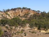
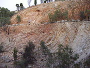
, although there are many seasonal creeks. Much of the land is steep, rising 200 m (656.2 ft) across the park's breadth, with gradients often steeper than one in three. Erosion and land movements due to a significant geologic fault zone created this land form. The Gun Emplacement, a listed Geologic Monument and remnant of an ancient land surface, lies in the southwestern corner.
The Adelaide–Mannum
pipeline crosses the park and the Anstey Hill water filtration
plant lies on its southern boundary; together they supply 20% of Adelaide's reticulated water. Significant historical uses of the area are preserved as ruins and highlighted with interpretive signs. The ruins of Newman's Nursery are all that remains of what was once the largest plant nursery in the Southern Hemisphere. Ellis Cottage is one of the earliest homes in the area, and the Rumps Bakery building housed the first bakery in Tea Tree Gully
. Quarries supplied stone for significant Victorian
buildings in Adelaide and aggregate
for road building. Klopper's quarries in the southwest hosted plays for the Festival of the Arts
in 1980 and 1988.
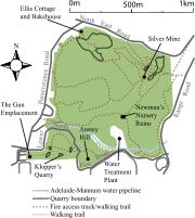 Anstey Hill Recreation Park is a reserved area of public land with short seasonal creeks, low hills and steep-sided gullies. Its boundaries are largely formed by Lower North East, North East, Perseverance and Range Roads; there is a small section south of Lower North East Road. It lies at the edge of the Mount Lofty Ranges
' foothills and forms part of the "hill's face" that is visible from Adelaide's metropolitan area. The park covers 362 hectares (894.5 acre) of the City of Tea Tree Gully, approximately 19 km (11.8 mi) northeast of Adelaide's central business district
, with parts in the suburbs of Tea Tree Gully
, Vista
, Highbury
and Houghton
. The Adelaide–Mannum water supply pipeline crosses the park's south, and an associated filtration plant is sited on its southern boundary. Adjacent to the water filtration plant is Anstey Hill, reaching 371.1 m (1,217.5 ft) above mean sea level
. The hill is 50 m (164 ft) shorter than a nearby unnamed peak. The park’s southern boundary abuts the Anstey Hill Quarry, a producer of white clay, and two large disused quarries.
The park is part of the Greater Mount Lofty Parklands, an area also known as Yurrebilla. Management of the park is influenced by the Department for Environment and Heritage's long term biodiversity goals for the hill face zone. The Department manages the park in association with local council and a volunteer group—The Friends of Anstey Hill. This volunteer group makes significant contributions to revegetation
, weed control, ruin stabilisation and creation of walking trails. There are no visitor facilities or amenities except for walking trails, most of which follow fire access tracks; a single constructed pedestrian trail leads to Klopper’s Quarry. The park is mostly designated as a "conservation zone" where only passive recreation, including walking dogs on leads, is permitted. Horses and motor vehicles are not allowed and only the main tracks are maintained.
In recognition of the established and popular activity of mountain biking in the greater Adelaide area, and to better accommodate the mountain biking community in the North Eastern suburbs, the Department for Environment and Heritage has proposed to permit cycling in designated zones on purpose-built tracks and on certain management tracks within the park. The intention is to satisfy both biodiversity and recreation objectives in the park and reducing the incidence of illegal mountain bike riding in other non designated areas.
Anstey Hill Park lies between Bureau of Meteorology measured rainfall contour lines that denote an annual average from 580 to 820 mm (22.8 to 32.3 in). It has hot dry summers, as does all of Adelaide, and December to February's average maximum daily temperatures 28 °C (82 °F) to 29 °C (84 °F). Temperatures drop significantly in the wetter winters; July's average maximum temperature is 14.6 °C (58.3 °F). Apart from springs in Water Gully, the site of Newman's Nursery ruins, all of the numerous creeks in the park are seasonal and dry for much of the year. The park rises from approximately 220 m (721.8 ft) above mean sea level on its western side to 420 m (1,378 ft) at the highest point in the park's southeast corner. Most of the park is steeply sloping with gradients steeper than one in four. Except for the base of Water Gully, topsoil throughout the park is shallow and low in plant nutrients.
There are frequent serious bushfires in the park. Much of the reserve was burned in 1980, eastern parts burned in 1981, and most of the park burned again in the 1983 Ash Wednesday fires
; Newman's Nursery's remains were devastated during the 1983 bushfire. As recently as 2004, a major fire burned over 100 ha (247 acre) of bushland next to Anstey Hill. Most fires in the park are deliberately lit and the park is regarded as a "hotspot" for arson
. Arson in the park is not a recent phenomenon; an early record comes from an 1869 coronial
inquiry. The park has more than one arson attack, on average, each year. In the hill's face, encompassing Anstey Hill, approximately 60% of all fires (1999–2004) are deliberately lit and less than 5% are classed as naturally occurring. Most deliberately lit fires begin at the park's boundaries and are contained within it.
from the Mount Lofty Ranges and runs north-north-east across the park from its southwest corner. The park is underlain by neoproterozoic
sedimentary rock
s of the Burra Group overlying a Precambrian
crystalline basement. Sediments were formed approximately 700 million years ago (mya) from sand washed into a shallow sea. Sand layers were then folded and slightly metamorphosed
during the delamerian orogeny
, a period of mountain building caused by tectonic plate
movements and resulting east-west compression of Australia. This pushed up a mountain range, on the site of the present Mount Lofty Ranges, approximately 450 mya. The range was eroded to a level plain over the following 350 million years. Approximately 40 mya, the location of today's ranges and plains were flat, with a hard sedimentary capping. About 2 mya, block faulting
raised the Mount Lofty Ranges, and much of the former land surface west of the ranges eroded away. The Gun Emplacement is a small remnant of this pre-erosion surface. It is a raised semi-circular flat area and has views over much of Adelaide from the southwestern corner of the park. The Emplacement is seen as an important regolith
deposit, particularly for its role in understanding Adelaide's landscape's evolution. The Emplacement was declared a Geological Monument in 1978 for this geologic importance as well as its aesthetic and recreational value.
Across the park, different ages of exposed rocks are seen. Stoneyfell quartzite
, composed mostly of quartzite with sandstone
and some siltstone
, is the youngest. Woolshed flat shale
is older and is composed of siltstone, dolomite
and some sandstone. The oldest regular exposure is Montacute dolomite, which is a blue-grey dolomite with magnesite
, siltstone and sandstone. Quarries in the south of the park have been mined for Stoneyfell Quartzite. This type of quartzite is a clean, white, feldspar
thic quartzite with interbedded thin siltstone layers up to 30 cm (11.8 in) thick occurring at gaps of 1–2 m (3.3–6.6 ). Ripple marks in this rock clearly indicate its shallow water origin. Next to Newman's Nursery is a quarry with grey to blue silicaceous dolomite used for road material. It contains traces of pyrite
and is overlain by phyllite
. Tea Tree Gully freestone, as found in the largest quarry in the park, is a feldsparthic sandstone bedded with quartzite. Decay of the feldspar has enabled it to be cut and dressed as a quality building stone. The Tea Tree Gully iron (or silver) mine lies in an iron-rich fault zone. The ore body is ironstone
, 150 m long, 50 m wide and 30 m thick (490 ft by 160 ft by 100 ft). It is primarily limonite
, detrital quartz and silica. It is thought to have been chemically deposited during the Tertiary period, 2 mya to 65 mya.
 In the 1983 concept plan, 413 plant species were identified, including 124 that were not native to the park. The park was noted as one of the few remaining significant areas of bushland in the foothills. By 2006, the flora list contained 411 species, with 107 of these non-native. Five of the native species were then noted as rare or vulnerable, including Prasophyllum pallidum (Pale Leek-orchid
). The park has significant stands of Pink Gums (Eucalyptus fasciculosa) and Long-leafed Box (Eucalyptus goniocalyx
). Button Daisy, Pussy Tail (Ptilotus macrocephalus
), Needlebush (Hakea sericea
), Silky Guinea Flower (Hibbertia sericea
) and Black Fapier Sedge (Lepidosperma calihoides) are common. Black-boys (Xanthorrhoea
), Hop Bush (Dodonaea viscosa
ssp. spatulata) and Tea-tree
form the understory
in parts of the park. The area around the ruins of Newman's Nursery is noted for its spring orchid display. Quarry floors have large plants typical of much of the Mount Lofty Ranges. Golden Wattle (Acacia pycnantha) and Drooping Sheoak (Allocasuarina
verticillata), as well as Red Gums (Eucalyptus camaldulensis), Native Pine (Callitris preissii
) and Blue Gum (Eucalyptus leucoxylon
) are common.
Invasive weeds are prevalent in, and damaging to, the park. Species common in other formerly occupied parts of the foothills are also common in the park. Of significant concern, largely for their impact on native flora, are Bridal Creeper (Asparagus asparagoides
), Boneseed (Chrysanthemoides monilifera
), Artichoke Thistle
(Cynara cardunculus), varieties of broom
, Spanish Heath (Erica lusitanica
), Fennel
(Foeniculum vulgare) , Olive
s, blackberries
, Common Gorse
(Ulex europaeus) and Dog Rose (Rosa canina). In July 2001, Phytophthora cinnamomi
, a significant cause of plant disease in the Adelaide Hills, was found in the park. Mechanical countermeasures, in the form of boot scrubbing stations, have been introduced to control its spread.
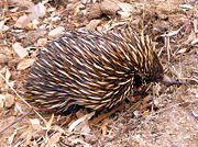
The concept plan identified 145 species of birds as either known or expected to be found in the park. By 2006, 98 species had been recorded in the park's area, though not all specifically within the park's boundaries. Of the park's insects, seven species were found to be largely confined by its boundaries, with little presence is the rest of Adelaide. Their presence was unusual, as they were regarded as arid zone species. Approximately 35 reptile and amphibian species have been recorded within Anstey Hill park. Fauna in the park includes Western Grey Kangaroo
, Common Ringtail Possum
, Common Brushtail Possum
, Short-beaked Echidna
, Gould's Wattled Bat
, Chocolate Wattled Bat
, Little Forest Bat
, White-striped Free-tailed Bat
and the Lesser Long-eared Bat
. Koala
s are present, though they are not native to the area, having been deliberately introduced to the Adelaide hills.
Foreign animals are also found, in common with much of Adelaide. While Red Fox
es, cats, European Rabbit
s, Black Rat
s, House Mice
and European Hare
s are seen, there has been no systemic recording of alien fauna species. Exotic birds, including Rock Pigeon
s, European goldfinch, house sparrow, starlings and blackbirds are common. Introduced bees and European wasps are present, with the aggressive wasps an issue for the park's visitors.
 The name of the park derives from a road built by George Alexander Anstey
, a South Australian pastoral and horticultural pioneer. Anstey established Highercombe Estate on two land sections east of the park that he purchased in 1840. He built a private road to his estate, which ran along the base of a gully and up a steep hillside. The road was initially named "Anstey Hill Road"; this name was later used for the hill, the subsequent land reserve and the current recreation park.
The Gun Emplacement was officially named as such in 1997 after a period of unofficial usage. This name was first used by Major William Hubert Edmunds, a Lieutenant cartographer
in the Boer War
who later enlisted in the Commonwealth of Australia forces. After leaving the military, Edmunds carried out "reconnaissance surveys" on the fringes of the Adelaide metropolitan area. As part of the work, he took particular note of an unusual plateau at the edge of what is now Tea Tree Gully. By the time his work was published in 1926, he had named the plateau "The Gun Emplacement", presumably for its suitability as a location for a field gun
battery.
One notable purchase was of 73 hectares (180.4 acre) in 1969, of which 16 hectares (39.5 acre) was an active quarry operated by Quarry Industries. This quarry was known as the Tea Tree Gully freestone quarry and today lies in the park's northwest. It had a permit to operate until December 1970, which was later extended to December 1980. Additional land affected by the quarrying was purchased in 1971. By the end of the lease, rehabilitation work completed did not meet the standard required by the Planning Authority. Quarry Industries vacated the site in April 1982, other firms then contracted to continue rehabilitation work. Land beneath the Gun Emplacement was subdivided
for housing in 1966. A developer unsuccessfully attempted to have the plateau subdivided in 1975. The site was purchased by the government in 1978 and added to the then Anstey Hill Reserve. During the 1970s, part of the park's area was earmarked to be subdivided and developed for housing. Significant opposition to this use, due to the land's historical and scientific significance, came from the South Australian division of the Geological Society of Australia
, the National Trust
and the state's Field Naturalists Society.
The Planning Authority established the Anstey Hill Joint Steering Committee in 1981, initially to prepare a concept plan for development of the reserve. The draft report was published in late 1981 with a proposal to spend up to $3.5 million establishing the park. Uses were explored including: a rock climbing area, motocross circuit, kiosk, cycle track, horse riding area, caravan and camping grounds and a restaurant. In 1983, the state Department of Environment and Planning published the final concept plan for the "Anstey Hill Regional Park". The plan indicated that a caravan park, or possibly a velodrome
, might be an appropriate development. There was significant interest by developers to use parts of the park commercially. Increasing public opposition to this concept led to the declaration of the entire reserve as a public recreation park. The Friends of Anstey Hill Recreation Park volunteer group was formed in 1990. Most of the then 306.5 ha (757.4 acre) park was proclaimed on 31 August 1989 with a smaller 55.5 hectares (137.1 acre) addition in October 2001. It was officially opened by Environment and Planning Minister Susan Lenehan
in a ceremony on 17 September 1989. The Department for Environment and Heritage added one last section to the park in 2003. A wedge of land 15 by remained from a purchase by George Dickerson in 1857. This land formed part of a cliff and had long been managed as part of the park. No known current owner was found and the Department compulsorily acquired the land and added it to the Recreation Park.
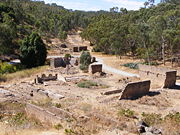 The remains of Newman's Nursery, established by Charles Newman and his family in the second half of the 19th century, are situated within the park at the base of Water Gully. After living on a rural property near Houghton
, he bought 68 acres (27.5 ha) of unfenced land in 1854. This land encompassed what became known as Water Gully, a gully
with a creek and permanent springs
. The first house, a simple slab hut set into a hill bank, was built on the property by 1855. The Newmans added more land from 1866; at its largest the property covered 469 acres (189.8 ha) and had a land tax valuation of GBP£7850
(A$
1.64 million in 2005) by 1885. From 1854 onwards, the initially heavily wooded land was continuously cleared, planted and developed.
The Newmans developed a nursery on the site between 1857 and 1871, over time assisted by their 17 children. There were hothouses in operation by 1870, and produce from the site was shown in exhibits from 1871. At maximum extent in the late 19th century it had its own dairy
and large numbers of glasshouses
and hothouses. At the time it was the largest nursery in the southern hemisphere
. Newman renamed it in 1875 to 'Newman's Model Nursery', probably for promotional purposes. In 1889 plant stocks included over 100,000 orange trees, the same number of mostly muscatel
grape vines and 500,000 other fruit trees. It grew 300 varieties of orchids, 350 of chrysanthemum
s and 700 of rose
s. The nursery was a frequent prize winner at agricultural fairs and exhibitions. At the Great Exhibition for the Queen’s Jubilee in 1887, the Newmans won two "First Orders of Merit", the exhibition's highest award, and all three "Exhibition Diplomas" on offer. Charles Newman died in 1889 after falling from his horse, and control of the nursery passed to his sixth son, Frederick.
During a severe storm in February 1913, 2 inches (5.1 cm) of rain fell in an hour, setting the streams, creeks and roads awash and damaging the nursery. In October of the same year, another storm destroyed buildings and plantings. Due to the extent of the destruction, and the lack of funds for full repairs, the nursery never fully recovered. Frederick Newman left the nursery in 1925 to run a smaller one in Tea Tree Gully, next to North East Road; control of the original nursery passed to Harry Newman. With the death of Charles' wife Mary Ann in 1932, the property was sold and subsequently used as a dairy. It changed ownership again in 1935, then used for sheep grazing. The new owner removed everything of value from the property; slate
paving and benches were sold, buildings were stripped to walls and foundations, pine trees lining the entrance road were turned to box wood and some outbuildings were knocked down. Most remaining plants and fruit trees from the property's nursery days were destroyed by bushfires during Ash Wednesday
in 1983. The ruins of Newman’s Nursery consist largely of foundations and walls and are listed on the State Heritage Register.
, sandstone and quartzite rock have been extensively mined in the park. Though traces of silver, copper and gold are present, there have been no economic finds. The park is scattered with many quarries
; the largest within the park is an open-cut
in the northwest corner. It was in operation until 1982 supplying stone for buildings, including Adelaide's war memorial and St Peter's Cathedral
. Tea Tree Gully Freestone from some quarries has been used for the facades and ornamental dressing of many of Adelaide’s Victorian public buildings. Adelaide Town Hall, the General Post Office and Supreme Court Buildings in Adelaide were all built entirely of this stone. The quarries supplied dressing stock for ornamentation on buildings, including St Peter's Cathedral
, St Francis Xavier's Cathedral, Flinders Street Baptist Church and the University of Adelaide
's Mitchell Building.
An ironstone
mine was opened to work on a rock outcrop in 1853. The mine was to supply flux
for the Port Adelaide
copper smelting
works, but it apparently closed within a year. It was reopened in 1861 and operated until 1862. The Tea Tree Gully Silver Mining Company began work in the area in 1888, constructing a tramway, blacksmith
shop and a new road. With no economic finds, the company closed in July 1889. The quarry, in Water Gully adjacent to the nursery's ruins, has been mined for blue dolomite, some of which was used for the nursery's buildings. Quarries elsewhere in Water Gully were opened in the 1880s and intermittently supplied quartzite road metal for the District Council of Tea Tree Gully. A crushing plant was erected on the north side of the gully in 1912 to create this road material.
When the park was proclaimed, land zoning regulations allowed existing mining prospecting rights to continue. These rights were restricted to previously mined areas; this coupled with further restrictions imposed by the National Parks and Wildlife Service Act (1972) make it unlikely that mining will occur in the future.
 Klopper's quarries, in the park's south, were mined in the late 19th and early 20th centuries. They were established by Heinrich Kloepper—later anglicised
to Henry Klopper—who arrived at Adelaide in 1847 from Hamburg
, Germany
. He purchased land in Hope Valley and a section below Anstey Hill. On the Anstey Hill section he opened his first quarry in 1850. The Klopper quarries supplied aggregate for road building and Bluestone for home and road kerbs
. After Klopper's death in 1888 his wife and sons continued the quarries operation. Stone from the first quarry was used to build a family home, on the south east corner of nearby Valley and Grand Junction
roads. Additional quarries were opened and supplied metal for most of the roads constructed in Highercombe. In 1905 the family opened a freestone quarry within the park that operated until its 1927 sale.
The freestone quarry was used to host plays
as part of the Adelaide Festival of Arts
. It seated about 800 people and its 20 m (65.6 ft) face provided a backdrop to the performances. Three plays were performed over fifteen nights in the 1980 festival. A nine-hour production of the Mahābhārata
, by the theatre company of Peter Brook
, was performed in 1988.
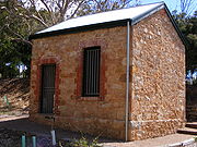 The historic Ellis Cottage and Rumps Bakery buildings lie near the corner of Perseverance and North East roads. Built in 1854, Ellis Cottage is a single room stone building built by John Stevens, founder of Steventon Estate that later become the suburb of Tea Tree Gully. It was named after the Ellis family, who owned and used the building for storage for many years until World War II
. Rumps Bakery was built in 1854 with local stone. From 1867 to 1893 it was rented to Charles Rumps, who started Tea Tree Gully's first bakery in the building in 1872. In 1894, the building was sold to Ernest Heitmann, who continued to use it as a bakery. Until the mid-20th century, the Ellis family and an adjacent general store frequently used it for storage. Assisted by a government grant and supervised by the Department of Environment and Heritage, the Friends of Anstey Hill stabilised both buildings in 2000.
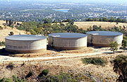 In the 1970s, the Engineering and Water Supply Department chose an area at the top of the park, adjacent to Lower North East Road, to build a water treatment works. Based partly on seismic refraction traverses, a ridge underlain by dolomite and quartzite was deemed to be stable enough for construction. The site was also selected because of its hydraulic advantages; all other sites would have required the construction of a major pumping station. The exact placement of the site was made so that it could not be seen from the metropolitan area. It has a design flow of 313 megalitres (ML) per day with a maximum capacity of 344 ML. The plant was commissioned in 1980 and uses filtration and sedimentation techniques to clean water from the Mannum to Adelaide pipeline. It was the second plant in Adelaide, after the opening of the Hope Valley plant in 1977. Most of the water is piped directly from the River Murray, but some is sourced from Millbrook Reservoir
.
The plant was intended to serve 70,000 homes in the outer northeastern suburbs of Adelaide, specifically those north of the River Torrens
. The total construction cost was $14.5 million, including changes to the existing pipeline. As of 2005, the plant filters approximately 20% of Adelaide's water supply. A small hydroelectric
plant began operating in adjacent Hope Valley in 2003, using the head of water as it flows down Anstey Hill. The plant is designed to supply 7,000 megawatt hours per year.
in 1930. It now separates a small part of the park—that contains Klopper's quarries and the Gun Emplacement—from the rest. Remains of the two previous roads can be seen near Klopper's quarries.
Perseverance Road, and some housing, defines the western edge of much of the park. William Haines was the district clerk for Tea Tree Gully from 1867 to 1902 and Member of Parliament for Gumeracha from 1878 to 1884. Since 1862, he had lobbied for construction of a road to link Tea Tree Gully to Anstey Hill Road. The 1–½ mile road was eventually approved and subsequently opened in 1880. Known as Haines' Folly before its completion, it was officially called Haines' Perseverance Road at the opening ceremony.
Adelaide
Adelaide is the capital city of South Australia and the fifth-largest city in Australia. Adelaide has an estimated population of more than 1.2 million...
, South Australia
South Australia
South Australia is a state of Australia in the southern central part of the country. It covers some of the most arid parts of the continent; with a total land area of , it is the fourth largest of Australia's six states and two territories.South Australia shares borders with all of the mainland...
. It is managed by the City of Tea Tree Gully
City of Tea Tree Gully
The City of Tea Tree Gully is in the Australian state of South Australia, in the outer north-eastern suburbs of Adelaide. The city has a estimated population of 100,155 people and is one of the most populous local government divisions in Adelaide...
, the Department for Environment and Heritage
Department for Environment and Heritage
The Department for Environment and Natural Resources is a department of the Government of South Australia . It is responsible for protecting, conserving and managing South Australia's natural environment, and cultural heritage.-External links:* Government of South Australia...
and a volunteer group—The Friends of Anstey Hill
Friends of Parks
Friends of Parks Incorporated is an umbrella organisation for 141 individual volunteer community groups and over 7000 individual volunteers in South Australia, who are each affiliated with a specific national park or historic site...
. The park is designed for recreational walking and there are no visitor facilities. It is part of Yurrebilla, the Greater Mount Lofty Parklands, and is a significant reserve of bushland
The Bush
"The bush" is a term used for rural, undeveloped land or country areas in certain countries.-Australia:The term is iconic in Australia. In reference to the landscape, "bush" describes a wooded area, intermediate between a shrubland and a forest, generally of dry and nitrogen-poor soil, mostly...
in the foothills of the Mount Lofty Ranges
Mount Lofty Ranges
The Mount Lofty Ranges are the range of mountains just to the east of Adelaide in South Australia.-Location and description:The Mount Lofty Ranges stretch from the southernmost point of the Fleurieu Peninsula at Cape Jervis northwards for over before petering out north of Peterborough...
. Anstey Hill Recreation Park is home to rare or vulnerable native plants and animals, and problematic invasive species.
The park's land was gradually acquired by the Government of South Australia
Government of South Australia
The form of the Government of South Australia is prescribed in its constitution, which dates from 1856, although it has been amended many times since then...
beginning in 1966, based on recommendations in a 1962 report. From 1981 onwards, plans were published that aimed to develop the area for commercial purposes, but public pressure led to its declaration as a public reserve in 1989. The last land added was a small area in 2003. Anstey Hill is a 371 metres (1,217.2 ft) high peak in the park's south. Both hill and park are named after a road built by agricultural pioneer George Alexander Anstey
George Alexander Anstey
George Alexander Anstey was born at Kentish Town, London. He was the eldest son on Thomas Anstey, an early settler in Van Diemen's Land . George migrated to Tasmania at the age of thirteen and arrived in Hobart in February 1827 with Thomas 'Chiz' Chisholm Anstey, one of his younger brothers, in...
. Fire authorities regard the park as an "arson
Arson
Arson is the crime of intentionally or maliciously setting fire to structures or wildland areas. It may be distinguished from other causes such as spontaneous combustion and natural wildfires...
hotspot", and it is frequently burned by bushfires—mostly deliberately lit. There is no permanent water except for springs
Spring (hydrosphere)
A spring—also known as a rising or resurgence—is a component of the hydrosphere. Specifically, it is any natural situation where water flows to the surface of the earth from underground...
in Water Gully, adjacent to ruins of a nursery
Nursery (horticulture)
A nursery is a place where plants are propagated and grown to usable size. They include retail nurseries which sell to the general public, wholesale nurseries which sell only to businesses such as other nurseries and to commercial gardeners, and private nurseries which supply the needs of...
, although there are many seasonal creeks. Much of the land is steep, rising 200 m (656.2 ft) across the park's breadth, with gradients often steeper than one in three. Erosion and land movements due to a significant geologic fault zone created this land form. The Gun Emplacement, a listed Geologic Monument and remnant of an ancient land surface, lies in the southwestern corner.
The Adelaide–Mannum
Mannum, South Australia
Mannum is an historic town on the west bank of the Murray River in South Australia, east of Adelaide. At the 2006 census, Mannum had a population of 2,042. Mannum headquarters the Mid Murray Council, and is situated in both the State Electoral District of Schubert and the federal Division of...
pipeline crosses the park and the Anstey Hill water filtration
Water purification
Water purification is the process of removing undesirable chemicals, materials, and biological contaminants from contaminated water. The goal is to produce water fit for a specific purpose...
plant lies on its southern boundary; together they supply 20% of Adelaide's reticulated water. Significant historical uses of the area are preserved as ruins and highlighted with interpretive signs. The ruins of Newman's Nursery are all that remains of what was once the largest plant nursery in the Southern Hemisphere. Ellis Cottage is one of the earliest homes in the area, and the Rumps Bakery building housed the first bakery in Tea Tree Gully
Tea Tree Gully, South Australia
Tea Tree Gully is a suburb in the greater Adelaide, South Australia area, under the City of Tea Tree Gully. Tea Tree Gully is in the City of Tea Tree Gully local government area, the South Australian House of Assembly electoral district of Newland and the Australian House of Representatives...
. Quarries supplied stone for significant Victorian
Victorian architecture
The term Victorian architecture refers collectively to several architectural styles employed predominantly during the middle and late 19th century. The period that it indicates may slightly overlap the actual reign, 20 June 1837 – 22 January 1901, of Queen Victoria. This represents the British and...
buildings in Adelaide and aggregate
Construction Aggregate
Construction aggregate, or simply "aggregate", is a broad category of coarse particulate material used in construction, including sand, gravel, crushed stone, slag, recycled concrete and geosynthetic aggregates. Aggregates are the most mined material in the world...
for road building. Klopper's quarries in the southwest hosted plays for the Festival of the Arts
Festival of the Arts
The Festival of the Arts, or simply Festival is a three day arts festival in Grand Rapids held on the first Friday, Saturday, and Sunday of June. First held in 1970, after the 1969 installation of Alexander Calder's La Grande Vitesse, known as "The Calder" locally, Festival was quite small with...
in 1980 and 1988.
Today's park
Mount Lofty Ranges
The Mount Lofty Ranges are the range of mountains just to the east of Adelaide in South Australia.-Location and description:The Mount Lofty Ranges stretch from the southernmost point of the Fleurieu Peninsula at Cape Jervis northwards for over before petering out north of Peterborough...
' foothills and forms part of the "hill's face" that is visible from Adelaide's metropolitan area. The park covers 362 hectares (894.5 acre) of the City of Tea Tree Gully, approximately 19 km (11.8 mi) northeast of Adelaide's central business district
Central business district
A central business district is the commercial and often geographic heart of a city. In North America this part of a city is commonly referred to as "downtown" or "city center"...
, with parts in the suburbs of Tea Tree Gully
Tea Tree Gully, South Australia
Tea Tree Gully is a suburb in the greater Adelaide, South Australia area, under the City of Tea Tree Gully. Tea Tree Gully is in the City of Tea Tree Gully local government area, the South Australian House of Assembly electoral district of Newland and the Australian House of Representatives...
, Vista
Vista, South Australia
Vista is a small north-eastern suburb of Adelaide, South Australia and is within the City of Tea Tree Gully local government area. It is adjacent to Houghton, Tea Tree Gully, St Agnes and Hope Valley.-History:...
, Highbury
Highbury, South Australia
Highbury is a suburb of Adelaide, located within the City of Tea Tree Gully. It is adjacent the suburbs of Hope Valley and Dernancourt. Local services include pubs, supermarkets and a post office.-References:...
and Houghton
Houghton, South Australia
Houghton is a small town near Adelaide, South Australia. It is located in the Adelaide Hills, in the City of Tea Tree Gully and the Adelaide Hills Council local government areas between Tea Tree Gully and Inglewood on the North East Road.-History:...
. The Adelaide–Mannum water supply pipeline crosses the park's south, and an associated filtration plant is sited on its southern boundary. Adjacent to the water filtration plant is Anstey Hill, reaching 371.1 m (1,217.5 ft) above mean sea level
Above mean sea level
The term above mean sea level refers to the elevation or altitude of any object, relative to the average sea level datum. AMSL is used extensively in radio by engineers to determine the coverage area a station will be able to reach...
. The hill is 50 m (164 ft) shorter than a nearby unnamed peak. The park’s southern boundary abuts the Anstey Hill Quarry, a producer of white clay, and two large disused quarries.
The park is part of the Greater Mount Lofty Parklands, an area also known as Yurrebilla. Management of the park is influenced by the Department for Environment and Heritage's long term biodiversity goals for the hill face zone. The Department manages the park in association with local council and a volunteer group—The Friends of Anstey Hill. This volunteer group makes significant contributions to revegetation
Revegetation
Revegetation is the process of replanting and rebuilding the soil of disturbed land. This may be a natural process produced by plant colonization and succession, or an artificial , accelerated process designed to repair damage to a landscape due to wildfire, mining, flood, or other cause...
, weed control, ruin stabilisation and creation of walking trails. There are no visitor facilities or amenities except for walking trails, most of which follow fire access tracks; a single constructed pedestrian trail leads to Klopper’s Quarry. The park is mostly designated as a "conservation zone" where only passive recreation, including walking dogs on leads, is permitted. Horses and motor vehicles are not allowed and only the main tracks are maintained.
In recognition of the established and popular activity of mountain biking in the greater Adelaide area, and to better accommodate the mountain biking community in the North Eastern suburbs, the Department for Environment and Heritage has proposed to permit cycling in designated zones on purpose-built tracks and on certain management tracks within the park. The intention is to satisfy both biodiversity and recreation objectives in the park and reducing the incidence of illegal mountain bike riding in other non designated areas.
Anstey Hill Park lies between Bureau of Meteorology measured rainfall contour lines that denote an annual average from 580 to 820 mm (22.8 to 32.3 in). It has hot dry summers, as does all of Adelaide, and December to February's average maximum daily temperatures 28 °C (82 °F) to 29 °C (84 °F). Temperatures drop significantly in the wetter winters; July's average maximum temperature is 14.6 °C (58.3 °F). Apart from springs in Water Gully, the site of Newman's Nursery ruins, all of the numerous creeks in the park are seasonal and dry for much of the year. The park rises from approximately 220 m (721.8 ft) above mean sea level on its western side to 420 m (1,378 ft) at the highest point in the park's southeast corner. Most of the park is steeply sloping with gradients steeper than one in four. Except for the base of Water Gully, topsoil throughout the park is shallow and low in plant nutrients.
There are frequent serious bushfires in the park. Much of the reserve was burned in 1980, eastern parts burned in 1981, and most of the park burned again in the 1983 Ash Wednesday fires
Ash Wednesday fires
The Ash Wednesday bushfires, known in South Australia as Ash Wednesday II, were a series of bushfires that occurred in south-eastern Australia on 16 February 1983. Within twelve hours, more than 180 fires fanned by winds of up to 110 km per hour caused widespread destruction across the states...
; Newman's Nursery's remains were devastated during the 1983 bushfire. As recently as 2004, a major fire burned over 100 ha (247 acre) of bushland next to Anstey Hill. Most fires in the park are deliberately lit and the park is regarded as a "hotspot" for arson
Arson
Arson is the crime of intentionally or maliciously setting fire to structures or wildland areas. It may be distinguished from other causes such as spontaneous combustion and natural wildfires...
. Arson in the park is not a recent phenomenon; an early record comes from an 1869 coronial
Coroner
A coroner is a government official who* Investigates human deaths* Determines cause of death* Issues death certificates* Maintains death records* Responds to deaths in mass disasters* Identifies unknown dead* Other functions depending on local laws...
inquiry. The park has more than one arson attack, on average, each year. In the hill's face, encompassing Anstey Hill, approximately 60% of all fires (1999–2004) are deliberately lit and less than 5% are classed as naturally occurring. Most deliberately lit fires begin at the park's boundaries and are contained within it.
Geology
Elevation rise across the park results from land uplift along the Burnside-Eden fault zone. This zone is a major land fault separating the Adelaide PlainsAdelaide Plains
The Adelaide Plains is the area in South Australia between the Mount Lofty Ranges on the east and Gulf St Vincent on the west. The plains are generally fertile with annual rainfall of about per year....
from the Mount Lofty Ranges and runs north-north-east across the park from its southwest corner. The park is underlain by neoproterozoic
Neoproterozoic
The Neoproterozoic Era is the unit of geologic time from 1,000 to 542.0 ± 1.0 million years ago. The terminal Era of the formal Proterozoic Eon , it is further subdivided into the Tonian, Cryogenian, and Ediacaran Periods...
sedimentary rock
Sedimentary rock
Sedimentary rock are types of rock that are formed by the deposition of material at the Earth's surface and within bodies of water. Sedimentation is the collective name for processes that cause mineral and/or organic particles to settle and accumulate or minerals to precipitate from a solution....
s of the Burra Group overlying a Precambrian
Precambrian
The Precambrian is the name which describes the large span of time in Earth's history before the current Phanerozoic Eon, and is a Supereon divided into several eons of the geologic time scale...
crystalline basement. Sediments were formed approximately 700 million years ago (mya) from sand washed into a shallow sea. Sand layers were then folded and slightly metamorphosed
Metamorphic rock
Metamorphic rock is the transformation of an existing rock type, the protolith, in a process called metamorphism, which means "change in form". The protolith is subjected to heat and pressure causing profound physical and/or chemical change...
during the delamerian orogeny
Orogeny
Orogeny refers to forces and events leading to a severe structural deformation of the Earth's crust due to the engagement of tectonic plates. Response to such engagement results in the formation of long tracts of highly deformed rock called orogens or orogenic belts...
, a period of mountain building caused by tectonic plate
Plate tectonics
Plate tectonics is a scientific theory that describes the large scale motions of Earth's lithosphere...
movements and resulting east-west compression of Australia. This pushed up a mountain range, on the site of the present Mount Lofty Ranges, approximately 450 mya. The range was eroded to a level plain over the following 350 million years. Approximately 40 mya, the location of today's ranges and plains were flat, with a hard sedimentary capping. About 2 mya, block faulting
Fault-block mountain
Fault-block landforms are formed when large areas of bedrock are widely broken up by faults creating large vertical displacements of continental crust....
raised the Mount Lofty Ranges, and much of the former land surface west of the ranges eroded away. The Gun Emplacement is a small remnant of this pre-erosion surface. It is a raised semi-circular flat area and has views over much of Adelaide from the southwestern corner of the park. The Emplacement is seen as an important regolith
Regolith
Regolith is a layer of loose, heterogeneous material covering solid rock. It includes dust, soil, broken rock, and other related materials and is present on Earth, the Moon, some asteroids, and other terrestrial planets and moons.-Etymology:...
deposit, particularly for its role in understanding Adelaide's landscape's evolution. The Emplacement was declared a Geological Monument in 1978 for this geologic importance as well as its aesthetic and recreational value.
Across the park, different ages of exposed rocks are seen. Stoneyfell quartzite
Quartzite
Quartzite is a hard metamorphic rock which was originally sandstone. Sandstone is converted into quartzite through heating and pressure usually related to tectonic compression within orogenic belts. Pure quartzite is usually white to gray, though quartzites often occur in various shades of pink...
, composed mostly of quartzite with sandstone
Sandstone
Sandstone is a sedimentary rock composed mainly of sand-sized minerals or rock grains.Most sandstone is composed of quartz and/or feldspar because these are the most common minerals in the Earth's crust. Like sand, sandstone may be any colour, but the most common colours are tan, brown, yellow,...
and some siltstone
Siltstone
Siltstone is a sedimentary rock which has a grain size in the silt range, finer than sandstone and coarser than claystones.- Description :As its name implies, it is primarily composed of silt sized particles, defined as grains 1/16 - 1/256 mm or 4 to 8 on the Krumbein phi scale...
, is the youngest. Woolshed flat shale
Shale
Shale is a fine-grained, clastic sedimentary rock composed of mud that is a mix of flakes of clay minerals and tiny fragments of other minerals, especially quartz and calcite. The ratio of clay to other minerals is variable. Shale is characterized by breaks along thin laminae or parallel layering...
is older and is composed of siltstone, dolomite
Dolomite
Dolomite is a carbonate mineral composed of calcium magnesium carbonate CaMg2. The term is also used to describe the sedimentary carbonate rock dolostone....
and some sandstone. The oldest regular exposure is Montacute dolomite, which is a blue-grey dolomite with magnesite
Magnesite
Magnesite is magnesium carbonate, MgCO3. Iron substitutes for magnesium with a complete solution series with siderite, FeCO3. Calcium, manganese, cobalt, and nickel may also occur in small amounts...
, siltstone and sandstone. Quarries in the south of the park have been mined for Stoneyfell Quartzite. This type of quartzite is a clean, white, feldspar
Feldspar
Feldspars are a group of rock-forming tectosilicate minerals which make up as much as 60% of the Earth's crust....
thic quartzite with interbedded thin siltstone layers up to 30 cm (11.8 in) thick occurring at gaps of 1–2 m (3.3–6.6 ). Ripple marks in this rock clearly indicate its shallow water origin. Next to Newman's Nursery is a quarry with grey to blue silicaceous dolomite used for road material. It contains traces of pyrite
Pyrite
The mineral pyrite, or iron pyrite, is an iron sulfide with the formula FeS2. This mineral's metallic luster and pale-to-normal, brass-yellow hue have earned it the nickname fool's gold because of its resemblance to gold...
and is overlain by phyllite
Phyllite
Phyllite is a type of foliated metamorphic rock primarily composed of quartz, sericite mica, and chlorite; the rock represents a gradation in the degree of metamorphism between slate and mica schist. Minute crystals of graphite, sericite, or chlorite impart a silky, sometimes golden sheen to the...
. Tea Tree Gully freestone, as found in the largest quarry in the park, is a feldsparthic sandstone bedded with quartzite. Decay of the feldspar has enabled it to be cut and dressed as a quality building stone. The Tea Tree Gully iron (or silver) mine lies in an iron-rich fault zone. The ore body is ironstone
Ironstone
Ironstone is a sedimentary rock, either deposited directly as a ferruginous sediment or created by chemical repacement, that contains a substantial proportion of an iron compound from which iron either can be or once was smelted commercially. This term is customarily restricted to hard coarsely...
, 150 m long, 50 m wide and 30 m thick (490 ft by 160 ft by 100 ft). It is primarily limonite
Limonite
Limonite is an ore consisting in a mixture of hydrated iron oxide-hydroxide of varying composition. The generic formula is frequently written as FeO·nH2O, although this is not entirely accurate as limonite often contains a varying amount of oxide compared to hydroxide.Together with hematite, it has...
, detrital quartz and silica. It is thought to have been chemically deposited during the Tertiary period, 2 mya to 65 mya.
Flora and fauna
Prasophyllum
Prasophyllum is a genus in the orchid family . Species of this genus are commonly called "Leek Orchids". There is no designated type species. Prasophyllum australe R.Br...
). The park has significant stands of Pink Gums (Eucalyptus fasciculosa) and Long-leafed Box (Eucalyptus goniocalyx
Eucalyptus goniocalyx
Eucalyptus goniocalyx, Long-leaved box is a small to medium-sized tree with rough and persistent bark to the small branches. It is fibrous, greyish, becoming deeply fissured, thick and shaggy in larger trees...
). Button Daisy, Pussy Tail (Ptilotus macrocephalus
Ptilotus macrocephalus
Ptilotus macrocephalus is a native Australian perennial herb growing up to high. It is found across all Australian mainland states, mainly in the drier inland areas. P. macrocephalus has green to white ovoid flower heads....
), Needlebush (Hakea sericea
Hakea sericea
Hakea sericea, commonly known as Needlebush or Silky Hakea, is a large species of shrub native to Australia. It is native to New South Wales, Victoria and Tasmania but is found outside these states. It grows up to as a spreading and bushy shrub, flowering from winter to early spring.H...
), Silky Guinea Flower (Hibbertia sericea
Hibbertia sericea
Hibbertia sericea, or Silky Guinea-flower, is a species of small perennial shrub, in the family Dilleniaceae, that is endemic to Australia. It has small yellow five-petalled flowers to across....
) and Black Fapier Sedge (Lepidosperma calihoides) are common. Black-boys (Xanthorrhoea
Xanthorrhoea
Xanthorrhoea is a genus of flowering plants native to Australia and a member of family Xanthorrhoeaceae, being the only member of subfamily Xanthorrhoeoideae. The Xanthorrhoeaceae are monocots, part of order Asparagales. There are 28 species and five subspecies of Xanthorrhoea.-Description:All are...
), Hop Bush (Dodonaea viscosa
Dodonaea viscosa
Dodonaea viscosa is a species of flowering plant in the soapberry family, Sapindaceae, that has a cosmopolitan distribution in tropical, subtropical and warm temperate regions of Africa, the Americas, southern Asia and Australasia.-Description:...
ssp. spatulata) and Tea-tree
Melaleuca
Melaleuca is a genus of plants in the myrtle family Myrtaceae known for its natural soothing and cleansing properties. There are well over 200 recognised species, most of which are endemic to Australia...
form the understory
Understory
Understory is the term for the area of a forest which grows at the lowest height level below the forest canopy. Plants in the understory consist of a mixture of seedlings and saplings of canopy trees together with understory shrubs and herbs...
in parts of the park. The area around the ruins of Newman's Nursery is noted for its spring orchid display. Quarry floors have large plants typical of much of the Mount Lofty Ranges. Golden Wattle (Acacia pycnantha) and Drooping Sheoak (Allocasuarina
Allocasuarina
Allocasuarina is a genus of trees in the flowering plant family Casuarinaceae. They are endemic to Australia, occurring primarily in the south. Like the closely related genus Casuarina, they are commonly called sheoaks or she-oaks, they are notable for their long, segmented branchlets that...
verticillata), as well as Red Gums (Eucalyptus camaldulensis), Native Pine (Callitris preissii
Callitris preissii
Callitris preissii is a species of conifer in the Cupressaceae family, found only in Australia.Common Names: Rottnest Island pine , Murray pine, maroong, Southern Cypress pine, or Slender Cypress pine -External Links:...
) and Blue Gum (Eucalyptus leucoxylon
Eucalyptus leucoxylon
Eucalyptus leucoxylon, commonly known as the Yellow Gum, Blue Gum or White Ironbark, is a small to medium-sized tree with rough bark on the lower 1-2 metres of the trunk, above this, the bark becomes smooth with a white, yellow or bluish-grey surface...
) are common.
Invasive weeds are prevalent in, and damaging to, the park. Species common in other formerly occupied parts of the foothills are also common in the park. Of significant concern, largely for their impact on native flora, are Bridal Creeper (Asparagus asparagoides
Asparagus asparagoides
Asparagus asparagoides, commonly known as Bridal creeper, Bridal-veil creeper, Gnarboola, Smilax or Smilax asparagus, is a herbaceous climbing plant of the family Asparagaceae native to tropical and southern Africa...
), Boneseed (Chrysanthemoides monilifera
Chrysanthemoides monilifera
Chrysanthemoides monilifera...
), Artichoke Thistle
Cardoon
The cardoon , also called the artichoke thistle, cardone, cardoni, carduni or cardi, is a thistle-like plant in the aster family Asteraceae. It is the naturally occurring form of the same species as the globe artichoke, and has many cultivated varieties...
(Cynara cardunculus), varieties of broom
Broom (shrub)
Brooms are a group of evergreen, semi-evergreen, and deciduous shrubs in the subfamily Faboideae of the legume family Fabaceae, mainly in the three genera Chamaecytisus, Cytisus and Genista, but also in many other small genera . All genera in this group are from the tribe Genisteae...
, Spanish Heath (Erica lusitanica
Erica lusitanica
Erica lusitanica is a species of flowering plant in the heather family known by the common names Spanish heath and Portuguese heath. It is native to southwestern Europe and it is present in other regions of the world as an introduced species and sometimes a noxious weed. It is naturalized in...
), Fennel
Fennel
Fennel is a plant species in the genus Foeniculum . It is a member of the family Apiaceae . It is a hardy, perennial, umbelliferous herb, with yellow flowers and feathery leaves...
(Foeniculum vulgare) , Olive
Olive
The olive , Olea europaea), is a species of a small tree in the family Oleaceae, native to the coastal areas of the eastern Mediterranean Basin as well as northern Iran at the south end of the Caspian Sea.Its fruit, also called the olive, is of major agricultural importance in the...
s, blackberries
Rubus
Rubus is a large genus of flowering plants in the rose family, Rosaceae, subfamily Rosoideae. Raspberries, blackberries, and dewberries are common, widely distributed members of the genus. Most of these plants have woody stems with prickles like roses; spines, bristles, and gland-tipped hairs are...
, Common Gorse
Common Gorse
Ulex europaeus, gorse, common gorse, furze or whin is an evergreen shrub in the family Fabaceae, native to western Europe from the northerly point of the United Kingdom south to Portugal, and from the westerly point of the Republic of Ireland east to Galicia in Poland and Ukraine.-Description:It...
(Ulex europaeus) and Dog Rose (Rosa canina). In July 2001, Phytophthora cinnamomi
Phytophthora cinnamomi
Phytophthora cinnamomi is a soil-borne water mould that produces an infection which causes a condition in plants called root rot or dieback. The plant pathogen is one of the world's most invasive species and is present in over 70 countries from around the world.- Life cycle and effects on plants :P...
, a significant cause of plant disease in the Adelaide Hills, was found in the park. Mechanical countermeasures, in the form of boot scrubbing stations, have been introduced to control its spread.
The concept plan identified 145 species of birds as either known or expected to be found in the park. By 2006, 98 species had been recorded in the park's area, though not all specifically within the park's boundaries. Of the park's insects, seven species were found to be largely confined by its boundaries, with little presence is the rest of Adelaide. Their presence was unusual, as they were regarded as arid zone species. Approximately 35 reptile and amphibian species have been recorded within Anstey Hill park. Fauna in the park includes Western Grey Kangaroo
Western Grey Kangaroo
The Western Grey Kangaroo is a large and very common kangaroo or macropod, found across almost the entire southern part of Australia, from just south of Shark Bay to coastal South Australia, western Victoria, and the entire Murray-Darling Basin in New South Wales and Queensland...
, Common Ringtail Possum
Common Ringtail Possum
The common ringtail possum is an Australian marsupial. It lives in a variety of habitats and eats a variety of leaves of both native and introduced plants, as well as flowers and fruits. These dietary factors have, over time, aided burgeoning introduced populations in New Zealand...
, Common Brushtail Possum
Common Brushtail Possum
The Common Brushtail Possum is a nocturnal, semi-arboreal marsupial of the family Phalangeridae, it is native to Australia, and the largest of the possums.Like most possums, the Common Brushtail is nocturnal...
, Short-beaked Echidna
Short-beaked Echidna
The short-beaked echidna , also known as the spiny anteater because of its diet of ants and termites, is one of four living species of echidna and the only member of the genus Tachyglossus...
, Gould's Wattled Bat
Gould's Wattled Bat
Gould's Wattled Bat is a species of Australian wattled bat named after the English naturalist John Gould.-Range:C. gouldii is known throughout mainland Australia as well as Tasmania, New Caledonia, and Norfolk Island.-Appearance:C...
, Chocolate Wattled Bat
Chocolate Wattled Bat
The Chocolate Wattled Bat is a species of vesper bat in the Vespertilionidae family.It is found only in Australia.-References:* Chiroptera Specialist Group 1996. . Downloaded on 19 July 2007....
, Little Forest Bat
Little Forest Bat
The Little Forest Bat is a species of vesper bat in the Vespertilionidae family.It is found only in South-eastern Australia including Tasmania....
, White-striped Free-tailed Bat
White-striped Free-tailed Bat
The White-striped Free-tailed Bat is a species of bat in the family Molossidae. It is found in Australia, Indonesia, and Papua New Guinea.-Source:* Chiroptera Specialist Group 1996. . Downloaded on 30 July 2007....
and the Lesser Long-eared Bat
Lesser Long-eared Bat
The Lesser Long-Eared Bat is a species of vesper bat in the Vespertilionidae family.It is found only in Australia.-Classification:...
. Koala
Koala
The koala is an arboreal herbivorous marsupial native to Australia, and the only extant representative of the family Phascolarctidae....
s are present, though they are not native to the area, having been deliberately introduced to the Adelaide hills.
Foreign animals are also found, in common with much of Adelaide. While Red Fox
Red Fox
The red fox is the largest of the true foxes, as well as being the most geographically spread member of the Carnivora, being distributed across the entire northern hemisphere from the Arctic Circle to North Africa, Central America, and the steppes of Asia...
es, cats, European Rabbit
European Rabbit
The European Rabbit or Common Rabbit is a species of rabbit native to south west Europe and north west Africa . It has been widely introduced elsewhere often with devastating effects on local biodiversity...
s, Black Rat
Black Rat
The black rat is a common long-tailed rodent of the genus Rattus in the subfamily Murinae . The species originated in tropical Asia and spread through the Near East in Roman times before reaching Europe by the 1st century and spreading with Europeans across the world.-Taxonomy:The black rat was...
s, House Mice
House mouse
The house mouse is a small rodent, a mouse, one of the most numerous species of the genus Mus.As a wild animal the house mouse mainly lives associated with humans, causing damage to crops and stored food....
and European Hare
European Hare
The European hare , also known as the brown hare, Eastern Jackrabbit and Eastern prairie hare, is a species of hare native to northern, central, and western Europe and western Asia. It is a mammal adapted to temperate open country. It is related to the similarly appearing rabbit, which is in the...
s are seen, there has been no systemic recording of alien fauna species. Exotic birds, including Rock Pigeon
Rock Pigeon
The Rock Dove or Rock Pigeon, is a member of the bird family Columbidae . In common usage, this bird is often simply referred to as the "pigeon"....
s, European goldfinch, house sparrow, starlings and blackbirds are common. Introduced bees and European wasps are present, with the aggressive wasps an issue for the park's visitors.
Naming
George Alexander Anstey
George Alexander Anstey was born at Kentish Town, London. He was the eldest son on Thomas Anstey, an early settler in Van Diemen's Land . George migrated to Tasmania at the age of thirteen and arrived in Hobart in February 1827 with Thomas 'Chiz' Chisholm Anstey, one of his younger brothers, in...
, a South Australian pastoral and horticultural pioneer. Anstey established Highercombe Estate on two land sections east of the park that he purchased in 1840. He built a private road to his estate, which ran along the base of a gully and up a steep hillside. The road was initially named "Anstey Hill Road"; this name was later used for the hill, the subsequent land reserve and the current recreation park.
The Gun Emplacement was officially named as such in 1997 after a period of unofficial usage. This name was first used by Major William Hubert Edmunds, a Lieutenant cartographer
Cartography
Cartography is the study and practice of making maps. Combining science, aesthetics, and technique, cartography builds on the premise that reality can be modeled in ways that communicate spatial information effectively.The fundamental problems of traditional cartography are to:*Set the map's...
in the Boer War
Boer War
The Boer Wars were two wars fought between the British Empire and the two independent Boer republics, the Oranje Vrijstaat and the Republiek van Transvaal ....
who later enlisted in the Commonwealth of Australia forces. After leaving the military, Edmunds carried out "reconnaissance surveys" on the fringes of the Adelaide metropolitan area. As part of the work, he took particular note of an unusual plateau at the edge of what is now Tea Tree Gully. By the time his work was published in 1926, he had named the plateau "The Gun Emplacement", presumably for its suitability as a location for a field gun
Field gun
A field gun is an artillery piece. Originally the term referred to smaller guns that could accompany a field army on the march and when in combat could be moved about the battlefield in response to changing circumstances, as to opposed guns installed in a fort, or to siege cannon or mortars which...
battery.
Foundation
In 1962, the South Australian Planning Authority's town planning committee released a report on the development of metropolitan Adelaide. The report, in part, recommended that a regional park be established north of Anstey Hill and southeast of Tea Tree Gully. The stated intention was preservation of the character of the face of the foothills, as visible from Adelaide’s suburbs. From 1966 to 1977, land was purchased under the auspices of the State Planning Authority, for what was then "reserve 13".One notable purchase was of 73 hectares (180.4 acre) in 1969, of which 16 hectares (39.5 acre) was an active quarry operated by Quarry Industries. This quarry was known as the Tea Tree Gully freestone quarry and today lies in the park's northwest. It had a permit to operate until December 1970, which was later extended to December 1980. Additional land affected by the quarrying was purchased in 1971. By the end of the lease, rehabilitation work completed did not meet the standard required by the Planning Authority. Quarry Industries vacated the site in April 1982, other firms then contracted to continue rehabilitation work. Land beneath the Gun Emplacement was subdivided
Subdivision (land)
Subdivision is the act of dividing land into pieces that are easier to sell or otherwise develop, usually via a plat. The former single piece as a whole is then known in the United States as a subdivision...
for housing in 1966. A developer unsuccessfully attempted to have the plateau subdivided in 1975. The site was purchased by the government in 1978 and added to the then Anstey Hill Reserve. During the 1970s, part of the park's area was earmarked to be subdivided and developed for housing. Significant opposition to this use, due to the land's historical and scientific significance, came from the South Australian division of the Geological Society of Australia
Geological Society of Australia
The Geological Society of Australia was established as a non-profit organisation in 1952 to promote, advance and support earth sciences in Australia...
, the National Trust
National Trust of Australia
The Australian Council of National Trusts is the peak body for community-based, non-government organisations committed to promoting and conserving Australia's indigenous, natural and historic heritage....
and the state's Field Naturalists Society.
The Planning Authority established the Anstey Hill Joint Steering Committee in 1981, initially to prepare a concept plan for development of the reserve. The draft report was published in late 1981 with a proposal to spend up to $3.5 million establishing the park. Uses were explored including: a rock climbing area, motocross circuit, kiosk, cycle track, horse riding area, caravan and camping grounds and a restaurant. In 1983, the state Department of Environment and Planning published the final concept plan for the "Anstey Hill Regional Park". The plan indicated that a caravan park, or possibly a velodrome
Velodrome
A velodrome is an arena for track cycling. Modern velodromes feature steeply banked oval tracks, consisting of two 180-degree circular bends connected by two straights...
, might be an appropriate development. There was significant interest by developers to use parts of the park commercially. Increasing public opposition to this concept led to the declaration of the entire reserve as a public recreation park. The Friends of Anstey Hill Recreation Park volunteer group was formed in 1990. Most of the then 306.5 ha (757.4 acre) park was proclaimed on 31 August 1989 with a smaller 55.5 hectares (137.1 acre) addition in October 2001. It was officially opened by Environment and Planning Minister Susan Lenehan
Susan Lenehan
Susan Mary Lenehan is a former Australian politician. She was an Australian Labor Party member of the South Australian House of Assembly between 1982 and 1993, representing the electorate of Mawson...
in a ceremony on 17 September 1989. The Department for Environment and Heritage added one last section to the park in 2003. A wedge of land 15 by remained from a purchase by George Dickerson in 1857. This land formed part of a cliff and had long been managed as part of the park. No known current owner was found and the Department compulsorily acquired the land and added it to the Recreation Park.
Land use
Although it lies within the traditional lands of the Aboriginal Kaurna people, no occupation sites have been found. Much of the park has been used for agriculture since European settlement. Significant European uses of the park's land have been Newman's Nursery, a main road, mines, quarries and a water filtration plant.Newman's Nursery
Houghton, South Australia
Houghton is a small town near Adelaide, South Australia. It is located in the Adelaide Hills, in the City of Tea Tree Gully and the Adelaide Hills Council local government areas between Tea Tree Gully and Inglewood on the North East Road.-History:...
, he bought 68 acres (27.5 ha) of unfenced land in 1854. This land encompassed what became known as Water Gully, a gully
Gully
A gully is a landform created by running water, eroding sharply into soil, typically on a hillside. Gullies resemble large ditches or small valleys, but are metres to tens of metres in depth and width...
with a creek and permanent springs
Spring (hydrosphere)
A spring—also known as a rising or resurgence—is a component of the hydrosphere. Specifically, it is any natural situation where water flows to the surface of the earth from underground...
. The first house, a simple slab hut set into a hill bank, was built on the property by 1855. The Newmans added more land from 1866; at its largest the property covered 469 acres (189.8 ha) and had a land tax valuation of GBP£7850
Pound sterling
The pound sterling , commonly called the pound, is the official currency of the United Kingdom, its Crown Dependencies and the British Overseas Territories of South Georgia and the South Sandwich Islands, British Antarctic Territory and Tristan da Cunha. It is subdivided into 100 pence...
(A$
Australian dollar
The Australian dollar is the currency of the Commonwealth of Australia, including Christmas Island, Cocos Islands, and Norfolk Island, as well as the independent Pacific Island states of Kiribati, Nauru and Tuvalu...
1.64 million in 2005) by 1885. From 1854 onwards, the initially heavily wooded land was continuously cleared, planted and developed.
The Newmans developed a nursery on the site between 1857 and 1871, over time assisted by their 17 children. There were hothouses in operation by 1870, and produce from the site was shown in exhibits from 1871. At maximum extent in the late 19th century it had its own dairy
Dairy
A dairy is a business enterprise established for the harvesting of animal milk—mostly from cows or goats, but also from buffalo, sheep, horses or camels —for human consumption. A dairy is typically located on a dedicated dairy farm or section of a multi-purpose farm that is concerned...
and large numbers of glasshouses
Greenhouse
A greenhouse is a building in which plants are grown. These structures range in size from small sheds to very large buildings...
and hothouses. At the time it was the largest nursery in the southern hemisphere
Southern Hemisphere
The Southern Hemisphere is the part of Earth that lies south of the equator. The word hemisphere literally means 'half ball' or "half sphere"...
. Newman renamed it in 1875 to 'Newman's Model Nursery', probably for promotional purposes. In 1889 plant stocks included over 100,000 orange trees, the same number of mostly muscatel
Muscat (grape and wine)
The Muscat variety of grapes of the species Vitis vinifera is widely grown for wine, raisins and table grapes. Their color ranges from white to near black. Muscat almost always has a pronounced sweet floral aroma. Muscat grapes are grown around the world...
grape vines and 500,000 other fruit trees. It grew 300 varieties of orchids, 350 of chrysanthemum
Chrysanthemum
Chrysanthemums, often called mums or chrysanths, are of the genus constituting approximately 30 species of perennial flowering plants in the family Asteraceae which is native to Asia and northeastern Europe.-Etymology:...
s and 700 of rose
Rose
A rose is a woody perennial of the genus Rosa, within the family Rosaceae. There are over 100 species. They form a group of erect shrubs, and climbing or trailing plants, with stems that are often armed with sharp prickles. Flowers are large and showy, in colours ranging from white through yellows...
s. The nursery was a frequent prize winner at agricultural fairs and exhibitions. At the Great Exhibition for the Queen’s Jubilee in 1887, the Newmans won two "First Orders of Merit", the exhibition's highest award, and all three "Exhibition Diplomas" on offer. Charles Newman died in 1889 after falling from his horse, and control of the nursery passed to his sixth son, Frederick.
During a severe storm in February 1913, 2 inches (5.1 cm) of rain fell in an hour, setting the streams, creeks and roads awash and damaging the nursery. In October of the same year, another storm destroyed buildings and plantings. Due to the extent of the destruction, and the lack of funds for full repairs, the nursery never fully recovered. Frederick Newman left the nursery in 1925 to run a smaller one in Tea Tree Gully, next to North East Road; control of the original nursery passed to Harry Newman. With the death of Charles' wife Mary Ann in 1932, the property was sold and subsequently used as a dairy. It changed ownership again in 1935, then used for sheep grazing. The new owner removed everything of value from the property; slate
Slate
Slate is a fine-grained, foliated, homogeneous metamorphic rock derived from an original shale-type sedimentary rock composed of clay or volcanic ash through low-grade regional metamorphism. The result is a foliated rock in which the foliation may not correspond to the original sedimentary layering...
paving and benches were sold, buildings were stripped to walls and foundations, pine trees lining the entrance road were turned to box wood and some outbuildings were knocked down. Most remaining plants and fruit trees from the property's nursery days were destroyed by bushfires during Ash Wednesday
Ash Wednesday fires
The Ash Wednesday bushfires, known in South Australia as Ash Wednesday II, were a series of bushfires that occurred in south-eastern Australia on 16 February 1983. Within twelve hours, more than 180 fires fanned by winds of up to 110 km per hour caused widespread destruction across the states...
in 1983. The ruins of Newman’s Nursery consist largely of foundations and walls and are listed on the State Heritage Register.
Mining and quarrying
DolomiteDolomite
Dolomite is a carbonate mineral composed of calcium magnesium carbonate CaMg2. The term is also used to describe the sedimentary carbonate rock dolostone....
, sandstone and quartzite rock have been extensively mined in the park. Though traces of silver, copper and gold are present, there have been no economic finds. The park is scattered with many quarries
Quarry
A quarry is a type of open-pit mine from which rock or minerals are extracted. Quarries are generally used for extracting building materials, such as dimension stone, construction aggregate, riprap, sand, and gravel. They are often collocated with concrete and asphalt plants due to the requirement...
; the largest within the park is an open-cut
Open-pit mining
Open-pit mining or opencast mining refers to a method of extracting rock or minerals from the earth by their removal from an open pit or borrow....
in the northwest corner. It was in operation until 1982 supplying stone for buildings, including Adelaide's war memorial and St Peter's Cathedral
St Peter's Cathedral, Adelaide
St Peter's Cathedral is an Anglican Cathedral in the South Australian capital of Adelaide. It is the seat of the Bishop of the Anglican Diocese of Adelaide...
. Tea Tree Gully Freestone from some quarries has been used for the facades and ornamental dressing of many of Adelaide’s Victorian public buildings. Adelaide Town Hall, the General Post Office and Supreme Court Buildings in Adelaide were all built entirely of this stone. The quarries supplied dressing stock for ornamentation on buildings, including St Peter's Cathedral
St Peter's Cathedral, Adelaide
St Peter's Cathedral is an Anglican Cathedral in the South Australian capital of Adelaide. It is the seat of the Bishop of the Anglican Diocese of Adelaide...
, St Francis Xavier's Cathedral, Flinders Street Baptist Church and the University of Adelaide
University of Adelaide
The University of Adelaide is a public university located in Adelaide, South Australia. Established in 1874, it is the third oldest university in Australia...
's Mitchell Building.
An ironstone
Ironstone
Ironstone is a sedimentary rock, either deposited directly as a ferruginous sediment or created by chemical repacement, that contains a substantial proportion of an iron compound from which iron either can be or once was smelted commercially. This term is customarily restricted to hard coarsely...
mine was opened to work on a rock outcrop in 1853. The mine was to supply flux
Flux (metallurgy)
In metallurgy, a flux , is a chemical cleaning agent, flowing agent, or purifying agent. Fluxes may have more than one function at a time...
for the Port Adelaide
Port Adelaide
Port Adelaide is a suburb of Adelaide lying about 14 kilometres northwest of the City of Adelaide. It lies within the City of Port Adelaide Enfield and is the main port for the city of Adelaide...
copper smelting
Smelting
Smelting is a form of extractive metallurgy; its main use is to produce a metal from its ore. This includes iron extraction from iron ore, and copper extraction and other base metals from their ores...
works, but it apparently closed within a year. It was reopened in 1861 and operated until 1862. The Tea Tree Gully Silver Mining Company began work in the area in 1888, constructing a tramway, blacksmith
Blacksmith
A blacksmith is a person who creates objects from wrought iron or steel by forging the metal; that is, by using tools to hammer, bend, and cut...
shop and a new road. With no economic finds, the company closed in July 1889. The quarry, in Water Gully adjacent to the nursery's ruins, has been mined for blue dolomite, some of which was used for the nursery's buildings. Quarries elsewhere in Water Gully were opened in the 1880s and intermittently supplied quartzite road metal for the District Council of Tea Tree Gully. A crushing plant was erected on the north side of the gully in 1912 to create this road material.
When the park was proclaimed, land zoning regulations allowed existing mining prospecting rights to continue. These rights were restricted to previously mined areas; this coupled with further restrictions imposed by the National Parks and Wildlife Service Act (1972) make it unlikely that mining will occur in the future.
Klopper's quarries
Anglicisation
Anglicisation, or anglicization , is the process of converting verbal or written elements of any other language into a form that is more comprehensible to an English speaker, or, more generally, of altering something such that it becomes English in form or character.The term most often refers to...
to Henry Klopper—who arrived at Adelaide in 1847 from Hamburg
Hamburg
-History:The first historic name for the city was, according to Claudius Ptolemy's reports, Treva.But the city takes its modern name, Hamburg, from the first permanent building on the site, a castle whose construction was ordered by the Emperor Charlemagne in AD 808...
, Germany
Germany
Germany , officially the Federal Republic of Germany , is a federal parliamentary republic in Europe. The country consists of 16 states while the capital and largest city is Berlin. Germany covers an area of 357,021 km2 and has a largely temperate seasonal climate...
. He purchased land in Hope Valley and a section below Anstey Hill. On the Anstey Hill section he opened his first quarry in 1850. The Klopper quarries supplied aggregate for road building and Bluestone for home and road kerbs
Curb (road)
A curb, or kerb , is the edge where a raised pavement/sidewalk/footpath, road median, or road shoulder meets an unraised street or other roadway.-Function:...
. After Klopper's death in 1888 his wife and sons continued the quarries operation. Stone from the first quarry was used to build a family home, on the south east corner of nearby Valley and Grand Junction
Grand Junction Road, Adelaide
Grand Junction Road is the longest east-west thoroughfare in the Adelaide metropolitan area, and is located approximately 9 kilometres north of the city centre. Travelling from the Port Adelaide region, it is mostly a double lane sealed road running 21 kilometres to the base of the Adelaide Hills...
roads. Additional quarries were opened and supplied metal for most of the roads constructed in Highercombe. In 1905 the family opened a freestone quarry within the park that operated until its 1927 sale.
The freestone quarry was used to host plays
Play (theatre)
A play is a form of literature written by a playwright, usually consisting of scripted dialogue between characters, intended for theatrical performance rather than just reading. There are rare dramatists, notably George Bernard Shaw, who have had little preference whether their plays were performed...
as part of the Adelaide Festival of Arts
Adelaide Festival of Arts
The Adelaide Festival of Arts is an arts festival held biennially in the South Australian capital of Adelaide. Although locally considered to be one of the world's greatest celebrations of the arts, that is internationally renowned and the pre-eminent cultural event in Australia, it is actually...
. It seated about 800 people and its 20 m (65.6 ft) face provided a backdrop to the performances. Three plays were performed over fifteen nights in the 1980 festival. A nine-hour production of the Mahābhārata
Mahabharata
The Mahabharata is one of the two major Sanskrit epics of ancient India and Nepal, the other being the Ramayana. The epic is part of itihasa....
, by the theatre company of Peter Brook
Peter Brook
Peter Stephen Paul Brook CH, CBE is an English theatre and film director and innovator, who has been based in France since the early 1970s.-Life:...
, was performed in 1988.
Ellis Cottage and Rumps Bakery
World War II
World War II, or the Second World War , was a global conflict lasting from 1939 to 1945, involving most of the world's nations—including all of the great powers—eventually forming two opposing military alliances: the Allies and the Axis...
. Rumps Bakery was built in 1854 with local stone. From 1867 to 1893 it was rented to Charles Rumps, who started Tea Tree Gully's first bakery in the building in 1872. In 1894, the building was sold to Ernest Heitmann, who continued to use it as a bakery. Until the mid-20th century, the Ellis family and an adjacent general store frequently used it for storage. Assisted by a government grant and supervised by the Department of Environment and Heritage, the Friends of Anstey Hill stabilised both buildings in 2000.
Water filtration plant
Millbrook Reservoir
Millbrook Reservoir is a 16,000 Megalitre artificial water storage reservoir in the Adelaide Hills, South Australia. It was built during from 1914–1918 during World War I to control water flows in the upper River Torrens and provide gravity fed water to Adelaide's eastern suburbs.It is...
.
The plant was intended to serve 70,000 homes in the outer northeastern suburbs of Adelaide, specifically those north of the River Torrens
River Torrens
The River Torrens is the most significant river of the Adelaide Plains and was one of the reasons for the siting of the city of Adelaide, capital of South Australia. It flows from its source in the Adelaide Hills near Mount Pleasant, across the Adelaide Plains, past the city centre and empties...
. The total construction cost was $14.5 million, including changes to the existing pipeline. As of 2005, the plant filters approximately 20% of Adelaide's water supply. A small hydroelectric
Hydroelectricity
Hydroelectricity is the term referring to electricity generated by hydropower; the production of electrical power through the use of the gravitational force of falling or flowing water. It is the most widely used form of renewable energy...
plant began operating in adjacent Hope Valley in 2003, using the head of water as it flows down Anstey Hill. The plant is designed to supply 7,000 megawatt hours per year.
Roads
Lower North East Road runs around Anstey Hill and up the escarpment of the Burnside-Eden Fault Zone. It connects the suburbs—formerly villages—of Hope Valley and Houghton. Three roads were surveyed and built to connect the same locations. The first was a private road constructed by George Anstey in 1841—although officially surveyed in 1844—to reach his estate, as a mostly straight-line extension of Grand Junction Road. It followed the base of a gully, before rising steeply up Anstey Hill. From 1842 to 1846, Anstey constructed a replacement private road with a devil's elbow (double hairpin bend) that followed the land's contours more closely. As Chairman of Roads for the District of Yatala, Anstey allocated most of the district's funding to his road, leading to a public outcry that forced him from office in 1851. This ungravelled road became known as Anstey Hill Road and remained in use for 20 years. New Road, later renamed Houghton Road and subsequently Lower North East Road, was constructed in 1873 as a replacement. It was longer than the preceding roads but lacked a devil's elbow, was more evenly sloped, and was pavedAsphalt concrete
Asphalt concrete is a composite material commonly used in construction projects such as road surfaces, airports and parking lots. It consists of asphalt and mineral aggregate mixed together, then laid down in layers and compacted...
in 1930. It now separates a small part of the park—that contains Klopper's quarries and the Gun Emplacement—from the rest. Remains of the two previous roads can be seen near Klopper's quarries.
Perseverance Road, and some housing, defines the western edge of much of the park. William Haines was the district clerk for Tea Tree Gully from 1867 to 1902 and Member of Parliament for Gumeracha from 1878 to 1884. Since 1862, he had lobbied for construction of a road to link Tea Tree Gully to Anstey Hill Road. The 1–½ mile road was eventually approved and subsequently opened in 1880. Known as Haines' Folly before its completion, it was officially called Haines' Perseverance Road at the opening ceremony.