

Aliso Canyon
Encyclopedia
Aliso Canyon is a 6.5 miles (10.5 km) canyon cut through the San Joaquin Hills
by Aliso Creek. Located in Orange County
in the U.S. state
of California
, the canyon's name derives from the Spanish
word for alder
.
The canyon is relatively young geologically, formed during the Wisconsinian glaciation of the most recent Ice Age
. During this time when the San Joaquin Hills were rising, rainfall swelled the flow of Aliso Creek and cut the canyon through the hills over about 60,000 years. Aliso Canyon is now a 600 to 1000 ft (182.9 to 304.8 m)-deep canyon that functions as one of the largest water gap
s through the range. Located in a semi-arid
desert
climate, it supports a variety of plants, mainly chaparral
and coastal sage scrub
, and native animals, some endangered.
The canyon's northern divide was a major and formidable boundary between the Acjachemen and Tongva, and along with the rest of the creek, formed the tribal boundary through most of present-day Orange County. The valley floor was inhabited by the Acjachemen of which many archaeological sites have been found in the canyon. The fertile alluvial soil and expansive grasslands of Aliso Canyon and its major branch, Wood Canyon
, was used for orchards and grazing throughout the Rancho Period, which was begun by Spanish
settlers and lasted throughout the early 20th century. The area is now part of Aliso and Wood Canyons Regional Park, established in the 1970s.
The rapid urban growth of the area upstream of Aliso Canyon since has had some severe consequences for the ecology of the valley. Although not in the form of air or noise pollution, polluted and elevated runoff has traveled down Aliso Creek since the 1960s and caused severe erosion throughout the valley floor. There have been speculations and plans to fix the problem, primarily by constructing grade control
s throughout the length of the canyon.
. The San Joaquin Hills are a small coastal mountain range in Orange County, about 20 miles (32.2 km) long and 5 miles (8 km) wide. The Aliso Canyon is about 6.5 miles (10.5 km) long measured from where it begins near Laguna Niguel Regional Park
to its outlet at Laguna Beach
. About 800 feet (243.8 m) deep on average and 1.5 miles (2.4 km) wide at its widest extent, it is one of the largest gaps through the San Joaquin Hills. Others include the Laguna Canyon
and the San Juan Creek
canyon.
The valley has three distinct sections: the first, upstream one is a broad and comparatively shallow stretch 400 feet (121.9 m) deep and 1.3 miles (2.1 km) wide; the end of this section is marked by a small summit to the south. The second longest stretch is 1.5 miles (2.4 km) wide, 800 to 900 ft (243.8 to 274.3 m) deep, and about 4.5 miles (7.2 km) long, stretching from the Wood Canyon Creek
confluence to a wastewater treatment plant
near the outlet to the Pacific Ocean. The last section of the canyon is a narrow, steep gorge 0.8 miles (1.3 km) wide, 700 feet (213.4 m) deep and about 1 mile (1.6 km) long. Most of the valley floor is a deep fill of alluvium
that is up to 300 feet (91.4 m) thick in the deepest portions. From the valley floor, steep hills rise abruptly to the canyon rim in less than 0.4 mile (0.643736 km). These hills are dissected by many steep and short side canyons.
The major branch of Aliso Canyon is Wood Canyon, a 2.8 miles (4.5 km)-long, 600 to 800 ft (182.9 to 243.8 m)-deep gorge that runs generally southward to join Aliso Canyon about 5 miles (8 km) upstream of the ocean. Wood Canyon Creek drains Wood Canyon and joins Aliso Creek 1.5 miles (2.4 km) downstream of the beginning of the canyon. Cities bounding the canyon are Laguna Beach to the south and west, Laguna Niguel
to the east, and Aliso Viejo
to the northeast.
, pushing the cold, rainy climate of the Pacific Northwest
south into California. The difference in sea level
caused by the Wisconsinian glaciation was likely around -400 feet (121.9 m) from the previous sea level, in the Sangamon interglacial period, which was also about 100 feet (30.5 m) higher than the present-day sea level.
The new rainy climate of Southern California received around 80 inches (2,032 mm) of rain each year, which caused the rivers and streams to become powerful and with enormous erosive
force. Aliso Creek cut a V-shaped river valley
through the San Joaquin Hills over this time span. Near the end of the Wisconsinian, the canyon was already a 1100 feet (335.3 m)-deep gorge with a narrow, powerful watercourse at the bottom; the valley floor was likely around 300 feet (91.4 m) wide. When the Wisconsinian era ended, the glaciers melted and sea levels rose 300 feet (91.4 m) or so to their present level. Water backed up into Aliso Canyon and Wood Canyons, turning them into salt-water inlets. Over time, the creeks deposited enough sediment to fill the inlets with alluvium
and create the present-day valley floor. This is the reason why the canyon resembles an aged U-shaped glacial valley instead of a relatively young V-shaped river valley.
There are two roads through Aliso Canyon, following opposite sides of the creek. One is the paved Aliso Creek trail and one is an unpaved private road that leads to a wastewater treatment plant
near the mouth of the canyon, owned by the South Orange Water Conservation Agency (SOCWA). There is one dam and one weir across the creek as it flows through the valley. One is approximately 5.3 miles (8.5 km) upstream from the ocean, and is about 100 feet (30.5 m) long and 15 feet (4.6 m) high. The weir is located just upstream of the mouth and is about 9 feet (2.7 m) long and 1 foot (0.3 m) high. There are also many drop structure
s on Wood Canyon Creek and there is a sewer
line that follows most of the length of the canyon.
Except for some private development at the mouth of the canyon, the entire Aliso Canyon is mostly undeveloped. This private development consists of a hotel and golf course that also has a stretch of channelized creek. This section of canyon, the steepest and narrowest part, is also vulnerable to flooding during wet years.
, coastal sage scrub
and grassland
. Historically, there were salt marsh
es at the mouth of Aliso Creek, which sustained a large population of tidewater goby
. These marshes, however, have now been eradicated by the construction of a sewage treatment plant at the mouth. Oak
and sycamore
trees make up the primary large plants along Wood Canyon Creek, and alder
(which gave the canyon its name), live oak
and other plants line Aliso Creek. Most of the rest of the valley floor, stretching from the edge of the riparian zone to the beginning of the hillside, is grassland. The side canyons and slopes are divided among chaparral and coastal sage scrub. Some non-native plants have begun to establish themselves from the fringes of residential areas on the bordering ridges.
Bobcat
s, mountain lions, lynx
and coyote
s are some of the large mammals that inhabit the Aliso Canyon area. There are also more than 100 species of birds, some endangered, including California gnatcatcher
, orange-throated whiptail
, and occasionally, the bald eagle
. Carp
are the only remaining fish that inhabit the lower Aliso Creek. It was once believed that historically steelhead trout spawned in the creek, but it has been found to be a false belief in recent years.
and some in the canyon itself, Aliso Creek ran year round through the canyon and supported a lush riparian ecosystem with many tall trees and smaller undergrowth.
 When the Spanish
established missions along nearby larger rivers, they forced most of the Native Americans to live at the missions, and Aliso Canyon lay abandoned for many years following the 1770s. The canyon then came under the ownership of Juan Avila in 1842, who operated Rancho Niguel
that encompassed most of the canyon, an area of about 13500 acres (54.6 km²). The fertile alluvium and extensive grassland
s of the canyon floor were used primarily for grazing
cattle. Several corral
s still stand in the Wood Canyon area today. In 1871, pioneer Eugene Salter settled at the canyon mouth, but one year after, sold it to the Thurstons, who cultivated the present-day golf course area as an orchard
.
Eventually when the city of Laguna Beach was founded in 1926, the area at the mouth of Aliso Canyon, including Laguna Beach, became a popular camping area. The inn and golf course was begun in the 1960s and grew throughout the remainder of the 20th century. A proposal to extend the golf course into the canyon and expand it to 18 holes was eventually stopped. In the 1960s, Orange County began to fall victim to heavy urbanization, and to protect the canyon from further development, Aliso and Wood Canyons Regional Park was established in 1979 and expanded to its present size by 1990.
A later project to restore a riparian zone in the canyon, the Aliso Creek Wildlife Habitat Enhancement Project (ACWHEP) involved damming the creek and constructing pipelines from the impoundment to irrigate artificial creekside terraces of native plants, as well as prevent further erosion of the canyon floor by urban runoff
. Due to a flaw in the design, the dam actually caused further erosion, and the irrigation pipes are now broken and the terraces lie fallow.
, which dates back to the Miocene
period. Thousands of fossils and specimens of marine mammals, fish, reptiles and coastal birds have been discovered at the site, implying that the site was once underwater. Preserved invertebrate
s, plankton
, bryozoa
, and rare red, blue and brown algae
have also been found there. Much of the scientific understanding for evolution, paleoenvironments and paleoclimates during the Miocene period in Orange County is based on the specimens collected from the Pecten Reef.
San Joaquin Hills
The San Joaquin Hills are a set of low hills in coastal Orange County, California. They extend in a northwest-southeast direction, starting in the northwest in Newport Beach at the southern edge of the Los Angeles Basin, and extending southeast to San Juan Capistrano.-Geography and habitats:Named...
by Aliso Creek. Located in Orange County
Orange County, California
Orange County is a county in the U.S. state of California. Its county seat is Santa Ana. As of the 2010 census, its population was 3,010,232, up from 2,846,293 at the 2000 census, making it the third most populous county in California, behind Los Angeles County and San Diego County...
in the U.S. state
U.S. state
A U.S. state is any one of the 50 federated states of the United States of America that share sovereignty with the federal government. Because of this shared sovereignty, an American is a citizen both of the federal entity and of his or her state of domicile. Four states use the official title of...
of California
California
California is a state located on the West Coast of the United States. It is by far the most populous U.S. state, and the third-largest by land area...
, the canyon's name derives from the Spanish
Spanish language
Spanish , also known as Castilian , is a Romance language in the Ibero-Romance group that evolved from several languages and dialects in central-northern Iberia around the 9th century and gradually spread with the expansion of the Kingdom of Castile into central and southern Iberia during the...
word for alder
Alder
Alder is the common name of a genus of flowering plants belonging to the birch family . The genus comprises about 30 species of monoecious trees and shrubs, few reaching large size, distributed throughout the North Temperate Zone and in the Americas along the Andes southwards to...
.
The canyon is relatively young geologically, formed during the Wisconsinian glaciation of the most recent Ice Age
Ice age
An ice age or, more precisely, glacial age, is a generic geological period of long-term reduction in the temperature of the Earth's surface and atmosphere, resulting in the presence or expansion of continental ice sheets, polar ice sheets and alpine glaciers...
. During this time when the San Joaquin Hills were rising, rainfall swelled the flow of Aliso Creek and cut the canyon through the hills over about 60,000 years. Aliso Canyon is now a 600 to 1000 ft (182.9 to 304.8 m)-deep canyon that functions as one of the largest water gap
Water gap
A water gap is an opening or notch which flowing water has carved through a mountain range. Water gaps often offer a practical route for road and rail transport to cross mountain ridges.- Geology :...
s through the range. Located in a semi-arid
Semi-arid
A semi-arid climate or steppe climate describes climatic regions that receive precipitation below potential evapotranspiration, but not extremely...
desert
Desert
A desert is a landscape or region that receives an extremely low amount of precipitation, less than enough to support growth of most plants. Most deserts have an average annual precipitation of less than...
climate, it supports a variety of plants, mainly chaparral
Chaparral
Chaparral is a shrubland or heathland plant community found primarily in the U.S. state of California and in the northern portion of the Baja California peninsula, Mexico...
and coastal sage scrub
Coastal sage scrub
Coastal sage scrub is a low scrubland plant community found in the California chaparral and woodlands ecoregion of coastal California and northern Baja California. It is characterized by low-growing aromatic, and drought-deciduous shrubs adapted to the semi-arid Mediterranean climate of the...
, and native animals, some endangered.
The canyon's northern divide was a major and formidable boundary between the Acjachemen and Tongva, and along with the rest of the creek, formed the tribal boundary through most of present-day Orange County. The valley floor was inhabited by the Acjachemen of which many archaeological sites have been found in the canyon. The fertile alluvial soil and expansive grasslands of Aliso Canyon and its major branch, Wood Canyon
Wood Canyon Creek
Wood Canyon Creek is a small stream in Aliso and Wood Canyons Regional Park, which is located in Orange County in the U.S. state of California. A tributary of Aliso Creek, it drains a notable valley bounded on the east side by Aliso Viejo....
, was used for orchards and grazing throughout the Rancho Period, which was begun by Spanish
Spanish people
The Spanish are citizens of the Kingdom of Spain. Within Spain, there are also a number of vigorous nationalisms and regionalisms, reflecting the country's complex history....
settlers and lasted throughout the early 20th century. The area is now part of Aliso and Wood Canyons Regional Park, established in the 1970s.
The rapid urban growth of the area upstream of Aliso Canyon since has had some severe consequences for the ecology of the valley. Although not in the form of air or noise pollution, polluted and elevated runoff has traveled down Aliso Creek since the 1960s and caused severe erosion throughout the valley floor. There have been speculations and plans to fix the problem, primarily by constructing grade control
Drop structure
A drop structure, also known as a grade control, sill, or weir, is a manmade structure, typically small and built on minor streams, or as part of a dam's spillway, to pass water to a lower elevation while controlling the energy and velocity of the water as it passes over...
s throughout the length of the canyon.
Geography
Aliso Canyon is a massive gap through the south-central part of the San Joaquin HillsSan Joaquin Hills
The San Joaquin Hills are a set of low hills in coastal Orange County, California. They extend in a northwest-southeast direction, starting in the northwest in Newport Beach at the southern edge of the Los Angeles Basin, and extending southeast to San Juan Capistrano.-Geography and habitats:Named...
. The San Joaquin Hills are a small coastal mountain range in Orange County, about 20 miles (32.2 km) long and 5 miles (8 km) wide. The Aliso Canyon is about 6.5 miles (10.5 km) long measured from where it begins near Laguna Niguel Regional Park
Laguna Niguel Regional Park
Laguna Niguel Regional Park is a public park in Laguna Niguel, in southern Orange County, California. Its main feature is Sulphur Creek Reservoir, located within the park's boundaries.Laguna Niguel's 4th of July fireworks show is held at the park every year....
to its outlet at Laguna Beach
Laguna Beach, California
Laguna Beach is a seaside resort city and artist community located in southern Orange County, California, United States, approximately southwest of the county seat of Santa Ana...
. About 800 feet (243.8 m) deep on average and 1.5 miles (2.4 km) wide at its widest extent, it is one of the largest gaps through the San Joaquin Hills. Others include the Laguna Canyon
Laguna Canyon
Laguna Canyon is a canyon, formerly a water gap, that cuts through the San Joaquin Hills in southern Orange County in the U.S. state of California, directly west of the city of Irvine...
and the San Juan Creek
San Juan Creek
San Juan Creek, also called the San Juan River, is a stream in Orange County, California that consists of a catchment basin encompassing . Its mainstem rises in the Santa Ana Mountains, in the Trabuco Ranger District of the Cleveland National Forest...
canyon.
The valley has three distinct sections: the first, upstream one is a broad and comparatively shallow stretch 400 feet (121.9 m) deep and 1.3 miles (2.1 km) wide; the end of this section is marked by a small summit to the south. The second longest stretch is 1.5 miles (2.4 km) wide, 800 to 900 ft (243.8 to 274.3 m) deep, and about 4.5 miles (7.2 km) long, stretching from the Wood Canyon Creek
Wood Canyon Creek
Wood Canyon Creek is a small stream in Aliso and Wood Canyons Regional Park, which is located in Orange County in the U.S. state of California. A tributary of Aliso Creek, it drains a notable valley bounded on the east side by Aliso Viejo....
confluence to a wastewater treatment plant
Sewage treatment
Sewage treatment, or domestic wastewater treatment, is the process of removing contaminants from wastewater and household sewage, both runoff and domestic. It includes physical, chemical, and biological processes to remove physical, chemical and biological contaminants...
near the outlet to the Pacific Ocean. The last section of the canyon is a narrow, steep gorge 0.8 miles (1.3 km) wide, 700 feet (213.4 m) deep and about 1 mile (1.6 km) long. Most of the valley floor is a deep fill of alluvium
Alluvium
Alluvium is loose, unconsolidated soil or sediments, eroded, deposited, and reshaped by water in some form in a non-marine setting. Alluvium is typically made up of a variety of materials, including fine particles of silt and clay and larger particles of sand and gravel...
that is up to 300 feet (91.4 m) thick in the deepest portions. From the valley floor, steep hills rise abruptly to the canyon rim in less than 0.4 mile (0.643736 km). These hills are dissected by many steep and short side canyons.
The major branch of Aliso Canyon is Wood Canyon, a 2.8 miles (4.5 km)-long, 600 to 800 ft (182.9 to 243.8 m)-deep gorge that runs generally southward to join Aliso Canyon about 5 miles (8 km) upstream of the ocean. Wood Canyon Creek drains Wood Canyon and joins Aliso Creek 1.5 miles (2.4 km) downstream of the beginning of the canyon. Cities bounding the canyon are Laguna Beach to the south and west, Laguna Niguel
Laguna Niguel, California
Laguna Niguel is an affluent city located in southern Orange County, California. The name "Laguna Niguel" is derived from the Spanish word "Laguna" which means lagoon, and the word "Nigueli" which was the name of a Juaneño Indian village that was once located on Aliso Creek. The population was...
to the east, and Aliso Viejo
Aliso Viejo, California
Aliso Viejo is a city in Orange County, California. It had a population of 47,823 as of the 2010 census, up from 40,166 as of the 2000 census. It became Orange County's 34th city on July 1, 2001, the only city in the county to incorporate since 2000...
to the northeast.
Geologic history
Despite its size, Aliso Canyon likely formed as recently as the Wisconsinian glaciation of the last glacial period, a length of time lasting from 60,000-10,000 years ago. During this time the San Joaquin Hills began to rise to their present-day form. (The uplift had actually begun as early as 1.22 million years ago, but the previous mountains had been eroded.) The Wisconsinian glaciation caused a shift in the entire climate of North AmericaNorth America
North America is a continent wholly within the Northern Hemisphere and almost wholly within the Western Hemisphere. It is also considered a northern subcontinent of the Americas...
, pushing the cold, rainy climate of the Pacific Northwest
Pacific Northwest
The Pacific Northwest is a region in northwestern North America, bounded by the Pacific Ocean to the west and, loosely, by the Rocky Mountains on the east. Definitions of the region vary and there is no commonly agreed upon boundary, even among Pacific Northwesterners. A common concept of the...
south into California. The difference in sea level
Sea level
Mean sea level is a measure of the average height of the ocean's surface ; used as a standard in reckoning land elevation...
caused by the Wisconsinian glaciation was likely around -400 feet (121.9 m) from the previous sea level, in the Sangamon interglacial period, which was also about 100 feet (30.5 m) higher than the present-day sea level.
The new rainy climate of Southern California received around 80 inches (2,032 mm) of rain each year, which caused the rivers and streams to become powerful and with enormous erosive
Erosion
Erosion is when materials are removed from the surface and changed into something else. It only works by hydraulic actions and transport of solids in the natural environment, and leads to the deposition of these materials elsewhere...
force. Aliso Creek cut a V-shaped river valley
River Valley
River Valley is the name of an urban planning area within the Central Area, Singapore's central business district.The River Valley Planning Area is defined by the region bounded by Orchard Boulevard, Devonshire Road and Eber Road to the north, Oxley Rise and Mohamed Sultan Road to the east, Martin...
through the San Joaquin Hills over this time span. Near the end of the Wisconsinian, the canyon was already a 1100 feet (335.3 m)-deep gorge with a narrow, powerful watercourse at the bottom; the valley floor was likely around 300 feet (91.4 m) wide. When the Wisconsinian era ended, the glaciers melted and sea levels rose 300 feet (91.4 m) or so to their present level. Water backed up into Aliso Canyon and Wood Canyons, turning them into salt-water inlets. Over time, the creeks deposited enough sediment to fill the inlets with alluvium
Alluvium
Alluvium is loose, unconsolidated soil or sediments, eroded, deposited, and reshaped by water in some form in a non-marine setting. Alluvium is typically made up of a variety of materials, including fine particles of silt and clay and larger particles of sand and gravel...
and create the present-day valley floor. This is the reason why the canyon resembles an aged U-shaped glacial valley instead of a relatively young V-shaped river valley.
Man-made modifications
Historically, the Aliso Canyon floor was occupied by wide and braided Aliso Creek, which changed course often and flowed in a wide and shallow channel. Although the creek through the canyon remains unchannelized, it has suffered a series of effects from increasing runoff and pollution. Upstream development which has resulted in increased runoff with little sediment content has caused the creek to incise a 20 feet (6.1 m)-deep, 50 to 100 ft (15.2 to 30.5 m)-wide channel through the entire length of the valley. The creek now is continuing to incise through the soft alluvial soil and a community of exotic giant reed has established itself throughout the length of the valley.There are two roads through Aliso Canyon, following opposite sides of the creek. One is the paved Aliso Creek trail and one is an unpaved private road that leads to a wastewater treatment plant
Sewage treatment
Sewage treatment, or domestic wastewater treatment, is the process of removing contaminants from wastewater and household sewage, both runoff and domestic. It includes physical, chemical, and biological processes to remove physical, chemical and biological contaminants...
near the mouth of the canyon, owned by the South Orange Water Conservation Agency (SOCWA). There is one dam and one weir across the creek as it flows through the valley. One is approximately 5.3 miles (8.5 km) upstream from the ocean, and is about 100 feet (30.5 m) long and 15 feet (4.6 m) high. The weir is located just upstream of the mouth and is about 9 feet (2.7 m) long and 1 foot (0.3 m) high. There are also many drop structure
Drop structure
A drop structure, also known as a grade control, sill, or weir, is a manmade structure, typically small and built on minor streams, or as part of a dam's spillway, to pass water to a lower elevation while controlling the energy and velocity of the water as it passes over...
s on Wood Canyon Creek and there is a sewer
Sewerage
Sewerage refers to the infrastructure that conveys sewage. It encompasses receiving drains, manholes, pumping stations, storm overflows, screening chambers, etc. of the sanitary sewer...
line that follows most of the length of the canyon.
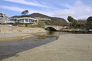
Except for some private development at the mouth of the canyon, the entire Aliso Canyon is mostly undeveloped. This private development consists of a hotel and golf course that also has a stretch of channelized creek. This section of canyon, the steepest and narrowest part, is also vulnerable to flooding during wet years.
Wildlife and plants
The Aliso Canyon has four major vegetation zones; these are riparian, chaparralChaparral
Chaparral is a shrubland or heathland plant community found primarily in the U.S. state of California and in the northern portion of the Baja California peninsula, Mexico...
, coastal sage scrub
Coastal sage scrub
Coastal sage scrub is a low scrubland plant community found in the California chaparral and woodlands ecoregion of coastal California and northern Baja California. It is characterized by low-growing aromatic, and drought-deciduous shrubs adapted to the semi-arid Mediterranean climate of the...
and grassland
Grassland
Grasslands are areas where the vegetation is dominated by grasses and other herbaceous plants . However, sedge and rush families can also be found. Grasslands occur naturally on all continents except Antarctica...
. Historically, there were salt marsh
Salt marsh
A salt marsh is an environment in the upper coastal intertidal zone between land and salt water or brackish water, it is dominated by dense stands of halophytic plants such as herbs, grasses, or low shrubs. These plants are terrestrial in origin and are essential to the stability of the salt marsh...
es at the mouth of Aliso Creek, which sustained a large population of tidewater goby
Tidewater goby
The tidewater goby Eucyclogobius newberryi is a goby native to lagoons of streams along the coast of California.-Taxonomy:The genus name translates as "true cycloid goby", referring to the scales, while the species epithet is in honor of J. S. Newberry. The tidewater goby is the sole member of its...
. These marshes, however, have now been eradicated by the construction of a sewage treatment plant at the mouth. Oak
Oak
An oak is a tree or shrub in the genus Quercus , of which about 600 species exist. "Oak" may also appear in the names of species in related genera, notably Lithocarpus...
and sycamore
Sycamore
Sycamore is a name which is applied at various times and places to three very different types of trees, but with somewhat similar leaf forms....
trees make up the primary large plants along Wood Canyon Creek, and alder
Alder
Alder is the common name of a genus of flowering plants belonging to the birch family . The genus comprises about 30 species of monoecious trees and shrubs, few reaching large size, distributed throughout the North Temperate Zone and in the Americas along the Andes southwards to...
(which gave the canyon its name), live oak
Live oak
Live oak , also known as the southern live oak, is a normally evergreen oak tree native to the southeastern United States...
and other plants line Aliso Creek. Most of the rest of the valley floor, stretching from the edge of the riparian zone to the beginning of the hillside, is grassland. The side canyons and slopes are divided among chaparral and coastal sage scrub. Some non-native plants have begun to establish themselves from the fringes of residential areas on the bordering ridges.
Bobcat
Bobcat
The bobcat is a North American mammal of the cat family Felidae, appearing during the Irvingtonian stage of around 1.8 million years ago . With twelve recognized subspecies, it ranges from southern Canada to northern Mexico, including most of the continental United States...
s, mountain lions, lynx
Lynx
A lynx is any of the four Lynx genus species of medium-sized wildcats. The name "lynx" originated in Middle English via Latin from Greek word "λύγξ", derived from the Indo-European root "*leuk-", meaning "light, brightness", in reference to the luminescence of its reflective eyes...
and coyote
Coyote
The coyote , also known as the American jackal or the prairie wolf, is a species of canine found throughout North and Central America, ranging from Panama in the south, north through Mexico, the United States and Canada...
s are some of the large mammals that inhabit the Aliso Canyon area. There are also more than 100 species of birds, some endangered, including California gnatcatcher
California Gnatcatcher
The California Gnatcatcher, Polioptila californica, is a small 10.8 cm long insectivorous bird which frequents dense coastal sage scrub growth...
, orange-throated whiptail
Orange-throated whiptail
The Orange-throated whiptail is a species of lizard in the family Teiidae. It was previously placed in the genus Cnemidophorus. A. hyperythra has five or six light colored stripes down a black, brown, or grey dorsal side. The middle stripe may be forked at both ends...
, and occasionally, the bald eagle
Bald Eagle
The Bald Eagle is a bird of prey found in North America. It is the national bird and symbol of the United States of America. This sea eagle has two known sub-species and forms a species pair with the White-tailed Eagle...
. Carp
Carp
Carp are various species of oily freshwater fish of the family Cyprinidae, a very large group of fish native to Europe and Asia. The cypriniformes are traditionally grouped with the Characiformes, Siluriformes and Gymnotiformes to create the superorder Ostariophysi, since these groups have certain...
are the only remaining fish that inhabit the lower Aliso Creek. It was once believed that historically steelhead trout spawned in the creek, but it has been found to be a false belief in recent years.
History
Evidence suggests that Aliso Creek was once the boundary of the Acjachemen and Tongva tribes, but Aliso Canyon likely lay completely on Acjachemen land. The mountains to the north and west of the canyon rise more sharply and rise higher than those on the south and east. The northern drainage divide of the gorge marked the boundary in this area, and the Acjachemen settled in small villages all along the valley floor. Fed by springs in the Santa Ana MountainsSanta Ana Mountains
The Santa Ana Mountains are a short peninsular mountain range along the coast of Southern California in the United States. They extend for approximately 36 mi southeast of the Los Angeles Basin largely along the border between Orange and Riverside counties.- Geography :The range starts in the...
and some in the canyon itself, Aliso Creek ran year round through the canyon and supported a lush riparian ecosystem with many tall trees and smaller undergrowth.
Spanish people
The Spanish are citizens of the Kingdom of Spain. Within Spain, there are also a number of vigorous nationalisms and regionalisms, reflecting the country's complex history....
established missions along nearby larger rivers, they forced most of the Native Americans to live at the missions, and Aliso Canyon lay abandoned for many years following the 1770s. The canyon then came under the ownership of Juan Avila in 1842, who operated Rancho Niguel
Rancho Niguel
Rancho Niguel was a Mexican land grant in present day Orange County, California given in 1842 by Governor Juan B. Alvarado to Juan Avila. The rancho was named for a local Indian village called "Niguili." The grant extended along the Pacific coast from Laguna Canyon and Laguna Beach, past Aliso...
that encompassed most of the canyon, an area of about 13500 acres (54.6 km²). The fertile alluvium and extensive grassland
Grassland
Grasslands are areas where the vegetation is dominated by grasses and other herbaceous plants . However, sedge and rush families can also be found. Grasslands occur naturally on all continents except Antarctica...
s of the canyon floor were used primarily for grazing
Grazing
Grazing generally describes a type of feeding, in which a herbivore feeds on plants , and also on other multicellular autotrophs...
cattle. Several corral
Corral
Corral is a town, commune and sea port in Los Ríos Region, Chile. It is located south of Corral Bay. Corral is best known for the forts of Corral Bay, a system of defensive batteries and forts made to protect Valdivia during colonial times. Corral was the headquarters of the system...
s still stand in the Wood Canyon area today. In 1871, pioneer Eugene Salter settled at the canyon mouth, but one year after, sold it to the Thurstons, who cultivated the present-day golf course area as an orchard
Orchard
An orchard is an intentional planting of trees or shrubs that is maintained for food production. Orchards comprise fruit or nut-producing trees which are grown for commercial production. Orchards are also sometimes a feature of large gardens, where they serve an aesthetic as well as a productive...
.
Eventually when the city of Laguna Beach was founded in 1926, the area at the mouth of Aliso Canyon, including Laguna Beach, became a popular camping area. The inn and golf course was begun in the 1960s and grew throughout the remainder of the 20th century. A proposal to extend the golf course into the canyon and expand it to 18 holes was eventually stopped. In the 1960s, Orange County began to fall victim to heavy urbanization, and to protect the canyon from further development, Aliso and Wood Canyons Regional Park was established in 1979 and expanded to its present size by 1990.
A later project to restore a riparian zone in the canyon, the Aliso Creek Wildlife Habitat Enhancement Project (ACWHEP) involved damming the creek and constructing pipelines from the impoundment to irrigate artificial creekside terraces of native plants, as well as prevent further erosion of the canyon floor by urban runoff
Urban runoff
Urban runoff is surface runoff of rainwater created by urbanization. This runoff is a major source of water pollution in many parts of the United States and other urban communities worldwide.-Overview:...
. Due to a flaw in the design, the dam actually caused further erosion, and the irrigation pipes are now broken and the terraces lie fallow.
Marine fossils
The Pecten Reef in the northeast section of the canyon area is an above-ground exposure of the Monterey FormationMonterey Formation
The Monterey Formation is an extensive Miocene oil-rich geological sedimentary formation in California, with massive outcroppings of the formation in areas of the California Coast Ranges, Peninsular Ranges, and on some of California's off-shore islands...
, which dates back to the Miocene
Miocene
The Miocene is a geological epoch of the Neogene Period and extends from about . The Miocene was named by Sir Charles Lyell. Its name comes from the Greek words and and means "less recent" because it has 18% fewer modern sea invertebrates than the Pliocene. The Miocene follows the Oligocene...
period. Thousands of fossils and specimens of marine mammals, fish, reptiles and coastal birds have been discovered at the site, implying that the site was once underwater. Preserved invertebrate
Invertebrate
An invertebrate is an animal without a backbone. The group includes 97% of all animal species – all animals except those in the chordate subphylum Vertebrata .Invertebrates form a paraphyletic group...
s, plankton
Plankton
Plankton are any drifting organisms that inhabit the pelagic zone of oceans, seas, or bodies of fresh water. That is, plankton are defined by their ecological niche rather than phylogenetic or taxonomic classification...
, bryozoa
Bryozoa
The Bryozoa, also known as Ectoprocta or commonly as moss animals, are a phylum of aquatic invertebrate animals. Typically about long, they are filter feeders that sieve food particles out of the water using a retractable lophophore, a "crown" of tentacles lined with cilia...
, and rare red, blue and brown algae
Algae
Algae are a large and diverse group of simple, typically autotrophic organisms, ranging from unicellular to multicellular forms, such as the giant kelps that grow to 65 meters in length. They are photosynthetic like plants, and "simple" because their tissues are not organized into the many...
have also been found there. Much of the scientific understanding for evolution, paleoenvironments and paleoclimates during the Miocene period in Orange County is based on the specimens collected from the Pecten Reef.