

Alderton, Northamptonshire
Encyclopedia
Alderton is an English village and civil parish
about 9 miles (14.5 km) south of Northampton
, and 10 miles (16.1 km) north of Milton Keynes
, along a road between the A5
and A508 main roads in the southwest and northeast respectively. The nearest large town is Towcester
, about 3 miles (4.8 km) north. The village is famous for the remains of an English Heritage
Scheduled Ancient Monument
, a Norman Castle
, known locally as "The Mount", which was the subject of an investigation by the Channel 4
programme Time Team
.
data is grouped with the nearby village of Grafton Regis and showed there were 248 people living in both villages, 134 male, 114 female, in 94 dwellings. The majority of these being in Grafton Regis. In 2009 the estimated population of Alderton itself was 109.
in 1935. An independent Parish Council for the village was re-established on 1 April 2004.
The local district council is South Northamptonshire
and Alderton is in the area of Northamptonshire County Council.
which flows east between the village and Stoke Bruerne
to the north. Stoke Bruerne church and Stoke Park Pavilions
are clearly visible in the distance.
. Later the Romans
built major roads including Watling Street
, the A5, only 0.5 mile (0.80467 km) southwest of the village. Domestic Roman artefacts have been found and large villas and farming communities were established nearby. The nearest known Roman villa was the Piddington Roman Villa
at the village of Piddington
, about 6 miles (9.7 km) away. Iron Age, Roman and Saxon artefacts have been found on The Mount.
Alderton became a larger Saxon settlement and a Saxon burh
is thought to have stood on the high ground and would have included the Mount site. The village lies on what was the frontier between the Saxon kingdoms of the south and the Danelaw
in the north.
The 1066 Norman conquest saw the development of the ringwork castle in the form visible today. This was one of the strongholds owned by Robert, Count of Mortain the half brother of William the Conqueror. It was an imposing earthwork hastily constructed to form part of the defence William's new kingdom. Twenty years later, the Domesday Book
entry for Alderton shows the name as "Aldrintone" and the Earl of Ferrers as the local lord and lists land for 8 ploughs.
Recent archaeological research points to the castle being abandoned in the latter half of the 14th century. This was at the time of the Black Death when there appears to have been a sharp reduction in the local population as elsewhere in Britain. Alderton came under the control of the Manor of Stoke Bruerne.
Alderton was a very small community throughout the 14th and 15th centuries. By 1541 King Henry VIII
had included the village within the Honour of Grafton
. The village population grew in the latter half of the 16th century with the arrival of William Gorges, a nobleman from a distinguished aristocratic line. Gorges built a very large mansion house with landscaped gardens. Through the marriage of Gorges' daughter Frances to Thomas Hesilrige
, the Manor House passed to the Heselrige
family. In 1605, Queen Anne of Denmark stayed at Alderton Manor and in 1608 King James I
visited and knighted Thomas Hesilrige who later became a baronet. Hesilrige's son Sir Arthur Hesilrige, 2nd Baronet, a close ally of John Pym
and Oliver Cromwell
and one of the Five Members, was Lord of the Manor in 1655.
By the early 18th century the village was a thriving agricultural community. The Manor House was demolished and its site was occupied by a substantial farm, known as Manor Farm. The village population remained small and largely involved in agriculture. Recently, it has changed character and is now a dormitory settlement for professional people; it is also a conservation area.
 The castle and Manor of Alderton were sold by Thomas le Sauvage to Pagan de Chaworth during the reign of Edward I. During the first English Civil War there were a number of engagements in the vicinity, most notably the siege and eventual destruction of Grafton Manor House in 1644. Parliamentarian forces involved in this action passed through Alderton. There is little evidence of any significant use of the castle at this time, however. Some civil war musket balls have been discovered but may be associated with musket practice. Certainly it is documented that during the 18th century the site was used as a gentlemen's rifling range.
During the Victorian era the castle appears to have been a popular picnic spot, judging by the recent porcelain and glass finds. This use as a village amenity has continued to the present day. In 1998 Derek Batten, a resident of the neighbouring village of Paulerspury
and former County Councillor, purchased the castle site.
Arthur Hesilrige, of Alderton, was one of the five MP
s impeached by King Charles I
in 1642.
Civil parish
In England, a civil parish is a territorial designation and, where they are found, the lowest tier of local government below districts and counties...
about 9 miles (14.5 km) south of Northampton
Northampton
Northampton is a large market town and local government district in the East Midlands region of England. Situated about north-west of London and around south-east of Birmingham, Northampton lies on the River Nene and is the county town of Northamptonshire. The demonym of Northampton is...
, and 10 miles (16.1 km) north of Milton Keynes
Milton Keynes
Milton Keynes , sometimes abbreviated MK, is a large town in Buckinghamshire, in the south east of England, about north-west of London. It is the administrative centre of the Borough of Milton Keynes...
, along a road between the A5
A5 road
The A5 is a major road in England and Wales. It is also the first Roman built road in England hence the name Roman Road. It runs for about from London, England to Holyhead, Wales, following in part a section of the Roman Iter II route which later took the Anglo-Saxon name Watling...
and A508 main roads in the southwest and northeast respectively. The nearest large town is Towcester
Towcester
Towcester , the Roman town of Lactodorum, is a small town in south Northamptonshire, England.-Etymology:Towcester comes from the Old English Tófe-ceaster. Tófe refers to the River Tove; Bosworth and Toller compare it to the "Scandinavian proper names" Tófi and Tófa...
, about 3 miles (4.8 km) north. The village is famous for the remains of an English Heritage
English Heritage
English Heritage . is an executive non-departmental public body of the British Government sponsored by the Department for Culture, Media and Sport...
Scheduled Ancient Monument
Scheduled Ancient Monument
In the United Kingdom, a scheduled monument is a 'nationally important' archaeological site or historic building, given protection against unauthorized change. The various pieces of legislation used for legally protecting heritage assets from damage and destruction are grouped under the term...
, a Norman Castle
Castle
A castle is a type of fortified structure built in Europe and the Middle East during the Middle Ages by European nobility. Scholars debate the scope of the word castle, but usually consider it to be the private fortified residence of a lord or noble...
, known locally as "The Mount", which was the subject of an investigation by the Channel 4
Channel 4
Channel 4 is a British public-service television broadcaster which began working on 2 November 1982. Although largely commercially self-funded, it is ultimately publicly owned; originally a subsidiary of the Independent Broadcasting Authority , the station is now owned and operated by the Channel...
programme Time Team
Time Team
Time Team is a British television series which has been aired on Channel 4 since 1994. Created by television producer Tim Taylor and presented by actor Tony Robinson, each episode features a team of specialists carrying out an archaeological dig over a period of three days, with Robinson explaining...
.
Demographics
The 2001 censusCensus
A census is the procedure of systematically acquiring and recording information about the members of a given population. It is a regularly occurring and official count of a particular population. The term is used mostly in connection with national population and housing censuses; other common...
data is grouped with the nearby village of Grafton Regis and showed there were 248 people living in both villages, 134 male, 114 female, in 94 dwellings. The majority of these being in Grafton Regis. In 2009 the estimated population of Alderton itself was 109.
Governance
The parish was merged with Grafton RegisGrafton Regis
Grafton Regis is a village and civil parish in the south of the English county of Northamptonshire. The village is east of the A508 road, on which it has a short frontage and two bus stops. It is ca. south of Northampton and north of Milton Keynes....
in 1935. An independent Parish Council for the village was re-established on 1 April 2004.
The local district council is South Northamptonshire
South Northamptonshire
South Northamptonshire is a local government district in Northamptonshire, England. Its council is based in Towcester.The district is rural and sparsely populated with just over 79,293 people in 2000 and 91,000 in 2008, a 14.8% increase. The largest town in the district is Brackley, which has a...
and Alderton is in the area of Northamptonshire County Council.
Geography
Alderton is on the southern ridge of the valley of the River ToveRiver Tove
The River Tove is a river in England, a tributary of the River Great Ouse. Rising in Northamptonshire, it flows for around 15 miles past the town of Towcester before meeting the Ouse near Milton Keynes. Its final 5 miles form part of the border between Northamptonshire and Buckinghamshire, running...
which flows east between the village and Stoke Bruerne
Stoke Bruerne
Stoke Bruerne is a small village and civil parish in South Northamptonshire, England about north of Milton Keynes and south of Northampton.-History:...
to the north. Stoke Bruerne church and Stoke Park Pavilions
Stoke Park Pavilions
Stoke Park Pavilions are all that remain of the stately house and grounds of Stoke Park near the village of Stoke Bruerne, Northamptonshire, England, approximately south of Northampton and north of Milton Keynes.- Stoke Park :...
are clearly visible in the distance.
History
There is evidence of settlement at Alderton in the Iron AgeIron Age
The Iron Age is the archaeological period generally occurring after the Bronze Age, marked by the prevalent use of iron. The early period of the age is characterized by the widespread use of iron or steel. The adoption of such material coincided with other changes in society, including differing...
. Later the Romans
Roman Empire
The Roman Empire was the post-Republican period of the ancient Roman civilization, characterised by an autocratic form of government and large territorial holdings in Europe and around the Mediterranean....
built major roads including Watling Street
Watling Street
Watling Street is the name given to an ancient trackway in England and Wales that was first used by the Britons mainly between the modern cities of Canterbury and St Albans. The Romans later paved the route, part of which is identified on the Antonine Itinerary as Iter III: "Item a Londinio ad...
, the A5, only 0.5 mile (0.80467 km) southwest of the village. Domestic Roman artefacts have been found and large villas and farming communities were established nearby. The nearest known Roman villa was the Piddington Roman Villa
Piddington Roman Villa
Piddington Roman Villa is the remains of a large Roman villa at Piddington, Northamptonshire, about south-east of Northampton.-Location and Directions:The villa is on the site of an earlier late Iron Age settlement...
at the village of Piddington
Piddington, Northamptonshire
Piddington is a village in the south of the English shire county of Northamptonshire. known as Northants in the district of South Northamptonshire, just north of Buckinghamshire. It is south of Northampton town centre, in a cul-de-sac off the main road, at the War Memorial in the village of...
, about 6 miles (9.7 km) away. Iron Age, Roman and Saxon artefacts have been found on The Mount.
Alderton became a larger Saxon settlement and a Saxon burh
Burh
A Burh is an Old English name for a fortified town or other defended site, sometimes centred upon a hill fort though always intended as a place of permanent settlement, its origin was in military defence; "it represented only a stage, though a vitally important one, in the evolution of the...
is thought to have stood on the high ground and would have included the Mount site. The village lies on what was the frontier between the Saxon kingdoms of the south and the Danelaw
Danelaw
The Danelaw, as recorded in the Anglo-Saxon Chronicle , is a historical name given to the part of England in which the laws of the "Danes" held sway and dominated those of the Anglo-Saxons. It is contrasted with "West Saxon law" and "Mercian law". The term has been extended by modern historians to...
in the north.
The 1066 Norman conquest saw the development of the ringwork castle in the form visible today. This was one of the strongholds owned by Robert, Count of Mortain the half brother of William the Conqueror. It was an imposing earthwork hastily constructed to form part of the defence William's new kingdom. Twenty years later, the Domesday Book
Domesday Book
Domesday Book , now held at The National Archives, Kew, Richmond upon Thames in South West London, is the record of the great survey of much of England and parts of Wales completed in 1086...
entry for Alderton shows the name as "Aldrintone" and the Earl of Ferrers as the local lord and lists land for 8 ploughs.
Recent archaeological research points to the castle being abandoned in the latter half of the 14th century. This was at the time of the Black Death when there appears to have been a sharp reduction in the local population as elsewhere in Britain. Alderton came under the control of the Manor of Stoke Bruerne.
Alderton was a very small community throughout the 14th and 15th centuries. By 1541 King Henry VIII
Henry VIII of England
Henry VIII was King of England from 21 April 1509 until his death. He was Lord, and later King, of Ireland, as well as continuing the nominal claim by the English monarchs to the Kingdom of France...
had included the village within the Honour of Grafton
Honour of Grafton
The Honour of Grafton is a collection of manors in the south east of Northamptonshire, England. The Honour is historic, dating back at least as far as 1542 when a bill for its management was before parliament....
. The village population grew in the latter half of the 16th century with the arrival of William Gorges, a nobleman from a distinguished aristocratic line. Gorges built a very large mansion house with landscaped gardens. Through the marriage of Gorges' daughter Frances to Thomas Hesilrige
Sir Thomas Hesilrige, 1st Baronet
Sir Thomas Hesilrige, 1st Baronet was an English politician who sat in the House of Commons in 1614 and 1624.Hesilrige was the son of Thomas Hesilrige of Noseley Hall, Noseley, Leicestershire and his wife Ursula Andrews daughter of Sir Thomas Andrews of Charwelton, Northamptonshire and his wife...
, the Manor House passed to the Heselrige
Baron Hazlerigg
Baron Hazlerigg, of Noseley in the County of Leicester, is a title in the Peerage of the United Kingdom. It was created in 1945 for Sir Arthur Hazlerigg, 13th Baronet. He had previously served as Lord Lieutenant of Leicestershire...
family. In 1605, Queen Anne of Denmark stayed at Alderton Manor and in 1608 King James I
James I of England
James VI and I was King of Scots as James VI from 24 July 1567 and King of England and Ireland as James I from the union of the English and Scottish crowns on 24 March 1603...
visited and knighted Thomas Hesilrige who later became a baronet. Hesilrige's son Sir Arthur Hesilrige, 2nd Baronet, a close ally of John Pym
John Pym
John Pym was an English parliamentarian, leader of the Long Parliament and a prominent critic of James I and then Charles I.- Early life and education :...
and Oliver Cromwell
Oliver Cromwell
Oliver Cromwell was an English military and political leader who overthrew the English monarchy and temporarily turned England into a republican Commonwealth, and served as Lord Protector of England, Scotland, and Ireland....
and one of the Five Members, was Lord of the Manor in 1655.
By the early 18th century the village was a thriving agricultural community. The Manor House was demolished and its site was occupied by a substantial farm, known as Manor Farm. The village population remained small and largely involved in agriculture. Recently, it has changed character and is now a dormitory settlement for professional people; it is also a conservation area.
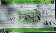
The Mount
This is the remains of a ringwork castle which is now overgrown with trees. The earthworks are still in a good state of preservation and comprise an area of about 2 acres (8,093.7 m²). The ditch is 5 metres deep in parts and still fully accessible. The internal area of the castle has some slightly raised areas interpreted as building platforms.During the Victorian era the castle appears to have been a popular picnic spot, judging by the recent porcelain and glass finds. This use as a village amenity has continued to the present day. In 1998 Derek Batten, a resident of the neighbouring village of Paulerspury
Paulerspury
Paulerspury is a civil parish and small village in South Northamptonshire, England. It is approximately south of Towcester and north of Milton Keynes along the A5 road...
and former County Councillor, purchased the castle site.
Time Team visit
As The Mount is a scheduled ancient monument, ordinarily Channel 4's Time Team would not be given permission to excavate the site. Because so little is known about it, however – and about this type of castle in general – English Heritage did on this occasion grant permission for the Team to dig in three specific areas. One of these was in the ditch surrounding the castle; one on the ramparts; and one inside the castle. The aim, according to Glyn Coppack, the English Heritage inspector with responsibility for the excavation, was to obtain 'the maximum amount of information for the minimum disturbance of the site'. The program was broadcast on 14 January 2001 and is summarised on the Time Team website.Medieval Castle
In August 2009, archaeologists uncovered what they believed were remains of the only medieval stone castle in South Northamptonshire, after they picked up where Time Team's archaeologists left off eight years before.Church of St Margaret
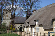
The building dates from 1522–1528 and later 1848. There is a monument to Sir William de Combermartin (d.ca.1318)Notable residents
SirSir
Sir is an honorific used as a title , or as a courtesy title to address a man without using his given or family name in many English speaking cultures...
Arthur Hesilrige, of Alderton, was one of the five MP
Member of Parliament
A Member of Parliament is a representative of the voters to a :parliament. In many countries with bicameral parliaments, the term applies specifically to members of the lower house, as upper houses often have a different title, such as senate, and thus also have different titles for its members,...
s impeached by King Charles I
Charles I of England
Charles I was King of England, King of Scotland, and King of Ireland from 27 March 1625 until his execution in 1649. Charles engaged in a struggle for power with the Parliament of England, attempting to obtain royal revenue whilst Parliament sought to curb his Royal prerogative which Charles...
in 1642.