
Piddington, Northamptonshire
Encyclopedia
Piddington is a village in the south of the English shire
county
of Northamptonshire
. known as Northants in the district of South Northamptonshire
, just north of Buckinghamshire
. It is 6 miles (10 km) south of Northampton
town centre, in a cul-de-sac
off the main road, at the War Memorial in the village of Hackleton
and about 1 miles (2 km) south-west of there. It has a geographic size of 1693 acres (6.9 km²) and an average height of 300 ft (91.4 m), rising steadily to 400 ft (121.9 m) in Salcey Forest
.
parish which in total has a population of 1,568 according to the 2001 census
and contains 606 dwellings. Piddington itself is estimated to have a population of 652 in 2010.
and Horton
as well.
.
Piddington was once very important. In Roman times, one of the most important roads in the country, used to transport troops, ran through the village.
By the time of the domesday book in 1086, the land around Piddington was owned by William the Conqueror's niece; Louise.
By the 1870s, Piddington was linked to the national rail network by the Bedford to Northampton Line
which provided a station to serve the village
. The Stratford and Midland Junction Railway, known as the "SMJ", also opened a station at to the south of Horton
village. This part of the line ran from Towcester
to Blisworth
and Stoke Bruerne
with a connection to Northampton and the West Coast Main Line
. It closed to passengers in 1951, and was later shut completely as part of the 1960s Beeching
cuts. The route of the line is just to the southeast of the village and is clearly visible, with a railway bridge marked with a weight restriction, at the side of the chicken farm. The track bed is intact but the railway bridge is cracked, possibly caused by a vehicle collision (see picture in gallery).
To the west of the village, there is a disused quarry marked on Ordnance Survey
maps but barely visible due to a copse of trees. This was used for lime burning up until 1924/25. The stream running from Horton to Preston Deanery very close to the village on the north side was once the divide between the Hamlet of Hackleton and Piddington but in 1935 the amalgamation of the parishes created the civil parish of Hackleton.
A village shop on Forest Road, the main road in the village, closed in the 1980s. The village is now served by the village shop and Post Office in nearby Hackleton. A petrol station and garage at 23 Forest Road have also long since gone.
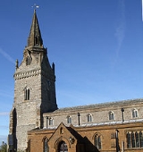
The village church, St. John the Baptist, was built in the 13th century, although the majority of it has been added on since. It is also believed there was a place of worship situated on the site before the erection of the church in 1290.
The "pocket park" was previously a private field for livestock, left by the owner to the village in his will.
Shire
A shire is a traditional term for a division of land, found in the United Kingdom and in Australia. In parts of Australia, a shire is an administrative unit, but it is not synonymous with "county" there, which is a land registration unit. Individually, or as a suffix in Scotland and in the far...
county
County
A county is a jurisdiction of local government in certain modern nations. Historically in mainland Europe, the original French term, comté, and its equivalents in other languages denoted a jurisdiction under the sovereignty of a count A county is a jurisdiction of local government in certain...
of Northamptonshire
Northamptonshire
Northamptonshire is a landlocked county in the English East Midlands, with a population of 629,676 as at the 2001 census. It has boundaries with the ceremonial counties of Warwickshire to the west, Leicestershire and Rutland to the north, Cambridgeshire to the east, Bedfordshire to the south-east,...
. known as Northants in the district of South Northamptonshire
South Northamptonshire
South Northamptonshire is a local government district in Northamptonshire, England. Its council is based in Towcester.The district is rural and sparsely populated with just over 79,293 people in 2000 and 91,000 in 2008, a 14.8% increase. The largest town in the district is Brackley, which has a...
, just north of Buckinghamshire
Buckinghamshire
Buckinghamshire is a ceremonial and non-metropolitan home county in South East England. The county town is Aylesbury, the largest town in the ceremonial county is Milton Keynes and largest town in the non-metropolitan county is High Wycombe....
. It is 6 miles (10 km) south of Northampton
Northampton
Northampton is a large market town and local government district in the East Midlands region of England. Situated about north-west of London and around south-east of Birmingham, Northampton lies on the River Nene and is the county town of Northamptonshire. The demonym of Northampton is...
town centre, in a cul-de-sac
Cul-de-sac
A cul-de-sac is a word of French origin referring to a dead end, close, no through road or court meaning dead-end street with only one inlet/outlet...
off the main road, at the War Memorial in the village of Hackleton
Hackleton
Hackleton is a village located in the south of the English shire county of Northamptonshire in the district of South Northamptonshire, just north of Buckinghamshire. It is south of Northampton town centre, and by road to the M1 London to Yorkshire motorway junction 15 and north of junction 14....
and about 1 miles (2 km) south-west of there. It has a geographic size of 1693 acres (6.9 km²) and an average height of 300 ft (91.4 m), rising steadily to 400 ft (121.9 m) in Salcey Forest
Salcey Forest
Salcey Forest is a former medieval hunting forest in the south of the county of Northamptonshire in England.It lies to the east of the village of Hartwell, between Northampton and Newport Pagnell...
.
Demographics
It is part of HackletonHackleton
Hackleton is a village located in the south of the English shire county of Northamptonshire in the district of South Northamptonshire, just north of Buckinghamshire. It is south of Northampton town centre, and by road to the M1 London to Yorkshire motorway junction 15 and north of junction 14....
parish which in total has a population of 1,568 according to the 2001 census
United Kingdom Census 2001
A nationwide census, known as Census 2001, was conducted in the United Kingdom on Sunday, 29 April 2001. This was the 20th UK Census and recorded a resident population of 58,789,194....
and contains 606 dwellings. Piddington itself is estimated to have a population of 652 in 2010.
Governance
The village is part of Hackleton parish council which also covers the nearby villages of Preston DeaneryPreston Deanery
Preston Deanery is a hamlet in the civil parish of Hackleton in South Northamptonshire, England. It is south of Northampton town centre and by road to the M1 London to Yorkshire motorway junction 15...
and Horton
Horton, Northamptonshire
Horton is named from the Old English meaning "muddy farmstead" and lies in the English county of Northamptonshire. It was originally an estate village, serving the now demolished Horton House and it is close to its neighbouring village Hackleton...
as well.
History
It is the site of the Piddington Roman VillaPiddington Roman Villa
Piddington Roman Villa is the remains of a large Roman villa at Piddington, Northamptonshire, about south-east of Northampton.-Location and Directions:The villa is on the site of an earlier late Iron Age settlement...
.
Piddington was once very important. In Roman times, one of the most important roads in the country, used to transport troops, ran through the village.
By the time of the domesday book in 1086, the land around Piddington was owned by William the Conqueror's niece; Louise.
By the 1870s, Piddington was linked to the national rail network by the Bedford to Northampton Line
Bedford to Northampton Line
The Bedford to Northampton Line was a branch of the Midland Railway which served stations in three counties: Northampton and Horton in Northamptonshire, Olney in Buckinghamshire and Turvey and Bedford in Bedfordshire, England...
which provided a station to serve the village
Piddington railway station
Piddington was a railway station on the former Bedford to Northampton Line. Despite its name, the station was located close to the village of Horton in Northamptonshire, approximately from the village of Piddington.- History :...
. The Stratford and Midland Junction Railway, known as the "SMJ", also opened a station at to the south of Horton
Horton, Northamptonshire
Horton is named from the Old English meaning "muddy farmstead" and lies in the English county of Northamptonshire. It was originally an estate village, serving the now demolished Horton House and it is close to its neighbouring village Hackleton...
village. This part of the line ran from Towcester
Towcester
Towcester , the Roman town of Lactodorum, is a small town in south Northamptonshire, England.-Etymology:Towcester comes from the Old English Tófe-ceaster. Tófe refers to the River Tove; Bosworth and Toller compare it to the "Scandinavian proper names" Tófi and Tófa...
to Blisworth
Blisworth
Blisworth is a village and civil parish in the South Northamptonshire district of Northamptonshire, England. The West Coast Main Line, from London Euston to Manchester and Scotland, runs alongside the village partly hidden and partly on an embankment...
and Stoke Bruerne
Stoke Bruerne
Stoke Bruerne is a small village and civil parish in South Northamptonshire, England about north of Milton Keynes and south of Northampton.-History:...
with a connection to Northampton and the West Coast Main Line
West Coast Main Line
The West Coast Main Line is the busiest mixed-traffic railway route in Britain, being the country's most important rail backbone in terms of population served. Fast, long-distance inter-city passenger services are provided between London, the West Midlands, the North West, North Wales and the...
. It closed to passengers in 1951, and was later shut completely as part of the 1960s Beeching
Beeching Axe
The Beeching Axe or the Beeching Cuts are informal names for the British Government's attempt in the 1960s to reduce the cost of running British Railways, the nationalised railway system in the United Kingdom. The name is that of the main author of The Reshaping of British Railways, Dr Richard...
cuts. The route of the line is just to the southeast of the village and is clearly visible, with a railway bridge marked with a weight restriction, at the side of the chicken farm. The track bed is intact but the railway bridge is cracked, possibly caused by a vehicle collision (see picture in gallery).
To the west of the village, there is a disused quarry marked on Ordnance Survey
Ordnance Survey
Ordnance Survey , an executive agency and non-ministerial government department of the Government of the United Kingdom, is the national mapping agency for Great Britain, producing maps of Great Britain , and one of the world's largest producers of maps.The name reflects its creation together with...
maps but barely visible due to a copse of trees. This was used for lime burning up until 1924/25. The stream running from Horton to Preston Deanery very close to the village on the north side was once the divide between the Hamlet of Hackleton and Piddington but in 1935 the amalgamation of the parishes created the civil parish of Hackleton.
Facilities
It consists of approximately 300 houses, a church, a "pocket park",an egg farm and pub "The Spread Eagle". A second pub, "The White Hart", is on the main road in Hackleton. Both are popular with "locals" as well as "out of towners".A village shop on Forest Road, the main road in the village, closed in the 1980s. The village is now served by the village shop and Post Office in nearby Hackleton. A petrol station and garage at 23 Forest Road have also long since gone.
The village church, St. John the Baptist, was built in the 13th century, although the majority of it has been added on since. It is also believed there was a place of worship situated on the site before the erection of the church in 1290.
The "pocket park" was previously a private field for livestock, left by the owner to the village in his will.