
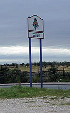
Abram, Greater Manchester
Encyclopedia
Abram is a village and electoral ward
within the Metropolitan Borough of Wigan
, in Greater Manchester
, England. It lies on flat land on the northeast bank of the Leeds and Liverpool Canal
, 2 miles (3.2 km) west of Leigh
, 3 miles (4.8 km) southeast of Wigan
, and 14.5 miles (23 km) west of Manchester
. Abram is a dormitory village, effectively a suburb
, comprising a resident population of 9,855 people.
Historically
a part of Lancashire
, Abram anciently formed a township
and chapelry
in the parish of Wigan and hundred of West Derby
. Abram appears in an entry of an ancient survey of Lancashire in 1212 under the name "Edburgham", and throughout the Middle Ages
was governed by ruling families
.
The urbanisation and development of Abram largely coincided with the Industrial Revolution
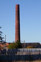
. Abram is situated in the centre of a coal district, and industrial scale coal mining
was introduced to Abram around the middle of the 19th century with the opening of several collieries. In 1911, Abram was described as "distinctly unpicturesque ... trees are in the minority, and stunted and blackened with smoke", with "collieries, pit-banks, and railway lines" as well as "much pasture land". The Maypole Colliery Disaster in 1908 resulted in 75 deaths and profoundly changed the character of the village.
Abram's coal mining industry demised during the mid-20th century, however the village has continued to grow, supported by its position between Leigh, Manchester, Warrington
and Wigan. To the south of the village lies Abram Flashes, a 39.6 hectares (97.9 acre) area of shallow wetlands and a Site of Special Scientific Interest. Abram has historic associations with traditional morris dancing
and is home to the Abram Morris Dancers.
 The village name has been variously recorded as Edburgham in 1212 and Adburgham in 1246. In the 16th century it had evolved into Abraham, and by the 17th century the current name of Abram had become prevalent. It is suggested that Abram derives from Abraham
, the surname of the medieval Lords of the Manor
.
The manor
was probably part of the larger manor of Newton until it was granted to "Warine son of Godfrey" by Henry II
who reigned 1154–1189. The family adopted the name of the settlement, and remained Lords of the Manor until the 17th century. The family was ruined by the English Civil War
, in which they supported the Royalists. When the last in male line of the Abraham family died in the 17th century, possession of the manor passed through many hands, and the title of Lord of the Manor was still around at the start of the 20th century although held no manorial rights.
Just after 17:00 on the 18 August 1908 there was an explosion
at the No 1, Cannell Mine of the Maypole Coal Pit. A total of 75 men and boys died in this mining accident
. Because the explosion occurred deep underground, it was not until November 1909 that all the bodies were recovered. The inquest ruled that the explosion was caused by a combination of a build up of coal dust
and gas
, and the use of explosives to bring down coal from the ceiling. The physical effects of the disaster on Abram are described as "profound"; the explosion made 44 women widows and killed the fathers of more than 120 children. At the time, Irish people
were a large ethnic minority in Lancashire, making up between a quarter and a third of the populations of Leigh
, St Helens
, and Wigan
. The Irish Catholic immigrants were seeking works in the Lancashire coal fields, as demonstrated by the fact that 13 of the dead were Catholic migrants from Ireland. Many of the families affected by the disaster returned to Ireland shortly afterwards.
 Lying within the historic county boundaries
of Lancashire
since the early 12th century, Abram anciently constituted a manor
, held by ruling families
who paid tax to the King. Abram during the Middle Ages
formed a township
in the ecclesiastical parish of Wigan, and hundred of West Derby
.
Following the Poor Law Amendment Act 1834
, Abram formed part of the Wigan Poor Law Union
, an inter-parish unit established to provide social security
. Abram's first local authority was a Local board of health
established in 1880; Abram Local Board of Health was a regulatory body responsible for standards of hygiene and sanitation in the township. Following the Local Government Act 1894
, the area of the Local Board became the Abram Urban District, a local government district within the administrative county
of Lancashire. The urban district council had 12 members and was based out of Abram Urban District Council Offices. In 1957 there were exchanges of very small areas with Ashton in Makerfield and Golborne Urban Districts. Under the Local Government Act 1972
, the Abram Urban District was abolished, and Abram has, since 1 April 1974, formed an unparished area
of the Metropolitan Borough of Wigan
, a local government district of the metropolitan county
of Greater Manchester
. Wigan Metropolitan Borough Council provides the local services.
In terms of parliamentary representation, Abram is part of the Makerfield constituency
; the Member of Parliament
is Yvonne Fovargue
, a Labour
politician.
, Abram lies on mostly flat ground, with slightly undulating land at its southern end. The larger towns of Wigan
and Leigh
lie to the northwest and east respectively. For purposes of the Office for National Statistics
, Abram forms part of the Wigan Urban Area
. Suburban localities in and around Abram include Bamfurlong
, Bickershaw
, Bryn Gates and Platt Bridge
.
The land around Abram is generally flat and used for coal mining as well as arable farming
. As a result, collieries were scattered across the landscape. The local geology consists of coal measures in the north and sandstone in the south; the soil is clayey and as a result, the area is susceptible to flooding.
To the south of the village lies Abram Flashes a 39.6 hectares (97.9 acre) Site of Special Scientific Interest (SSSI). The site lies adjacent to the Leigh
Branch Canal
and is part of Wigan Flashes an area of wetland stretching for 10 kilometres (6.2 mi) between Wigan and Leigh. The flashes are shallow bodies of water which originate from flooding due to subsidence caused by shallow-mining. Abram flashes was designated an SSSI in 1990 due to its biological interest which includes various habitats such as open water, swamp
, tall herb fen
and wet marshy grassland
.
According to the Office for National Statistics
, at the time of the United Kingdom Census 2001
, Abram had a population of 9,855. The 2001 population density was 14258 PD/sqmi, with a 100 to 99.7 female-to-male ratio. Of those over 16 years old, 30.3% were single (never married) and 43.2% married. Abram's 4,037 households included 27.2% one-person, 40.0% married couples living together, 9.5% were co-habiting
couples, and 12.5% single parents with their children. Of those aged 16–74, 42.2% had no academic qualifications
.
As of the 2001 UK census, 84.7% of Abram's residents reported themselves as being Christian, 0.9% Muslim, 0.2% Buddhist and 0.1% Sikh. The census recorded 6.5% as having no religion, 0.1% had an alternative religion and 7.5% did not state their religion.
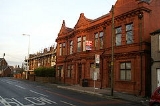
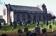 The parish church of St John in Abram was constructed in 1935–1937, and is one of the works by Austin and Paley. There are two listed buildings in the village, both of which are Grade II; they are Brookside farmhouse, dating from the early-18th century, and a mid-18th century detached house on Warrington Road.
in Abram is co-ordinated by the Greater Manchester Passenger Transport Executive
. A roads link Abram with other settlements, including the A573 road which bisects the town from north to south, and connects it to Wigan and Golborne
. The M6 motorway
runs to the southwest of the area, near Ashton in Makerfield, and is accessed via the A58
at junction 24 of the M6.
Bickershaw and Abram railway station was a station on the now closed Wigan Central to Glazebrook line. It opened along with six other stations on 1 April 1884. It closed on 2 November 1964.
There are frequent buses running through Abram with services to a variety of destinations in Greater Manchester, including services to Wigan, Leigh and Manchester.
The Leeds and Liverpool Canal
passes Abram to the southwest.
 The village has historic associations with traditional morris dancing
and is home to Abram Morris Dancers. A plot of land by Park Lane in the southwest of Abram is known as the Morris Dancers' ground, and is popularly supposed to be held by the Abram Morris Dancers on condition that a morris dance be celebrated there once every 20 years. The Abram Circle is a dance native to Abram and is "renowned to morris dancers". The Abram Morris Dancers' logo appears on the boundary signs for the village.
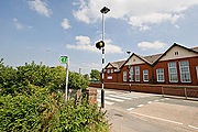
Abram has two primary schools: Abram Bryn Gates Primary School, and Abram Church of England Primary School.
was an Abram-born recipient of the Victoria Cross
, the highest military decoration awarded for valour "in the face of the enemy" to members of the British and Commonwealth forces.
Wards of the United Kingdom
A ward in the United Kingdom is an electoral district at sub-national level represented by one or more councillors. It is the primary unit of British administrative and electoral geography .-England:...
within the Metropolitan Borough of Wigan
Metropolitan Borough of Wigan
The Metropolitan Borough of Wigan is a metropolitan borough of Greater Manchester, in North West England. It is named after its largest component town, Wigan and also includes the towns of Leigh, Ashton-in-Makerfield, Ince-in-Makerfield, and Hindley. The borough was formed in 1974 and is an...
, in Greater Manchester
Greater Manchester
Greater Manchester is a metropolitan county in North West England, with a population of 2.6 million. It encompasses one of the largest metropolitan areas in the United Kingdom and comprises ten metropolitan boroughs: Bolton, Bury, Oldham, Rochdale, Stockport, Tameside, Trafford, Wigan, and the...
, England. It lies on flat land on the northeast bank of the Leeds and Liverpool Canal
Leeds and Liverpool Canal
The Leeds and Liverpool Canal is a canal in Northern England, linking the cities of Leeds and Liverpool. Over a distance of , it crosses the Pennines, and includes 91 locks on the main line...
, 2 miles (3.2 km) west of Leigh
Leigh, Greater Manchester
Leigh is a town within the Metropolitan Borough of Wigan, in Greater Manchester, England. It is southeast of Wigan, and west of Manchester. Leigh is situated on low lying land to the north west of Chat Moss....
, 3 miles (4.8 km) southeast of Wigan
Wigan
Wigan is a town in Greater Manchester, England. It stands on the River Douglas, south-west of Bolton, north of Warrington and west-northwest of Manchester. Wigan is the largest settlement in the Metropolitan Borough of Wigan and is its administrative centre. The town of Wigan had a total...
, and 14.5 miles (23 km) west of Manchester
Manchester
Manchester is a city and metropolitan borough in Greater Manchester, England. According to the Office for National Statistics, the 2010 mid-year population estimate for Manchester was 498,800. Manchester lies within one of the UK's largest metropolitan areas, the metropolitan county of Greater...
. Abram is a dormitory village, effectively a suburb
Suburb
The word suburb mostly refers to a residential area, either existing as part of a city or as a separate residential community within commuting distance of a city . Some suburbs have a degree of administrative autonomy, and most have lower population density than inner city neighborhoods...
, comprising a resident population of 9,855 people.
Historically
Historic counties of England
The historic counties of England are subdivisions of England established for administration by the Normans and in most cases based on earlier Anglo-Saxon kingdoms and shires...
a part of Lancashire
Lancashire
Lancashire is a non-metropolitan county of historic origin in the North West of England. It takes its name from the city of Lancaster, and is sometimes known as the County of Lancaster. Although Lancaster is still considered to be the county town, Lancashire County Council is based in Preston...
, Abram anciently formed a township
Township (England)
In England, a township is a local division or district of a large parish containing a village or small town usually having its own church...
and chapelry
Chapelry
A chapelry was a subdivision of an ecclesiastical parish in England, and parts of Lowland Scotland up to the mid 19th century. It had a similar status to a township but was so named as it had a chapel which acted as a subsidiary place of worship to the main parish church...
in the parish of Wigan and hundred of West Derby
West Derby (hundred)
The hundred of West Derby was an ancient division of the historic county of Lancashire, in northern England. It was sometimes known as West Derbyshire, the name alluding to its judicial centre being the township of West Derby .It covered the southwest of Lancashire, containing the ancient...
. Abram appears in an entry of an ancient survey of Lancashire in 1212 under the name "Edburgham", and throughout the Middle Ages
Middle Ages
The Middle Ages is a periodization of European history from the 5th century to the 15th century. The Middle Ages follows the fall of the Western Roman Empire in 476 and precedes the Early Modern Era. It is the middle period of a three-period division of Western history: Classic, Medieval and Modern...
was governed by ruling families
Feudalism
Feudalism was a set of legal and military customs in medieval Europe that flourished between the 9th and 15th centuries, which, broadly defined, was a system for ordering society around relationships derived from the holding of land in exchange for service or labour.Although derived from the...
.
The urbanisation and development of Abram largely coincided with the Industrial Revolution
Industrial Revolution
The Industrial Revolution was a period from the 18th to the 19th century where major changes in agriculture, manufacturing, mining, transportation, and technology had a profound effect on the social, economic and cultural conditions of the times...
. Abram is situated in the centre of a coal district, and industrial scale coal mining
Coal mining
The goal of coal mining is to obtain coal from the ground. Coal is valued for its energy content, and since the 1880s has been widely used to generate electricity. Steel and cement industries use coal as a fuel for extraction of iron from iron ore and for cement production. In the United States,...
was introduced to Abram around the middle of the 19th century with the opening of several collieries. In 1911, Abram was described as "distinctly unpicturesque ... trees are in the minority, and stunted and blackened with smoke", with "collieries, pit-banks, and railway lines" as well as "much pasture land". The Maypole Colliery Disaster in 1908 resulted in 75 deaths and profoundly changed the character of the village.
Abram's coal mining industry demised during the mid-20th century, however the village has continued to grow, supported by its position between Leigh, Manchester, Warrington
Warrington
Warrington is a town, borough and unitary authority area of Cheshire, England. It stands on the banks of the River Mersey, which is tidal to the west of the weir at Howley. It lies 16 miles east of Liverpool, 19 miles west of Manchester and 8 miles south of St Helens...
and Wigan. To the south of the village lies Abram Flashes, a 39.6 hectares (97.9 acre) area of shallow wetlands and a Site of Special Scientific Interest. Abram has historic associations with traditional morris dancing
Morris dance
Morris dance is a form of English folk dance usually accompanied by music. It is based on rhythmic stepping and the execution of choreographed figures by a group of dancers. Implements such as sticks, swords, handkerchiefs and bells may also be wielded by the dancers...
and is home to the Abram Morris Dancers.
History
Abraham (name)
This is a list of people named after Abraham, the Biblical patriarch ; the father of the Abrahamic Religions, Judaism, Christianity and Islam:...
, the surname of the medieval Lords of the Manor
Lord of the Manor
The Lordship of a Manor is recognised today in England and Wales as a form of property and one of three elements of a manor that may exist separately or be combined and may be held in moieties...
.
The manor
Manorialism
Manorialism, an essential element of feudal society, was the organizing principle of rural economy that originated in the villa system of the Late Roman Empire, was widely practiced in medieval western and parts of central Europe, and was slowly replaced by the advent of a money-based market...
was probably part of the larger manor of Newton until it was granted to "Warine son of Godfrey" by Henry II
Henry II of England
Henry II ruled as King of England , Count of Anjou, Count of Maine, Duke of Normandy, Duke of Aquitaine, Duke of Gascony, Count of Nantes, Lord of Ireland and, at various times, controlled parts of Wales, Scotland and western France. Henry, the great-grandson of William the Conqueror, was the...
who reigned 1154–1189. The family adopted the name of the settlement, and remained Lords of the Manor until the 17th century. The family was ruined by the English Civil War
English Civil War
The English Civil War was a series of armed conflicts and political machinations between Parliamentarians and Royalists...
, in which they supported the Royalists. When the last in male line of the Abraham family died in the 17th century, possession of the manor passed through many hands, and the title of Lord of the Manor was still around at the start of the 20th century although held no manorial rights.
Just after 17:00 on the 18 August 1908 there was an explosion
Explosion
An explosion is a rapid increase in volume and release of energy in an extreme manner, usually with the generation of high temperatures and the release of gases. An explosion creates a shock wave. If the shock wave is a supersonic detonation, then the source of the blast is called a "high explosive"...
at the No 1, Cannell Mine of the Maypole Coal Pit. A total of 75 men and boys died in this mining accident
Mining accident
A mining accident is an accident that occurs during the process of mining minerals.Thousands of miners die from mining accidents each year, especially in the processes of coal mining and hard rock mining...
. Because the explosion occurred deep underground, it was not until November 1909 that all the bodies were recovered. The inquest ruled that the explosion was caused by a combination of a build up of coal dust
Coal dust
Coal dust is a fine powdered form of coal, which is created by the crushing, grinding, or pulverizing of coal. Because of the brittle nature of coal, coal dust can be created during mining, transportation, or by mechanically handling coal.-Explosions:...
and gas
Gas
Gas is one of the three classical states of matter . Near absolute zero, a substance exists as a solid. As heat is added to this substance it melts into a liquid at its melting point , boils into a gas at its boiling point, and if heated high enough would enter a plasma state in which the electrons...
, and the use of explosives to bring down coal from the ceiling. The physical effects of the disaster on Abram are described as "profound"; the explosion made 44 women widows and killed the fathers of more than 120 children. At the time, Irish people
Irish people
The Irish people are an ethnic group who originate in Ireland, an island in northwestern Europe. Ireland has been populated for around 9,000 years , with the Irish people's earliest ancestors recorded having legends of being descended from groups such as the Nemedians, Fomorians, Fir Bolg, Tuatha...
were a large ethnic minority in Lancashire, making up between a quarter and a third of the populations of Leigh
Leigh, Greater Manchester
Leigh is a town within the Metropolitan Borough of Wigan, in Greater Manchester, England. It is southeast of Wigan, and west of Manchester. Leigh is situated on low lying land to the north west of Chat Moss....
, St Helens
St Helens, Merseyside
St Helens is a large town in Merseyside, England. It is the largest settlement and administrative centre of the Metropolitan Borough of St Helens with a population of just over 100,000, part of an urban area with a total population of 176,843 at the time of the 2001 Census...
, and Wigan
Wigan
Wigan is a town in Greater Manchester, England. It stands on the River Douglas, south-west of Bolton, north of Warrington and west-northwest of Manchester. Wigan is the largest settlement in the Metropolitan Borough of Wigan and is its administrative centre. The town of Wigan had a total...
. The Irish Catholic immigrants were seeking works in the Lancashire coal fields, as demonstrated by the fact that 13 of the dead were Catholic migrants from Ireland. Many of the families affected by the disaster returned to Ireland shortly afterwards.
Governance
Historic counties of England
The historic counties of England are subdivisions of England established for administration by the Normans and in most cases based on earlier Anglo-Saxon kingdoms and shires...
of Lancashire
Lancashire
Lancashire is a non-metropolitan county of historic origin in the North West of England. It takes its name from the city of Lancaster, and is sometimes known as the County of Lancaster. Although Lancaster is still considered to be the county town, Lancashire County Council is based in Preston...
since the early 12th century, Abram anciently constituted a manor
Manorialism
Manorialism, an essential element of feudal society, was the organizing principle of rural economy that originated in the villa system of the Late Roman Empire, was widely practiced in medieval western and parts of central Europe, and was slowly replaced by the advent of a money-based market...
, held by ruling families
Feudalism
Feudalism was a set of legal and military customs in medieval Europe that flourished between the 9th and 15th centuries, which, broadly defined, was a system for ordering society around relationships derived from the holding of land in exchange for service or labour.Although derived from the...
who paid tax to the King. Abram during the Middle Ages
Middle Ages
The Middle Ages is a periodization of European history from the 5th century to the 15th century. The Middle Ages follows the fall of the Western Roman Empire in 476 and precedes the Early Modern Era. It is the middle period of a three-period division of Western history: Classic, Medieval and Modern...
formed a township
Township (England)
In England, a township is a local division or district of a large parish containing a village or small town usually having its own church...
in the ecclesiastical parish of Wigan, and hundred of West Derby
West Derby (hundred)
The hundred of West Derby was an ancient division of the historic county of Lancashire, in northern England. It was sometimes known as West Derbyshire, the name alluding to its judicial centre being the township of West Derby .It covered the southwest of Lancashire, containing the ancient...
.
Following the Poor Law Amendment Act 1834
Poor Law Amendment Act 1834
The Poor Law Amendment Act 1834, sometimes abbreviated to PLAA, was an Act of the Parliament of the United Kingdom passed by the Whig government of Lord Melbourne that reformed the country's poverty relief system . It was an Amendment Act that completely replaced earlier legislation based on the...
, Abram formed part of the Wigan Poor Law Union
Poor Law Union
A Poor Law Union was a unit used for local government in the United Kingdom from the 19th century. The administration of the Poor Law was the responsibility of parishes, which varied wildly in their size, populations, financial resources, rateable values and requirements...
, an inter-parish unit established to provide social security
Social security
Social security is primarily a social insurance program providing social protection or protection against socially recognized conditions, including poverty, old age, disability, unemployment and others. Social security may refer to:...
. Abram's first local authority was a Local board of health
Local board of health
Local Boards or Local Boards of Health were local authorities in urban areas of England and Wales from 1848 to 1894. They were formed in response to cholera epidemics and were given powers to control sewers, clean the streets, regulate slaughterhouses and ensure the proper supply of water to their...
established in 1880; Abram Local Board of Health was a regulatory body responsible for standards of hygiene and sanitation in the township. Following the Local Government Act 1894
Local Government Act 1894
The Local Government Act 1894 was an Act of the Parliament of the United Kingdom that reformed local government in England and Wales outside the County of London. The Act followed the reforms carried out at county level under the Local Government Act 1888...
, the area of the Local Board became the Abram Urban District, a local government district within the administrative county
Administrative counties of England
Administrative counties were a level of subnational division of England used for the purposes of local government from 1889 to 1974. They were created by the Local Government Act 1888 as the areas for which county councils were elected. Some large counties were divided into several administrative...
of Lancashire. The urban district council had 12 members and was based out of Abram Urban District Council Offices. In 1957 there were exchanges of very small areas with Ashton in Makerfield and Golborne Urban Districts. Under the Local Government Act 1972
Local Government Act 1972
The Local Government Act 1972 is an Act of Parliament in the United Kingdom that reformed local government in England and Wales on 1 April 1974....
, the Abram Urban District was abolished, and Abram has, since 1 April 1974, formed an unparished area
Unparished area
In England, an unparished area is an area that is not covered by a civil parish. Most urbanised districts of England are either entirely or partly unparished. Many towns and some cities in otherwise rural districts are also unparished areas and therefore no longer have a town council or city...
of the Metropolitan Borough of Wigan
Metropolitan Borough of Wigan
The Metropolitan Borough of Wigan is a metropolitan borough of Greater Manchester, in North West England. It is named after its largest component town, Wigan and also includes the towns of Leigh, Ashton-in-Makerfield, Ince-in-Makerfield, and Hindley. The borough was formed in 1974 and is an...
, a local government district of the metropolitan county
Metropolitan county
The metropolitan counties are a type of county-level administrative division of England. There are six metropolitan counties, which each cover large urban areas, typically with populations of 1.2 to 2.8 million...
of Greater Manchester
Greater Manchester
Greater Manchester is a metropolitan county in North West England, with a population of 2.6 million. It encompasses one of the largest metropolitan areas in the United Kingdom and comprises ten metropolitan boroughs: Bolton, Bury, Oldham, Rochdale, Stockport, Tameside, Trafford, Wigan, and the...
. Wigan Metropolitan Borough Council provides the local services.
In terms of parliamentary representation, Abram is part of the Makerfield constituency
Makerfield (UK Parliament constituency)
Makerfield is a county constituency represented in the House of Commons of the Parliament of the United Kingdom. It elects one Member of Parliament by the first past the post system of election....
; the Member of Parliament
Member of Parliament
A Member of Parliament is a representative of the voters to a :parliament. In many countries with bicameral parliaments, the term applies specifically to members of the lower house, as upper houses often have a different title, such as senate, and thus also have different titles for its members,...
is Yvonne Fovargue
Yvonne Fovargue
Yvonne Helen Fovargue is a British Labour Party politician, who has been the Member of Parliament for the Makerfield constituency, in the Metropolitan Borough of Wigan, Greater Manchester since 2010, replacing the previous Labour MP Ian McCartney, who stepped down due to ill health.Fovargue...
, a Labour
Labour Party (UK)
The Labour Party is a centre-left democratic socialist party in the United Kingdom. It surpassed the Liberal Party in general elections during the early 1920s, forming minority governments under Ramsay MacDonald in 1924 and 1929-1931. The party was in a wartime coalition from 1940 to 1945, after...
politician.
Geography
At 53°30′29"N 2°35′17"W (53.508°,-2.588°) and 173 miles (278 km) northwest of central LondonCentral London
Central London is the innermost part of London, England. There is no official or commonly accepted definition of its area, but its characteristics are understood to include a high density built environment, high land values, an elevated daytime population and a concentration of regionally,...
, Abram lies on mostly flat ground, with slightly undulating land at its southern end. The larger towns of Wigan
Wigan
Wigan is a town in Greater Manchester, England. It stands on the River Douglas, south-west of Bolton, north of Warrington and west-northwest of Manchester. Wigan is the largest settlement in the Metropolitan Borough of Wigan and is its administrative centre. The town of Wigan had a total...
and Leigh
Leigh, Greater Manchester
Leigh is a town within the Metropolitan Borough of Wigan, in Greater Manchester, England. It is southeast of Wigan, and west of Manchester. Leigh is situated on low lying land to the north west of Chat Moss....
lie to the northwest and east respectively. For purposes of the Office for National Statistics
Office for National Statistics
The Office for National Statistics is the executive office of the UK Statistics Authority, a non-ministerial department which reports directly to the Parliament of the United Kingdom.- Overview :...
, Abram forms part of the Wigan Urban Area
Wigan Urban Area
The Wigan Urban Area is an area of land defined by the Office for National Statistics consisting of the built-up, or 'urbanised' area containing Wigan in Greater Manchester and Skelmersdale in West Lancashire....
. Suburban localities in and around Abram include Bamfurlong
Bamfurlong, Greater Manchester
Bamfurlong is a small residential village in the Metropolitan Borough of Wigan, Greater Manchester. It lies approximately 5 miles south of Wigan town centre and 2 miles to the north of Ashton-in-Makerfield. Bamfurlong has a population of around 2,500 people....
, Bickershaw
Bickershaw
Bickershaw is a hamlet, effectively a suburb of Abram, within the Metropolitan Borough of Wigan, in Greater Manchester, England. With a population of 1,405, Bickershaw is 3 miles south-southeast of Wigan....
, Bryn Gates and Platt Bridge
Platt Bridge
Platt Bridge is a settlement in the Metropolitan Borough of Wigan, Greater Manchester England, two miles south of Wigan town centre along the spine of the A573 road. Historically part of Lancashire, the area is now a residential suburb of Wigan. The first mention of Platt Bridge in documents...
.
The land around Abram is generally flat and used for coal mining as well as arable farming
Arable land
In geography and agriculture, arable land is land that can be used for growing crops. It includes all land under temporary crops , temporary meadows for mowing or pasture, land under market and kitchen gardens and land temporarily fallow...
. As a result, collieries were scattered across the landscape. The local geology consists of coal measures in the north and sandstone in the south; the soil is clayey and as a result, the area is susceptible to flooding.
To the south of the village lies Abram Flashes a 39.6 hectares (97.9 acre) Site of Special Scientific Interest (SSSI). The site lies adjacent to the Leigh
Leigh, Greater Manchester
Leigh is a town within the Metropolitan Borough of Wigan, in Greater Manchester, England. It is southeast of Wigan, and west of Manchester. Leigh is situated on low lying land to the north west of Chat Moss....
Branch Canal
Leeds and Liverpool Canal
The Leeds and Liverpool Canal is a canal in Northern England, linking the cities of Leeds and Liverpool. Over a distance of , it crosses the Pennines, and includes 91 locks on the main line...
and is part of Wigan Flashes an area of wetland stretching for 10 kilometres (6.2 mi) between Wigan and Leigh. The flashes are shallow bodies of water which originate from flooding due to subsidence caused by shallow-mining. Abram flashes was designated an SSSI in 1990 due to its biological interest which includes various habitats such as open water, swamp
Swamp
A swamp is a wetland with some flooding of large areas of land by shallow bodies of water. A swamp generally has a large number of hammocks, or dry-land protrusions, covered by aquatic vegetation, or vegetation that tolerates periodical inundation. The two main types of swamp are "true" or swamp...
, tall herb fen
Fen
A fen is a type of wetland fed by mineral-rich surface water or groundwater. Fens are characterised by their water chemistry, which is neutral or alkaline, with relatively high dissolved mineral levels but few other plant nutrients...
and wet marshy grassland
Grassland
Grasslands are areas where the vegetation is dominated by grasses and other herbaceous plants . However, sedge and rush families can also be found. Grasslands occur naturally on all continents except Antarctica...
.
Demography
| Abram compared | |||
|---|---|---|---|
| 2001 UK census | Abram | Wigan (borough) Metropolitan Borough of Wigan The Metropolitan Borough of Wigan is a metropolitan borough of Greater Manchester, in North West England. It is named after its largest component town, Wigan and also includes the towns of Leigh, Ashton-in-Makerfield, Ince-in-Makerfield, and Hindley. The borough was formed in 1974 and is an... |
England |
| Total population | 9,855 | 301,415 | 49,138,831 |
| White | 98.3% | 98.7% | 90.9% |
| Asian | 0.7% | 0.4% | 4.6% |
| Black | 0.2% | 0.2% | 2.3% |
According to the Office for National Statistics
Office for National Statistics
The Office for National Statistics is the executive office of the UK Statistics Authority, a non-ministerial department which reports directly to the Parliament of the United Kingdom.- Overview :...
, at the time of the United Kingdom Census 2001
United Kingdom Census 2001
A nationwide census, known as Census 2001, was conducted in the United Kingdom on Sunday, 29 April 2001. This was the 20th UK Census and recorded a resident population of 58,789,194....
, Abram had a population of 9,855. The 2001 population density was 14258 PD/sqmi, with a 100 to 99.7 female-to-male ratio. Of those over 16 years old, 30.3% were single (never married) and 43.2% married. Abram's 4,037 households included 27.2% one-person, 40.0% married couples living together, 9.5% were co-habiting
Cohabitation
Cohabitation usually refers to an arrangement whereby two people decide to live together on a long-term or permanent basis in an emotionally and/or sexually intimate relationship. The term is most frequently applied to couples who are not married...
couples, and 12.5% single parents with their children. Of those aged 16–74, 42.2% had no academic qualifications
National Qualifications Framework
The National Qualifications Framework is a credit transfer system developed for qualifications in England, Wales and Northern Ireland....
.
As of the 2001 UK census, 84.7% of Abram's residents reported themselves as being Christian, 0.9% Muslim, 0.2% Buddhist and 0.1% Sikh. The census recorded 6.5% as having no religion, 0.1% had an alternative religion and 7.5% did not state their religion.
| Population growth Population growth Population growth is the change in a population over time, and can be quantified as the change in the number of individuals of any species in a population using "per unit time" for measurement.... in Abram since 1901 |
||||||||||||
|---|---|---|---|---|---|---|---|---|---|---|---|---|
| Year | 1901 | 1911 | 1921 | 1931 | 1939 | 1951 | 1961 | 1971 | 1981 | 1991 | 2001 | |
| Population | 6,306 | 6,893 | 6,853 | 6,660 | 5,761 | 6,284 | 6,004 | 6,475 | 12,423 | 11,428 | 9,855 | |
| Urban District 1901–1971 Urban Subdivision 1981–2001 |
||||||||||||
Landmarks
Transport
Public transportPublic transport
Public transport is a shared passenger transportation service which is available for use by the general public, as distinct from modes such as taxicab, car pooling or hired buses which are not shared by strangers without private arrangement.Public transport modes include buses, trolleybuses, trams...
in Abram is co-ordinated by the Greater Manchester Passenger Transport Executive
Greater Manchester Passenger Transport Executive
Transport for Greater Manchester is the public body responsible for co-ordinating public transport services throughout Greater Manchester, in North West England. The organisation traces its origins to the Transport Act 1968, when the SELNEC Passenger Transport Executive was established to...
. A roads link Abram with other settlements, including the A573 road which bisects the town from north to south, and connects it to Wigan and Golborne
Golborne
Golborne is a town within the Metropolitan Borough of Wigan, in Greater Manchester, England.It lies south-southeast of Wigan, northeast of Warrington and to the west of the city of Manchester. It has a population of 23,119....
. The M6 motorway
M6 motorway
The M6 motorway runs from junction 19 of the M1 at the Catthorpe Interchange, near Rugby via Birmingham then heads north, passing Stoke-on-Trent, Manchester, Preston, Carlisle and terminating at the Gretna junction . Here, just short of the Scottish border it becomes the A74 which continues to...
runs to the southwest of the area, near Ashton in Makerfield, and is accessed via the A58
A58 road
The A58 is a major road in northern England that runs between Prescot, Merseyside and Wetherby, West Yorkshire.It runs north east from Prescot on the outskirts of Liverpool via St Helens, Ashton-in-Makerfield, Hindley, Westhoughton, Bolton, Bury, Heywood, Rochdale and Littleborough then over the...
at junction 24 of the M6.
Bickershaw and Abram railway station was a station on the now closed Wigan Central to Glazebrook line. It opened along with six other stations on 1 April 1884. It closed on 2 November 1964.
There are frequent buses running through Abram with services to a variety of destinations in Greater Manchester, including services to Wigan, Leigh and Manchester.
The Leeds and Liverpool Canal
Leeds and Liverpool Canal
The Leeds and Liverpool Canal is a canal in Northern England, linking the cities of Leeds and Liverpool. Over a distance of , it crosses the Pennines, and includes 91 locks on the main line...
passes Abram to the southwest.
Culture and community
Morris dance
Morris dance is a form of English folk dance usually accompanied by music. It is based on rhythmic stepping and the execution of choreographed figures by a group of dancers. Implements such as sticks, swords, handkerchiefs and bells may also be wielded by the dancers...
and is home to Abram Morris Dancers. A plot of land by Park Lane in the southwest of Abram is known as the Morris Dancers' ground, and is popularly supposed to be held by the Abram Morris Dancers on condition that a morris dance be celebrated there once every 20 years. The Abram Circle is a dance native to Abram and is "renowned to morris dancers". The Abram Morris Dancers' logo appears on the boundary signs for the village.
Abram has two primary schools: Abram Bryn Gates Primary School, and Abram Church of England Primary School.
Notable people
John Elisha GrimshawJohn Elisha Grimshaw
Lieutenant-Colonel John Elisha Grimshaw VC was an English recipient of the Victoria Cross, the highest and most prestigious award for gallantry in the face of the enemy that can be awarded to British and Commonwealth forces.Born in Abram, Lancashire, he worked as a coal miner before enlisting in...
was an Abram-born recipient of the Victoria Cross
Victoria Cross
The Victoria Cross is the highest military decoration awarded for valour "in the face of the enemy" to members of the armed forces of various Commonwealth countries, and previous British Empire territories....
, the highest military decoration awarded for valour "in the face of the enemy" to members of the British and Commonwealth forces.
External links
- www.abram-morris-dancers.org.uk, website of the Abram Morris Dancers, with a history of the Abram Morris Dancers Ground.