
A4 road
Encyclopedia
The A4 is a major road in England
, portions of which are known as the Great West Road and Bath Road. It runs from London
to Avonmouth
, near Bristol
. Historically the road was the main route from London to the west of England, and has formed the second main western artery from London
, after Western Avenue A40
. Much of the route is now paralleled by the M4 motorway
, which carries the bulk of long distance traffic in this corridor, leaving the A4 primarily for local traffic.
was appointed Postmaster of Foreign Mails by Charles I. Three years later, the king charged him with building six “Great Roads” to aid in the delivery of the post, of which the Great West Road was one. It was not until the 17th century that a distinct route between London
and Bristol
started to resemble today's road.
During the 17th century, the A4 was known as the Great Road to Bristol. When Queen Anne
started patronising the spa city of Bath, the road became more commonly known as Bath Road. Over the years, the direction of the road has taken many detours depending on such factors as changes in tolls or turnpike patronage. For example, in 1750 the toll road from London was altered to go through Melksham
and in 1695 the map maker, John Ogilby, produced a map of the Hungerford area of the Great West Road showing two possible routes.
As Bath became more popular with the wealthy and famous, it was inevitable that Turnpike Trusts would be set up under the terms of the Turnpike Acts to pay for maintenance and improvements to the road. The first Turnpike on this road was between Reading
and Theale
in 1714. Due to increasing traffic, sections of the road between Kensington
, over Hounslow Hill, to Twyford
were turnpike by 1717 with the remaining sections placed under Turnpike Trusts.
As Turnpike Trusts were individually run, there was the possibility for greatly differing road conditions, especially over the London Clay
basin of Kensington
, Brentford
, Hounslow
and Slough
, where winter conditions left the way muddy and uneven. This was not always the case with the Bath Road, as many of the wealthy landowners along the route co-operated informally and exercised a large amount of control over feeder roads. As a result, control of the Bath Road was easy to maintain and many inns and towns became prosperous.
Tollhouses were established at Colnbrook
, Maidenhead
, Twyford
, Castle Street Reading
, Thatcham and Benham
. During the 1820s the employment of good surveyors improved the condition of the road and aided in the increase flow of wealthy travellers. The tolls raised from such clientele ensured that when the Turnpike Trusts handed over the route to local Highway Boards, they had no financial liabilities. Justices of the Peace were empowered by the 1862 Rural Highways Act to combine turnpike trusts into Highways Districts. This meant that by the late 1860s trusts were either not renewing their powers or were being terminated by General Acts of Parliament. For example, most turnpikes in Berkshire, including the Bath Road, were officially wound up by 1878 when legislation transferred responsibility for dis-enturnpiked roads to the new County Councils. The tollgate on the Bath Road west of Reading was removed in 1864 as the outward pressure of urban development made rates a more acceptable way of financing the maintenance of what was now a sub-urban road.
on the Bristol Road. The route to Bristol did not yet go through Bath at this time. Journey times during the Turnpike era fell with the improvements from 2 days in 1752 to 38 hours in 1782 and 18 hours by 1836. Royal Mail coaches in 1836 were able to do the trip in 12–13 hours.
Further improvements to regional post services were made between 1719 and 1763 due to contracts with the London Inland Letter Office negotiated by Ralph Allen
, the postmaster of Bath.
In the early part of the 19th century, Coaching was at its height with six stagecoaches each day carrying passengers to and from London along the Bath Road in 1830 rising to 10 by 1836. Hungerford was almost at the midway point of the journey between London and Bristol and was ideally positioned to take advantage of the increase in Coaching. In 1836, five companies operated a coaching service though Hungerford. This was to be short-lived with the rise of the Railways. For example, the decline in coaching traffic in Hungerford coincided with the building of the Great Western Railway and the Station at Faringdon, 14 miles away, and the subsequent Berks and Hants Railway line from Newbury to Hungerford itself in 1847. By 1843 it was reported that the last coach had ceased running between Bristol and London.
at Holborn Circus
on the A40
. It goes in a southerly direction to join Fleet Street
where many British national newspapers at one time had their head offices. Most of these are now home to law firms.The Office of Fair Trading
has its main office here.
, passing notable landmarks such as The Adelphi Theatre, The Savoy Theatre and the Royal Courts of Justice
, before reaching Charing Cross railway station
. When travelling east, the A4 follows the one way system down Duncannon Street as the Bus Lane from Trafalgar Square
to Charing Cross station prevents travel in that direction by other road users.
The A4 continues west to Trafalgar Square
, where The National Gallery, Canada House
and South Africa House
are located, and then to Cockspur Street, before taking a left turn into Pall Mall
. This road was named after a mallet and ball game played in the parks nearby. Pall Mall is notable as the location of the many exclusive Gentlemen's Clubs as well as the Institute of Directors
.
The road takes a right turn heading northwards along St James's Street before turning westward again into Piccadilly
and passing Green Park
on the left. If travelling eastwards, the A4 covers the full length of Piccadilly to Piccadilly Circus
before turning southwards into Haymarket to complete the one-way system.
A short tunnel takes the route under Hyde Park Corner
where Constitution Arch is found. On emerging from the tunnel, the road goes from Knightsbridge Green into Knightsbridge
itself. This is an affluent area of London
and the notable shops of Harrods and Harvey Nichols are located here.
The start of Brompton Road marks the boundary of the City of Westminster and entrance to The Royal Borough of Kensington and Chelsea
. The road continues west to Thurloe Place past the Victoria & Albert Museum and Ismaili Centre, London
. It continues into Cromwell Gardens and Cromwell Road where the Natural History Museum
is situated. Cromwell Road continues for approximately 1.7 miles before passing into the Borough of Hammersmith marked by the exposed London Underground tracks near Earl’s Court Exhibition Centre.
and heads towards Heathrow Airport along the Great West Road.
At this point the road is close to the River Thames
as it passes though the Borough of Chiswick
and crosses over the River Brent
before the A4 follows underneath its successor the M4 as far as the Glaxo-Smith Kline premises in Brentford
. It remains as the Great West Road through Hounslow
where it splits with the A30, which is known as the Great South West Road. Between the two world wars, the Great West Road was built as a bypass to relieve traffic congestion in Brentford and Hounslow. Here it passes along the northern boundary of Heathrow Airport, before leaving the London suburbs over the M25 towards the West.
was built after the Second World War across farmland between Harmondsworth and the outskirts of Langley.
Grundon's massive incinerator, one of the largest in Europe, is on the right.
The next major intersection is junction 5 of the M4 (Slough-East) known as the Langley junction. At this point the A4 loses its Trunk Road
classification.
Continuing towards Slough
town centre, the road, now named London Road, passes Kedermister Park on the right. Changing into Sussex Place, the architecturally impressive St Bernard's former convent is on the right. Becoming the dual carriageway Wellington Street (a late 1960s bypass for the High Street), Tesco's massive 'aircraft hanger' supermarket is on the right and the Queensmere and Observatory Shopping Centres on the left.
The end of this section of the Great Western Road is in the centre of Slough
at the junction of William Street and Wellington Street. This spot was formerly the site of Slough's largest roundabout on the south-east corner of Thames Valley University. Nearby is Slough railway station
, serviced by First Great Western.
The roundabout was removed in 2011 and the university's Slough campus closed in 2011 after planning permission was granted for 1,598 flats. Abandoning Slough, the university renamed itself University of West London.
, the road heads westwards towards Maidenhead. The short stretch of dual carriageway is Wellington Street, then briefly on the most western end of the High Street, over the railway bridge for the line between Slough and Windsor
Central Station.
The Bath Road begins on the west side of the bridge. On the left is Slough's 1936 Town Hall, now abandoned by the local council, and on the right Salt Hill Park.
The next major road intersection is by the Tree Tuns Pub where the A4 cross the A355. North goes towards Farnham Royal, Farnham Common, Beaconsfield and the M40
junction 2. South goes towards the M4
(junction 6, Slough Centre) and Windsor
.
The route at this point is paralleling both the London to Bristol main line railway and the M4. The road continues pass the southern fringe of Slough Trading Estate; once the biggest in Europe.
The next major intersection is on Slough's western boundary at the Huntercombe Spur roundabout linking to junction 7 of the M4 motorway. Here the dual carriageway ends. Up ahead the road bends right and passes under a high railway bridge, then over the River Thames flood prevention channel which is almost unnoticeable.
Then over Maidenhead's old bridge Maidenhead Bridge
, spanning the River Thames
, and into the eastern outskirts of Maidenhead.
Along Bridge Road, St Cloud Way and Bad Godesberg Way respectively. The centre of Maidenhead is reached at the roundabout that forms the Junction with the A308
. Turning northwards on the A308 would lead to the A404
towards Marlow
and High Wycombe
. Southwards, the A308 heads towards Windsor and provides an opportunity to branch off for Junction 8 or 9 of the M4.
. This is a bypass, built in 1929, that deviates from the old route of the A4, and crosses the River Loddon
on its way into the suburbs of Reading
via the village of Charvil.
The A4 passes the King George's Field in Sonning
, which are used as playing fields, and the Reading Cricket and Hockey Club
. As it enters Reading, along the London Road again, it crosses the junction of the A329(M) next to Palmer Park
, which leads to Junction 10 of the M4.
The A4 goes over the intersection with the A329
Cemetery Junction which links Wokingham
with Pangbourne
, passing the Royal Berkshire Hospital and the London Road Campus of the University of Reading. At London Street and again at Southhampton Street, the A4 meets the A327 twice, since the latter loops round on two branches which meet at Whitley Street. Between the two junctions, the A4 becomes Crown Street for approximately 150m.
, the Holy Brook
and the A33
relief road, which goes towards Basingstoke
. In West Reading
, the A4 becomes Berkeley Avenue, and then continues onto the Bath Road. It passes Prospect Park
, and the suburbs of Southcote
, Horncastle
and Calcot, before reaching Junction 12 of the M4. The A4 heads south westerly through Theale
and over the roundabout connecting it to the A340
which heads towards Pangbourne.
Heading towards Thatcham, the road passes Aldermaston Wharf
next to the Kennet and Avon Canal
and through the villages of Woolhampton
and Midgham
. A large Industrial Estate is on the left as the road enters Thatcham. At the roundabout after the Industrial Estate the route follows London Road and passes Thatcham
towards Benham Hill and Newbury
. At the Benham Hill roundabout it goes along Bath Road where it deviates from the old Turnpike Road (still named as such), and then along London Road as it enters the outskirts of Newbury.
Heading towards the centre of Newbury, the route passes the West Berkshire Community Hospital
on the right. To the North of the town centre the road becomes part of an unusual junction with the A339
that links the new A34
by-pass to the North with Basingstoke
to the South. The Junction is a combination of a figure of eight roundabout with an elevated section that used to be the old route of the A34.
. The Newbury bypass was opened, after lengthy controversy, on 17 November 1998 at a cost of £104M. The route heads over undulating countryside in a fairly straight westward direction towards Hungerford
parallel to the Kennet and Avon Canal and crossing the River Kennet on the outskirts of the town at the same time as intersecting with the A338
. The route does not enter the town centre, but continues westward to the northern side of town on its way to Marlborough via the village of Froxfield and the Northern edge of Savernake Forest
.
On entering the outskirts of Marlborough the road follows London Road. Crossing the River Kennet again it briefly shares the highway with the A346 which connects northwards to Swindon
. It splits again at a roundabout along New Road and Oxford Street into the affluent Town Centre on the High Street. The High Street is a traditional main thoroughfare for an English Market Town, in that it is wide, with space for Market stalls on either side and in the middle, though these spaces are usually marked for car parking.
to the North Block of the same establishment. The college is an independent boarding school established in 1843 using some of the buildings that remained after the demise the Coaching trade, which saw the original Castle Inn Coaching House close.
The route continues westward through the village of Fyfield
, across Overton Hill
where there is a parking area at the start of the Ridgeway National Trail and through the village of West Kennet. On leaving West Kennet there are some parking lay-bys where visitors can walk a short distance from the road to the Neolithic West Kennet Long Barrow
, which forms part of the Avebury World Heritage Site. One mile further along the A4 is Silbury Hill
, which is also part of the Avebury World Heritage Site. A purpose built Car Park is located beyond the hill on the right travelling westward.
As the route approaches the roundabout that forms the intersection with the A361
, it passes by the Waggon & Horses Inn, built in 1669 to profit from the increasing trade along the old Bath Road. It is mentioned in The Pickwick Papers
novel by Charles Dickens
.
 The route continues past Cherhill and the White Horse
can be seen to the left and nearby the Lansdowne Monument
. The route then descends down the Labour In Vain Hill through the village of Quemerford and into the market town of Calne
.
Heading towards the town centre, the road crosses a double mini roundabout, one exit forming the junction with the A3102 to Melksham. It follows New Road and passes by the old Coaching Inn of the Lansdowne Strand. On the way out of Calne, the road goes along Curzon Street, and then to Chilvester Hill at the roundabout where the northern part of the A3102 splits off towards Lyneham
.
The A4 descends steeply before climbing again up Black Dog Hill past the Bowood House
Estate. The old road used to pass through Derry Hill
, but the New Road, as it is called at this point, indicates that the village was bypassed. There follows a steep descent to the junction with the A342
Devizes
road and a sharp right turn past the Lysley Arms towards Chippenham
.
On the outskirts of Chippenham is a large roundabout, where most traffic turns left to go round the Pewsham Estate relief road called Pewsham Way, rather than down the more congested and narrower London road which is still classified as the A4. At the end of London road, the A4 turns left in a southerly direction at a roundabout, past the Chippenham Magistrates Court to rejoin Pewsham Way at another roundabout. The old Bath Road continued at the first roundabout and down The Causeway and into the town centre, but this has been pedestrianised. The route heads downhill over the River Avon on the Avenue La Fleche
, named after one of Chippenham’s twin towns, to the Bridge Centre roundabout.
Bristol Road. The route heads over Rowden Hill past the Chippenham Community Hospital and down to the spot where the Rock Musician Eddie Cochran
was killed in a car crash on 17 April 1960. A plaque has been placed there in remembrance.
From there it passes under the railway arch built by Isambard Kingdom Brunel
in the 1830s and on to its junction with the A350. From this point onwards it regains its Trunk Road
status and heads up Chequers Hill towards Corsham
. The road passes through Pickwick, which used to be a village in its own right. The author Charles Dickens
stayed at the Hare & Hounds Inn and used the village name for the title of his novel The Pickwick Papers
.
After a series of roundabouts the A4 continues uphill past an MOD site and then descends steeply to the village of Box. From the road the Box Tunnel
, built as part of the Great Western Railway
, can be seen clearly. The road bears to the right at the junction with the A365 to Bradford on Avon
, and criss-crosses with the main railway line as far as the roundabout at Bathford
which forms a junction with the A363
towards Bradford-on-Avon. The road after this roundabout becomes a dual carriageway until the A4 diverts to the left down a slip road, and the remainder becomes the A46
; this section, the 3 miles (4.8 km) £45 million dual-carriageway Batheaston
/Swainswick
Bypass, opened in summer 1996, was highly controversial both at planning and at construction stages.
The route enters the outskirts of Bath passing by the training grounds of Bath RFC. After a series of traffic light controlled junctions, the A4 continues straight ahead where it meets the A36
. It passes Hedgemead Park and down The Paragon
before crossing into George Street and to Queen Square
.
 In the original 1922 road numbering list, the A4 ended at the junction between George Street and Milsom Street in Bath. On 1 April 1935, it was extended over the A431 and B4044 to Newbridge, and the A36 to Avonmouth.
From Queen Square
the A4 carries on to Queen Square Place and Charlotte Street, before heading along the Upper Bristol Road by Royal Victoria Park to Newbridge Road. The road crosses the River Avon on its way to join the A36 and become a dual carriageway again until the roundabout that forms the junction with the A39
Wells Road. It continues on through the town of Saltford
towards Keynsham
where a roundabout splits the road and the A4 continues as a dual carriageway by-pass to the town, crossing over the River Chew
in the process.
The end of the by-pass coincides with the junction of the Bristol Outer Ring Road, the A4174
. The route goes though the suburb of Brislington, going past Arnos Court Park and Arnos Vale Cemetery
. The road runs over a bridge over the New Cut
and into Temple Gate where Bristol Temple Meads railway station is located. The route turns into Redcliffe Way where it loses Trunk Road classification at the roundabout junction with the A38
. Redcliffe Way crosses the River Avon again before turning right along Welsh Back and left on Baldwin Street to the Centre
. From there it turns back towards the Floating Harbour via Anchor Road past the @Bristol Science Museum. After another roundabout the A4 follows along Hotwell Road and around a one-way system that merges the A4 with the A3029.
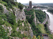
At this point the A4 regains Trunk Road classification and passes under the Clifton Suspension Bridge
along the Portway
. It heads out of the city into the suburbs of Sea Mills
and Shirehampton
before going under the M5
to end at the roundabout that feeds the motorway, the M49
and A403
in Avonmouth
.
England
England is a country that is part of the United Kingdom. It shares land borders with Scotland to the north and Wales to the west; the Irish Sea is to the north west, the Celtic Sea to the south west, with the North Sea to the east and the English Channel to the south separating it from continental...
, portions of which are known as the Great West Road and Bath Road. It runs from London
London
London is the capital city of :England and the :United Kingdom, the largest metropolitan area in the United Kingdom, and the largest urban zone in the European Union by most measures. Located on the River Thames, London has been a major settlement for two millennia, its history going back to its...
to Avonmouth
Avonmouth
Avonmouth is a port and suburb of Bristol, England, located on the Severn Estuary, at the mouth of the River Avon.The council ward of Avonmouth also includes Shirehampton and the western end of Lawrence Weston.- Geography :...
, near Bristol
Bristol
Bristol is a city, unitary authority area and ceremonial county in South West England, with an estimated population of 433,100 for the unitary authority in 2009, and a surrounding Larger Urban Zone with an estimated 1,070,000 residents in 2007...
. Historically the road was the main route from London to the west of England, and has formed the second main western artery from London
London
London is the capital city of :England and the :United Kingdom, the largest metropolitan area in the United Kingdom, and the largest urban zone in the European Union by most measures. Located on the River Thames, London has been a major settlement for two millennia, its history going back to its...
, after Western Avenue A40
A40 road
The A40 is a major trunk road connecting London to Fishguard, Wales and officially called The London to Fishguard Trunk Road in all legal documents and Acts...
. Much of the route is now paralleled by the M4 motorway
M4 motorway
The M4 motorway links London with South Wales. It is part of the unsigned European route E30. Other major places directly accessible from M4 junctions are Reading, Swindon, Bristol, Newport, Cardiff and Swansea...
, which carries the bulk of long distance traffic in this corridor, leaving the A4 primarily for local traffic.
Turnpikes
The A4 has gone through many transformations through the ages from following pre-Roman Ley Lines, Roman road building and very basic wagon tracks. During the Middle Ages, most byways and tracks served to connect villages with their nearest market town. A survey of Savernake Forest near Hungerford in 1228 mentions “The King’s Street” running between the town and Marlborough. This street corresponded roughly with the route of the modern A4. In 1632, Thomas WitheringsThomas Witherings
Thomas Witherings was an English merchant and postal administrator who established the Royal Mail public letter service. He was a politician who sat in the House of Commons in 1640.-Early life:...
was appointed Postmaster of Foreign Mails by Charles I. Three years later, the king charged him with building six “Great Roads” to aid in the delivery of the post, of which the Great West Road was one. It was not until the 17th century that a distinct route between London
London
London is the capital city of :England and the :United Kingdom, the largest metropolitan area in the United Kingdom, and the largest urban zone in the European Union by most measures. Located on the River Thames, London has been a major settlement for two millennia, its history going back to its...
and Bristol
Bristol
Bristol is a city, unitary authority area and ceremonial county in South West England, with an estimated population of 433,100 for the unitary authority in 2009, and a surrounding Larger Urban Zone with an estimated 1,070,000 residents in 2007...
started to resemble today's road.
During the 17th century, the A4 was known as the Great Road to Bristol. When Queen Anne
Anne of Great Britain
Anne ascended the thrones of England, Scotland and Ireland on 8 March 1702. On 1 May 1707, under the Act of Union, two of her realms, England and Scotland, were united as a single sovereign state, the Kingdom of Great Britain.Anne's Catholic father, James II and VII, was deposed during the...
started patronising the spa city of Bath, the road became more commonly known as Bath Road. Over the years, the direction of the road has taken many detours depending on such factors as changes in tolls or turnpike patronage. For example, in 1750 the toll road from London was altered to go through Melksham
Melksham
Melksham is a medium-sized English town, lying on the River Avon. It lies in the county of Wiltshire.It is situated southeast of the city of Bath, south of Chippenham, west of Devizes and north of Warminster on the A350 national route. The 2001 UK census cited Melksham as having 20,000...
and in 1695 the map maker, John Ogilby, produced a map of the Hungerford area of the Great West Road showing two possible routes.
As Bath became more popular with the wealthy and famous, it was inevitable that Turnpike Trusts would be set up under the terms of the Turnpike Acts to pay for maintenance and improvements to the road. The first Turnpike on this road was between Reading
Reading, Berkshire
Reading is a large town and unitary authority area in England. It is located in the Thames Valley at the confluence of the River Thames and River Kennet, and on both the Great Western Main Line railway and the M4 motorway, some west of London....
and Theale
Theale, Berkshire
Theale is a large village and civil parish in the English county of Berkshire. The village has many of the attributes of a small town, with a high street lined with shops, pubs and restaurants.- Location :...
in 1714. Due to increasing traffic, sections of the road between Kensington
Kensington
Kensington is a district of west and central London, England within the Royal Borough of Kensington and Chelsea. An affluent and densely-populated area, its commercial heart is Kensington High Street, and it contains the well-known museum district of South Kensington.To the north, Kensington is...
, over Hounslow Hill, to Twyford
Twyford, Berkshire
For other places of the same name, see Twyford.Twyford is a village and civil parish in the English Royal county of Berkshire. It is situated, at , in the heart of the Thames Valley on the A4 between Reading and Maidenhead, close to Henley-on-Thames and Wokingham.-History:The town's name is...
were turnpike by 1717 with the remaining sections placed under Turnpike Trusts.
As Turnpike Trusts were individually run, there was the possibility for greatly differing road conditions, especially over the London Clay
London Clay
The London Clay Formation is a marine geological formation of Ypresian age which crops out in the southeast of England. The London Clay is well known for the fossils it contains. The fossils from the Lower Eocene indicate a moderately warm climate, the flora being tropical or subtropical...
basin of Kensington
Kensington
Kensington is a district of west and central London, England within the Royal Borough of Kensington and Chelsea. An affluent and densely-populated area, its commercial heart is Kensington High Street, and it contains the well-known museum district of South Kensington.To the north, Kensington is...
, Brentford
Brentford
Brentford is a suburban town in west London, England, and part of the London Borough of Hounslow. It is located at the confluence of the River Thames and the River Brent, west-southwest of Charing Cross. Its former ceremonial county was Middlesex.-Toponymy:...
, Hounslow
Hounslow
Hounslow is the principal town in the London Borough of Hounslow. It is a suburban development situated 10.6 miles west south-west of Charing Cross. It forms a post town in the TW postcode area.-Etymology:...
and Slough
Slough
Slough is a borough and unitary authority within the ceremonial county of Royal Berkshire, England. The town straddles the A4 Bath Road and the Great Western Main Line, west of central London...
, where winter conditions left the way muddy and uneven. This was not always the case with the Bath Road, as many of the wealthy landowners along the route co-operated informally and exercised a large amount of control over feeder roads. As a result, control of the Bath Road was easy to maintain and many inns and towns became prosperous.
Tollhouses were established at Colnbrook
Colnbrook
Colnbrook is a large village in the unitary authority of Slough, in Berkshire, England. It is situated southeast of central Slough, east of Windsor and west of central London....
, Maidenhead
Maidenhead
Maidenhead is a town and unparished area within the Royal Borough of Windsor and Maidenhead, in Berkshire, England. It lies on the River Thames and is situated west of Charing Cross in London.-History:...
, Twyford
Twyford, Berkshire
For other places of the same name, see Twyford.Twyford is a village and civil parish in the English Royal county of Berkshire. It is situated, at , in the heart of the Thames Valley on the A4 between Reading and Maidenhead, close to Henley-on-Thames and Wokingham.-History:The town's name is...
, Castle Street Reading
Reading, Berkshire
Reading is a large town and unitary authority area in England. It is located in the Thames Valley at the confluence of the River Thames and River Kennet, and on both the Great Western Main Line railway and the M4 motorway, some west of London....
, Thatcham and Benham
Benham Park
Benham Park is a mansion in the English county of Berkshire, within the civil parish of Speen. It is located west of Newbury, not far off the A34, near the village of Marsh Benham....
. During the 1820s the employment of good surveyors improved the condition of the road and aided in the increase flow of wealthy travellers. The tolls raised from such clientele ensured that when the Turnpike Trusts handed over the route to local Highway Boards, they had no financial liabilities. Justices of the Peace were empowered by the 1862 Rural Highways Act to combine turnpike trusts into Highways Districts. This meant that by the late 1860s trusts were either not renewing their powers or were being terminated by General Acts of Parliament. For example, most turnpikes in Berkshire, including the Bath Road, were officially wound up by 1878 when legislation transferred responsibility for dis-enturnpiked roads to the new County Councils. The tollgate on the Bath Road west of Reading was removed in 1864 as the outward pressure of urban development made rates a more acceptable way of financing the maintenance of what was now a sub-urban road.
Postal service and coaching
With the improvement being made to the road systems, the business of moving mail became easier and thus more profitable as volumes were able to increase. In Bristol, a postal office had been well established by the 1670s. The journey time to London at this period was about 16 and three quarter hours. A letter from Bath in 1684 took about 3 days going via a postal office in MarshfieldMarshfield, Gloucestershire
Marshfield is a village in the local government area of South Gloucestershire, England, on the borders of the counties of Wiltshire and Somerset.- Location :...
on the Bristol Road. The route to Bristol did not yet go through Bath at this time. Journey times during the Turnpike era fell with the improvements from 2 days in 1752 to 38 hours in 1782 and 18 hours by 1836. Royal Mail coaches in 1836 were able to do the trip in 12–13 hours.
Further improvements to regional post services were made between 1719 and 1763 due to contracts with the London Inland Letter Office negotiated by Ralph Allen
Ralph Allen
Ralph Allen was an entrepreneur and philanthropist, and was notable for his reforms to the British postal system. He was baptised at St Columb Major, Cornwall on 24 July 1693. As a teenager he worked at the Post Office. He moved in 1710 to Bath, where he became a post office clerk, and at the age...
, the postmaster of Bath.
In the early part of the 19th century, Coaching was at its height with six stagecoaches each day carrying passengers to and from London along the Bath Road in 1830 rising to 10 by 1836. Hungerford was almost at the midway point of the journey between London and Bristol and was ideally positioned to take advantage of the increase in Coaching. In 1836, five companies operated a coaching service though Hungerford. This was to be short-lived with the rise of the Railways. For example, the decline in coaching traffic in Hungerford coincided with the building of the Great Western Railway and the Station at Faringdon, 14 miles away, and the subsequent Berks and Hants Railway line from Newbury to Hungerford itself in 1847. By 1843 it was reported that the last coach had ceased running between Bristol and London.
Holborn Circus to Westminster (0.4 Miles)
The A4 begins as New Fetter Lane in the City of LondonCity of London
The City of London is a small area within Greater London, England. It is the historic core of London around which the modern conurbation grew and has held city status since time immemorial. The City’s boundaries have remained almost unchanged since the Middle Ages, and it is now only a tiny part of...
at Holborn Circus
Holborn Circus
Holborn Circus is a famous location in London, on the boundary between Holborn and Smithfield. Holborn Circus is a roundabout.On one side lies the Church of St Andrew, Holborn, an ancient Guild Church, that survived the Great Fire of London. However, the parochial authority decided, nevertheless,...
on the A40
A40 road
The A40 is a major trunk road connecting London to Fishguard, Wales and officially called The London to Fishguard Trunk Road in all legal documents and Acts...
. It goes in a southerly direction to join Fleet Street
Fleet Street
Fleet Street is a street in central London, United Kingdom, named after the River Fleet, a stream that now flows underground. It was the home of the British press until the 1980s...
where many British national newspapers at one time had their head offices. Most of these are now home to law firms.The Office of Fair Trading
Office of Fair Trading
The Office of Fair Trading is a not-for-profit and non-ministerial government department of the United Kingdom, established by the Fair Trading Act 1973, which enforces both consumer protection and competition law, acting as the UK's economic regulator...
has its main office here.
Westminster to Hammersmith via Kensington (4.6 Miles)
The road heads west through the City of Westminster via the StrandStrand, London
Strand is a street in the City of Westminster, London, England. The street is just over three-quarters of a mile long. It currently starts at Trafalgar Square and runs east to join Fleet Street at Temple Bar, which marks the boundary of the City of London at this point, though its historical length...
, passing notable landmarks such as The Adelphi Theatre, The Savoy Theatre and the Royal Courts of Justice
Royal Courts of Justice
The Royal Courts of Justice, commonly called the Law Courts, is the building in London which houses the Court of Appeal of England and Wales and the High Court of Justice of England and Wales...
, before reaching Charing Cross railway station
Charing Cross railway station
Charing Cross railway station, also known as London Charing Cross, is a central London railway terminus in the City of Westminster, England. It is one of 18 stations managed by Network Rail, and trains serving it are operated by Southeastern...
. When travelling east, the A4 follows the one way system down Duncannon Street as the Bus Lane from Trafalgar Square
Trafalgar Square
Trafalgar Square is a public space and tourist attraction in central London, England, United Kingdom. At its centre is Nelson's Column, which is guarded by four lion statues at its base. There are a number of statues and sculptures in the square, with one plinth displaying changing pieces of...
to Charing Cross station prevents travel in that direction by other road users.
The A4 continues west to Trafalgar Square
Trafalgar Square
Trafalgar Square is a public space and tourist attraction in central London, England, United Kingdom. At its centre is Nelson's Column, which is guarded by four lion statues at its base. There are a number of statues and sculptures in the square, with one plinth displaying changing pieces of...
, where The National Gallery, Canada House
Canada House
The High Commission of Canada in the United Kingdom in London is the diplomatic mission from Canada to the United Kingdom. It is housed in two buildings in London.-History:...
and South Africa House
South Africa House
The High Commission of South Africa in London is the diplomatic mission from South Africa to the United Kingdom. It is located at South Africa House, a building on Trafalgar Square, London...
are located, and then to Cockspur Street, before taking a left turn into Pall Mall
Pall Mall, London
Pall Mall is a street in the City of Westminster, London, and parallel to The Mall, from St. James's Street across Waterloo Place to the Haymarket; while Pall Mall East continues into Trafalgar Square. The street is a major thoroughfare in the St James's area of London, and a section of the...
. This road was named after a mallet and ball game played in the parks nearby. Pall Mall is notable as the location of the many exclusive Gentlemen's Clubs as well as the Institute of Directors
Institute of Directors
The Institute of Directors is a UK-based organisation, established in 1903 and incorporated by royal charter in 1906 to support, represent and set standards for company directors...
.
The road takes a right turn heading northwards along St James's Street before turning westward again into Piccadilly
Piccadilly
Piccadilly is a major street in central London, running from Hyde Park Corner in the west to Piccadilly Circus in the east. It is completely within the city of Westminster. The street is part of the A4 road, London's second most important western artery. St...
and passing Green Park
Green Park
-External links:*...
on the left. If travelling eastwards, the A4 covers the full length of Piccadilly to Piccadilly Circus
Piccadilly Circus
Piccadilly Circus is a road junction and public space of London's West End in the City of Westminster, built in 1819 to connect Regent Street with the major shopping street of Piccadilly...
before turning southwards into Haymarket to complete the one-way system.
A short tunnel takes the route under Hyde Park Corner
Hyde Park Corner
Hyde Park Corner is a place in London, at the south-east corner of Hyde Park. It is a major intersection where Park Lane, Knightsbridge, Piccadilly, Grosvenor Place and Constitution Hill converge...
where Constitution Arch is found. On emerging from the tunnel, the road goes from Knightsbridge Green into Knightsbridge
Knightsbridge
Knightsbridge is a road which gives its name to an exclusive district lying to the west of central London. The road runs along the south side of Hyde Park, west from Hyde Park Corner, spanning the City of Westminster and the Royal Borough of Kensington and Chelsea...
itself. This is an affluent area of London
London
London is the capital city of :England and the :United Kingdom, the largest metropolitan area in the United Kingdom, and the largest urban zone in the European Union by most measures. Located on the River Thames, London has been a major settlement for two millennia, its history going back to its...
and the notable shops of Harrods and Harvey Nichols are located here.
The start of Brompton Road marks the boundary of the City of Westminster and entrance to The Royal Borough of Kensington and Chelsea
Royal Borough of Kensington and Chelsea
The Royal Borough of Kensington and Chelsea is a central London borough of Royal borough status. After the City of Westminster, it is the wealthiest borough in England....
. The road continues west to Thurloe Place past the Victoria & Albert Museum and Ismaili Centre, London
Ismaili Centre, London
The Ismaili Centre, London is one of five such centres world-wide. Established in South Kensington more than a quarter of a century ago, it is a religious, social and cultural meeting place for the Ismaili Muslim community in the United Kingdom and is the first such centre to be specially designed...
. It continues into Cromwell Gardens and Cromwell Road where the Natural History Museum
Natural History Museum
The Natural History Museum is one of three large museums on Exhibition Road, South Kensington, London, England . Its main frontage is on Cromwell Road...
is situated. Cromwell Road continues for approximately 1.7 miles before passing into the Borough of Hammersmith marked by the exposed London Underground tracks near Earl’s Court Exhibition Centre.
Hammersmith to Heathrow Airport (10.7 Miles)
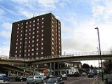
The A4 continues along Talgarth Road past the London Academy of Music and Dramatic Art. The road becomes elevated at the Hammersmith FlyoverHammersmith Flyover
Hammersmith Flyover is an elevated roadway in west London which carries the A4 arterial road over and to one side of the central Hammersmith gyratory system, and it links together the Cromwell Road extension with the start of the Great West Road.It was one of the first examples of an elevated road...
and heads towards Heathrow Airport along the Great West Road.
At this point the road is close to the River Thames
River Thames
The River Thames flows through southern England. It is the longest river entirely in England and the second longest in the United Kingdom. While it is best known because its lower reaches flow through central London, the river flows alongside several other towns and cities, including Oxford,...
as it passes though the Borough of Chiswick
Chiswick
Chiswick is a large suburb of west London, England and part of the London Borough of Hounslow. It is located on a meander of the River Thames, west of Charing Cross and is one of 35 major centres identified in the London Plan. It was historically an ancient parish in the county of Middlesex, with...
and crosses over the River Brent
River Brent
The Brent is a river within Greater London which is a tributary of the River Thames. It is 17.9 miles long, running north-east to south-west, and it joins the Thames on the Tideway at Brentford, Hounslow.- Hydronymy and etymology :...
before the A4 follows underneath its successor the M4 as far as the Glaxo-Smith Kline premises in Brentford
Brentford
Brentford is a suburban town in west London, England, and part of the London Borough of Hounslow. It is located at the confluence of the River Thames and the River Brent, west-southwest of Charing Cross. Its former ceremonial county was Middlesex.-Toponymy:...
. It remains as the Great West Road through Hounslow
Hounslow
Hounslow is the principal town in the London Borough of Hounslow. It is a suburban development situated 10.6 miles west south-west of Charing Cross. It forms a post town in the TW postcode area.-Etymology:...
where it splits with the A30, which is known as the Great South West Road. Between the two world wars, the Great West Road was built as a bypass to relieve traffic congestion in Brentford and Hounslow. Here it passes along the northern boundary of Heathrow Airport, before leaving the London suburbs over the M25 towards the West.
Heathrow Airport to Slough (6.7 Miles)
After leaving Heathrow Airport, still the A4, it becomes the Colnbrook Bypass and climbs over the M25 motorway. This bypass for the narrow main road of ColnbrookColnbrook
Colnbrook is a large village in the unitary authority of Slough, in Berkshire, England. It is situated southeast of central Slough, east of Windsor and west of central London....
was built after the Second World War across farmland between Harmondsworth and the outskirts of Langley.
Grundon's massive incinerator, one of the largest in Europe, is on the right.
The next major intersection is junction 5 of the M4 (Slough-East) known as the Langley junction. At this point the A4 loses its Trunk Road
Trunk road
A trunk road, trunk highway, or strategic road is a major road—usually connecting two or more cities, ports, airports, and other things.—which is the recommended route for long-distance and freight traffic...
classification.
Continuing towards Slough
Slough
Slough is a borough and unitary authority within the ceremonial county of Royal Berkshire, England. The town straddles the A4 Bath Road and the Great Western Main Line, west of central London...
town centre, the road, now named London Road, passes Kedermister Park on the right. Changing into Sussex Place, the architecturally impressive St Bernard's former convent is on the right. Becoming the dual carriageway Wellington Street (a late 1960s bypass for the High Street), Tesco's massive 'aircraft hanger' supermarket is on the right and the Queensmere and Observatory Shopping Centres on the left.
The end of this section of the Great Western Road is in the centre of Slough
Slough
Slough is a borough and unitary authority within the ceremonial county of Royal Berkshire, England. The town straddles the A4 Bath Road and the Great Western Main Line, west of central London...
at the junction of William Street and Wellington Street. This spot was formerly the site of Slough's largest roundabout on the south-east corner of Thames Valley University. Nearby is Slough railway station
Slough railway station
Slough railway station, in Slough, Berkshire, England, is served by local services operated by First Great Western from to and intercity services on the Great Western Main Line, the original line of the Great Western Railway...
, serviced by First Great Western.
The roundabout was removed in 2011 and the university's Slough campus closed in 2011 after planning permission was granted for 1,598 flats. Abandoning Slough, the university renamed itself University of West London.
Slough to Maidenhead (6.0 Miles)
Continuing from William Street / Wellington Street junction, in the centre of SloughSlough
Slough is a borough and unitary authority within the ceremonial county of Royal Berkshire, England. The town straddles the A4 Bath Road and the Great Western Main Line, west of central London...
, the road heads westwards towards Maidenhead. The short stretch of dual carriageway is Wellington Street, then briefly on the most western end of the High Street, over the railway bridge for the line between Slough and Windsor
Windsor, Berkshire
Windsor is an affluent suburban town and unparished area in the Royal Borough of Windsor and Maidenhead in Berkshire, England. It is widely known as the site of Windsor Castle, one of the official residences of the British Royal Family....
Central Station.
The Bath Road begins on the west side of the bridge. On the left is Slough's 1936 Town Hall, now abandoned by the local council, and on the right Salt Hill Park.
The next major road intersection is by the Tree Tuns Pub where the A4 cross the A355. North goes towards Farnham Royal, Farnham Common, Beaconsfield and the M40
M40 motorway
The M40 motorway is a motorway in the British transport network that forms a major part of the connection between London and Birmingham. Part of this road forms a section of the unsigned European route E05...
junction 2. South goes towards the M4
M4 motorway
The M4 motorway links London with South Wales. It is part of the unsigned European route E30. Other major places directly accessible from M4 junctions are Reading, Swindon, Bristol, Newport, Cardiff and Swansea...
(junction 6, Slough Centre) and Windsor
Windsor, Berkshire
Windsor is an affluent suburban town and unparished area in the Royal Borough of Windsor and Maidenhead in Berkshire, England. It is widely known as the site of Windsor Castle, one of the official residences of the British Royal Family....
.
The route at this point is paralleling both the London to Bristol main line railway and the M4. The road continues pass the southern fringe of Slough Trading Estate; once the biggest in Europe.
The next major intersection is on Slough's western boundary at the Huntercombe Spur roundabout linking to junction 7 of the M4 motorway. Here the dual carriageway ends. Up ahead the road bends right and passes under a high railway bridge, then over the River Thames flood prevention channel which is almost unnoticeable.
Then over Maidenhead's old bridge Maidenhead Bridge
Maidenhead Bridge
Maidenhead Bridge is a Grade I listed bridge carrying the A4 road over the River Thames between Maidenhead, Berkshire and Taplow, Buckinghamshire, England. It crosses the Thames on the reach above Bray Lock, about half a mile below Boulter's Lock.-History:...
, spanning the River Thames
River Thames
The River Thames flows through southern England. It is the longest river entirely in England and the second longest in the United Kingdom. While it is best known because its lower reaches flow through central London, the river flows alongside several other towns and cities, including Oxford,...
, and into the eastern outskirts of Maidenhead.
Along Bridge Road, St Cloud Way and Bad Godesberg Way respectively. The centre of Maidenhead is reached at the roundabout that forms the Junction with the A308
A308 road
The A308, is a road in England in two parts.*The Brompton to Fulham section starts at the A4 road by Brompton Oratory and Victoria and Albert Museum, and follows Fulham Road South West to Chelsea and Westminster Hospital, where it jumps south a block to follow Kings Road to meet the A219 road in...
. Turning northwards on the A308 would lead to the A404
A404 road
The A404 is a road in the United Kingdom that starts at Paddington in London and leads to Maidenhead in Berkshire.The road initially follows a course through London and its suburbs including Harlesden, Wembley, Harrow Pinner, and Rickmansworth...
towards Marlow
Marlow, Buckinghamshire
Marlow is a town and civil parish within Wycombe district in south Buckinghamshire, England...
and High Wycombe
High Wycombe
High Wycombe , commonly known as Wycombe and formally called Chepping Wycombe or Chipping Wycombe until 1946,is a large town in Buckinghamshire, England. It is west-north-west of Charing Cross in London; this figure is engraved on the Corn Market building in the centre of the town...
. Southwards, the A308 heads towards Windsor and provides an opportunity to branch off for Junction 8 or 9 of the M4.
Maidenhead to Reading (12.3 Miles)
Heading out of Maidenhead Town Centre, the road follows Castle Hill and then Bath Road. At the outskirts, the road forms part of Junction 9b of the A404(M)/A404, which links Junction 8/9 of the M4 with Junction 4 (Handy Cross) of the M40. The A4 crosses open countryside before following New Bath Road on the outskirts of TwyfordTwyford, Berkshire
For other places of the same name, see Twyford.Twyford is a village and civil parish in the English Royal county of Berkshire. It is situated, at , in the heart of the Thames Valley on the A4 between Reading and Maidenhead, close to Henley-on-Thames and Wokingham.-History:The town's name is...
. This is a bypass, built in 1929, that deviates from the old route of the A4, and crosses the River Loddon
River Loddon
The River Loddon is a river in the English counties of Berkshire and Hampshire. It is a tributary of the River Thames, rising within the urban area of Basingstoke and flowing to meet the Thames near the village of Wargrave...
on its way into the suburbs of Reading
Reading, Berkshire
Reading is a large town and unitary authority area in England. It is located in the Thames Valley at the confluence of the River Thames and River Kennet, and on both the Great Western Main Line railway and the M4 motorway, some west of London....
via the village of Charvil.
The A4 passes the King George's Field in Sonning
Sonning
Sonning, occasionally called Sonning-on-Thames is a village and civil parish in the Borough of Wokingham in the English county of Berkshire, a few miles east of Reading. The village is situated on the River Thames and was described by Jerome K...
, which are used as playing fields, and the Reading Cricket and Hockey Club
Reading Hockey Club
Reading Hockey Club is a field hockey club based at Sonning Lane in the English town of Reading.It is presently one of the most successful clubs in the United Kingdom with National League and Cup honours....
. As it enters Reading, along the London Road again, it crosses the junction of the A329(M) next to Palmer Park
Palmer Park, Reading
Palmer Park is a public park in Reading, England. The land for the park was given to the town in 1889 by the Palmer family, proprietors of the Huntley & Palmers biscuit factory, and contains a statue of George Palmer....
, which leads to Junction 10 of the M4.
The A4 goes over the intersection with the A329
A329 road
The A329 is an east-west road in Southern England that runs from Wentworth in Surrey to Thame in Oxfordshire. The A329 starts at the A30 in Surrey and passes through the towns of Ascot, Bracknell, Wokingham, Earley, Reading, the village of Pangbourne, and Wallingford in Oxfordshire...
Cemetery Junction which links Wokingham
Wokingham
Wokingham is a market town and civil parish in Berkshire in South East England about west of central London. It is about east-southeast of Reading and west of Bracknell. It spans an area of and, according to the 2001 census, has a population of 30,403...
with Pangbourne
Pangbourne
Pangbourne is a large village and civil parish on the River Thames in the English county of Berkshire. Pangbourne is the home of the independent school, Pangbourne College.-Location:...
, passing the Royal Berkshire Hospital and the London Road Campus of the University of Reading. At London Street and again at Southhampton Street, the A4 meets the A327 twice, since the latter loops round on two branches which meet at Whitley Street. Between the two junctions, the A4 becomes Crown Street for approximately 150m.
Reading to Newbury (16.7 Miles)
On the other side of the intersection the A4 follows Pell Street and continues westward. Here it crosses the River KennetRiver Kennet
The Kennet is a river in the south of England, and a tributary of the River Thames. The lower reaches of the river are navigable to river craft and are known as the Kennet Navigation, which, together with the Avon Navigation, the Kennet and Avon Canal and the Thames, links the cities of Bristol...
, the Holy Brook
Holy Brook
The Holy Brook is a channel of the River Kennet in the vicinity of the English town of Reading, Berkshire. While of considerable historical significance, the origin and nature of the brook is still unclear...
and the A33
A33 road
The A33 is a major road in England. The road formerly ran from Reading to Southampton, but now consists of three disjoint sections:*Reading to Basingstoke*The A30 road south of Basingstoke to just north of Winchester...
relief road, which goes towards Basingstoke
Basingstoke
Basingstoke is a town in northeast Hampshire, in south central England. It lies across a valley at the source of the River Loddon. It is southwest of London, northeast of Southampton, southwest of Reading and northeast of the county town, Winchester. In 2008 it had an estimated population of...
. In West Reading
West Reading, Berkshire
West Reading is a district of the town of Reading in the English county of Berkshire.-Geography:The district has no formal boundaries, but the name is generally used to refer to the area to the west of Reading's town centre, to the north of the suburbs of Coley and Southcote, to the east of the...
, the A4 becomes Berkeley Avenue, and then continues onto the Bath Road. It passes Prospect Park
Prospect Park, Reading
Prospect Park is both a public park and a historic house at Tilehurst in the western suburbs of the town of Reading in the English county of Berkshire. It is at .Prospect Park was originally the site of Dirle's Farm and part of the estate of Calcot Park...
, and the suburbs of Southcote
Southcote, Berkshire
Southcote is a suburb and local government ward of Reading in the English county of Berkshire.The suburb of Southcote is bounded to the north by the Bath Road and Prospect Park, to the west by the more recently developed suburb of Fords Farm, to the south by the Holy Brook and the water meadows of...
, Horncastle
Horncastle, Berkshire
Horncastle is an area of the town of Reading, in the English county of Berkshire. It is situated on the A4 Bath Road to the west of central Reading, at a point where the Reading suburbs of Southcote, Calcot and Tilehurst all meet, and is designated as a conservation area.Today largely surrounded on...
and Calcot, before reaching Junction 12 of the M4. The A4 heads south westerly through Theale
Theale, Berkshire
Theale is a large village and civil parish in the English county of Berkshire. The village has many of the attributes of a small town, with a high street lined with shops, pubs and restaurants.- Location :...
and over the roundabout connecting it to the A340
A340 road
The A340 is a major road in the south of England, portions of which are known as the Aldermaston Road, Tadley Hill, Basingstoke Road and Tidmarsh Road.-Route:...
which heads towards Pangbourne.
Heading towards Thatcham, the road passes Aldermaston Wharf
Aldermaston Wharf
Aldermaston Wharf is a small settlement situated north-northwest of Aldermaston in the West Berkshire district, part of the English county of Berkshire. The Kennet and Avon Canal and Great Western Railway pass through it and Aldermaston railway station and Aldermaston Lock are located here. The A4...
next to the Kennet and Avon Canal
Kennet and Avon Canal
The Kennet and Avon Canal is a waterway in southern England with an overall length of , made up of two lengths of navigable river linked by a canal. The name is commonly used to refer to the entire length of the navigation rather than solely to the central canal section...
and through the villages of Woolhampton
Woolhampton
Woolhampton is a village and civil parish in the English county of Berkshire. The village is situated on the London to Bath road between the towns of Reading and Newbury...
and Midgham
Midgham
Midgham is a village and civil parish in the Kennet Valley about east of Newbury, Berkshire. It has a population of 282.The village extends to the Berkshire Arms public house in the west, New Road Hill in the east, Midgham Marsh to the south of the A4 road and Midgham Green to the north...
. A large Industrial Estate is on the left as the road enters Thatcham. At the roundabout after the Industrial Estate the route follows London Road and passes Thatcham
Thatcham
Thatcham is a town in Berkshire, England 3 miles east of Newbury and 15 miles west of Reading. It covers about and has a population of 23,000 people . This number has grown rapidly over the last few decades from 5,000 in 1951 and 7,500 in 1961.It lies on the River Kennet, the Kennet and Avon...
towards Benham Hill and Newbury
Newbury, Berkshire
Newbury is a civil parish and the principal town in the west of the county of Berkshire in England. It is situated on the River Kennet and the Kennet and Avon Canal, and has a town centre containing many 17th century buildings. Newbury is best known for its racecourse and the adjoining former USAF...
. At the Benham Hill roundabout it goes along Bath Road where it deviates from the old Turnpike Road (still named as such), and then along London Road as it enters the outskirts of Newbury.
Heading towards the centre of Newbury, the route passes the West Berkshire Community Hospital
West Berkshire Community Hospital
West Berkshire Community Hospital is a small hospital in West Berkshire, England. The complex opened on 1 March 2004 to replace the services previously provided by Newbury and Sandleford hospitals....
on the right. To the North of the town centre the road becomes part of an unusual junction with the A339
A339 road
The A339 is a long A road in England. It is the main road between Newbury in Berkshire and Alton in Hampshire.-Points of interest:...
that links the new A34
A34 road
The A34 is a major road in England. It runs from the A6042 in Salford to Winchester in Hampshire. It forms a large part of the major trunk route from Southampton, via Oxford, to Birmingham, The Potteries and Manchester...
by-pass to the North with Basingstoke
Basingstoke
Basingstoke is a town in northeast Hampshire, in south central England. It lies across a valley at the source of the River Loddon. It is southwest of London, northeast of Southampton, southwest of Reading and northeast of the county town, Winchester. In 2008 it had an estimated population of...
to the South. The Junction is a combination of a figure of eight roundabout with an elevated section that used to be the old route of the A34.
Newbury to Marlborough (18.8 Miles)
After the junction, the road heads out of town though Speenhamland along Western Avenue and Bath Road to the junction with the A34 Newbury bypassNewbury bypass
The Newbury bypass, officially known as The Winchester-Preston Trunk Road , is a stretch of dual carriageway road which bypasses the town of Newbury in Berkshire, England...
. The Newbury bypass was opened, after lengthy controversy, on 17 November 1998 at a cost of £104M. The route heads over undulating countryside in a fairly straight westward direction towards Hungerford
Hungerford
Hungerford is a market town and civil parish in Berkshire, England, 9 miles west of Newbury. It covers an area of and, according to the 2001 census, has a population of 5,559 .- Geography :...
parallel to the Kennet and Avon Canal and crossing the River Kennet on the outskirts of the town at the same time as intersecting with the A338
A338 road
The A338 is a major trunk road in southern England, that runs from the junction with the A35 at Bournemouth in Dorset to the junction with the A420 at Besselsleigh in Oxfordshire, roughly long.-Route:...
. The route does not enter the town centre, but continues westward to the northern side of town on its way to Marlborough via the village of Froxfield and the Northern edge of Savernake Forest
Savernake Forest
Savernake Forest is on a Cretaceous chalk plateau between Marlborough and Great Bedwyn in Wiltshire, England. Its area is approximately .It is privately owned by the Trustees of Savernake Estate, the Earl of Cardigan, and his family solicitor. Since 1939 the running of the forest has been...
.
On entering the outskirts of Marlborough the road follows London Road. Crossing the River Kennet again it briefly shares the highway with the A346 which connects northwards to Swindon
Swindon
Swindon is a large town within the borough of Swindon and ceremonial county of Wiltshire, in South West England. It is midway between Bristol, west and Reading, east. London is east...
. It splits again at a roundabout along New Road and Oxford Street into the affluent Town Centre on the High Street. The High Street is a traditional main thoroughfare for an English Market Town, in that it is wide, with space for Market stalls on either side and in the middle, though these spaces are usually marked for car parking.
Marlborough to Chippenham (18.9 Miles)
The A4 continues along the High Street on its way out of Marlborough via Bridewell Street and Bath Road. The road passes underneath a covered bridge that links Morris House of Marlborough CollegeMarlborough College
Marlborough College is a British co-educational independent school for day and boarding pupils, located in Marlborough, Wiltshire.Founded in 1843 for the education of the sons of Church of England clergy, the school now accepts both boys and girls of all beliefs. Currently there are just over 800...
to the North Block of the same establishment. The college is an independent boarding school established in 1843 using some of the buildings that remained after the demise the Coaching trade, which saw the original Castle Inn Coaching House close.
The route continues westward through the village of Fyfield
Fyfield, Wiltshire
Fyfield is a village in the English county of Wiltshire.-Local government:Fyfield forms part of the civil parish of Fyfield and West Overton, which has an elected parish council...
, across Overton Hill
Overton Hill
Overton Hill is a 571 ft hill at the southern edge of the Marlborough Downs in Wiltshire, England. It is situated just west of the village of West Overton and 4.5 miles from the town of Marlborough, on the A4 Road....
where there is a parking area at the start of the Ridgeway National Trail and through the village of West Kennet. On leaving West Kennet there are some parking lay-bys where visitors can walk a short distance from the road to the Neolithic West Kennet Long Barrow
West Kennet Long Barrow
The West Kennet Long Barrow is a Neolithic tomb or barrow, situated on a prominent chalk ridge, near Silbury Hill, one-and-a-half miles south of Avebury in Wiltshire, England. The site was recorded by John Aubrey in the 17th century and by William Stukeley in the 18th century.Archaeologists...
, which forms part of the Avebury World Heritage Site. One mile further along the A4 is Silbury Hill
Silbury Hill
Silbury Hill is a prehistoric artificial chalk mound near Avebury in the English county of Wiltshire. It is part of the Stonehenge, Avebury and Associated Sites UNESCO World Heritage Site, and lies at ....
, which is also part of the Avebury World Heritage Site. A purpose built Car Park is located beyond the hill on the right travelling westward.
As the route approaches the roundabout that forms the intersection with the A361
A361 road
The A361 is a major road in England and at is the longest 3 digit A road in the UK. It runs south from Ilfracombe on the north Devon coast to Barnstaple, turning south-east to Tiverton then, after a break , north east from Taunton in Somerset through Street and Glastonbury, past Frome and then...
, it passes by the Waggon & Horses Inn, built in 1669 to profit from the increasing trade along the old Bath Road. It is mentioned in The Pickwick Papers
The Pickwick Papers
The Posthumous Papers of the Pickwick Club is the first novel by Charles Dickens. After the publication, the widow of the illustrator Robert Seymour claimed that the idea for the novel was originally her husband's; however, in his preface to the 1867 edition, Dickens strenuously denied any...
novel by Charles Dickens
Charles Dickens
Charles John Huffam Dickens was an English novelist, generally considered the greatest of the Victorian period. Dickens enjoyed a wider popularity and fame than had any previous author during his lifetime, and he remains popular, having been responsible for some of English literature's most iconic...
.
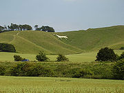
Cherhill White Horse
The Cherhill White Horse is a hill figure on Cherhill Down, 3.5 miles east of Calne in Wiltshire, England. Dating from the late 18th century, it is the third oldest of several such white horses in Great Britain, with only the Uffington White Horse and the Westbury White Horse being older...
can be seen to the left and nearby the Lansdowne Monument
Lansdowne Monument
The Lansdowne Monument, also known as Cherhill Monument, near Cherhill in Wiltshire is a 38 metre stone obelisk erected by Third Marquis of Lansdowne to the designs of Sir Charles Barry to commemorate his ancestor, Sir William Petty in 1845....
. The route then descends down the Labour In Vain Hill through the village of Quemerford and into the market town of Calne
Calne
Calne is a town in Wiltshire, southwestern England. It is situated at the northwestern extremity of the North Wessex Downs hill range, a designated Area of Outstanding Natural Beauty....
.
Heading towards the town centre, the road crosses a double mini roundabout, one exit forming the junction with the A3102 to Melksham. It follows New Road and passes by the old Coaching Inn of the Lansdowne Strand. On the way out of Calne, the road goes along Curzon Street, and then to Chilvester Hill at the roundabout where the northern part of the A3102 splits off towards Lyneham
Lyneham, Wiltshire
Lyneham is a large village in north Wiltshire, within the civil parish of Lyneham and Bradenstoke, and situated southwest of Wootton Bassett, north of Calne and southwest of Swindon. The village is on the A3102 road between Calne and Wootton Bassett.-RAF Lyneham:RAF Lyneham is at Lyneham...
.
The A4 descends steeply before climbing again up Black Dog Hill past the Bowood House
Bowood House
Bowood is a grade I listed Georgian country house with interiors by Robert Adam and a garden designed by Lancelot "Capability" Brown. It is adjacent to the village of Derry Hill, halfway between Calne and Chippenham in Wiltshire, England...
Estate. The old road used to pass through Derry Hill
Derry Hill
Derry Hill is a village in the English county of Wiltshire, belonging to the civil parish of Calne Without.-Geography:Derry Hill is located to the south of the A4 road, east of Chippenham and to the west of Calne...
, but the New Road, as it is called at this point, indicates that the village was bypassed. There follows a steep descent to the junction with the A342
A342 road
The A342 is an A road that runs from Pewsham near Chippenham, Wiltshire to Andover, Hampshire.The road begins at the A4 junction just outside of the small village Pewsham, to the east of Chippenham. It heads south past the village of Derry Hill towards Devizes, briefly meeting with the A3102 near...
Devizes
Devizes
Devizes is a market town and civil parish in Wiltshire, England. The town is about southeast of Chippenham and about east of Trowbridge.Devizes serves as a centre for banks, solicitors and shops, with a large open market place where a market is held once a week...
road and a sharp right turn past the Lysley Arms towards Chippenham
Chippenham
Chippenham may be:* Chippenham, Wiltshire* Chippenham * Chippenham, Cambridgeshire-See also:* Virginia State Route 150, also known as Chippenham Parkway, USA* Cippenham, Berkshire, UK...
.
On the outskirts of Chippenham is a large roundabout, where most traffic turns left to go round the Pewsham Estate relief road called Pewsham Way, rather than down the more congested and narrower London road which is still classified as the A4. At the end of London road, the A4 turns left in a southerly direction at a roundabout, past the Chippenham Magistrates Court to rejoin Pewsham Way at another roundabout. The old Bath Road continued at the first roundabout and down The Causeway and into the town centre, but this has been pedestrianised. The route heads downhill over the River Avon on the Avenue La Fleche
La Flèche
La Flèche is a municipality located in the French department of Sarthe and the region of Pays de la Loire in the Loire Valley. This is the sub-prefecture of the South-Sarthe, the chief district and the chief city of a canton. This is the second most populous city of the department. The city is part...
, named after one of Chippenham’s twin towns, to the Bridge Centre roundabout.
Chippenham to Bath (12.7 Miles)
The Bridge Centre roundabout forms a junction of the A4 with the A420A420 road
The A420 is a road between Bristol and Oxford in England. Between Swindon and Oxford it is a primary route.-Present route:Since the opening of the M4 motorway, the road is in two sections. The first section begins on Old Market Street near the centre of Bristol, it passes through Kingswood before...
Bristol Road. The route heads over Rowden Hill past the Chippenham Community Hospital and down to the spot where the Rock Musician Eddie Cochran
Eddie Cochran
Eddie Cochran , was an American rock and roll pioneer who in his brief career had a small but lasting influence on rock music through his guitar playing. Cochran's rockabilly songs, such as "C'mon Everybody", "Somethin' Else", and "Summertime Blues", captured teenage frustration and desire in the...
was killed in a car crash on 17 April 1960. A plaque has been placed there in remembrance.
From there it passes under the railway arch built by Isambard Kingdom Brunel
Isambard Kingdom Brunel
Isambard Kingdom Brunel, FRS , was a British civil engineer who built bridges and dockyards including the construction of the first major British railway, the Great Western Railway; a series of steamships, including the first propeller-driven transatlantic steamship; and numerous important bridges...
in the 1830s and on to its junction with the A350. From this point onwards it regains its Trunk Road
Trunk road
A trunk road, trunk highway, or strategic road is a major road—usually connecting two or more cities, ports, airports, and other things.—which is the recommended route for long-distance and freight traffic...
status and heads up Chequers Hill towards Corsham
Corsham
Corsham is a historic market town and civil parish in north west Wiltshire, England. It is at the south western extreme of the Cotswolds, just off the A4 which was formerly the main turnpike road from London to Bristol, between Bath and Chippenham ....
. The road passes through Pickwick, which used to be a village in its own right. The author Charles Dickens
Charles Dickens
Charles John Huffam Dickens was an English novelist, generally considered the greatest of the Victorian period. Dickens enjoyed a wider popularity and fame than had any previous author during his lifetime, and he remains popular, having been responsible for some of English literature's most iconic...
stayed at the Hare & Hounds Inn and used the village name for the title of his novel The Pickwick Papers
The Pickwick Papers
The Posthumous Papers of the Pickwick Club is the first novel by Charles Dickens. After the publication, the widow of the illustrator Robert Seymour claimed that the idea for the novel was originally her husband's; however, in his preface to the 1867 edition, Dickens strenuously denied any...
.
After a series of roundabouts the A4 continues uphill past an MOD site and then descends steeply to the village of Box. From the road the Box Tunnel
Box Tunnel
Box Tunnel is a railway tunnel in Western England, between Bath and Chippenham, dug through Box Hill, and is one of the most significant structures on the Great Western Main Line...
, built as part of the Great Western Railway
Great Western Railway
The Great Western Railway was a British railway company that linked London with the south-west and west of England and most of Wales. It was founded in 1833, received its enabling Act of Parliament in 1835 and ran its first trains in 1838...
, can be seen clearly. The road bears to the right at the junction with the A365 to Bradford on Avon
Bradford on Avon
Bradford on Avon is a town in west Wiltshire, England with a population of about 9,326. The town's canal, historic buildings, shops, pubs and restaurants make it popular with tourists....
, and criss-crosses with the main railway line as far as the roundabout at Bathford
Bathford
Bathford is a village and civil parish east of Bath, England. The parish, which includes Warleigh has a population of 1,753, and extends over .-History:...
which forms a junction with the A363
A363 road
The A363 is a main road in the United Kingdom, which runs through Bath and North East Somerset and Wiltshire. It provides a link between the small market towns of West Wiltshire and Bath, the M4 westbound, and the M5. It runs from the A4 at Bathford to the A350 at Yarnbrook, running through...
towards Bradford-on-Avon. The road after this roundabout becomes a dual carriageway until the A4 diverts to the left down a slip road, and the remainder becomes the A46
A46 road
The A46 is an A road in England. It starts east of Bath, Somerset and ends in Cleethorpes, North East Lincolnshire, but it does not form a continuous route. Large portions of the old road have been lost, bypassed, or replaced by motorway development...
; this section, the 3 miles (4.8 km) £45 million dual-carriageway Batheaston
Batheaston
Batheaston is a village and civil parish east of Bath, England , on the north bank of the River Avon. The parish has a population of 2,625...
/Swainswick
Swainswick
Swainswick is a small village and civil parish, north east of Bath, on the A46 in the Bath and North East Somerset unitary authority, Somerset, England. The parish has a population of 284...
Bypass, opened in summer 1996, was highly controversial both at planning and at construction stages.
The route enters the outskirts of Bath passing by the training grounds of Bath RFC. After a series of traffic light controlled junctions, the A4 continues straight ahead where it meets the A36
A36 road
The A36 is a trunk road and primary route in England that links the port city of Southampton to the city of Bath. At Bath, the A36 connects with the A4 road to Bristol, thus enabling a road link between the major ports of Southampton and Bristol. Originally, the A36 continued onto Avonmouth, but...
. It passes Hedgemead Park and down The Paragon
The Paragon, Bath
The Paragon in the Walcot area of Bath, Somerset, England is a street of Georgian houses which have been designated as listed buildings. It was designed by Thomas Warr Attwood. It now forms part of the A4.Numbers 1 to 21 are 3 storey houses with mansard roofs...
before crossing into George Street and to Queen Square
Queen Square (Bath)
Queen Square is a square of Georgian houses in the city of Bath, England.Queen Square was the first speculative development by the architect John Wood, the Elder. Wood lived in a house on the square. Numbers 21-27 make up the north side...
.
Bath to Bristol/Avonmouth (19.6 miles)
From Queen Square
Queen Square (Bath)
Queen Square is a square of Georgian houses in the city of Bath, England.Queen Square was the first speculative development by the architect John Wood, the Elder. Wood lived in a house on the square. Numbers 21-27 make up the north side...
the A4 carries on to Queen Square Place and Charlotte Street, before heading along the Upper Bristol Road by Royal Victoria Park to Newbridge Road. The road crosses the River Avon on its way to join the A36 and become a dual carriageway again until the roundabout that forms the junction with the A39
A39 road
The A39 is an A road in south west England. It runs south-west from Bath in Somerset through Wells, Glastonbury, Street and Bridgwater. It then follows the north coast of Somerset and Devon through Williton, Minehead, Porlock, Lynmouth, Barnstaple, Bideford, Stratton, Camelford, Wadebridge and St...
Wells Road. It continues on through the town of Saltford
Saltford
Saltford is a large village and civil parish in the Bath and North East Somerset unitary authority, Somerset, England. It lies between the cities of Bristol and Bath....
towards Keynsham
Keynsham
Keynsham is a town and civil parish between Bristol and Bath in Somerset, south-west England. It has a population of 15,533.It was listed in the Domesday Book as Cainesham, which is believed to mean the home of Saint Keyne....
where a roundabout splits the road and the A4 continues as a dual carriageway by-pass to the town, crossing over the River Chew
River Chew
The River Chew is a small river in England. It merges with the River Avon after forming the Chew Valley.The spring from which the Chew rises is just upstream from Chewton Mendip. The river flows North West from Chewton Mendip through Litton, Chew Valley Lake, Chew Stoke, Chew Magna and Stanton Drew...
in the process.
The end of the by-pass coincides with the junction of the Bristol Outer Ring Road, the A4174
A4174 road
The A4174 is a major road in England which runs around the northern and eastern edge of Bristol, mainly in South Gloucestershire, and through the southern suburbs of Bristol...
. The route goes though the suburb of Brislington, going past Arnos Court Park and Arnos Vale Cemetery
Arnos Vale Cemetery
Arnos Vale Cemetery , located in Arno's Vale in Bristol, England, was established in 1837. Its first burial was in 1839. The cemetery followed a joint-stock model, funded by shareholders. It was laid out as an Arcadian landscape with buildings by Charles Underwood.Arnos Vale cemetery is located on...
. The road runs over a bridge over the New Cut
New Cut (Bristol)
The New Cut is an artificial waterway which was constructed between 1804 and 1809 to divert the tidal river Avon through south and east Bristol, England. This was part of the process of constructing Bristol's Floating Harbour, under the supervision of engineer William Jessop...
and into Temple Gate where Bristol Temple Meads railway station is located. The route turns into Redcliffe Way where it loses Trunk Road classification at the roundabout junction with the A38
A38 road
The A38, part of which is also known as the Devon Expressway, is a major A-class trunk road in England.The road runs from Bodmin in Cornwall to Mansfield in Nottinghamshire. It is long, making it one of the longest A-roads in England. It was formerly known as the Leeds — Exeter Trunk Road,...
. Redcliffe Way crosses the River Avon again before turning right along Welsh Back and left on Baldwin Street to the Centre
The Centre, Bristol
The Centre is a partially pedestrianised public open space in the central area of Bristol, England, created by covering over the River Frome. The northern end of The Centre is a paved area circuited by Colston Avenue; the southern end is separated from this by a major road junction and is a larger...
. From there it turns back towards the Floating Harbour via Anchor Road past the @Bristol Science Museum. After another roundabout the A4 follows along Hotwell Road and around a one-way system that merges the A4 with the A3029.
At this point the A4 regains Trunk Road classification and passes under the Clifton Suspension Bridge
Clifton Suspension Bridge
Brunel died in 1859, without seeing the completion of the bridge. Brunel's colleagues in the Institution of Civil Engineers felt that completion of the Bridge would be a fitting memorial, and started to raise new funds...
along the Portway
Portway, Bristol
The Portway is a trunk road, approximately long, which links central Bristol, England, with its port at Avonmouth. It is part of the A4 road, which was the primary east west highway in Southern England before the construction of the M4 motorway....
. It heads out of the city into the suburbs of Sea Mills
Sea Mills, Bristol
Sea Mills is a suburb of the English port city of Bristol. It is situated some 3.5 miles north-west of the city centre, towards the seaward end of the Avon Gorge. Nearby suburbs are Shirehampton, Sneyd Park, Combe Dingle and Stoke Bishop...
and Shirehampton
Shirehampton
Shirehampton, near Avonmouth, at the north-western edge of the city of Bristol, England, is a district of Bristol which originated as a separate village. It retains something of its village feel, having a short identifiable High Street with the parish church situated among shops, and is still...
before going under the M5
M5 motorway
The M5 is a motorway in England. It runs from a junction with the M6 at West Bromwich near Birmingham to Exeter in Devon. Heading south-west, the M5 runs east of West Bromwich and west of Birmingham through Sandwell Valley...
to end at the roundabout that feeds the motorway, the M49
M49 motorway
The M49 motorway is a 5 mile motorway west of Bristol, England, that forms a shortcut between the M5 motorway and the Second Severn Bridge on the M4 motorway. It was constructed in 1996, at the same time as the bridge and is unique as it is only accessible from other motorways...
and A403
A403 road
The A403 is a road in the United Kingdom that starts at junction 1 of the M48 at Aust and leads to Avonmouth in Bristol. It is important as a major route for the industries there, allowing easy travel access to Wales and South and East England....
in Avonmouth
Avonmouth
Avonmouth is a port and suburb of Bristol, England, located on the Severn Estuary, at the mouth of the River Avon.The council ward of Avonmouth also includes Shirehampton and the western end of Lawrence Weston.- Geography :...
.