
2008 South China floods
Encyclopedia
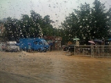
The 2008 South China floods began on 26 May 2008. Four rounds of torrential rains with landslide
s and flooding lasted for 20 days and affected fifteen provinces in Eastern
and Southern China
.
The first round of floods affected twelve provinces in South China
and killed 93 people as of 30 May. A new round of floods began on 6 June and swept nine provinces in southern China killing 55 people with 7 missing and forcing 1.3 million to evacuate as of 14 June. China's National Meteorological Centre has said that heavy rain would continue and that precipitation in the provinces of Guizhou
, Sichuan
and Yunnan
would be 30 to 70% greater than in the same period last year.
provinces
affected include Anhui
, Hunan
, Jiangxi
, Fujian
and Guangdong
.
reported that torrential rains caused by Cloud seeding
in the southern provinces killed 64 people in May. According to State Flood Control and Drought Relief headquarters, floods have claimed 59 lives up to this point of the year.
experienced heavy rainfalls. After 7 days, flood situations were investigated by the China Meteorological Administration
(CMA) on 3 June. The State Flood Control and Drought Relief headquarters and National Meteorological Centre
(NMC) both raised emergency levels expecting more torrential rain and thunderstorms. On the weekend of June 7–8, Guangzhou Daily
reported it to be the heaviest rain storm in 50 years for Guangdong province. Wuzhou
was struck with their worst flooding in 100 years. In two days the rainfall in some areas measured more than 400 millimetres (15.7 inches).
On 14 June, the Ministry of Water Resources
said close to 1 million hectares of farmland have been affected with the worst hit provinces being Guangdong
, Fujian
, Jiangxi
, Hunan
and Hubei
. From 25 May to 14 June, up to 18 people have died, including 2.22 million people were affected in 17 cities in Guangdong. The average rainfall of 415 mm (16.3 in) was double the long-term level, with the media reporting it as "Freak rain".
On 15 June, more than 300 places in Shenzhen
were submerged underwater. Floods have forced more than 1.66 million people to evacuate, caused 67,000 houses to collapse, and killed 63 people. Three days later officials in Guangdong warned of a "black June" as high tide
s, rain and rivers threatened levee
s. Across the region, 169 were reported killed in the floods.
On 21 June, the main precipitation areas include the Huaihe river valleys, Guizhou
, Sichuan
and the middle and lower reaches of the Yangtze River
. Heavy rain follow in Jiangsu
, Anhui
, Henan
, Hubei
, Chongqing
, Sichuan
, Qinghai
, and Inner Mongolia
. At the end of the month, 252 people were killed in the rainstorms and flooding.
and more than 300 mm (11.8 in) fell on Hong Kong island
. By noon, almost 40 landslides and 156 floods were reported. In Tsim Sha Tsui
the 124-year record of rainfall per hour was smashed, with 145.5 mm (5.73 inches) of rainfall being recorded. The North Lantau Highway
was blocked, for the first time since 1997, by a landslide. Land traffic to the village of Tai O
was cut off, forcing the government to increase the frequency of ferries to and from the village. Newspaper vendors in the streets reported that the water came very fast, flooding the area within five minutes to thigh
-deep level. One of the landslides killed two people in Tuen Mun
. The Hong Kong Observatory
thus changed the "amber rainstorm" warning to a "black rainstorm" warning.
Landslide
A landslide or landslip is a geological phenomenon which includes a wide range of ground movement, such as rockfalls, deep failure of slopes and shallow debris flows, which can occur in offshore, coastal and onshore environments...
s and flooding lasted for 20 days and affected fifteen provinces in Eastern
Eastern China
Eastern China or East China may mean:* East China* East China Township, Michigan - East China Charter Township in Michigan, USA* ECNU - East China Normal University* Northeast China* Northeast China Plain* Southeast China-See also:...
and Southern China
Northern and southern China
Northern China and southern China are two approximate regions within China. The exact boundary between these two regions has never been precisely defined...
.
The first round of floods affected twelve provinces in South China
Northern and southern China
Northern China and southern China are two approximate regions within China. The exact boundary between these two regions has never been precisely defined...
and killed 93 people as of 30 May. A new round of floods began on 6 June and swept nine provinces in southern China killing 55 people with 7 missing and forcing 1.3 million to evacuate as of 14 June. China's National Meteorological Centre has said that heavy rain would continue and that precipitation in the provinces of Guizhou
Guizhou
' is a province of the People's Republic of China located in the southwestern part of the country. Its provincial capital city is Guiyang.- History :...
, Sichuan
Sichuan
' , known formerly in the West by its postal map spellings of Szechwan or Szechuan is a province in Southwest China with its capital in Chengdu...
and Yunnan
Yunnan
Yunnan is a province of the People's Republic of China, located in the far southwest of the country spanning approximately and with a population of 45.7 million . The capital of the province is Kunming. The province borders Burma, Laos, and Vietnam.Yunnan is situated in a mountainous area, with...
would be 30 to 70% greater than in the same period last year.
Mainland China
MainlandMainland China
Mainland China, the Chinese mainland or simply the mainland, is a geopolitical term that refers to the area under the jurisdiction of the People's Republic of China . According to the Taipei-based Mainland Affairs Council, the term excludes the PRC Special Administrative Regions of Hong Kong and...
provinces
Province (China)
A province, in the context of Chinese government, is a translation of sheng formally provincial level divisions, which is an administrative division. Provinces, municipalities, autonomous regions, and the special administrative regions, make up the four types of province of administrative division...
affected include Anhui
Anhui
Anhui is a province in the People's Republic of China. Located in eastern China across the basins of the Yangtze River and the Huai River, it borders Jiangsu to the east, Zhejiang to the southeast, Jiangxi to the south, Hubei to the southwest, Henan to the northwest, and Shandong for a tiny...
, Hunan
Hunan
' is a province of South-Central China, located to the south of the middle reaches of the Yangtze River and south of Lake Dongting...
, Jiangxi
Jiangxi
' is a southern province in the People's Republic of China. Spanning from the banks of the Yangtze River in the north into hillier areas in the south, it shares a border with Anhui to the north, Zhejiang to the northeast, Fujian to the east, Guangdong to the south, Hunan to the west, and Hubei to...
, Fujian
Fujian
' , formerly romanised as Fukien or Huguing or Foukien, is a province on the southeast coast of mainland China. Fujian is bordered by Zhejiang to the north, Jiangxi to the west, and Guangdong to the south. Taiwan lies to the east, across the Taiwan Strait...
and Guangdong
Guangdong
Guangdong is a province on the South China Sea coast of the People's Republic of China. The province was previously often written with the alternative English name Kwangtung Province...
.
May
China DailyChina Daily
The China Daily is an English language daily newspaper published in the People's Republic of China.- Overview :China Daily was established in June 1981 and has the widest print circulation of any English-language newspaper in the country...
reported that torrential rains caused by Cloud seeding
Cloud seeding
Cloud seeding, a form of intentional weather modification, is the attempt to change the amount or type of precipitation that falls from clouds, by dispersing substances into the air that serve as cloud condensation or ice nuclei, which alter the microphysical processes within the cloud...
in the southern provinces killed 64 people in May. According to State Flood Control and Drought Relief headquarters, floods have claimed 59 lives up to this point of the year.
June
From 28 May to 2 June, some places in GuangdongGuangdong
Guangdong is a province on the South China Sea coast of the People's Republic of China. The province was previously often written with the alternative English name Kwangtung Province...
experienced heavy rainfalls. After 7 days, flood situations were investigated by the China Meteorological Administration
China Meteorological Administration
The China Meteorological Administration , headquartered in Beijing, is the national weather service for the People's Republic of China.-History:...
(CMA) on 3 June. The State Flood Control and Drought Relief headquarters and National Meteorological Centre
National Meteorological Centre
National Meteorological Centre is a subordinate body of the China Meteorological Administration in the People's Republic of China. It is essentially a weather reporting service....
(NMC) both raised emergency levels expecting more torrential rain and thunderstorms. On the weekend of June 7–8, Guangzhou Daily
Guangzhou Daily
Guangzhou Ribao is the official newspaper of the Guangzhou municipal party committee published by the Guangzhou Daily Newspaper Group. The daily newspaper was established on October 1, 1952....
reported it to be the heaviest rain storm in 50 years for Guangdong province. Wuzhou
Wuzhou
Wuzhou , historically known as Wuchow, is a prefecture-level city in China's Guangxi Zhuang Autonomous Region.-Geography and climate:Wuzhou is located in eastern Guangxi bordering Guangdong province. It is at the confluence of the Gui River and the Xun River where they form the Xi River; 85% of all...
was struck with their worst flooding in 100 years. In two days the rainfall in some areas measured more than 400 millimetres (15.7 inches).
On 14 June, the Ministry of Water Resources
Ministry of Water Resources of the People's Republic of China
The Ministry of Water Resources of the People's Republic of China is the executive government agency of the Central People's Government responsible for managing the water resources in China....
said close to 1 million hectares of farmland have been affected with the worst hit provinces being Guangdong
Guangdong
Guangdong is a province on the South China Sea coast of the People's Republic of China. The province was previously often written with the alternative English name Kwangtung Province...
, Fujian
Fujian
' , formerly romanised as Fukien or Huguing or Foukien, is a province on the southeast coast of mainland China. Fujian is bordered by Zhejiang to the north, Jiangxi to the west, and Guangdong to the south. Taiwan lies to the east, across the Taiwan Strait...
, Jiangxi
Jiangxi
' is a southern province in the People's Republic of China. Spanning from the banks of the Yangtze River in the north into hillier areas in the south, it shares a border with Anhui to the north, Zhejiang to the northeast, Fujian to the east, Guangdong to the south, Hunan to the west, and Hubei to...
, Hunan
Hunan
' is a province of South-Central China, located to the south of the middle reaches of the Yangtze River and south of Lake Dongting...
and Hubei
Hubei
' Hupeh) is a province in Central China. The name of the province means "north of the lake", referring to its position north of Lake Dongting...
. From 25 May to 14 June, up to 18 people have died, including 2.22 million people were affected in 17 cities in Guangdong. The average rainfall of 415 mm (16.3 in) was double the long-term level, with the media reporting it as "Freak rain".
On 15 June, more than 300 places in Shenzhen
Shenzhen
Shenzhen is a major city in the south of Southern China's Guangdong Province, situated immediately north of Hong Kong. The area became China's first—and one of the most successful—Special Economic Zones...
were submerged underwater. Floods have forced more than 1.66 million people to evacuate, caused 67,000 houses to collapse, and killed 63 people. Three days later officials in Guangdong warned of a "black June" as high tide
High Tide
High Tide was a band formed in 1969 by Tony Hill , Simon House , Peter Pavli and Roger Hadden .-History:...
s, rain and rivers threatened levee
Levee
A levee, levée, dike , embankment, floodbank or stopbank is an elongated naturally occurring ridge or artificially constructed fill or wall, which regulates water levels...
s. Across the region, 169 were reported killed in the floods.
On 21 June, the main precipitation areas include the Huaihe river valleys, Guizhou
Guizhou
' is a province of the People's Republic of China located in the southwestern part of the country. Its provincial capital city is Guiyang.- History :...
, Sichuan
Sichuan
' , known formerly in the West by its postal map spellings of Szechwan or Szechuan is a province in Southwest China with its capital in Chengdu...
and the middle and lower reaches of the Yangtze River
Yangtze River
The Yangtze, Yangzi or Cháng Jiāng is the longest river in Asia, and the third-longest in the world. It flows for from the glaciers on the Tibetan Plateau in Qinghai eastward across southwest, central and eastern China before emptying into the East China Sea at Shanghai. It is also one of the...
. Heavy rain follow in Jiangsu
Jiangsu
' is a province of the People's Republic of China, located along the east coast of the country. The name comes from jiang, short for the city of Jiangning , and su, for the city of Suzhou. The abbreviation for this province is "苏" , the second character of its name...
, Anhui
Anhui
Anhui is a province in the People's Republic of China. Located in eastern China across the basins of the Yangtze River and the Huai River, it borders Jiangsu to the east, Zhejiang to the southeast, Jiangxi to the south, Hubei to the southwest, Henan to the northwest, and Shandong for a tiny...
, Henan
Henan
Henan , is a province of the People's Republic of China, located in the central part of the country. Its one-character abbreviation is "豫" , named after Yuzhou , a Han Dynasty state that included parts of Henan...
, Hubei
Hubei
' Hupeh) is a province in Central China. The name of the province means "north of the lake", referring to its position north of Lake Dongting...
, Chongqing
Chongqing
Chongqing is a major city in Southwest China and one of the five national central cities of China. Administratively, it is one of the PRC's four direct-controlled municipalities , and the only such municipality in inland China.The municipality was created on 14 March 1997, succeeding the...
, Sichuan
Sichuan
' , known formerly in the West by its postal map spellings of Szechwan or Szechuan is a province in Southwest China with its capital in Chengdu...
, Qinghai
Qinghai
Qinghai ; Oirat Mongolian: ; ; Salar:) is a province of the People's Republic of China, named after Qinghai Lake...
, and Inner Mongolia
Inner Mongolia
Inner Mongolia is an autonomous region of the People's Republic of China, located in the northern region of the country. Inner Mongolia shares an international border with the countries of Mongolia and the Russian Federation...
. At the end of the month, 252 people were killed in the rainstorms and flooding.
June
On 7 June more than 400 mm (15.7 in) of rain fell on Lantau IslandLantau Island
Lantau Island , based on the old local name of Lantau Peak , is the largest island in Hong Kong, located at the mouth of the Pearl River. Administratively, most of Lantau Island is part of the Islands District of Hong Kong...
and more than 300 mm (11.8 in) fell on Hong Kong island
Hong Kong Island
Hong Kong Island is an island in the southern part of the Hong Kong Special Administrative Region. It has a population of 1,289,500 and its population density is 16,390/km², as of 2008...
. By noon, almost 40 landslides and 156 floods were reported. In Tsim Sha Tsui
Tsim Sha Tsui
Tsim Sha Tsui , often abbreviated as TST, is an urbanized area in southern Kowloon, Hong Kong. The area is administratively part of the Yau Tsim Mong District. Tsim Sha Tsui East is a piece of land reclaimed from the Hung Hom Bay now east of Tsim Sha Tsui...
the 124-year record of rainfall per hour was smashed, with 145.5 mm (5.73 inches) of rainfall being recorded. The North Lantau Highway
North Lantau Highway
North Lantau Highway is part of Route 8 of Hong Kong, linking Hong Kong International Airport and Lantau Island with the rest of the territory. It is an expressway with three lanes in each direction for its entire length with full width hard shoulders for emergencies and breakdowns...
was blocked, for the first time since 1997, by a landslide. Land traffic to the village of Tai O
Tai O
Tai O is a fishing town, partly located on an island of the same name, on the western side of Lantau Island in Hong Kong.-Geography:On the main part of Lantau Island, a river splits to the north and west and at this fork lies the island referred to as Tai O. Two pedestrian bridges cross the river...
was cut off, forcing the government to increase the frequency of ferries to and from the village. Newspaper vendors in the streets reported that the water came very fast, flooding the area within five minutes to thigh
Thigh
In humans the thigh is the area between the pelvis and the knee. Anatomically, it is part of the lower limb.The single bone in the thigh is called the femur...
-deep level. One of the landslides killed two people in Tuen Mun
Tuen Mun
Tuen Mun is a town near the mouth of Tuen Mun River and Castle Peak Bay in the New Territories, Hong Kong. It was one of the earliest settlements in Hong Kong which can be dated back to the Neolithic period. In the more recent past, it was home to many Tanka fishermen who gathered at the Castle...
. The Hong Kong Observatory
Hong Kong Observatory
Hong Kong Observatory is a department of the Hong Kong government. The Observatory forecasts weather and issues warnings on weather-related hazards...
thus changed the "amber rainstorm" warning to a "black rainstorm" warning.
External links
- China View
- BBC News
- Reuters
- 2008 South China floods, Sina.comSina.comSINA is an online media company for China and Chinese communities around the world. SINA operates four major business lines: Sina Weibo, SINA Mobile, SINA Online, and SINA.net. SINA has over 100 million registered users worldwide...