
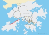
North Lantau Highway
Encyclopedia
Route 8 (Hong Kong)
Route 8 of Hong Kong is an 3-lane carriageway dual 3-lane highway that links Lantau Island, Tsing Yi Island, Cheung Sha Wan in West Kowloon, and Sha Tin in the Northeast New Territories of Hong Kong. It is a combination of many sections....
of Hong Kong
Hong Kong
Hong Kong is one of two Special Administrative Regions of the People's Republic of China , the other being Macau. A city-state situated on China's south coast and enclosed by the Pearl River Delta and South China Sea, it is renowned for its expansive skyline and deep natural harbour...
, linking Hong Kong International Airport
Hong Kong International Airport
Hong Kong International Airport is the main airport in Hong Kong. It is colloquially known as Chek Lap Kok Airport , being built on the island of Chek Lap Kok by land reclamation, and also to distinguish it from its predecessor, the closed Kai Tak Airport.The airport opened for commercial...
and Lantau Island
Lantau Island
Lantau Island , based on the old local name of Lantau Peak , is the largest island in Hong Kong, located at the mouth of the Pearl River. Administratively, most of Lantau Island is part of the Islands District of Hong Kong...
with the rest of the territory. It is an expressway
Controlled-access highway
A controlled-access highway is a highway designed exclusively for high-speed vehicular traffic, with all traffic flow and ingress/egress regulated...
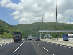
with three lanes in each direction for its entire length with full width hard shoulders for emergencies and breakdowns. The speed limit is 110km/h.
North Lantau Highway is 12.5 kilometres (7.8 mi) in length, starting from Airport Road
Airport Road, Hong Kong
Airport Road is the main road to the airport and a road connection from Tung Chung and Hong Kong International Airport in Chek Lap Kok, Hong Kong....
on Chek Lap Kok
Chek Lap Kok
Chek Lap Kok was an island in the western waters of Hong Kong. Together with the smaller Lam Chau, it was leveled and merged via land reclamation into the platform for the current Hong Kong International Airport, which opened for commercial operations in 1998...
. The road then crosses onto Lantau Island and bypasses the Tung Chung New Town. The road then travels along the northern coast of Lantau Island, next to Airport Express
Airport Express (MTR)
The Airport Express is one of the lines of the Mass Transit Railway serving Hong Kong. It links the principal urban areas of Hong Kong to Hong Kong International Airport and the associated AsiaWorld-Expo exhibition and convention centre....
and Tung Chung Line
Tung Chung Line (MTR)
The Tung Chung Line is one of the 10 lines of the MTR system in Hong Kong. It links Tung Chung with Hong Kong Island. A part of the Tung Chung Line was built along with the Kap Shui Mun Bridge and the Tsing Ma Bridge...
of the MTR
MTR
Mass Transit Railway is the rapid transit railway system in Hong Kong. Originally opened in 1979, the system now includes 211.6 km of rail with 155 stations, including 86 railway stations and 69 light rail stops...
. This section is built on new reclamation
Land reclamation in Hong Kong
Land is in short supply in Hong Kong, and land reclamation has been conducted there since the mid-19th century.-Projects:One of the earliest and famous project was the Praya Reclamation Scheme, which added 50 to of land in 1890 during the second phase of construction...
and through various cuttings
Hillclimbing (railway)
While railways have a great ability to haul very heavy loads, this advantage only really applies when the tracks are fairly level. As soon as the gradients stiffen, the tonnage that can be hauled is greatly diminished.- Techniques to overcome steep hills :...
. Finally, the road climbs over Ta Shui Wan
Ta Shui Wan
Ta Shui Wan was a bay in Yam O, Lantau Island, New Territories, Hong Kong, located between Tai Yam Teng and Ngong Shuen Au . The bay was reclaimed to construct MTR Sunny Bay Station....
and Tsing Chau Wan to meet the Lantau Link
Lantau Link
The Lantau Link, formerly known as the Lantau Fixed Crossing, is a series of infrastructures linking Hong Kong International Airport to the urban areas in Hong Kong. It was officially opened on 27 April 1997, and it opened to traffic on 22 May the same year.-Infrastructure:The Lantau Link is 3.5 km...
and its bridges.
There are 4 junctions along this road:
- Yam OYam OYam O is a bay located on the northeast shore of Lantau Island, in the New Territories of Hong Kong. It is part of the Tsuen Wan Rural West constituency of the Tsuen Wan District Council.Yam O was the one and only natural lumber preservation zone in Hong Kong...
(Exit to Penny's Bay HighwayPenny's Bay HighwayPenny's Bay Highway is a highway in Lantau Island, Hong Kong. The highway was built to serve as a road which links North Lantau Highway to Hong Kong Disneyland Resort in Penny's Bay...
, Yam OYam OYam O is a bay located on the northeast shore of Lantau Island, in the New Territories of Hong Kong. It is part of the Tsuen Wan Rural West constituency of the Tsuen Wan District Council.Yam O was the one and only natural lumber preservation zone in Hong Kong...
and Hong Kong Disneyland ResortHong Kong Disneyland ResortThe Hong Kong Disneyland Resort is a resort built by the Government of Hong Kong and The Walt Disney Company in Hong Kong on reclaimed land beside Penny's Bay, at the northeastern tip of Lantau Island, approximately two kilometres from Discovery Bay...
); - Tai Ho WanTai Ho WanTai Ho Wan is a bay on the north shore of Lantau Island in Hong Kong. It is located west of Siu Ho Wan, and northeast of Tung Chung. The surrounding land was originally part of the North Lantau New Town scope, the current slowdown in its plans because of population growth and environmental groups...
(Exit to MTR Siu Ho Wan Depot); and - Tung Chung East and Tung Chung North (Exits to Tung ChungTung ChungTung Chung, meaning 'eastern stream', is an area situated on the north-western coast of Lantau Island in Hong Kong. Tung Chung, currently one of the latest generation of new towns, was formerly a rural village around Tung Chung Wan, and along the delta and lower courses of Tung Chung River and Ma...
)
North Lantau Highway has the highest speed limit
Speed limit
Road speed limits are used in most countries to regulate the speed of road vehicles. Speed limits may define maximum , minimum or no speed limit and are normally indicated using a traffic sign...
in Hong Kong at 110 km/h (68mph).
Flooding
On June 7, 2008, North Lantau Highway and its service road, Cheung Tung Road, were completely flooded at Caribbean Coast, Tung ChungTung Chung
Tung Chung, meaning 'eastern stream', is an area situated on the north-western coast of Lantau Island in Hong Kong. Tung Chung, currently one of the latest generation of new towns, was formerly a rural village around Tung Chung Wan, and along the delta and lower courses of Tung Chung River and Ma...
at 6am, under rainfall as high as 145mm in an hour. The highway was forced to close completely, rendering the Hong Kong International Airport
Hong Kong International Airport
Hong Kong International Airport is the main airport in Hong Kong. It is colloquially known as Chek Lap Kok Airport , being built on the island of Chek Lap Kok by land reclamation, and also to distinguish it from its predecessor, the closed Kai Tak Airport.The airport opened for commercial...
on Chek Lap Kok
Chek Lap Kok
Chek Lap Kok was an island in the western waters of Hong Kong. Together with the smaller Lam Chau, it was leveled and merged via land reclamation into the platform for the current Hong Kong International Airport, which opened for commercial operations in 1998...
inaccessible by road. With a water depth of three metres, and the flood extending 500 metres in length, some 20 vehicles were trapped on the scene by the floodwater. Another thousand vehicles were trapped in the resulting traffic jam, extending about 10km long back to the toll plaza of Lantau Link
Lantau Link
The Lantau Link, formerly known as the Lantau Fixed Crossing, is a series of infrastructures linking Hong Kong International Airport to the urban areas in Hong Kong. It was officially opened on 27 April 1997, and it opened to traffic on 22 May the same year.-Infrastructure:The Lantau Link is 3.5 km...
. Service was increased on the MTR
MTR
Mass Transit Railway is the rapid transit railway system in Hong Kong. Originally opened in 1979, the system now includes 211.6 km of rail with 155 stations, including 86 railway stations and 69 light rail stops...
Tung Chung Line and Airport Express
Airport Express (MTR)
The Airport Express is one of the lines of the Mass Transit Railway serving Hong Kong. It links the principal urban areas of Hong Kong to Hong Kong International Airport and the associated AsiaWorld-Expo exhibition and convention centre....
to alleviate passenger flow.
The highway was partially reopened starting from 4pm that day.
See also
- Route 8Route 8 (Hong Kong)Route 8 of Hong Kong is an 3-lane carriageway dual 3-lane highway that links Lantau Island, Tsing Yi Island, Cheung Sha Wan in West Kowloon, and Sha Tin in the Northeast New Territories of Hong Kong. It is a combination of many sections....
- Penny's Bay HighwayPenny's Bay HighwayPenny's Bay Highway is a highway in Lantau Island, Hong Kong. The highway was built to serve as a road which links North Lantau Highway to Hong Kong Disneyland Resort in Penny's Bay...
- access road from North Lantau Highway to Hong Kong Disneyland ResortHong Kong Disneyland ResortThe Hong Kong Disneyland Resort is a resort built by the Government of Hong Kong and The Walt Disney Company in Hong Kong on reclaimed land beside Penny's Bay, at the northeastern tip of Lantau Island, approximately two kilometres from Discovery Bay...