
Wet Earth Colliery
Encyclopedia
The Wet Earth Colliery has a unique place in British coal mining history, apart from being one of the earliest pits in the country; it is the place where the engineer James Brindley
made water run uphill. The colliery was located on the Manchester Coalfield
in what is now Clifton Country Park
, in Clifton
, Greater Manchester
.
which follows the River Irwell
north to south along the Pendleton Fault
. Many other mines were situated on this major fault which threw up the underlying Carboniferous
coal measures
by some 1000 metres making them accessible for mining since early times. To the east of the fault is the red Triassic
sandstone, to the west are the coal measures which in places outcrop at surface.
in Kearsley
, a few hundred metres to the north of the Wet Earth Colliery shows evidence of early bell pit
working and small ladder pits. The first real working was by the owner of the Clifton Estate, John Heathcote of Glossop
, Derbyshire
in the 1740s. Heathcote sunk two shafts, which were about 15 metres (49 ft) deep to the Doe mine. This seam was 9 ft 7 ½ " thick and dipped at a gradient of 1 in 3½ to the south-west and outcrops in the river valley. The Wet Earth Colliery was begun in 1751 when he sank a deep shaft to the seam about half a mile to the south-east but ran into technical difficulties and had to call on the help of Matthew Fletcher.
had several mines including some in Harwood
, Breightmet
, Bolton and Atherton
. He had two sons, John and Matthew. John
was responsible for sinking a pit in Atherton whilst Matthew took up mining engineering. John Heathcote was having problems with the pit and called upon Matthew Fletcher to help with the sinking of a new shaft, the Gal Pit. A memorial tablet was placed on a cottage at the site showing that Fletcher was responsible for sinking the shaft. The tablet has been lost but a photograph of it is stored in Swinton
Library.
This new shaft was sunk 80 metres (262 ft) above the seam at a point which later was the central focus of the Wet Earth complex. The shaft was later deepened to 100 metres (328 ft) to connect with the Five Quarters mine which at this point was 3 ft 7" thick. The workings were plagued with water, which entered from the River Irwell via the fault. By 1750 the flooding had become so bad that the pit closed and John Heathcote signed the mine over to Fletcher.
 Fletcher was at a loss as how to remove the water from the pit until it came to the attention of James Brindley
(1716–1772). Brindley, a relative of the former owner John Heathcote, was an engineer whose feats included the Bridgewater Canal
, the Trent and Mersey Canal
and later the Chester Canal
, as well as the Harecastle Tunnel
.
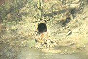
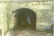
Brindley initially suggested a scheme whereby a Newcomen atmospheric pumping engine
could be used to dewater the mine but this had a downside, as the engine had been plagued with problems in dewatering deep mines. Instead he decided to present a scheme that relied on waterpower. Brindley's scheme had to overcome several obstacles, not least that there was no water on the site to power the engine and that the mine pithead was 7 metres (23 ft) above the level of the River Irwell. Despite these problems, construction started in 1752. The second problem, that of level was solved by building a weir
raising the river level to the Gal Pit level. The outlet of the siphon
was changed during construction and it fed into a small feeder canal
and then to the mine 215 metres (705 ft) away. At the mine, the water fed into a penstock
to control the flow and then on to a 7 metres (23 ft) diameter water wheel
which drove the pumps. The scheme was completed by 1756 and was so successful that it remained in use for the next 170 years, the original water wheel was replaced by a water turbine
in 1867.
By the 1760s Fletcher had expanded his operations and sunk several new pits in the area including the Botany Bay Colliery, the Clifton Hall Colliery
and Ringley, Spindle Point and Robin Hood collieries. He also built a large house for himself just a few metres from the pit, Clifton House, which was demolished many years ago.
By late 1790, a surface canal had been driven to connect the Wet Earth Colliery to the Botany Bay Colliery, this opened fully in 1791. Fletcher decided to link this canal into the nearby Manchester, Bolton and Bury Canal
enabling him to get him coal from mine to the coal wharfs in Manchester
some 10 kilometres (6 mi) away. Although started in 1791, it didn't become linked and navigable until 1800. At the same time, a small canal was cut to connect to a basin cut inside the mine and constructed next to the shaft. This enabled the coal to be loaded directly onto barges and then on to Manchester. This short 1.5 mile section of canal became known as Fletcher's Canal
.
, later to found the Pilkington Tile Company
on a site just metres away from the Gal Pit.
In 1838 the Manchester and Bolton Railway
was opened, and Dixon Fold railway station
was built to the south of Wet Earth Colliery.
was formed. The brothers deepened the shaft that had been sunk by Ellis Fletcher, to reach the Trencherbone mine at a depth of 185 metres (607 ft). During this period, further seams were worked including the Cannel, Victoria, Crumbouke and Five Quarters. In 1910, a tunnel was driven to connect to the Plodder Mine, which appeared to give the mine a further lease of life however the river found a crack in the fault and flooded the mine. After this, the mines were abandoned. The other remaining mines were starting to work out their seams and coupled with the miners' strike in 1921, the mines were finally run down, the last closing in 1928.
There were also a large number of other injuries and incidents one being on May 17, 1874. A Thomas Entwistle discovered a blockage of air, following which an explosion occurred in which he was badly burnt. William and John Ivill (father and son) came to his aid, but during the descent down the shaft were overcome by Blackdamp
and fell 300 feet from the cage to their deaths. A serious fire continued for several days.
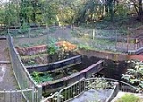
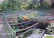
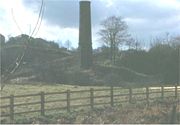 The area of the Wet Earth Colliery was abandoned leaving much of the Gal Pit and surrounding buildings intact. Over the years, most of the material has been removed but there still remains quite a large area where the original workings can be seen. Salford
City Council has designated the area as part of the Clifton Country Park
and made great efforts to restore what is left and has laid out a trail to guide visitors along Fletcher's Canal
, past the river valley workings connected with Brindley's inverted siphon and onto the now capped Gal Pit. Wet Earth Colliery Exploration Group has excavated the old penstock and turbine house and some restoration has been completed.
James Brindley
James Brindley was an English engineer. He was born in Tunstead, Derbyshire, and lived much of his life in Leek, Staffordshire, becoming one of the most notable engineers of the 18th century.-Early life:...
made water run uphill. The colliery was located on the Manchester Coalfield
Manchester Coalfield
The Manchester Coalfield is part of the South East Lancashire Coalfield. Its coal seams were laid down in the Carboniferous period and some easily accessible seams were worked on a small scale from the Middle Ages and extensively from the beginning of the Industrial Revolution in the early 19th...
in what is now Clifton Country Park
Clifton Country Park
Clifton Country Park is a Local Nature Reserve in the Irwell Valley at Clifton, Salford, Greater Manchester, North-west England.The park comprises 48 hectares of wooded area, fields, and lakes. Industrial heritage is also a feature of the park, the remains of the Wet Earth Colliery can be found in...
, in Clifton
Clifton, Greater Manchester
Clifton is a small town within the metropolitan borough of the City of Salford, in Greater Manchester, England. It lies in the Irwell Valley in the northern part of the City of Salford....
, Greater Manchester
Greater Manchester
Greater Manchester is a metropolitan county in North West England, with a population of 2.6 million. It encompasses one of the largest metropolitan areas in the United Kingdom and comprises ten metropolitan boroughs: Bolton, Bury, Oldham, Rochdale, Stockport, Tameside, Trafford, Wigan, and the...
.
Geology
The colliery is situated in the Irwell ValleyIrwell Valley
The Irwell Valley extends from the Forest of Rossendale in North West England, through to the cities of Salford and Manchester. The River Irwell runs through the valley, along with the River Croal.-Geology:...
which follows the River Irwell
River Irwell
The River Irwell is a long river which flows through the Irwell Valley in the counties of Lancashire and Greater Manchester in North West England. The river's source is at Irwell Springs on Deerplay Moor, approximately north of Bacup, in the parish of Cliviger, Lancashire...
north to south along the Pendleton Fault
Pendleton Fault
The Pendleton Fault, sometimes called the Irwell Valley Fault, stretches for about 20 miles from Bolton in Greater Manchester along the Irwell Valley through Pendleton to Poynton in Cheshire, running northwest–southeast. The fault throws the beds of the Middle Coal Measures of the Manchester...
. Many other mines were situated on this major fault which threw up the underlying Carboniferous
Carboniferous
The Carboniferous is a geologic period and system that extends from the end of the Devonian Period, about 359.2 ± 2.5 Mya , to the beginning of the Permian Period, about 299.0 ± 0.8 Mya . The name is derived from the Latin word for coal, carbo. Carboniferous means "coal-bearing"...
coal measures
Coal Measures
The Coal Measures is a lithostratigraphical term for the coal-bearing part of the Upper Carboniferous System. It represents the remains of fluvio-deltaic sediment, and consists mainly of clastic rocks interstratified with the beds of coal...
by some 1000 metres making them accessible for mining since early times. To the east of the fault is the red Triassic
Triassic
The Triassic is a geologic period and system that extends from about 250 to 200 Mya . As the first period of the Mesozoic Era, the Triassic follows the Permian and is followed by the Jurassic. Both the start and end of the Triassic are marked by major extinction events...
sandstone, to the west are the coal measures which in places outcrop at surface.
Early Mining
The area around Nob EndNob End
Nob End is the site of a former waste tip, and now a Site of Special Scientific Interest near Kearsley, Bolton, England.Standing at the confluence of the River Irwell and River Croal it was used around 1850-70 as a tip for alkaline waste from the production of sodium carbonate by the Leblanc...
in Kearsley
Kearsley
Kearsley is a town within the Metropolitan Borough of Bolton, in Greater Manchester, England. Historically within Lancashire, it lies about 7½ miles northwest of Manchester,5.5 miles south-west of Bury, and about 3¾ miles south of Bolton.It is bounded on the west by Walkden, the east by...
, a few hundred metres to the north of the Wet Earth Colliery shows evidence of early bell pit
Bell pit
A bell pit is a primitive method of mining coal, iron ore or other minerals where the coal or ore lies near the surface.. A shaft is sunk to reach the mineral which is excavated by miners transported to the surface by a winch and removed by means of a bucket, much like a well. It gets its name...
working and small ladder pits. The first real working was by the owner of the Clifton Estate, John Heathcote of Glossop
Glossop
Glossop is a market town within the Borough of High Peak in Derbyshire, England. It lies on the Glossop Brook, a tributary of the River Etherow, about east of the city of Manchester, west of the city of Sheffield. Glossop is situated near Derbyshire's county borders with Cheshire, Greater...
, Derbyshire
Derbyshire
Derbyshire is a county in the East Midlands of England. A substantial portion of the Peak District National Park lies within Derbyshire. The northern part of Derbyshire overlaps with the Pennines, a famous chain of hills and mountains. The county contains within its boundary of approx...
in the 1740s. Heathcote sunk two shafts, which were about 15 metres (49 ft) deep to the Doe mine. This seam was 9 ft 7 ½ " thick and dipped at a gradient of 1 in 3½ to the south-west and outcrops in the river valley. The Wet Earth Colliery was begun in 1751 when he sank a deep shaft to the seam about half a mile to the south-east but ran into technical difficulties and had to call on the help of Matthew Fletcher.
Period 1750–1804
Matthew Fletcher (1731 – 24 August 1808)
Jacob Fletcher, a mine owner from BoltonBolton
Bolton is a town in Greater Manchester, in the North West of England. Close to the West Pennine Moors, it is north west of the city of Manchester. Bolton is surrounded by several smaller towns and villages which together form the Metropolitan Borough of Bolton, of which Bolton is the...
had several mines including some in Harwood
Harwood, Greater Manchester
Harwood is a suburb to the north-northeast of Bolton, Greater Manchester, bordering Bury in North West England.-History:The township was recorded as Harewode in 1212 and 1302. The manor which included Bradshaw, was part of the Manchester fee held by the Grelleys in the Middle Ages. In 1212 it was...
, Breightmet
Breightmet
Breightmet is a neighbourhood of Bolton, in Greater Manchester, England. Historically a township of the civil and ecclesiastical parish of Bolton le Moors in the Salford hundred of Lancashire, it lies 2 miles north east of Bolton and 4 miles north-west of Bury...
, Bolton and Atherton
Atherton, Greater Manchester
Atherton is a town within the Metropolitan Borough of Wigan, in Greater Manchester, England, historically a part of Lancashire. It is east of Wigan, north-northeast of Leigh, and northwest of Manchester...
. He had two sons, John and Matthew. John
Fletcher, Burrows and Company
Fletcher, Burrows and Company was a coal mining company that owned collieries in Atherton, Greater Manchester, England. Gibfield, Howe Bridge and Chanters collieries exploited the coal mines of the middle coal measures in the Manchester Coalfield...
was responsible for sinking a pit in Atherton whilst Matthew took up mining engineering. John Heathcote was having problems with the pit and called upon Matthew Fletcher to help with the sinking of a new shaft, the Gal Pit. A memorial tablet was placed on a cottage at the site showing that Fletcher was responsible for sinking the shaft. The tablet has been lost but a photograph of it is stored in Swinton
Swinton, Greater Manchester
Swinton is a town within the City of Salford, in Greater Manchester, England. Located on the A6 road it stands on gently sloping ground on the southwest side of the River Irwell, and within the bounds of the orbital M60 motorway. It is west-northwest of Salford, and west-northwest of Manchester...
Library.
This new shaft was sunk 80 metres (262 ft) above the seam at a point which later was the central focus of the Wet Earth complex. The shaft was later deepened to 100 metres (328 ft) to connect with the Five Quarters mine which at this point was 3 ft 7" thick. The workings were plagued with water, which entered from the River Irwell via the fault. By 1750 the flooding had become so bad that the pit closed and John Heathcote signed the mine over to Fletcher.
(1716–1772). Brindley, a relative of the former owner John Heathcote, was an engineer whose feats included the Bridgewater Canal
Bridgewater Canal
The Bridgewater Canal connects Runcorn, Manchester and Leigh, in North West England. It was commissioned by Francis Egerton, 3rd Duke of Bridgewater, to transport coal from his mines in Worsley to Manchester...
, the Trent and Mersey Canal
Trent and Mersey Canal
The Trent and Mersey Canal is a in the East Midlands, West Midlands, and North West of England. It is a "narrow canal" for the vast majority of its length, but at the extremities—east of Burton upon Trent and west of Middlewich—it is a wide canal....
and later the Chester Canal
Chester Canal
The Chester Canal was a canal linking the south Cheshire town of Nantwich with the River Dee at Chester, providing a route for produce from Nantwich to reach Chester and, beyond it, the sea via the Dee estuary.-History:...
, as well as the Harecastle Tunnel
Harecastle Tunnel
Harecastle Tunnel is a canal tunnel on the Trent and Mersey Canal at Kidsgrove in Staffordshire. It is made up of two separate, parallel, tunnels described as Brindley and the later Telford after the engineers that constructed them. Today only the Telford tunnel is navigable...
.
Brindley initially suggested a scheme whereby a Newcomen atmospheric pumping engine
Newcomen steam engine
The atmospheric engine invented by Thomas Newcomen in 1712, today referred to as a Newcomen steam engine , was the first practical device to harness the power of steam to produce mechanical work. Newcomen engines were used throughout Britain and Europe, principally to pump water out of mines,...
could be used to dewater the mine but this had a downside, as the engine had been plagued with problems in dewatering deep mines. Instead he decided to present a scheme that relied on waterpower. Brindley's scheme had to overcome several obstacles, not least that there was no water on the site to power the engine and that the mine pithead was 7 metres (23 ft) above the level of the River Irwell. Despite these problems, construction started in 1752. The second problem, that of level was solved by building a weir
Weir
A weir is a small overflow dam used to alter the flow characteristics of a river or stream. In most cases weirs take the form of a barrier across the river that causes water to pool behind the structure , but allows water to flow over the top...
raising the river level to the Gal Pit level. The outlet of the siphon
Siphon
The word siphon is sometimes used to refer to a wide variety of devices that involve the flow of liquids through tubes. But in the English language today, the word siphon usually refers to a tube in an inverted U shape which causes a liquid to flow uphill, above the surface of the reservoir,...
was changed during construction and it fed into a small feeder canal
Canal
Canals are man-made channels for water. There are two types of canal:#Waterways: navigable transportation canals used for carrying ships and boats shipping goods and conveying people, further subdivided into two kinds:...
and then to the mine 215 metres (705 ft) away. At the mine, the water fed into a penstock
Penstock
A penstock is a sluice or gate or intake structure that controls water flow, or an enclosed pipe that delivers water to hydraulic turbines and sewerage systems. It is a term that has been inherited from the technology of wooden watermills....
to control the flow and then on to a 7 metres (23 ft) diameter water wheel
Water wheel
A water wheel is a machine for converting the energy of free-flowing or falling water into useful forms of power. A water wheel consists of a large wooden or metal wheel, with a number of blades or buckets arranged on the outside rim forming the driving surface...
which drove the pumps. The scheme was completed by 1756 and was so successful that it remained in use for the next 170 years, the original water wheel was replaced by a water turbine
Water turbine
A water turbine is a rotary engine that takes energy from moving water.Water turbines were developed in the 19th century and were widely used for industrial power prior to electrical grids. Now they are mostly used for electric power generation. They harness a clean and renewable energy...
in 1867.
By the 1760s Fletcher had expanded his operations and sunk several new pits in the area including the Botany Bay Colliery, the Clifton Hall Colliery
Clifton Hall Colliery
Clifton Hall Colliery was one of two coal mines in Clifton on the Manchester Coalfield, historically within Lancashire which was incorporated into the City of Salford in Greater Manchester, England in 1974....
and Ringley, Spindle Point and Robin Hood collieries. He also built a large house for himself just a few metres from the pit, Clifton House, which was demolished many years ago.
By late 1790, a surface canal had been driven to connect the Wet Earth Colliery to the Botany Bay Colliery, this opened fully in 1791. Fletcher decided to link this canal into the nearby Manchester, Bolton and Bury Canal
Manchester, Bolton and Bury Canal
The Manchester Bolton & Bury Canal is a disused canal in Greater Manchester, England, built to link Bolton and Bury with Manchester. The canal, when fully opened, was 15 miles 1 furlong long. It was accessed via a junction with the River Irwell in Salford...
enabling him to get him coal from mine to the coal wharfs in Manchester
Manchester
Manchester is a city and metropolitan borough in Greater Manchester, England. According to the Office for National Statistics, the 2010 mid-year population estimate for Manchester was 498,800. Manchester lies within one of the UK's largest metropolitan areas, the metropolitan county of Greater...
some 10 kilometres (6 mi) away. Although started in 1791, it didn't become linked and navigable until 1800. At the same time, a small canal was cut to connect to a basin cut inside the mine and constructed next to the shaft. This enabled the coal to be loaded directly onto barges and then on to Manchester. This short 1.5 mile section of canal became known as Fletcher's Canal
Fletcher's Canal
Fletcher's Canal was a long canal in Greater Manchester, which connected the Wet Earth Colliery to the Manchester Bolton & Bury Canal at Clifton Aqueduct. The canal is now derelict and no longer used....
.
Period 1804–1880
In January 1804, Ellis Fletcher (1765–1834), Matthew Fletcher's nephew, sank a downcast shaft on the Doe Seam equipped with a steam powered winding engine. The original one shaft – the Gal Pit – had given problems with access, ventilation and getting the coal out of the mine. This second shaft gave the pit a new lease of life and production increased. The old gin winding mechanism on the Gal Pit was abandoned when this shaft was opened. On the death of Ellis in 1834, the pit was taken over by his sons Ellis Jnr and John. In 1835, a year after his father, John died, Ellis Jnr lost interest barely keeping the pit going until his own death in 1854. The pit then passed to Charlotte Anne Fletcher. A succession of family, cousins, uncles and sons of these relatives variously owned or worked the mines for the next few years. By 1880, the seams had been almost worked out and the Fletchers lost all interest and sold the mines to the Pilkington brothers, later to found the Pilkington Tile Company
Pilkington's Lancastrian Pottery & Tiles
Pilkington's Lancastrian Pottery & Tiles was a manufacturer of tiles, vases and bowls, based in Clifton, Greater Manchester, England. The company was established in 1892 at Clifton Junction, alongside Fletcher's Canal...
on a site just metres away from the Gal Pit.
In 1838 the Manchester and Bolton Railway
Manchester and Bolton Railway
The Manchester and Bolton Railway was a railway in the historic county of Lancashire, England, connecting Salford to Bolton. It was built by the proprietors of the Manchester, Bolton and Bury Canal Navigation and Railway Company who had in 1831 converted from a canal company...
was opened, and Dixon Fold railway station
Dixon Fold railway station
Dixon Fold railway station was a railway station built on the Manchester and Bolton Railway, between Clifton Junction railway station and Kearsley railway station, in Clifton near Pendlebury.-History:The station opened in 1841...
was built to the south of Wet Earth Colliery.
Period 1880–1928
The Pilkingtons undertook the final phase of expansion at the pit. The surface equipment was replaced and the coal was now loaded and shipped without washing to save both time and money. The output under the Pilkingtons doubled and the Clifton and Kersley Coal CompanyClifton and Kersley Coal Company
The Clifton and Kersley Coal Company or Clifton and Kearsley Coal Company was a coal mining company that operated in Clifton and Kearsley in the Irwell Valley, then in the historic county of Lancashire, England. Its collieries exploited the coal mines of the middle coal measures in the Manchester...
was formed. The brothers deepened the shaft that had been sunk by Ellis Fletcher, to reach the Trencherbone mine at a depth of 185 metres (607 ft). During this period, further seams were worked including the Cannel, Victoria, Crumbouke and Five Quarters. In 1910, a tunnel was driven to connect to the Plodder Mine, which appeared to give the mine a further lease of life however the river found a crack in the fault and flooded the mine. After this, the mines were abandoned. The other remaining mines were starting to work out their seams and coupled with the miners' strike in 1921, the mines were finally run down, the last closing in 1928.
Accidents
There were at least 38 deaths at the colliery,There were also a large number of other injuries and incidents one being on May 17, 1874. A Thomas Entwistle discovered a blockage of air, following which an explosion occurred in which he was badly burnt. William and John Ivill (father and son) came to his aid, but during the descent down the shaft were overcome by Blackdamp
Blackdamp
Blackdamp is an asphyxiant, reducing the available oxygen content of air to a level incapable of sustaining human or animal life. It is not a single gas but a mixture of unbreathable gasses left after oxygen is removed from the air and typically consists of nitrogen, argon, carbon dioxide and...
and fell 300 feet from the cage to their deaths. A serious fire continued for several days.
The Present Day
City of Salford
The City of Salford is a city and metropolitan borough of Greater Manchester, England. It is named after its largest settlement, Salford, but covers a far larger area which includes the towns of Eccles, Swinton-Pendlebury, Walkden and Irlam which apart from Irlam each have a population of over...
City Council has designated the area as part of the Clifton Country Park
Clifton Country Park
Clifton Country Park is a Local Nature Reserve in the Irwell Valley at Clifton, Salford, Greater Manchester, North-west England.The park comprises 48 hectares of wooded area, fields, and lakes. Industrial heritage is also a feature of the park, the remains of the Wet Earth Colliery can be found in...
and made great efforts to restore what is left and has laid out a trail to guide visitors along Fletcher's Canal
, past the river valley workings connected with Brindley's inverted siphon and onto the now capped Gal Pit. Wet Earth Colliery Exploration Group has excavated the old penstock and turbine house and some restoration has been completed.