
Atherton, Greater Manchester
Encyclopedia
Atherton is a town within the Metropolitan Borough of Wigan
, in Greater Manchester
, England, historically
a part of Lancashire
. It is 6 miles (9.7 km) east of Wigan
, 2 miles (3.2 km) north-northeast of Leigh
, and 9 miles (14.5 km) northwest of Manchester
. For about 300 years from the 17th century Atherton was referred to as Chowbent, which was frequently shortened to Bent, the town's old nickname.
Along with neighbouring Shakerley
, Atherton has been associated with coal mining and nail manufacture since the 14th century, encouraged by its outcrops of coal. At the beginning of the 20th century the town was described as "the centre of a district of collieries, cotton mills, and iron-works, which cover the surface of the country with their inartistic buildings and surroundings, and are linked together by the equally unlovely dwellings of the people". Atherton's last deep coal mine closed in 1966, and the last working cotton mills closed in 1999. Today the town is the third largest retail centre in the Borough of Wigan; almost 20% of those employed in the area work in the wholesale and retail trade, although there is still some significant manufacturing industry in the town.
Evidence has been discovered of a Roman road passing through the area, on the ancient route between Coccium (Wigan) and Mamucium (Manchester). Following the Anglo-Saxon invasion of England, Atherton, which is built on and around seven brooks, became part of the manor of Warrington until the Norman conquest, when it became a township or vill in the ancient parish of Leigh. Since 1974 the town has been part of the Metropolitan Borough of Wigan, a local government district of the Metropolitan County
of Greater Manchester
.
Opinions differ as to the derivation of the name. One is the farmstead or village of a man named Aethelhere, an Old English personal name and the suffix tun, meaning an enclosure, farmstead or manor estate; another is adre, Saxon for little brook with the suffix tun. Either is possible as Atherton is bounded by brooks to the west and south, and crossed by several others. The western boundary is Hindsford Brook, originally named Goderic Brook after a Saxon saint.
The Chow – also recorded as Chew, Cholle, and Chowl – family were tenants of the Athertons living at the valley by Chanters Brook. This part of the township became known as Chow's Bent but the meaning of Bent has been lost, perhaps a bend or slope. It was referred to in the 14th century as Chollebynt or Shollebent. Chowbent, or Bent, was the name given to the built-up part of Atherton from the mid-17th century for at least 300 years. As the population grew, the resulting town was called Atherton, although the names Chowbent or Bent are used by locals.
settlement have been found in the area. The Roman road between Manchester and Wigan is shown on the 1849 6" OS map
crossing Miller's Lane at 90 degrees about half way down. The site of Gadbury Brickworks at the Gibfield Colliery
site has been excavated, and evidence of Roman and possibly earlier settlements found.
was held by the Atherton family from the de Botelers, whose chief manor was at Warrington
. William and Nicholas Atherton fought at the Battle of Agincourt
in 1415. The manor house was situated towards the south of the ancient township. Christopher Saxton
's map shows that there was a medieval deer park
in the time of Elizabeth I. "Mad" Richard Atherton, the last direct male descendant of the Athertons is remembered for two events; his expulsion of the congregation from the first Chowbent Chapel in 1721, and his rebuilding of Atherton Hall
on a grand scale, to designs by architect William Wakefield. Work on the hall started in 1723 and was not finished until 1743. The carriage drive from the hall led over Lion's Bridge down an avenue to gates which faced the parish church in Leigh
where the Atherton's had a chapel.
Richard Vernon Atherton was the last of the Atherton male line. He married Elizabeth Farington and had a daughter Elizabeth.
The Atherton family's association with the township ended with Richard Atherton's death in 1726.
His daughter, Elizabeth, married Robert Gwillym and their son, Robert Vernon Atherton, married Henrietta Maria Legh. They had five children, the sons died young, their eldest daughter Henrietta Maria Atherton married Thomas Powys, 2nd Baron Lilford whose father was ennobled by Pitt the Younger in 1797, taking the title of Baron Lilford
. He left his estates to his son, Thomas Atherton Powys
. The Atherton estate was inherited by Lord Lilford, who preferred to live at his family seat, Lilford Hall
in Northamptonshire
. Lord Lilford could not afford the upkeep of another house so Atherton Hall was put up for sale but after failing to sell, it was demolished in 1824. Some of the outbuildings were left standing and are private property still known as Atherton Hall. This portion of Atherton was incorporated into Leigh
in 1894 and the area became a public park.
, in 1642 men of Chowbent were on their way to Leigh Church when word came that James Stanley, 7th Earl of Derby
's Royalist
troops were marching through Leigh probably on route for Manchester. The men of Chowbent armed themselves and drove the Earl's men back to Lowton Common, killing some, wounding others and taking prisoner about 200 men: "... we are all upon our guard, and the Naylors of Chowbent, instead of making Nayles, have busied themselves making Bills and Battle Axes." (Civil War tracts of Lancashire, Chetham Society Series, vol II).
In 1715, during the Jacobite Uprising the supporters of the Old Pretender were marching on Preston. General Charles Wills sent a letter to Minister Wood of Chowbent Chapel asking him to raise a force to be at Cuerden Green the following day, 12 November. Minister Wood led a force of Chowbent men who were given the job of guarding the bridge over the River Ribble
at Walton-le-Dale
and a ford at Penwortham
, which they defended successfully. The Highlanders were routed, and for his efforts Parson James Wood was given £100 annuity by Parliament and the title "The General" by his congregation.
, was associated with coal mining and nail manufacture. Alexander Naylor was taxed on his goods in 1332, showing the industry was present for at least 600 years, encouraged by the proximity of outcrops of coal. Iron
was brought from Derbyshire, Yorkshire and even Spain. A variety of nails were made, lath
nails, slate
nails, thatching nails and sparrowbills. The nail smithies also manufactured plough
s and scythe
s; their products were taken by pack horse to be sold in Manchester, Denbigh, Clitheroe, and Kendal. The nail industry developed into the manufacture of nuts and bolts. Thomas Blakemore was the first in 1843 and by 1853 there were eight makers of nuts and bolts including James Prestwich and Robert Parker. Some manufacturers of nuts and bolts made spindles and flyers for spinning machinery. Collier Brook Bolt Works on Bag Lane dating from 1856 survives and is a Grade II listed building.
Coal
had been mined for several hundred years in numerous shallow shafts and adit
s, but took on greater importance when in 1776 Robert Vernon Atherton leased the coal rights to Thomas Guest from Leigh and John Fletcher from Bolton. In 1845 the era of deep mining arrived with the sinking of Fletcher's Lover's Lane pit at Howe Bridge
. The Crombouke Day-Eye, a drift mine accessing the shallow Brassy and Crombouke mines, opened in 1870 and closed in 1907. (A coal seam was referred to as a "mine" in this part of Lancashire.) By the early 1870s Fletcher, Burrows and Company
's Howe Bridge Colliery
, the biggest of the three Howe Bridge pits, was sunk to the Black & White, or Seven Foot mine. This pit closed in 1959. Gibfield Colliery, situated alongside the Bolton and Leigh Railway
, was working in 1829, coal was mined from the Trencherbone mine. Forty years later a 1169 feet (356.3 m) shaft was sunk to Arley mine. The pit closed in 1963. In September 1913 the first pit head baths in the country were opened at Gibfield. Chanters Colliery
was in Hindsford
, where 1120 feet (341.4 m) shafts were sunk to the Trencherbone Mine in 1854. In the late 1890s shafts were deepened to 1800 feet (548.6 m) to reach the Arley Mine. Atherton had its share of mining disasters, on 11 February 1850 five men died in a gas explosion caused by a lighted candle at Gibfield and on 28 March 1872 twenty-seven men died at Lovers Lane Colliery after a firedamp
explosion caused by blown-out shot.
More recently on 6 March 1957 eight men died at Chanters Colliery after an explosion of gas.
Chanters closed in 1966 bringing the era of deep coal mining in the town to an end.
In 1908, the Lancashire and Cheshire Coal Owners Association opened Howe Bridge Mines Rescue Station
.
The cotton mill
s grew out of a cottage spinning and weaving industry that was widespread across the district. As industrialisation gathered pace, local weavers felt threatened by the advent of powered loom
s, and in April 1812 a mob smashed the machines and burnt down a new factory, Westhoughton Mill
, in neighbouring Westhoughton. For this, the Luddite
s, three men and a boy of 14, were tried at Lancaster Assizes
and hanged. Fustian
was woven and after 1827 silk
also was brought from Manchester. In 1938 James Burton owned cotton mills on both sides of the Hindsford Brook including Lodge Mill. Dan Lane Spinning and Doubling Mills were built in the 1840s and lasted until the 1950s. Howe Bridge Spinning Mills, the largest complex in Atherton was started in 1868 and the last mill built in 1919. It closed as a textile factory in early 1999. Mills built in the 20th century were Laburnum Mills in 1905 (closed 1980), and Ena Mill in 1908 which closed in 1999. The Ena Mill is a Grade II listed building converted for other uses.
. The ward elects three councillors to the 75-member metropolitan borough council, Wigan's local authority. As of 2009, two ward councillors of Atherton are Independents and one is a member of the Labour Party
.
Historically, Atherton formed part of the hHundred of West Derby
, a judicial division of southwest Lancashire. Atherton was one of the six townships or vills that made up the ancient parish of Leigh. The townships existed before the parish. The manor
of Atherton was held by the Atherton family from the de Botelers, whose chief manor was at Warrington
.
Under the terms of the Poor Law Amendment Act 1834
the townships formed part of the Leigh Poor Law Union
which was established on 26 January 1837 comprising an area covering the whole of the ancient parish of Leigh and part of Winwick. There were workhouses in existence in Pennington, Culcheth, Tyldesley, Lowton and Hag Fold in Atherton but Leigh Union workhouse
at Atherleigh replaced these in the 1850s. In 1863 the Local Government Act 1858 was adopted for the township, meaning it was governed by a local board of health, a type of regulatory body responsible for standards of hygiene and sanitation in the township. In 1894 part of the township was added to Leigh Urban District; the remainder became Atherton Urban District
. The urban district
was abolished in 1974 under the Local Government Act 1972
, when the area became part of the Metropolitan Borough of Wigan, a local government district of the metropolitan county
of Greater Manchester
.
Following a review of parliamentary representation in Greater Manchester, Atherton is part of the Bolton West Parliamentary constituency. It is the only ward in the Wigan borough to be represented outside of a Wigan borough seat (the remainder of the borough is represented by Leigh, Makerfield or Wigan). Atherton's MP is Julie Hilling
who won the parliamentary seat for Bolton West at the 2010 General Election.
, Atherton is situated 6 miles (9.7 km) east of Wigan and 9 miles (14.5 km) west-northwest of the city of Manchester, at the eastern end of the Metropolitan Borough of Wigan.
Atherton, which includes Hindsford
to the southeast, Howe Bridge
in the southwest, and Hag Fold in the north, is generally low lying. The soil is clay in much of the township. The southwest of the town is 100 feet (30.5 m) above sea level, rising to 250 feet (76.2 m) in the north. Atherton is built around seven brooks: the Shakerley Brook forms the western boundary with Tyldesley; Chanters Brook flows through the area known as "The Valley"; Knight's Brook (Bag Lane); Colliers Brook; Small Brook is the boundary with Westleigh
; Westhoughton Brook forms the boundary with Daisy Hill; and Red Waters Brook. The underlying rocks are the coal measures
of the Manchester Coalfield
.
Atherton's climate is generally temperate, like the rest of Greater Manchester. The mean highest and lowest temperatures (13.2 °C (55.8 °F) and 6.4 °C (43.5 °F)) are slightly above the national average, while the annual rainfall (806.6 millimetres (31.8 in)) and average hours of sunshine (1394.5 hours) are respectively above and below the national averages.
The town is situated on the old high road, now the A579 from Bolton to Leigh. The A577
runs from the town to Tyldesley in one direction and to Wigan in the other.
At the time of the United Kingdom Census 2001
, according to the Office for National Statistics
, the Urban Subdivision of Atherton was part of the Greater Manchester Urban Area
and had a total resident population of 20,302, of which 9,908 (48.8%) were male and 10,394 (51.2%) were female, living in 8,745 households. The settlement occupied 429 hectares (1.7 sq mi), compared with 431 hectares (1.7 sq mi) in the 1991 census. Its population density was 47.32 people per hectare compared with an average of 40.20 across the Greater Manchester Urban Area. The median age of the population was 40, compared with 36 within the Greater Manchester Urban Area and 37 across England and Wales.
The majority of the population of Atherton were born in England (96.29%); 1.56% were born elsewhere within the United Kingdom, 0.89% within the rest of the European Union, and 1.26% elsewhere in the world.
Data on religious beliefs across the town in the 2001 census show that 86.6% declared themselves to be Christian
, 7.2% said they held no religion, and 0.3% reported themselves as Hindu
.
Travel to Work Area
, whilst the southern part is within the Manchester
TTWA. The entire town is within the Manchester Larger Urban Zone.
At the time of the 2001 Census, there were 8,755 people (43.1%) in employment who were resident within Atherton. Of these, 19.65% worked in the wholesale and retail trade, including repair of motor vehicles; 19.28% worked within manufacturing industry; and 10.27% worked within the health and social work sector. The Census recorded the economic activity of residents aged 16–74 as 36.7% in full-time employment, 11.0% in part-time employment, 6.8% self-employed, 4.0% unemployed, 1.7% students with jobs, 3.2% students without jobs, 14.6% retired, 6.5% looking after home or family, 11.8% permanently sick or disabled, and 3.8% economically inactive for other reasons. The 4.0% unemployment rate in Atherton was high compared with the national rate of 3.3%. According to the Office for National Statistics estimates, during the period between April 2001 and March 2002, the average gross income of households in Atherton was £380 per week (£19,760 per year), substantially less than the £470 per week (£24,440) for the rest of the North West. The average car ownership per household was 1.01, compared with 0.93 across the Greater Manchester Urban Area; 43.74% of households owned a single car or van, and 30.76% owned none.
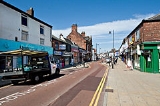
Atherton, the third largest retail centre in the Wigan Borough, has a small pedestrian shopping centre. Most shops front onto Market Street and date from late Victorian times, the majority operated by small independent retailers, although there is a supermarket
that brings customers into the town centre. Older, low cost, mostly terraced housing, surrounds the centre of town. Bolts and fastenings are still manufactured in Atherton by Smith Bullough, one of a few remaining bolt and nut manufacturers in the UK.
As of 2009, a business park is planned for the former Gibfield Colliery site.
, St John's Church (1879), and
Chanters Farmhouse, all of which are listed buildings. It is thought that the name "Chanters" derives from a chantry
granted by the Bishop of Lichfield in 1360 to Sir William de Atherton. The name is also given to a bridge over the Hindsford Brook and a former colliery. The Obelisk
, similar to one in Leigh, possibly built for Robert Vernon Atherton in 1781, is another Grade II listed structure by the church and former market place.
Between 1873 and 1875, mineowners Fletcher Burrows built a small model village
at Howe Bridge, comprising cottages, shops, a village club, and a bath house for their employees. This Victorian village on either side of Leigh Road, together with St Michael and All Angel's Church, is a conservation area
. The Ena Mill, one of Atherton's large spinning mills, complete with chimney, survives as a reminder of the textile industry.
Atherton Cenotaph at the intersection of Leigh Road and Hamilton Street was designed by local architect Arthur John Hope
and constructed of Darley Dale
stone. The memorial was unveiled on Saturday 21 January 1922 by Private J. Roylance, a soldier blinded in action during the First World War.
in about 1770 and a toll gate was installed on the Atherton boundary on Bolton Road. Shakerley Lane toll road emerged near Green Hall on Bolton Road, and was built to get coal from the Shakerley
pits to the turnpike road.
In 1825 The Bolton and Leigh Railway
received Royal Assent and the single track railway was opened in 1828 bringing the railway to the western side of the township where it was close to the coal mines at Howe Bridge and Gibfield. There was a station at Atherton Bag Lane
and one further south at Atherleigh
This line was connected to the Liverpool and Manchester Railway
by the Kenyon and Leigh Junction Railway in 1831. It was connected to the Tyldesley–Wigan line in 1883, and a station on that line was opened at Chowbent renamed Howe Bridge
in 1901. The Lancashire and Yorkshire Railway
's line from Manchester to Southport passes to the north of Atherton and Atherton Station
which was opened in 1887–88 remains open.
 In 1900, a Bill authorising the South Lancashire Tramways
Company to construct over 62 miles (99.8 km) of tramway in southern Lancashire was given Royal Assent.
However, by November 1900 the South Lancashire Electric Traction and Power Company had acquired the shares. The first section of tramway opened on 20 October 1902 between Lowton
and Four Lanes Ends via Leigh and Atherton. The company got into financial difficulty and in turn became Lancashire United Tramways later Lancashire United Transport
(LUT). LUT had headquarters and a large depot in Howe Bridge. On 16 December 1933, the last tram ran from Leigh to Four Lane Ends. The following day trolley buses took over.
Public transport
in Atherton is co-ordinated by the Greater Manchester Passenger Transport Executive
.
There are public transport links by rail from Atherton and Hag Fold
stations to Wigan
and Manchester operated by Northern Rail
, and by bus to Bolton
, Leigh
, Wigan
, Manchester
, the Trafford Centre
and Middlebrook Retail and Leisure Complex
operated by South Lancs Travel
of Atherton and First Manchester
.
opened in 1840 and Chowbent Unitarian School and Hindsford St Anne's in 1860. Howe Bridge School opened in 1869 and St Philip's a year later. An undenominational School in Lee Street opened in 1871 followed by St George's and Sacred Heart School in Hindsford in 1873. In the 1890s, the Technical School originally opened as a school for Science and Art, followed by St Richard's in 1891, and Flapper Fold Higher Grade School in 1893. Green Hall Special School opened in 1957, and a new infant school was opened on Lodge Lane for Sacred Heart. Hesketh Fletcher Senior School opened in 1967 and closed on 31 August 2011.
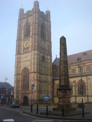 There have been three chapels or churches on the site of the Parish Church of St John the Baptist
. A chapel dedicated to St John the Baptist at Chowbent was built in 1645 by John Atherton. It is sometimes referred to as the Old Bent Chapel. It remained unconsecrated and was used by the Presbyterians. In 1721 Richard Atherton expelled the dissenters and the chapel was consecrated in 1723 by the Bishop of Sodor and Man
. A new chapel on the site was consecrated by the bishop of Chester in 1814. The present church was consecrated in 1879. The church, designed by Austin
and Paley
, is built in Runcorn
stone, the interior is Stourton stone with a Yorkshire stone floor. It is 60 feet (18.3 m) wide, 127 feet (38.7 m) long, and the 24 feet (7.3 m) square tower rises to 120 feet (36.6 m). The fabric of the church has suffered from mining subsidence
.
The New Bent or Chowbent Chapel
, the earliest Nonconformist chapel in Atherton, was built in 1721 and opened in 1722. The chapel was built by the Presbyterian congregation after they were expelled from the first chapel.
St Anne's at Hindsford was originally a mission church occupying a barn which was replaced in 1901 by a church designed by Austin and Paley on Tyldesley Road. It has since been converted to residential use. St Michael and All Angels
at Howe Bridge was built in 1877. There are chapels of the Wesleyan
, Baptist
, Independent Methodist, and Primitive Methodist denominations; a Congregational church at Howe Bridge was opened in 1904. Roman Catholics celebrated mass in a loft behind the Star and Garter public house on Tyldesley Square until the Sacred Heart Catholic Church opened in Hindsford in 1869. The site was given by Lord Lilford with building materials donated by John Holland, manager of Yew Tree Colliery in Tyldesley. It served the growing Catholic population in Hindsford and Tyldesley.
facility in 2008.
Atherton has three amateur football teams, the oldest of which is Atherton Collieries A.F.C., formed in 1916, who play in the North West Counties League.
Others are Atherton Laburnum Rovers F.C.
, also members of the North West Counties Football League
and Atherton Town FC.
force from Atherton Police Station,
which covers Atherton, Tyldesley, Astley and Mosley Common.
The statutory emergency fire and rescue service is provided by the Greater Manchester Fire and Rescue Service
,
from Atherton fire station.
Hospital services are provided by the Wrightington, Wigan and Leigh NHS Foundation Trust who provide an Accident and Emergency
service at Wigan Hospital and outpatient clinics at Leigh Infirmary.
Community health services, including GPs, district and community nurses, dentists and pharmacists, are co-ordinated by
the Ashton, Leigh and Wigan Primary Care Trust.
Waste management is co-ordinated by the Wigan Authority, which is a statutory waste disposal authority in its own right.
Atherton's Distribution Network Operator for electricity is Electricity North West Ltd.
United Utilities manages Atherton's drinking and waste water.
for its members. A public library was opened in 1905 with an Andrew Carnegie
grant. Bent Chapel already had a library in the Chowbent School, and donated 4,000 books to the new town library. Central Park, a 10 acres (4 ha) public park, was created in 1912. Other parks were later provided in Lodge Lane, Hindsford and Devonshire Place. The Urban District Council also acquired the Howe Bridge Welfare grounds in 1963. In the early and mid-20th century Atherton had three cinemas, the Gem in Bullough St, the Savoy, and the Palace on Market Street. An amateur photographic society was formed in 1938. Formby Hall plays host to the Bent 'n' Bongs Beer Festival
over the last weekend of every January.
There were several ministers of note of Chowbent Chapel
including James Wood
, the "General", 1672–1759, who distinguished himself at the Battle of Preston
in 1715. Thomas Walker Horsfield
(1792–1837) was a historian and topographer. Joseph Nightingale
(1775–1824), born in Chowbent, was a prolific English writer and preacher
who subsequently became a Unitarian.
Eric Roberts Laithwaite (1921–1997) was an engineer, principally known for his development of the linear induction motor
and Maglev rail system. Chess grandmaster, Nigel Short
grew up in Atherton and attended St Philip's School. Architect Arthur John Hope
(1875–1960), a partner in Bradshaw Gass & Hope
was born and lived in Atherton. Edward Ormerod
, mining engineer at Gib Field Colliery, invented the Ormerod detaching hook, an important mining safety device.
Metropolitan Borough of Wigan
The Metropolitan Borough of Wigan is a metropolitan borough of Greater Manchester, in North West England. It is named after its largest component town, Wigan and also includes the towns of Leigh, Ashton-in-Makerfield, Ince-in-Makerfield, and Hindley. The borough was formed in 1974 and is an...
, in Greater Manchester
Greater Manchester
Greater Manchester is a metropolitan county in North West England, with a population of 2.6 million. It encompasses one of the largest metropolitan areas in the United Kingdom and comprises ten metropolitan boroughs: Bolton, Bury, Oldham, Rochdale, Stockport, Tameside, Trafford, Wigan, and the...
, England, historically
Historic counties of England
The historic counties of England are subdivisions of England established for administration by the Normans and in most cases based on earlier Anglo-Saxon kingdoms and shires...
a part of Lancashire
Lancashire
Lancashire is a non-metropolitan county of historic origin in the North West of England. It takes its name from the city of Lancaster, and is sometimes known as the County of Lancaster. Although Lancaster is still considered to be the county town, Lancashire County Council is based in Preston...
. It is 6 miles (9.7 km) east of Wigan
Wigan
Wigan is a town in Greater Manchester, England. It stands on the River Douglas, south-west of Bolton, north of Warrington and west-northwest of Manchester. Wigan is the largest settlement in the Metropolitan Borough of Wigan and is its administrative centre. The town of Wigan had a total...
, 2 miles (3.2 km) north-northeast of Leigh
Leigh, Greater Manchester
Leigh is a town within the Metropolitan Borough of Wigan, in Greater Manchester, England. It is southeast of Wigan, and west of Manchester. Leigh is situated on low lying land to the north west of Chat Moss....
, and 9 miles (14.5 km) northwest of Manchester
Manchester
Manchester is a city and metropolitan borough in Greater Manchester, England. According to the Office for National Statistics, the 2010 mid-year population estimate for Manchester was 498,800. Manchester lies within one of the UK's largest metropolitan areas, the metropolitan county of Greater...
. For about 300 years from the 17th century Atherton was referred to as Chowbent, which was frequently shortened to Bent, the town's old nickname.
Along with neighbouring Shakerley
Shakerley
Shakerley is a suburb of Tyldesley in the Metropolitan Borough of Wigan, Greater Manchester, England.It was anciently a hamlet in the northwest of the township of Tyldesley cum Shakerley, in the ancient parish ofLeigh....
, Atherton has been associated with coal mining and nail manufacture since the 14th century, encouraged by its outcrops of coal. At the beginning of the 20th century the town was described as "the centre of a district of collieries, cotton mills, and iron-works, which cover the surface of the country with their inartistic buildings and surroundings, and are linked together by the equally unlovely dwellings of the people". Atherton's last deep coal mine closed in 1966, and the last working cotton mills closed in 1999. Today the town is the third largest retail centre in the Borough of Wigan; almost 20% of those employed in the area work in the wholesale and retail trade, although there is still some significant manufacturing industry in the town.
Evidence has been discovered of a Roman road passing through the area, on the ancient route between Coccium (Wigan) and Mamucium (Manchester). Following the Anglo-Saxon invasion of England, Atherton, which is built on and around seven brooks, became part of the manor of Warrington until the Norman conquest, when it became a township or vill in the ancient parish of Leigh. Since 1974 the town has been part of the Metropolitan Borough of Wigan, a local government district of the Metropolitan County
Metropolitan county
The metropolitan counties are a type of county-level administrative division of England. There are six metropolitan counties, which each cover large urban areas, typically with populations of 1.2 to 2.8 million...
of Greater Manchester
Greater Manchester
Greater Manchester is a metropolitan county in North West England, with a population of 2.6 million. It encompasses one of the largest metropolitan areas in the United Kingdom and comprises ten metropolitan boroughs: Bolton, Bury, Oldham, Rochdale, Stockport, Tameside, Trafford, Wigan, and the...
.
Toponymy
Atherton was recorded as Aderton in 1212 and 1242, and Atherton in 1259.Opinions differ as to the derivation of the name. One is the farmstead or village of a man named Aethelhere, an Old English personal name and the suffix tun, meaning an enclosure, farmstead or manor estate; another is adre, Saxon for little brook with the suffix tun. Either is possible as Atherton is bounded by brooks to the west and south, and crossed by several others. The western boundary is Hindsford Brook, originally named Goderic Brook after a Saxon saint.
The Chow – also recorded as Chew, Cholle, and Chowl – family were tenants of the Athertons living at the valley by Chanters Brook. This part of the township became known as Chow's Bent but the meaning of Bent has been lost, perhaps a bend or slope. It was referred to in the 14th century as Chollebynt or Shollebent. Chowbent, or Bent, was the name given to the built-up part of Atherton from the mid-17th century for at least 300 years. As the population grew, the resulting town was called Atherton, although the names Chowbent or Bent are used by locals.
Early history
Evidence of a Roman road and Bronze AgeBronze Age
The Bronze Age is a period characterized by the use of copper and its alloy bronze as the chief hard materials in the manufacture of some implements and weapons. Chronologically, it stands between the Stone Age and Iron Age...
settlement have been found in the area. The Roman road between Manchester and Wigan is shown on the 1849 6" OS map
Ordnance Survey
Ordnance Survey , an executive agency and non-ministerial government department of the Government of the United Kingdom, is the national mapping agency for Great Britain, producing maps of Great Britain , and one of the world's largest producers of maps.The name reflects its creation together with...
crossing Miller's Lane at 90 degrees about half way down. The site of Gadbury Brickworks at the Gibfield Colliery
Gibfield Colliery
Gibfield Colliery was a coal mine which was part of the Fletcher, Burrows and Company's collieries in Atherton, Greater Manchester, then in the historic county of Lancashire, England.A shaft was sunk to the Trencherbone mine in 1829 by John Fletcher...
site has been excavated, and evidence of Roman and possibly earlier settlements found.
Manor
The manorManorialism
Manorialism, an essential element of feudal society, was the organizing principle of rural economy that originated in the villa system of the Late Roman Empire, was widely practiced in medieval western and parts of central Europe, and was slowly replaced by the advent of a money-based market...
was held by the Atherton family from the de Botelers, whose chief manor was at Warrington
Warrington
Warrington is a town, borough and unitary authority area of Cheshire, England. It stands on the banks of the River Mersey, which is tidal to the west of the weir at Howley. It lies 16 miles east of Liverpool, 19 miles west of Manchester and 8 miles south of St Helens...
. William and Nicholas Atherton fought at the Battle of Agincourt
Battle of Agincourt
The Battle of Agincourt was a major English victory against a numerically superior French army in the Hundred Years' War. The battle occurred on Friday, 25 October 1415 , near modern-day Azincourt, in northern France...
in 1415. The manor house was situated towards the south of the ancient township. Christopher Saxton
Christopher Saxton
Christopher Saxton was an English cartographer, probably born in the parish of Dewsbury, in the West Riding of Yorkshire, England around 1540....
's map shows that there was a medieval deer park
Medieval deer park
A medieval deer park was an enclosed area containing deer. It was bounded by a ditch and bank with a wooden park pale on top of the bank. The ditch was typically on the inside, thus allowing deer to enter the park but preventing them from leaving.-History:...
in the time of Elizabeth I. "Mad" Richard Atherton, the last direct male descendant of the Athertons is remembered for two events; his expulsion of the congregation from the first Chowbent Chapel in 1721, and his rebuilding of Atherton Hall
Atherton Hall, Leigh
Atherton Hall was a mansion house and estate in Atherton historically a part of Lancashire, England but since 1894 incorporated into Leigh, Greater Manchester...
on a grand scale, to designs by architect William Wakefield. Work on the hall started in 1723 and was not finished until 1743. The carriage drive from the hall led over Lion's Bridge down an avenue to gates which faced the parish church in Leigh
Church of St Mary the Virgin, Leigh
The Parish Church of St Mary the Virgin, Leigh is a Church of England parish church in Leigh, Greater Manchester, England. It is a member of the Leigh deanery in the archdeaconry of Salford, diocese of Manchester.It is a Grade II* listed building....
where the Atherton's had a chapel.
Richard Vernon Atherton was the last of the Atherton male line. He married Elizabeth Farington and had a daughter Elizabeth.
The Atherton family's association with the township ended with Richard Atherton's death in 1726.
His daughter, Elizabeth, married Robert Gwillym and their son, Robert Vernon Atherton, married Henrietta Maria Legh. They had five children, the sons died young, their eldest daughter Henrietta Maria Atherton married Thomas Powys, 2nd Baron Lilford whose father was ennobled by Pitt the Younger in 1797, taking the title of Baron Lilford
Baron Lilford
Baron Lilford, of Lilford in the County of Northampton, is a title in the Peerage of Great Britain. It was created in 1797 for Thomas Powys, who had previously represented Northamptonshire in the House of Commons. His grandson, the third Baron, served as a Lord-in-Waiting from 1837 to 1841 in the...
. He left his estates to his son, Thomas Atherton Powys
Thomas Powys, 3rd Baron Lilford
Thomas Atherton Powys, 3rd Baron Lilford , was a British peer and Whig politician.Lilford was the son of Thomas Powys, 2nd Baron Lilford, and Henrietta Maria Atherton of Atherton Hall. He succeeded his father as second Baron in 1825...
. The Atherton estate was inherited by Lord Lilford, who preferred to live at his family seat, Lilford Hall
Lilford Hall
Lilford Hall is a Grade 1 listed stately 100-room home having a Jacobean exterior and Georgian interior with a floor area, located in the eastern part of the County of Northamptonshire in the United Kingdom, south of Oundle and north of Thrapston. A Grade 1 listed building is considered by the UK...
in Northamptonshire
Northamptonshire
Northamptonshire is a landlocked county in the English East Midlands, with a population of 629,676 as at the 2001 census. It has boundaries with the ceremonial counties of Warwickshire to the west, Leicestershire and Rutland to the north, Cambridgeshire to the east, Bedfordshire to the south-east,...
. Lord Lilford could not afford the upkeep of another house so Atherton Hall was put up for sale but after failing to sell, it was demolished in 1824. Some of the outbuildings were left standing and are private property still known as Atherton Hall. This portion of Atherton was incorporated into Leigh
Leigh, Greater Manchester
Leigh is a town within the Metropolitan Borough of Wigan, in Greater Manchester, England. It is southeast of Wigan, and west of Manchester. Leigh is situated on low lying land to the north west of Chat Moss....
in 1894 and the area became a public park.
Two battles
The area was divided in its allegiance during the English Civil WarEnglish Civil War
The English Civil War was a series of armed conflicts and political machinations between Parliamentarians and Royalists...
, in 1642 men of Chowbent were on their way to Leigh Church when word came that James Stanley, 7th Earl of Derby
James Stanley, 7th Earl of Derby
James Stanley, 7th Earl of Derby KG was a supporter of the Royalist cause in the English Civil War.Born at Knowsley, he is sometimes styled the Great Earl of Derby, eldest son of William Stanley, 6th Earl of Derby and Lady Elizabeth de Vere. During his father's life he was known as Lord Strange...
's Royalist
Cavalier
Cavalier was the name used by Parliamentarians for a Royalist supporter of King Charles I and son Charles II during the English Civil War, the Interregnum, and the Restoration...
troops were marching through Leigh probably on route for Manchester. The men of Chowbent armed themselves and drove the Earl's men back to Lowton Common, killing some, wounding others and taking prisoner about 200 men: "... we are all upon our guard, and the Naylors of Chowbent, instead of making Nayles, have busied themselves making Bills and Battle Axes." (Civil War tracts of Lancashire, Chetham Society Series, vol II).
In 1715, during the Jacobite Uprising the supporters of the Old Pretender were marching on Preston. General Charles Wills sent a letter to Minister Wood of Chowbent Chapel asking him to raise a force to be at Cuerden Green the following day, 12 November. Minister Wood led a force of Chowbent men who were given the job of guarding the bridge over the River Ribble
River Ribble
The River Ribble is a river that runs through North Yorkshire and Lancashire, in northern England. The river's drainage basin also includes parts of Greater Manchester around Wigan.-Geography:...
at Walton-le-Dale
Walton-le-Dale
Walton-le-Dale is a village in the Borough of South Ribble, in Lancashire, England. It lies on south bank of the River Ribble, and the south-side of the city of Preston, adjacent to Bamber Bridge.-Toponymy:...
and a ford at Penwortham
Penwortham
-Landmarks:Penwortham Priory was built for the Rawsthorne family and redesigned by the Cumbrian architect George Webster. The priory was demolished due to the rapid expansion of the area and the need for new housing...
, which they defended successfully. The Highlanders were routed, and for his efforts Parson James Wood was given £100 annuity by Parliament and the title "The General" by his congregation.
Industrial history
Atherton, along with neighbouring ShakerleyShakerley
Shakerley is a suburb of Tyldesley in the Metropolitan Borough of Wigan, Greater Manchester, England.It was anciently a hamlet in the northwest of the township of Tyldesley cum Shakerley, in the ancient parish ofLeigh....
, was associated with coal mining and nail manufacture. Alexander Naylor was taxed on his goods in 1332, showing the industry was present for at least 600 years, encouraged by the proximity of outcrops of coal. Iron
Iron
Iron is a chemical element with the symbol Fe and atomic number 26. It is a metal in the first transition series. It is the most common element forming the planet Earth as a whole, forming much of Earth's outer and inner core. It is the fourth most common element in the Earth's crust...
was brought from Derbyshire, Yorkshire and even Spain. A variety of nails were made, lath
Lath
A lath is a thin, narrow strip of some straight-grained wood or other material, including metal or gypsum. A lattice, or lattice-work, is a criss-crossed or interlaced arrangement of laths, or the pattern made by such an arrangement...
nails, slate
Slate
Slate is a fine-grained, foliated, homogeneous metamorphic rock derived from an original shale-type sedimentary rock composed of clay or volcanic ash through low-grade regional metamorphism. The result is a foliated rock in which the foliation may not correspond to the original sedimentary layering...
nails, thatching nails and sparrowbills. The nail smithies also manufactured plough
Plough
The plough or plow is a tool used in farming for initial cultivation of soil in preparation for sowing seed or planting. It has been a basic instrument for most of recorded history, and represents one of the major advances in agriculture...
s and scythe
Scythe
A scythe is an agricultural hand tool for mowing grass, or reaping crops. It was largely replaced by horse-drawn and then tractor machinery, but is still used in some areas of Europe and Asia. The Grim Reaper is often depicted carrying or wielding a scythe...
s; their products were taken by pack horse to be sold in Manchester, Denbigh, Clitheroe, and Kendal. The nail industry developed into the manufacture of nuts and bolts. Thomas Blakemore was the first in 1843 and by 1853 there were eight makers of nuts and bolts including James Prestwich and Robert Parker. Some manufacturers of nuts and bolts made spindles and flyers for spinning machinery. Collier Brook Bolt Works on Bag Lane dating from 1856 survives and is a Grade II listed building.
Coal
Coal
Coal is a combustible black or brownish-black sedimentary rock usually occurring in rock strata in layers or veins called coal beds or coal seams. The harder forms, such as anthracite coal, can be regarded as metamorphic rock because of later exposure to elevated temperature and pressure...
had been mined for several hundred years in numerous shallow shafts and adit
Adit
An adit is an entrance to an underground mine which is horizontal or nearly horizontal, by which the mine can be entered, drained of water, and ventilated.-Construction:...
s, but took on greater importance when in 1776 Robert Vernon Atherton leased the coal rights to Thomas Guest from Leigh and John Fletcher from Bolton. In 1845 the era of deep mining arrived with the sinking of Fletcher's Lover's Lane pit at Howe Bridge
Howe Bridge
Howe Bridge is a suburb of Atherton in the Metropolitan Borough of Wigan, Greater Manchester, England. It is situated to the south west of Atherton town centre on the B5215, the old turnpike road from Bolton to Leigh...
. The Crombouke Day-Eye, a drift mine accessing the shallow Brassy and Crombouke mines, opened in 1870 and closed in 1907. (A coal seam was referred to as a "mine" in this part of Lancashire.) By the early 1870s Fletcher, Burrows and Company
Fletcher, Burrows and Company
Fletcher, Burrows and Company was a coal mining company that owned collieries in Atherton, Greater Manchester, England. Gibfield, Howe Bridge and Chanters collieries exploited the coal mines of the middle coal measures in the Manchester Coalfield...
's Howe Bridge Colliery
Howe Bridge Colliery
Howe Bridge Colliery was a coal mine which was part of the Fletcher, Burrows and Company's collieries at Howe Bridge inAtherton, Greater Manchester, then in the historic county of Lancashire, England....
, the biggest of the three Howe Bridge pits, was sunk to the Black & White, or Seven Foot mine. This pit closed in 1959. Gibfield Colliery, situated alongside the Bolton and Leigh Railway
Bolton and Leigh Railway
The Bolton and Leigh Railway was the first public railway in the historic county of Lancashire, England. It opened in 1828 for goods.-History:...
, was working in 1829, coal was mined from the Trencherbone mine. Forty years later a 1169 feet (356.3 m) shaft was sunk to Arley mine. The pit closed in 1963. In September 1913 the first pit head baths in the country were opened at Gibfield. Chanters Colliery
Chanters Colliery
Chanters Colliery was a coal mine which was part of the Fletcher, Burrows and Company's collieries at Hindsford inAtherton, Greater Manchester, then in the historic county of Lancashire, England.-Geology:...
was in Hindsford
Hindsford
Hindsford is a suburb of Atherton in the Metropolitan Borough of Wigan, Greater Manchester, England. It is situated to the west of the Hindsford Brook, an ancient boundary between the townships of Atherton and Tyldesley cum Shakerley, and east of the Chanters Brook in the ancient parish of...
, where 1120 feet (341.4 m) shafts were sunk to the Trencherbone Mine in 1854. In the late 1890s shafts were deepened to 1800 feet (548.6 m) to reach the Arley Mine. Atherton had its share of mining disasters, on 11 February 1850 five men died in a gas explosion caused by a lighted candle at Gibfield and on 28 March 1872 twenty-seven men died at Lovers Lane Colliery after a firedamp
Firedamp
Firedamp is a flammable gas found in coal mines. It is the name given to a number of flammable gases, especially methane. It is particularly commonly found in areas where the coal is bituminous...
explosion caused by blown-out shot.
More recently on 6 March 1957 eight men died at Chanters Colliery after an explosion of gas.
Chanters closed in 1966 bringing the era of deep coal mining in the town to an end.
In 1908, the Lancashire and Cheshire Coal Owners Association opened Howe Bridge Mines Rescue Station
Howe Bridge Mines Rescue Station
Howe Bridge Mines Rescue Station was the first Mines rescue station on the Lancashire Coalfield openedin 1908 in Howe Bridge, Atherton, then in the historic county of Lancashire, England....
.
The cotton mill
Cotton mill
A cotton mill is a factory that houses spinning and weaving machinery. Typically built between 1775 and 1930, mills spun cotton which was an important product during the Industrial Revolution....
s grew out of a cottage spinning and weaving industry that was widespread across the district. As industrialisation gathered pace, local weavers felt threatened by the advent of powered loom
Loom
A loom is a device used to weave cloth. The basic purpose of any loom is to hold the warp threads under tension to facilitate the interweaving of the weft threads...
s, and in April 1812 a mob smashed the machines and burnt down a new factory, Westhoughton Mill
Westhoughton Mill
Westhoughton Mill , situated in Mill Street in the town of Westhoughton, near Bolton in Lancashire, was in 1812 the site of a Luddite arson attack. It had been built in 1804 by Richard Johnson Lockett, a Macclesfield man who had bought and lived in Westhoughton Hall, and leased out in 1808 to...
, in neighbouring Westhoughton. For this, the Luddite
Luddite
The Luddites were a social movement of 19th-century English textile artisans who protested – often by destroying mechanised looms – against the changes produced by the Industrial Revolution, which they felt were leaving them without work and changing their way of life...
s, three men and a boy of 14, were tried at Lancaster Assizes
Lancaster Castle
Lancaster Castle is a medieval castle located in Lancaster in the English county of Lancashire. Its early history is unclear, but may have been founded in the 11th century on the site of a Roman fort overlooking a crossing of the River Lune. In 1164, the Honour of Lancaster, including the...
and hanged. Fustian
Fustian
Fustian is a term for a variety of heavy woven, mostly cotton fabrics, chiefly prepared for menswear. It is also used to refer to pompous, inflated or pretentious writing or speech, from at least the time of Shakespeare...
was woven and after 1827 silk
Silk
Silk is a natural protein fiber, some forms of which can be woven into textiles. The best-known type of silk is obtained from the cocoons of the larvae of the mulberry silkworm Bombyx mori reared in captivity...
also was brought from Manchester. In 1938 James Burton owned cotton mills on both sides of the Hindsford Brook including Lodge Mill. Dan Lane Spinning and Doubling Mills were built in the 1840s and lasted until the 1950s. Howe Bridge Spinning Mills, the largest complex in Atherton was started in 1868 and the last mill built in 1919. It closed as a textile factory in early 1999. Mills built in the 20th century were Laburnum Mills in 1905 (closed 1980), and Ena Mill in 1908 which closed in 1999. The Ena Mill is a Grade II listed building converted for other uses.
Governance
Atherton forms an electoral ward of the Metropolitan Borough of WiganMetropolitan Borough of Wigan
The Metropolitan Borough of Wigan is a metropolitan borough of Greater Manchester, in North West England. It is named after its largest component town, Wigan and also includes the towns of Leigh, Ashton-in-Makerfield, Ince-in-Makerfield, and Hindley. The borough was formed in 1974 and is an...
. The ward elects three councillors to the 75-member metropolitan borough council, Wigan's local authority. As of 2009, two ward councillors of Atherton are Independents and one is a member of the Labour Party
Labour Party (UK)
The Labour Party is a centre-left democratic socialist party in the United Kingdom. It surpassed the Liberal Party in general elections during the early 1920s, forming minority governments under Ramsay MacDonald in 1924 and 1929-1931. The party was in a wartime coalition from 1940 to 1945, after...
.
Historically, Atherton formed part of the hHundred of West Derby
West Derby (hundred)
The hundred of West Derby was an ancient division of the historic county of Lancashire, in northern England. It was sometimes known as West Derbyshire, the name alluding to its judicial centre being the township of West Derby .It covered the southwest of Lancashire, containing the ancient...
, a judicial division of southwest Lancashire. Atherton was one of the six townships or vills that made up the ancient parish of Leigh. The townships existed before the parish. The manor
Manorialism
Manorialism, an essential element of feudal society, was the organizing principle of rural economy that originated in the villa system of the Late Roman Empire, was widely practiced in medieval western and parts of central Europe, and was slowly replaced by the advent of a money-based market...
of Atherton was held by the Atherton family from the de Botelers, whose chief manor was at Warrington
Warrington
Warrington is a town, borough and unitary authority area of Cheshire, England. It stands on the banks of the River Mersey, which is tidal to the west of the weir at Howley. It lies 16 miles east of Liverpool, 19 miles west of Manchester and 8 miles south of St Helens...
.
Under the terms of the Poor Law Amendment Act 1834
Poor Law Amendment Act 1834
The Poor Law Amendment Act 1834, sometimes abbreviated to PLAA, was an Act of the Parliament of the United Kingdom passed by the Whig government of Lord Melbourne that reformed the country's poverty relief system . It was an Amendment Act that completely replaced earlier legislation based on the...
the townships formed part of the Leigh Poor Law Union
Poor Law Union
A Poor Law Union was a unit used for local government in the United Kingdom from the 19th century. The administration of the Poor Law was the responsibility of parishes, which varied wildly in their size, populations, financial resources, rateable values and requirements...
which was established on 26 January 1837 comprising an area covering the whole of the ancient parish of Leigh and part of Winwick. There were workhouses in existence in Pennington, Culcheth, Tyldesley, Lowton and Hag Fold in Atherton but Leigh Union workhouse
Leigh Union workhouse
Leigh Union workhouse, also known as the Leigh workhouse and after 1930, Atherleigh Hospital, was a workhouse built in 1850 by the Leigh Poor Law Union on Leigh Road, Atherton in the historic county of Lancashire.-Background:...
at Atherleigh replaced these in the 1850s. In 1863 the Local Government Act 1858 was adopted for the township, meaning it was governed by a local board of health, a type of regulatory body responsible for standards of hygiene and sanitation in the township. In 1894 part of the township was added to Leigh Urban District; the remainder became Atherton Urban District
Atherton Urban District
Atherton was, from 1863 to 1974, a local government district in Lancashire, England.-History:The township of Atherton historically lay in the large ecclesiastical parish of Leigh and Leigh Poor Law Union formed in 1837....
. The urban district
Urban district
In the England, Wales and Ireland, an urban district was a type of local government district that covered an urbanised area. Urban districts had an elected Urban District Council , which shared local government responsibilities with a county council....
was abolished in 1974 under the Local Government Act 1972
Local Government Act 1972
The Local Government Act 1972 is an Act of Parliament in the United Kingdom that reformed local government in England and Wales on 1 April 1974....
, when the area became part of the Metropolitan Borough of Wigan, a local government district of the metropolitan county
Metropolitan county
The metropolitan counties are a type of county-level administrative division of England. There are six metropolitan counties, which each cover large urban areas, typically with populations of 1.2 to 2.8 million...
of Greater Manchester
Greater Manchester
Greater Manchester is a metropolitan county in North West England, with a population of 2.6 million. It encompasses one of the largest metropolitan areas in the United Kingdom and comprises ten metropolitan boroughs: Bolton, Bury, Oldham, Rochdale, Stockport, Tameside, Trafford, Wigan, and the...
.
Following a review of parliamentary representation in Greater Manchester, Atherton is part of the Bolton West Parliamentary constituency. It is the only ward in the Wigan borough to be represented outside of a Wigan borough seat (the remainder of the borough is represented by Leigh, Makerfield or Wigan). Atherton's MP is Julie Hilling
Julie Hilling
Julie Ann Hilling is a British Labour Party politician, who has been the Member of Parliament for Bolton West since the general election in May 2010.-Background:...
who won the parliamentary seat for Bolton West at the 2010 General Election.
Geography
At 53°31′23"N 2°29′44"W (53.5231°, -2.4955°), and 171 miles (275 km) northwest of central LondonCentral London
Central London is the innermost part of London, England. There is no official or commonly accepted definition of its area, but its characteristics are understood to include a high density built environment, high land values, an elevated daytime population and a concentration of regionally,...
, Atherton is situated 6 miles (9.7 km) east of Wigan and 9 miles (14.5 km) west-northwest of the city of Manchester, at the eastern end of the Metropolitan Borough of Wigan.
Atherton, which includes Hindsford
Hindsford
Hindsford is a suburb of Atherton in the Metropolitan Borough of Wigan, Greater Manchester, England. It is situated to the west of the Hindsford Brook, an ancient boundary between the townships of Atherton and Tyldesley cum Shakerley, and east of the Chanters Brook in the ancient parish of...
to the southeast, Howe Bridge
Howe Bridge
Howe Bridge is a suburb of Atherton in the Metropolitan Borough of Wigan, Greater Manchester, England. It is situated to the south west of Atherton town centre on the B5215, the old turnpike road from Bolton to Leigh...
in the southwest, and Hag Fold in the north, is generally low lying. The soil is clay in much of the township. The southwest of the town is 100 feet (30.5 m) above sea level, rising to 250 feet (76.2 m) in the north. Atherton is built around seven brooks: the Shakerley Brook forms the western boundary with Tyldesley; Chanters Brook flows through the area known as "The Valley"; Knight's Brook (Bag Lane); Colliers Brook; Small Brook is the boundary with Westleigh
Westleigh, Greater Manchester
Westleigh, a suburb of Leigh, Greater Manchester is one of three ancient townships, Westleigh, Bedford, Greater Manchester and Pennington, that merged in 1875 to form the town of Leigh.-Toponymy:...
; Westhoughton Brook forms the boundary with Daisy Hill; and Red Waters Brook. The underlying rocks are the coal measures
Coal Measures
The Coal Measures is a lithostratigraphical term for the coal-bearing part of the Upper Carboniferous System. It represents the remains of fluvio-deltaic sediment, and consists mainly of clastic rocks interstratified with the beds of coal...
of the Manchester Coalfield
Manchester Coalfield
The Manchester Coalfield is part of the South East Lancashire Coalfield. Its coal seams were laid down in the Carboniferous period and some easily accessible seams were worked on a small scale from the Middle Ages and extensively from the beginning of the Industrial Revolution in the early 19th...
.
Atherton's climate is generally temperate, like the rest of Greater Manchester. The mean highest and lowest temperatures (13.2 °C (55.8 °F) and 6.4 °C (43.5 °F)) are slightly above the national average, while the annual rainfall (806.6 millimetres (31.8 in)) and average hours of sunshine (1394.5 hours) are respectively above and below the national averages.
The town is situated on the old high road, now the A579 from Bolton to Leigh. The A577
A577 road
- Route :The A577 starts at A572 in Boothstown, where it climbs uphill and over the A580 and into Tyldesley. It meets the A5082, then climbs up to Atherton. The road then meets A579 and passes the A578. The road heads into Hindley, crossing the A58 and goes into Wigan. It passes the JJB Stadium...
runs from the town to Tyldesley in one direction and to Wigan in the other.
Demography
| Atherton Compared | ||||
|---|---|---|---|---|
| 2001 Census United Kingdom Census 2001 A nationwide census, known as Census 2001, was conducted in the United Kingdom on Sunday, 29 April 2001. This was the 20th UK Census and recorded a resident population of 58,789,194.... |
Atherton | Wigan MB Metropolitan Borough of Wigan The Metropolitan Borough of Wigan is a metropolitan borough of Greater Manchester, in North West England. It is named after its largest component town, Wigan and also includes the towns of Leigh, Ashton-in-Makerfield, Ince-in-Makerfield, and Hindley. The borough was formed in 1974 and is an... |
GM Urban Area Greater Manchester Urban Area The Greater Manchester Urban Area is an area of land defined by the Office for National Statistics consisting of the large conurbation that encompasses the city of Manchester and the continuous metropolitan area that spreads outwards from it, forming much of Greater Manchester in North West England... |
England |
| Total population | 20,302 | 301,415 | 2,240,230 | 49,138,831 |
| White | 98.5% | 98.7% | 90.3% | 90.9% |
| Asian | 0.5% | 0.4% | 6.2% | 4.6% |
| Black | 0.2% | 0.2% | 1.3% | 2.3% |
| Source: Office for National Statistics | ||||
At the time of the United Kingdom Census 2001
United Kingdom Census 2001
A nationwide census, known as Census 2001, was conducted in the United Kingdom on Sunday, 29 April 2001. This was the 20th UK Census and recorded a resident population of 58,789,194....
, according to the Office for National Statistics
Office for National Statistics
The Office for National Statistics is the executive office of the UK Statistics Authority, a non-ministerial department which reports directly to the Parliament of the United Kingdom.- Overview :...
, the Urban Subdivision of Atherton was part of the Greater Manchester Urban Area
Greater Manchester Urban Area
The Greater Manchester Urban Area is an area of land defined by the Office for National Statistics consisting of the large conurbation that encompasses the city of Manchester and the continuous metropolitan area that spreads outwards from it, forming much of Greater Manchester in North West England...
and had a total resident population of 20,302, of which 9,908 (48.8%) were male and 10,394 (51.2%) were female, living in 8,745 households. The settlement occupied 429 hectares (1.7 sq mi), compared with 431 hectares (1.7 sq mi) in the 1991 census. Its population density was 47.32 people per hectare compared with an average of 40.20 across the Greater Manchester Urban Area. The median age of the population was 40, compared with 36 within the Greater Manchester Urban Area and 37 across England and Wales.
The majority of the population of Atherton were born in England (96.29%); 1.56% were born elsewhere within the United Kingdom, 0.89% within the rest of the European Union, and 1.26% elsewhere in the world.
Data on religious beliefs across the town in the 2001 census show that 86.6% declared themselves to be Christian
Christian
A Christian is a person who adheres to Christianity, an Abrahamic, monotheistic religion based on the life and teachings of Jesus of Nazareth as recorded in the Canonical gospels and the letters of the New Testament...
, 7.2% said they held no religion, and 0.3% reported themselves as Hindu
Hindu
Hindu refers to an identity associated with the philosophical, religious and cultural systems that are indigenous to the Indian subcontinent. As used in the Constitution of India, the word "Hindu" is also attributed to all persons professing any Indian religion...
.
Population change
| Population growth in Atherton 1777–2001 | |||||||||||
|---|---|---|---|---|---|---|---|---|---|---|---|
| Year | 1777 | 1801 | 1811 | 1821 | 1831 | 1841 | 1851 | 1861 | 1871 | 1881 | 1891 |
| Population | 2,200 | 3,249 | 3,894 | 4,145 | 4,181 | 4,475 | 4,659 | 5,907 | 7,531 | 12,602 | 15,833 |
| Year | 1901 | 1911 | 1921 | 1931 | 1939 | 1951 | 1961 | 1971 | 1981 | 1991 | 2001 |
| Population | 16,211 | 18,982 | 19,856 | 19,989 | 20,098 | 20,596 | 19,756 | no data | 22,032 | 21,696 | 20,302 |
Parish 1777–1861 Township 1871–1891 Urban District 1901–1961 Urban Subdivision 1981–2001 |
|||||||||||
Economy
The northern part of Atherton is within the BoltonBolton
Bolton is a town in Greater Manchester, in the North West of England. Close to the West Pennine Moors, it is north west of the city of Manchester. Bolton is surrounded by several smaller towns and villages which together form the Metropolitan Borough of Bolton, of which Bolton is the...
Travel to Work Area
Travel to Work Area
A Travel to Work Area or TTWA is a statistical tool used by UK Government agencies and local authorities, especially by the Department for Work and Pensions and Job Centres, to indicate an area where the population would generally commute to a larger town, city or conurbation for the purposes of...
, whilst the southern part is within the Manchester
Manchester
Manchester is a city and metropolitan borough in Greater Manchester, England. According to the Office for National Statistics, the 2010 mid-year population estimate for Manchester was 498,800. Manchester lies within one of the UK's largest metropolitan areas, the metropolitan county of Greater...
TTWA. The entire town is within the Manchester Larger Urban Zone.
At the time of the 2001 Census, there were 8,755 people (43.1%) in employment who were resident within Atherton. Of these, 19.65% worked in the wholesale and retail trade, including repair of motor vehicles; 19.28% worked within manufacturing industry; and 10.27% worked within the health and social work sector. The Census recorded the economic activity of residents aged 16–74 as 36.7% in full-time employment, 11.0% in part-time employment, 6.8% self-employed, 4.0% unemployed, 1.7% students with jobs, 3.2% students without jobs, 14.6% retired, 6.5% looking after home or family, 11.8% permanently sick or disabled, and 3.8% economically inactive for other reasons. The 4.0% unemployment rate in Atherton was high compared with the national rate of 3.3%. According to the Office for National Statistics estimates, during the period between April 2001 and March 2002, the average gross income of households in Atherton was £380 per week (£19,760 per year), substantially less than the £470 per week (£24,440) for the rest of the North West. The average car ownership per household was 1.01, compared with 0.93 across the Greater Manchester Urban Area; 43.74% of households owned a single car or van, and 30.76% owned none.
Atherton, the third largest retail centre in the Wigan Borough, has a small pedestrian shopping centre. Most shops front onto Market Street and date from late Victorian times, the majority operated by small independent retailers, although there is a supermarket
Supermarket
A supermarket, a form of grocery store, is a self-service store offering a wide variety of food and household merchandise, organized into departments...
that brings customers into the town centre. Older, low cost, mostly terraced housing, surrounds the centre of town. Bolts and fastenings are still manufactured in Atherton by Smith Bullough, one of a few remaining bolt and nut manufacturers in the UK.
As of 2009, a business park is planned for the former Gibfield Colliery site.
Landmarks
There are several historic buildings in and around Atherton, some, but not all, in the area referred to as Chowbent. They include the 17th-century Alder House, Chowbent ChapelChowbent Chapel
Chowbent Chapel is a Unitarian place of worship in Atherton, Greater Manchester, England. It was built in 1721 and is the oldest place of worship in the town. It is a member of the General Assembly of Unitarian and Free Christian Churches, the umbrella organisation for British...
, St John's Church (1879), and
Chanters Farmhouse, all of which are listed buildings. It is thought that the name "Chanters" derives from a chantry
Chantry
Chantry is the English term for a fund established to pay for a priest to celebrate sung Masses for a specified purpose, generally for the soul of the deceased donor. Chantries were endowed with lands given by donors, the income from which maintained the chantry priest...
granted by the Bishop of Lichfield in 1360 to Sir William de Atherton. The name is also given to a bridge over the Hindsford Brook and a former colliery. The Obelisk
Obelisk
An obelisk is a tall, four-sided, narrow tapering monument which ends in a pyramid-like shape at the top, and is said to resemble a petrified ray of the sun-disk. A pair of obelisks usually stood in front of a pylon...
, similar to one in Leigh, possibly built for Robert Vernon Atherton in 1781, is another Grade II listed structure by the church and former market place.
Between 1873 and 1875, mineowners Fletcher Burrows built a small model village
Model village
A model village is a type of mostly self-contained community, in most cases built from the late eighteenth century onwards by industrialists to house their workers...
at Howe Bridge, comprising cottages, shops, a village club, and a bath house for their employees. This Victorian village on either side of Leigh Road, together with St Michael and All Angel's Church, is a conservation area
Conservation area
A conservation areas is a tract of land that has been awarded protected status in order to ensure that natural features, cultural heritage or biota are safeguarded...
. The Ena Mill, one of Atherton's large spinning mills, complete with chimney, survives as a reminder of the textile industry.
Atherton Cenotaph at the intersection of Leigh Road and Hamilton Street was designed by local architect Arthur John Hope
Arthur John Hope
Arthur John Hope, known as “AJ” was an architect and president of the Manchester Society of Architects . He was born in Atherton, Greater Manchester, then in the historic county of Lancashire....
and constructed of Darley Dale
Darley Dale
Darley Dale, also known simply as Darley, is a town in Derbyshire, England, with a population of around 6,000 people. It lies north of Matlock, on the River Derwent and the A6 road.- History :...
stone. The memorial was unveiled on Saturday 21 January 1922 by Private J. Roylance, a soldier blinded in action during the First World War.
Transport
The Bolton to Leigh road was turnpikedTurnpike trust
Turnpike trusts in the United Kingdom were bodies set up by individual Acts of Parliament, with powers to collect road tolls for maintaining the principal highways in Britain from the 17th but especially during the 18th and 19th centuries...
in about 1770 and a toll gate was installed on the Atherton boundary on Bolton Road. Shakerley Lane toll road emerged near Green Hall on Bolton Road, and was built to get coal from the Shakerley
Shakerley
Shakerley is a suburb of Tyldesley in the Metropolitan Borough of Wigan, Greater Manchester, England.It was anciently a hamlet in the northwest of the township of Tyldesley cum Shakerley, in the ancient parish ofLeigh....
pits to the turnpike road.
In 1825 The Bolton and Leigh Railway
Bolton and Leigh Railway
The Bolton and Leigh Railway was the first public railway in the historic county of Lancashire, England. It opened in 1828 for goods.-History:...
received Royal Assent and the single track railway was opened in 1828 bringing the railway to the western side of the township where it was close to the coal mines at Howe Bridge and Gibfield. There was a station at Atherton Bag Lane
Atherton Bag Lane railway station
Atherton Bag Lane railway station served an area of Atherton, Greater Manchester in what was then Lancashire, England. It was located on the Bolton and Leigh Railway line which ran from Bolton, Great Moor Street Station to Leigh Station and the Leeds and Liverpool Canal and later to Kenyon...
and one further south at Atherleigh
Atherleigh railway station
Atherleigh railway station served an area of Leigh in what was then Lancashire, England. It was located on the Bolton and Leigh Railway line which ran from Kenyon Junction to Bolton Great Moor Street Station.-History:...
This line was connected to the Liverpool and Manchester Railway
Liverpool and Manchester Railway
The Liverpool and Manchester Railway was the world's first inter-city passenger railway in which all the trains were timetabled and were hauled for most of the distance solely by steam locomotives. The line opened on 15 September 1830 and ran between the cities of Liverpool and Manchester in North...
by the Kenyon and Leigh Junction Railway in 1831. It was connected to the Tyldesley–Wigan line in 1883, and a station on that line was opened at Chowbent renamed Howe Bridge
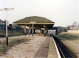
Howe Bridge railway station
Howe Bridge railway station, originally Chowbent station, is a closed railway station in Atherton, Greater Manchester. It was situated within the historic county of Lancashire.-History:...
in 1901. The Lancashire and Yorkshire Railway
Lancashire and Yorkshire Railway
The Lancashire and Yorkshire Railway was a major British railway company before the 1923 Grouping. It was incorporated in 1847 from an amalgamation of several existing railways...
's line from Manchester to Southport passes to the north of Atherton and Atherton Station
Atherton railway station
Atherton railway station serves the town of Atherton, Greater Manchester, and is the main station on the line between Wigan and Manchester on the Manchester to Southport Line, and according to Strategic Rail Authority figures) is the busiest station on the line .The station is located 19 km...
which was opened in 1887–88 remains open.
South Lancashire Tramways
South Lancashire Tramways was a system of electric tramways in south Lancashire authorised by the South Lancashire Tramways Act of 1900. The South Lancashire Tramways Company was authorised by the act to build over of track to serve the towns between St Helens, Swinton, Westhoughton and Hulton...
Company to construct over 62 miles (99.8 km) of tramway in southern Lancashire was given Royal Assent.
However, by November 1900 the South Lancashire Electric Traction and Power Company had acquired the shares. The first section of tramway opened on 20 October 1902 between Lowton
Lowton
Lowton is a village, part of the Metropolitan Borough of Wigan, in Greater Manchester, England. It is around from Leigh and south of Wigan. The settlement lies across the A580 East Lancashire Road....
and Four Lanes Ends via Leigh and Atherton. The company got into financial difficulty and in turn became Lancashire United Tramways later Lancashire United Transport
Lancashire United Transport
Lancashire United Transport was a tram, bus and trolleybus operator based at Howe Bridge in Atherton, 10 miles north west of Manchester...
(LUT). LUT had headquarters and a large depot in Howe Bridge. On 16 December 1933, the last tram ran from Leigh to Four Lane Ends. The following day trolley buses took over.
Public transport
Public transport
Public transport is a shared passenger transportation service which is available for use by the general public, as distinct from modes such as taxicab, car pooling or hired buses which are not shared by strangers without private arrangement.Public transport modes include buses, trolleybuses, trams...
in Atherton is co-ordinated by the Greater Manchester Passenger Transport Executive
Greater Manchester Passenger Transport Executive
Transport for Greater Manchester is the public body responsible for co-ordinating public transport services throughout Greater Manchester, in North West England. The organisation traces its origins to the Transport Act 1968, when the SELNEC Passenger Transport Executive was established to...
.
There are public transport links by rail from Atherton and Hag Fold
Hag Fold railway station
Hag Fold railway station is one of the local stations that lie on the Atherton line, between Wigan and Manchester. The station is located 13 miles west of Manchester Victoria with regular Northern Rail services to these towns as well as Salford, Swinton, Walkden and Hindley.The station was built...
stations to Wigan
Wigan Wallgate railway station
Wigan Wallgate railway station is one of two main railway stations serving the town of Wigan in Greater Manchester, England. The station is on 2 lines, the Manchester-Southport Line and the Manchester-Kirkby Line. It is north west of Manchester Victoria...
and Manchester operated by Northern Rail
Northern Rail
Northern Rail is a British train operating company that has operated local passenger services in Northern England since 2004. Northern Rail's owner, Serco-Abellio, is a consortium formed of Abellio and Serco, an international operator of public transport systems...
, and by bus to Bolton
Bolton
Bolton is a town in Greater Manchester, in the North West of England. Close to the West Pennine Moors, it is north west of the city of Manchester. Bolton is surrounded by several smaller towns and villages which together form the Metropolitan Borough of Bolton, of which Bolton is the...
, Leigh
Leigh, Greater Manchester
Leigh is a town within the Metropolitan Borough of Wigan, in Greater Manchester, England. It is southeast of Wigan, and west of Manchester. Leigh is situated on low lying land to the north west of Chat Moss....
, Wigan
Wigan
Wigan is a town in Greater Manchester, England. It stands on the River Douglas, south-west of Bolton, north of Warrington and west-northwest of Manchester. Wigan is the largest settlement in the Metropolitan Borough of Wigan and is its administrative centre. The town of Wigan had a total...
, Manchester
Manchester
Manchester is a city and metropolitan borough in Greater Manchester, England. According to the Office for National Statistics, the 2010 mid-year population estimate for Manchester was 498,800. Manchester lies within one of the UK's largest metropolitan areas, the metropolitan county of Greater...
, the Trafford Centre
Trafford Centre
The Trafford Centre is a large indoor shopping centre and leisure complex situated in the Metropolitan Borough of Trafford in Greater Manchester, close to the Trafford Park industrial estate and approximately 5 miles from Manchester city centre. It is the highest valued shopping centre in the...
and Middlebrook Retail and Leisure Complex
Middlebrook, Greater Manchester
Middlebrook is a locality that spans the boundaries of Horwich and Lostock in the Metropolitan Borough of Bolton, Greater Manchester, England....
operated by South Lancs Travel
South Lancs Travel
South Lancs Travel is a privately owned bus operator in the districts of Bolton and Wigan in Greater Manchester operating an extensive commercial network along with tendered services on behalf of Transport for Greater Manchester. It also serves some areas of the districts of Salford & Trafford such...
of Atherton and First Manchester
First Manchester
First Manchester is one of the bus companies serving Greater Manchester, a metropolitan county in North West England. It forms part of FirstGroup, a company operating transport services across the British Isles and in North America...
.
Education
The first school in Atherton was Chowbent Grammar School founded before 1654 and followed by Chowbent Chapel School in 1734. Lane Top National SchoolNational school (England and Wales)
A national school was a school founded in 19th century England and Wales by the National Society for Promoting Religious Education.These schools provided elementary education, in accordance with the teaching of the Church of England, to the children of the poor.Together with the less numerous...
opened in 1840 and Chowbent Unitarian School and Hindsford St Anne's in 1860. Howe Bridge School opened in 1869 and St Philip's a year later. An undenominational School in Lee Street opened in 1871 followed by St George's and Sacred Heart School in Hindsford in 1873. In the 1890s, the Technical School originally opened as a school for Science and Art, followed by St Richard's in 1891, and Flapper Fold Higher Grade School in 1893. Green Hall Special School opened in 1957, and a new infant school was opened on Lodge Lane for Sacred Heart. Hesketh Fletcher Senior School opened in 1967 and closed on 31 August 2011.
Religion
Church of St John the Baptist, Atherton
St John the Baptist's Church, Atherton is a church in Atherton, Greater Manchester, England. It is an active Anglican parish church and part of Leigh deanery in the archdeaconry of Salford, diocese of Manchester...
. A chapel dedicated to St John the Baptist at Chowbent was built in 1645 by John Atherton. It is sometimes referred to as the Old Bent Chapel. It remained unconsecrated and was used by the Presbyterians. In 1721 Richard Atherton expelled the dissenters and the chapel was consecrated in 1723 by the Bishop of Sodor and Man
Bishop of Sodor and Man
The Bishop of Sodor and Man is the Ordinary of the Diocese of Sodor and Man in the Province of York in the Church of England. The diocese covers the Isle of Man. The see is in the town of Peel where the bishop's seat is located at the Cathedral Church of St German, elevated to cathedral status on 1...
. A new chapel on the site was consecrated by the bishop of Chester in 1814. The present church was consecrated in 1879. The church, designed by Austin
Hubert Austin
Hubert James Austin was an English architect who practiced in Lancaster. With his partners he designed many churches and other buildings, mainly in the northwest of England.-Early life and career:...
and Paley
Edward Graham Paley
Edward Graham Paley, usually known as E. G. Paley, , was an English architect who practised in Lancaster, Lancashire, in the second half of the 19th century.-Education and career:...
, is built in Runcorn
Runcorn
Runcorn is an industrial town and cargo port within the borough of Halton in the ceremonial county of Cheshire, England. In 2009, its population was estimated to be 61,500. The town is on the southern bank of the River Mersey where the estuary narrows to form Runcorn Gap. Directly to the north...
stone, the interior is Stourton stone with a Yorkshire stone floor. It is 60 feet (18.3 m) wide, 127 feet (38.7 m) long, and the 24 feet (7.3 m) square tower rises to 120 feet (36.6 m). The fabric of the church has suffered from mining subsidence
Subsidence
Subsidence is the motion of a surface as it shifts downward relative to a datum such as sea-level. The opposite of subsidence is uplift, which results in an increase in elevation...
.
The New Bent or Chowbent Chapel
Chowbent Chapel
Chowbent Chapel is a Unitarian place of worship in Atherton, Greater Manchester, England. It was built in 1721 and is the oldest place of worship in the town. It is a member of the General Assembly of Unitarian and Free Christian Churches, the umbrella organisation for British...
, the earliest Nonconformist chapel in Atherton, was built in 1721 and opened in 1722. The chapel was built by the Presbyterian congregation after they were expelled from the first chapel.
St Anne's at Hindsford was originally a mission church occupying a barn which was replaced in 1901 by a church designed by Austin and Paley on Tyldesley Road. It has since been converted to residential use. St Michael and All Angels
St Michael and All Angels' Church, Howe Bridge
St Michael and All Angels' Church, Howe Bridge, is located in Leigh Road, Howe Bridge, a suburb of Atherton, Greater Manchester, England. It is an active Anglican parish church in the deanery of Leigh, the archdeaconry of Salford and the diocese of Manchester...
at Howe Bridge was built in 1877. There are chapels of the Wesleyan
Wesleyanism
Wesleyanism or Wesleyan theology refers, respectively, to either the eponymous movement of Protestant Christians who have historically sought to follow the methods or theology of the eighteenth-century evangelical reformers, John Wesley and his brother Charles Wesley, or to the likewise eponymous...
, Baptist
Baptist
Baptists comprise a group of Christian denominations and churches that subscribe to a doctrine that baptism should be performed only for professing believers , and that it must be done by immersion...
, Independent Methodist, and Primitive Methodist denominations; a Congregational church at Howe Bridge was opened in 1904. Roman Catholics celebrated mass in a loft behind the Star and Garter public house on Tyldesley Square until the Sacred Heart Catholic Church opened in Hindsford in 1869. The site was given by Lord Lilford with building materials donated by John Holland, manager of Yew Tree Colliery in Tyldesley. It served the growing Catholic population in Hindsford and Tyldesley.
Sport
Swimming baths opened in Mayfield Street in 1902 and a swimming club was formed, the baths closed in 2005 and the Atherton & Leigh Amateur Swimming Club moved to the new Leigh Sports VillageLeigh Sports Village
Leigh Sports Village is an £50 million multi-use sports, retail and housing development in Leigh, Greater Manchester, England. Leigh Sports Village plays host to three of the towns sporting clubs. Amateur rugby league club, Leigh East and amateur athletics club, Leigh Harriers occupy dedicated...
facility in 2008.
Atherton has three amateur football teams, the oldest of which is Atherton Collieries A.F.C., formed in 1916, who play in the North West Counties League.
Others are Atherton Laburnum Rovers F.C.
Atherton Laburnum Rovers F.C.
Atherton Laburnum Rovers F.C. are an English football club based in Atherton in Greater Manchester. They play their home matches at Crilly Park, Spa Road. They currently play in the North West Counties Football League Premier Division...
, also members of the North West Counties Football League
and Atherton Town FC.
Public services
Atherton is policed by the Greater Manchester PoliceGreater Manchester Police
Greater Manchester Police is the police force responsible for law enforcement within the metropolitan county of Greater Manchester in North West England...
force from Atherton Police Station,
which covers Atherton, Tyldesley, Astley and Mosley Common.
The statutory emergency fire and rescue service is provided by the Greater Manchester Fire and Rescue Service
Greater Manchester Fire and Rescue Service
Greater Manchester Fire and Rescue Service is the statutory emergency fire and rescue service for the metropolitan county of Greater Manchester, England.Greater Manchester Fire and Rescue Service covers an area of approximately...
,
from Atherton fire station.
Hospital services are provided by the Wrightington, Wigan and Leigh NHS Foundation Trust who provide an Accident and Emergency
Emergency department
An emergency department , also known as accident & emergency , emergency room , emergency ward , or casualty department is a medical treatment facility specialising in acute care of patients who present without prior appointment, either by their own means or by ambulance...
service at Wigan Hospital and outpatient clinics at Leigh Infirmary.
Community health services, including GPs, district and community nurses, dentists and pharmacists, are co-ordinated by
the Ashton, Leigh and Wigan Primary Care Trust.
Waste management is co-ordinated by the Wigan Authority, which is a statutory waste disposal authority in its own right.
Atherton's Distribution Network Operator for electricity is Electricity North West Ltd.
United Utilities manages Atherton's drinking and waste water.
Culture
The Atherton Botanical Garden Club, which is today a social club, was formed in 1850, and organised lectures, study groups and rambles on Chat MossChat Moss
Chat Moss is a large area of peat bog that makes up 30 percent of the City of Salford, in Greater Manchester, England. It is north of the River Irwell, to the west of Manchester, and occupies an area of about...
for its members. A public library was opened in 1905 with an Andrew Carnegie
Andrew Carnegie
Andrew Carnegie was a Scottish-American industrialist, businessman, and entrepreneur who led the enormous expansion of the American steel industry in the late 19th century...
grant. Bent Chapel already had a library in the Chowbent School, and donated 4,000 books to the new town library. Central Park, a 10 acres (4 ha) public park, was created in 1912. Other parks were later provided in Lodge Lane, Hindsford and Devonshire Place. The Urban District Council also acquired the Howe Bridge Welfare grounds in 1963. In the early and mid-20th century Atherton had three cinemas, the Gem in Bullough St, the Savoy, and the Palace on Market Street. An amateur photographic society was formed in 1938. Formby Hall plays host to the Bent 'n' Bongs Beer Festival
Beer festival
A Beer Festival is an organised event during which a variety of beers are available for tasting and purchase. Beer festivals are held in a number of countries...
over the last weekend of every January.
Notable residents
There were several ministers of note of Chowbent Chapel
Chowbent Chapel
Chowbent Chapel is a Unitarian place of worship in Atherton, Greater Manchester, England. It was built in 1721 and is the oldest place of worship in the town. It is a member of the General Assembly of Unitarian and Free Christian Churches, the umbrella organisation for British...
including James Wood
James Wood (minister)
James Wood was a Presbyterian minister of the first Atherton and Chowbent Chapels in Atherton, Greater Manchester, England. During the Jacobite Uprising, he was given the title "The General" for leading a force of men that routed The Highlanders....
, the "General", 1672–1759, who distinguished himself at the Battle of Preston
Battle of Preston (1715)
The Battle of Preston , also referred to as the Preston Fight, was fought during the Jacobite Rising of 1715 ....
in 1715. Thomas Walker Horsfield
Thomas Walker Horsfield
Rev. Thomas Walker Horsfield FSA , was an English Nonconformist minister, topographer, and historian best known for his works The History and Antiquities of Lewes and The History, Antiquities and Topography of the County of Sussex .-Life:He was the eldest of six children of James Horsfield and Ann...
(1792–1837) was a historian and topographer. Joseph Nightingale
Joseph Nightingale
Joseph Nightingale was a prolific English writer and preacher. He was particularly noted for his topographic writing and his interest in shorthand.-Life:...
(1775–1824), born in Chowbent, was a prolific English writer and preacher
Preacher
Preacher is a term for someone who preaches sermons or gives homilies. A preacher is distinct from a theologian by focusing on the communication rather than the development of doctrine. Others see preaching and theology as being intertwined...
who subsequently became a Unitarian.
Eric Roberts Laithwaite (1921–1997) was an engineer, principally known for his development of the linear induction motor
Linear induction motor
A linear induction motor is an AC asynchronous linear motor that works by the same general principles as other induction motors but which has been designed to directly produce motion in a straight line....
and Maglev rail system. Chess grandmaster, Nigel Short
Nigel Short
Nigel David Short MBE is an English chess grandmaster earning the title at the age of 19. Short is often regarded as the strongest English player of the 20th century as he was ranked third in the world, from January 1988 – July 1989 and in 1993, he challenged Garry Kasparov for the World Chess...
grew up in Atherton and attended St Philip's School. Architect Arthur John Hope
Arthur John Hope
Arthur John Hope, known as “AJ” was an architect and president of the Manchester Society of Architects . He was born in Atherton, Greater Manchester, then in the historic county of Lancashire....
(1875–1960), a partner in Bradshaw Gass & Hope
Bradshaw Gass & Hope
Bradshaw Gass & Hope is an English firm of architects founded in 1862 by Jonas James Bradshaw . The style "Bradshaw Gass & Hope" was adopted after J. J...
was born and lived in Atherton. Edward Ormerod
Edward Ormerod
Edward Ormerod was an English mining engineer.Edward Ormerod was born on 2 May 1834 in the village of Church, near Accrington, in Lancashire, England. He worked as a mining engineer at Fletcher, Burrows and Company's Gibfield Colliery in Atherton, Greater Manchester, where he devised and tested a...
, mining engineer at Gib Field Colliery, invented the Ormerod detaching hook, an important mining safety device.