

Water resources management in Chile
Encyclopedia
Water Resources Management (WRM) in Chile
is widely known for its 1981 Water Code—written after General Augusto Pinochet
took control through a military coup d’état. Free-market mechanisms became the economic philosophy in WRM, including the development of water markets and tradable water permits. A major reform to the 1981 Water Code was signed in 2005 to address social equity and environmental protection concerns. Water resources management in Chile is shared among the private sector which provides investment for infrastructure and distribution, and agencies provide regulatory oversight, maintain records, and issue water rights. Chile is negotiating formalized agreements with both Bolivia
and Argentina
to manage shared resources and water storage projects. Chile is also supported in rural water supply with $150 million in loans by the World Bank
and the Inter-American Development Bank
.
Chile has three distinct hydrological regions:
There are a number of important rivers in Chile. The longest river in Chile, the Loa
, is located in the Atacama. The Baker
and BioBío are used for hydropower
, and the Maipo
supplies Santiago with water.
Water quality is quite good in Chile and is recognized for outstanding water supply and sanitation systems. The National Commission of the Environment (CONAMA) set a goal to treat 95% of wastewater by 2010. Point source
pollution from mining effluent and nonpoint source
agricultural runoff is a problem as untreated water discharges into lakes, rivers, and aquifers. Chile has improved in this area since the 1980 declaration to 'live in a pollution free environment'.
Chile has increased exports of fruits and wine requiring improvements and growth in irrigation technology and management. Future hydroelectric projects on the Baker River are in planning stages and should help Chile cope with its energy demands. Hydroelectric projects generate 40% of Chile’s electricity. Copper mining is a major contributor to Chile's GDP and requires large volumes of water; thus creating contention between domestic uses for water and the needs to meet export demands of copper and fruits. Many glaciers exist in Chile and climate change
is increasing the rate of melting. As melting continues, experts agree that hydropower, irrigation, and water supply for human consumption may be diminished.
in that the government granted provisional water rights that became protected property rights after being used. In 1967, a new water code was enacted to replace that of 1951 and was part of Agrarian law reform. The 1967 Water Code was intended to empower landowners to receive water and attempted to redistribute water as a component of the governments strategy to reform agrarian policy. The 1967 Water Code strengthened Government control of water and enabled redistribution of large estates and the expropriation of land and water rights to be reallocated and without any compensation to the previous holders. Land expropriated prior to 1974 was divided into small farms and the rights to land and water were granted to the current occupants, including approximately 48,000 small farmers. These reforms in part, and a deteriorating economic situation led to the military overthrow of Allende
in 1973. The new military government of General Augusto Pinochet
began adopting free-market economic policies and then signed a new constitution in 1980. The 1981 Water Code was soon to follow.
In his book on Chilean water law, "The Siren Song", Carl. J. Bauer provides a balanced critique of the Chilean model with both positive attributes and areas where the model has not worked so well. The problems include poor "environmental protection, river basin management, public interest, social equity, coordination of multiple uses, and resolution of water conflicts". Furthermore, Bauer writes that the legal and institutional framework has become unable to deal with problems related to the model. He goes on by saying that, "the current framework is characterized by a combination of elements that reinforce each other to maintain the status quo:
With support from World Bank and Inter-American Development Bank economists and opposition from command and control proponents, the Chilean model is widely studied and documented for its methods that are at the same time innovative and ideologically divisive. The 1981 Water Code ushered Chile into a regulatory environment based on free-market water management and away from the command and control methods that had failed prior to 1981 to effectively allocate water resources and capture economic gains. Bauer proposed that together with the 1980 constitution, the 1981 water code has been successful in achieving many of its original priorities, especially those strengthening private property rights. Original priorities of the Chilean model according to Bauer include, but are not limited to: "1) security of private property rights to encourage private investment in water use and infrastructure allowing new mining in northern Chile and the planting of high-value fruits and vegetables for export. 2) Tightly restricted government regulation of water use and water management. 3) Freedom to trade water rights to allow reallocation of water resources from low-value use to high-value use where transaction costs are low and water is scarce.
4) Autonomy of private canal users’ associations from the government. This has encouraged organizations to improve their administrative and technical capacity. These associations primarily operate in the agricultural sector. 5) Creation of non-consumptive water rights to encourage hydropower developments".
Summarized below, power sharing and divided responsibility are hallmarks of the 1981 Water Code:
Major aspects of the 2005 reform include: 1) Giving the President authority to exclude water resources from economic competition in cases where necessary to protect the public interest. 2) Obliging the General Directorate of Water Resources (DGA) to consider environmental aspects in the process of establishing new water rights, especially in terms of determining ecological water flows and protecting sustainable aquifer management. 3) Charging a license fee for unused water rights and limiting requests for water use rights to genuine needs, as a deterrent against hoarding and speculation.
Important dates during the fifteen-year water code reform process:
Source: Peña, Humberto. Ministry of Public Works : Chile
Water trading
, is not a common practice in most areas of Chile and individuals do not have expectations that they can resolve their water allocation problems through water market transfers. This is due to problematic distribution between markets, cultural norms that couple land and water rights together, the urbanization of irrigated land, and high transaction costs in many areas including expenses in titling unregistered rights, information costs, costs to modify infrastructure, and the opportunity cost of time invested in the transaction.
While not widespread throughout Chile, water markets have been well documented in the areas where they have been implemented. Studies have shown active trading for water use rights in the Limari Valley, where water is scarce with a high economic value, especially for the emerging agricultural sector. Trading between sectors has transferred water to growing urban areas in the Elqui
Valley and the upper Mapocho watershed, where water companies and real estate developers are continuously buying water and accounted for 76% of water rights traded between 1993 and 1999. In contrast, water markets and trading has been more limited in the BioBio, Aconcagua
and Cachapoal Valleys.
The prevailing wisdom from the IDB, and the World Bank is that water markets in Chile have been a success. In some regions of Chile, water markets have been successful at achieving the original objectives of reallocating water to higher-value uses and capturing economic efficiencies through trading. Humberto Peña, the former Director of the General Water Directorate (DGA) in Chile, offers an opposing opinion while claiming that the scarcity of trading implies that water markets do not effectively redistribute water.
In water pricing, two elements need to be distinguished: the price of untreated water at the source, and the price of treated water delivered to the final user. In most countries the use of water at the source is free and the price of water recovers part or all of the costs of treating and delivering it. Chile is an exception however; as the 1981 Water Code not only confirmed private property rights to water resources, but also allowed their sale, thus creating a water market and allowing the establishment of prices for water resources. Supply and demand were supposed to determine the allocated water and its price at the source. Price increases that range from 41% to 240% between the years of 1986-2000 are only one indicator that market forces are at play in determining what activities are high-value and those that are not.
Water tariffs that are charged by utilities to treat and supply water to residential and commercial users have to be clearly distinguished from the pricing of water resources.
See:Water tariffs in Chile
Chile is characterized by irregular distribution of rainfall totals among three distinct climate regions: the Atacama Desert
in the northern region, the temperate and Mediterranean
central region, and the cold and rainy southern region. The dry Atacama Desert region receives an average of 44.5 mm of precipitation annually while the southern regions receive 3000 mm of annual precipitation on average. According to FAO
, average annual precipitation is 1,522 mm with an annual volume of 1,152 km3. From this total volume, 884 km3 will runoff while 268 km3 will evaporate from rivers, lakes and reservoirs.
Chile's rivers are generally short, running from the Andes in the East to the Pacific in the West. The most important rivers in Chile are the Loa River
in the Northern Atacama desert
, the country's longest river with a length of 420 km that has suffered pollution from copper mining; the Baker River
in Patagonia, the country's largest river in terms of discharge that is the site of Chile's largest planned hydropower plant with a capacity of 2,400 Megawatts; the Biobío River, the country's second longest river that became famous for the construction of controversial Pangue dam in 1996; the Maule River
in the central part of Chile that is well known for its agriculture, including its irrigated vineyards, as well at the literature and poetry it has inspired; and the Maipo River
that provides the capital Santiago with drinking water and is also a major source of water for irrigation.
Groundwater usage from aquifers in Chile is notably much less than of surface water. As of 1999, only 1.455 km3 was pumped out of aquifers that are recharged by nine prominent watersheds in Chile.
The table below further distinguishes among fifteen administrative regions of Chile and their main hydrological characteristics.
See also Regions of Chile
Regions I through XV correspond to Northern Chile (drier) down to Southern Chile (wetter) respectively. NOTE: *Region XIV is between IX and X; ** Region XV is northernmost.
Source for tables above: FAO (2000) data updated with 2002 census figures; ***The Global Precipitation Climatology Project (GPCP) (2006)
(See also List of lakes in Chile)
Natural storage. Chile has a large number of natural lakes with an approximate capacity of 7 km³. The southern regions are home to numerous lakes and lagoons, some shared with Argentina. Population density is very low in southern Chile (0.1 to 0.6 persons/km²), therefore demand for water and development of the water resources is minimal.
also received torrential rain for more than three consecutive days in September 2008 causing severe flooding and the declaration of another emergency.
pollution from mining effluent is a problem. Because there is not much water in rivers, dilution of contaminants is greatly reduced. In Central Chile industrial pollution is an issue. Very often these discharges go untreated directly into river basins, lakes, and irrigation channels. Nonpoint source
pollution from agricultural runoff including nitrates from fertilizers and untreated sewage is contaminating underground waters. The severity of the problem has yet to be thoroughly quantified.
In Chile, water is safe to drink, with ~99% of water service providers complying with bacteriological and disinfection norms. In a 2006 report on water quality management in Chile, the authors reported that in 2000, 99.1 percent of the urban population and 72.3 percent of the rural population had access to drinking water.
Water quality in Chile has steadily increased after the 'right to live in a pollution free environment' mentioned above was written into the 1980 Constitution, however, water pollution is still a concern. This is mostly due to point-source discharges of untreated domestic and industrial wastewaters.
In the early 1990s, domestic and industrial wastewater discharge totaled approximately 43 cubic meters per second (1,520 ft3/s) with domestic contamination representing 56% of this total and industrial effluent at 44%.
The problem was compounded by a lack of chlorination systems among water service providers. Therefore, 20% of water service providers in 1991 did not comply with bacteriological norms. From its inception in 1990, the Superintendencia de Servicios Sanitarios (SISS) put greater attention and effort towards increasing the number of adequate chlorination systems. By 2006, improvements were made regarding chlorination systems and only 1% of water service providers were non-compliant. Furthermore, compliance with disinfection norms increased from 89% to more than 99% in 2006 through similar effort.
Improvements have also been made in wastewater treatment over recent decades as the National Commission of the Environment (CONAMA) set in motion a policy that has seen treatment programs for raw domestic wastewaters increase to 80% in 2006 and 95% by 2010. CONAMA also sought to expand industrial wastewater treatment to 50% of these discharges by 2006. As of 2006, nonpoint source pollution, mainly from agriculture, had not yet been quantified.
It should be noted that CNR includes 730,000 hectares of "eventual" irrigated land in their figure of 1.8 million hectares. Only 3% of surface area in Chile is agricultural land, and this sector accounts for only 4.8% of Chile's GDP. Employment in the agricultural sector in 2005 stands at 13.2% of the total labor force. The primary crops grown in Chile are grapes, apples, peaches, wheat, corn, and oats. Most of Chile's crops are grown in the central regions considered the agricultural heartland due to its temperate growing climate.
Chile made a conscious decision to produce high-quality products for the international market, therefore, increasing their annual exports. To achieve this, improvements in irrigation and water management systems were implemented to grow grapes, other fruits, cereals, and vegetables. Additionally, over two decades of research and examination by Humberto Peña has revealed the use of wells in agriculture has increased sixfold. A 1986 law provided subsidies for irrigated lands and was later revised to specifically target poorer farmers. Because of these policies, production increased by $353 million, while water-use efficiency was also drastically improved. Surplus water is used for other purposes such as replenishing natural water bodies to support ecosystem services.
The 1980 Constitution specified for the creation of water rights for non-consumptive use (hydropower) of water and this encouraged hydroelectric power developments. Initially, this created dispute between consumptive-use (irrigation) and electricity generators as to when release of water should be scheduled. The Supreme Court eventually ruled in favor of non-consumptive use because it has a higher value and greater potential to create economic growth.
Existing dams. Dam Capacity in Chile is roughly 4.66 km3 while hydropower represents ~40% of the total electricity production. This equates to approximately 4.8 GW of annual hydropower production. In 1992, Chile extracted 63 km3 of water throughout the country and of this total, 67.8% was used to generate hydroelectric energy.
Planned dams. In 2009 hydroelectric projects are being developed by electric companies, Endesa
and Colbún
. The two companies formed a joint venture called HidroAysén
. The Aysén project proposes to build five dams on the Baker River
and Pascua River
at a cost of US $4 billion with an installed capacity of 2,400–2,750 MW. The HidroAysén project is being opposed by the Natural Resources Defense Council
(NRDC), Ecosistemas, the Citizen Coalition for Aysen Life Reserve, and Chilean celebrities. The opposition argues the project would be environmentally devastating, lead to more destructive projects, ruin pristine ecosystems, and that alternatives such as conservation policies remain to be instituted.
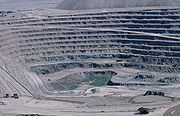 Chile has emerged as the world's number one copper producer and exports have tripled since the early in 1980s. Primarily mined and processed in the Atacama Desert, copper mining historically uses large quantities of water. In 2008 and 2009, copper miners have reduced water use on the heels of Chile's worst drought in decades. Water being key ingredient in various stages of copper extraction, miners will consume 11.5 m3/s (410 ft3/s) of water on average, down from 15 m3/s (530 ft3/s) in 2000. Growing competition for water between mining, cities and farmers has led to an increase in the value of water in Chile.
A relevant sidenote, US trained free-market economists instrumental in re-writing Chilean laws in the 1970s known as the “Chicago Boys
”, advised the Chilean government that market mechanisms could perhaps motivate users to save water, sell their surplus, and transfer water rights to higher value users in other sectors.
Maintained by the DGA, the Water Cadastre contains information on all water use rights granted by the DGA. Additionally, the water cadastre contains hydrological and water quality data, information on water user associations (WUA's), water withdrawals, and all other transactions. According to Robert R. Hearne and Guillermo Donoso, this cadastre
does not imply legal title and often is incomplete.
Water Works Directorate (DOH)- Under the Ministry of Public Works, the DOH is responsible for the direction of the Rural Water Supply Program. Additionally, the DOH provides assistance in the construction and maintenance of major water supply including irrigation and drainage infrastructure.
National Commission of the Environment (CONAMA)- This commission serves as a coordinator of national environmental policy, water quality, and environment conservation. In the case of water quality management, CONAMA has established emission standards for discharges of wastewaters into sewerage systems, surface and groundwater and enforcement policies, penalties and fines for non compliance.
Superintendent of Sanitary Services (SISS)- This is a regulation and auditing agency of providers of drinking water and sanitation services in urban areas. SISS sets rates for sanitary services for the economy ministry, oversees compliance with norms, and regulates the control of environmental waste.
National Irrigation Commission (CNR)- Created in 1975, CNR is a legal body under public law. The primary objective of CNR is to develop and improve irrigation and drainage infrastructure throughout Chile.
A historical snapshot of Legal and Institutional Changes in the Water Sector (1977–2005):
Source: Peña, Humberto. Ministry of Public Works : Chile
to be a global framework on negotiating this kind of agreement. In May 2009, representatives from Argentina and Chile met to formalize a request to their respective Ministers of Foreign Affairs. The request asks that the objectives of the 1991 protocol of shared water resources be complied with. Objectives in Article I of the protocol state, "the parties shall agree that the actions and programs concerning the use of shared water resources be undertaken under the concept of integrated management of the watersheds."
With Bolivia. Historically, there had not been agreements regarding water resources with Peru or Bolivia. Furthermore, Bolivia and Chile have been feuding over the use of the Silala waters for many years. Bolivian officials allege that because the Silala waters are born from 94 springs in Bolivia, it should be compensated by Chile for their use of the water. Chile and Bolivia were reported to be close to an initial agreement following a meeting in Santiago on April 3, 2009. The agreement would require Chile to pay for 50% of the Silala waters, to be paid by Chile's state copper company Codelco
and by Ferrocarril Andino
, a Chilean group investing in rail. Additionally, Bolivia's foreign relations minister David Choquehuanca
has proposed a daily extraction fee totaling about US$6 million per year. Talks have continued in May 2009 to advance details of the international water sharing agreement.
According to the British Foreign and Commonwealth office, Chile is the planet’s ninth most vulnerable country to climate change. This office adds, "glacial melt, shifts in rainfall patterns, expanding deserts, and greater frequency in El Niño will have an impact on water supply."
Much of Chile is dominated by the Andes
Mountain range and many high altitude glaciers. With rising temperatures, the IPCC
warns of increased melting for many of these glaciers, with some of them disappearing as early as 2020–2030. The Third Assessment Report from the IPCC indicate a critical situation for glaciers in neighboring countries such as Bolivia and Peru. The IPCC report goes on to say that glaciers in Chile are drastically reducing their volume at an increasing rate and that changes in temperature and humidity are the primary cause. In an article from Science Daily
in March 2008, the news agency reports that, "if the inter-tropical glaciers of Chile, Argentina
, and Colombia
disappear, water availability and hydropower generation will be affected." Of the thirty test glaciers monitored in the Andes by the World Glacier Monitoring Service
(WGMS) only Chile's Echaurren Norte glacier thickened between 2005 and 2006.
Offnews, a sustainable development
news forum from Buenos Aires
, has aggregated climate change reports and predictions from the IPCC, the World Economic Forum
, the UN Economic Commission for Latin America and the Caribbean, the University of Chile, and the Chilean government. Projections in the reporting of Offnews indicate that most of Chile will see a sharp reduction in rainfall. The one exception to reduced rainfall is in northern Atacama desert where increased rainfall is projected.
(OECD) has analyzed the status of species in Chile and report that 41 of 44 vertebrate freshwater species are encountering conservation problems. Possible reasons include low environmental flows, climate change impacts, and mining effluents, but direct links have not been established. There are seven UNESCO biosphere reserve
s, nine Ramsar
(convention on wetlands) sites, and three World Heritage Site
s in a network of protected areas in Chile.
Ramsar
sites in Chile:
article, "virtual transfer" of water out of Chile when exporting copper and fruit is substantial at around 1,900 million m3 per year. This equates to approximately 1.4 times the amount of drinking water produced per year in the country.
approved a US$50 million loan to support a US$90 million project for rural infrastructure services. The Infrastructure for Territorial Development Project for Chile aims to increase the effective and productive use of sustainable infrastructure services by poor rural communities. 30% of the project cost or approximately US$27 million is appropriated to water, sanitation, and flood protection projects. The project is scheduled to close in June 2010.
In 2007 the Inter-American Development Bank
(IDB) approved US$100 million loan for a US$200 million project to improve potable water and sanitation services in rural communities throughout Chile. More specifically, disposal and treatment of wastewater will be upgraded with new treatment facilities in rural areas, and improved potable water distribution systems will be constructed. Institutional strengthening is a major component of the program. The Ministry of Planning will determine technical and economic feasibility of eligible project proposals and the program will be carried out by the Subsecretary of Regional Development.
Chile
Chile ,officially the Republic of Chile , is a country in South America occupying a long, narrow coastal strip between the Andes mountains to the east and the Pacific Ocean to the west. It borders Peru to the north, Bolivia to the northeast, Argentina to the east, and the Drake Passage in the far...
is widely known for its 1981 Water Code—written after General Augusto Pinochet
Augusto Pinochet
Augusto José Ramón Pinochet Ugarte, more commonly known as Augusto Pinochet , was a Chilean army general and dictator who assumed power in a coup d'état on 11 September 1973...
took control through a military coup d’état. Free-market mechanisms became the economic philosophy in WRM, including the development of water markets and tradable water permits. A major reform to the 1981 Water Code was signed in 2005 to address social equity and environmental protection concerns. Water resources management in Chile is shared among the private sector which provides investment for infrastructure and distribution, and agencies provide regulatory oversight, maintain records, and issue water rights. Chile is negotiating formalized agreements with both Bolivia
Bolivia
Bolivia officially known as Plurinational State of Bolivia , is a landlocked country in central South America. It is the poorest country in South America...
and Argentina
Argentina
Argentina , officially the Argentine Republic , is the second largest country in South America by land area, after Brazil. It is constituted as a federation of 23 provinces and an autonomous city, Buenos Aires...
to manage shared resources and water storage projects. Chile is also supported in rural water supply with $150 million in loans by the World Bank
World Bank
The World Bank is an international financial institution that provides loans to developing countries for capital programmes.The World Bank's official goal is the reduction of poverty...
and the Inter-American Development Bank
Inter-American Development Bank
The Inter-American Development Bank is the largest source of development financing for Latin America and the Caribbean...
.
Chile has three distinct hydrological regions:
- The dry northern regions, including the Atacama DesertAtacama DesertThe Atacama Desert is a plateau in South America, covering a strip of land on the Pacific coast, west of the Andes mountains. It is, according to NASA, National Geographic and many other publications, the driest desert in the world...
, one of the driest places on earth - The central regions are temperate and support the largest population centers of SantiagoSantiago, ChileSantiago , also known as Santiago de Chile, is the capital and largest city of Chile, and the center of its largest conurbation . It is located in the country's central valley, at an elevation of above mean sea level...
and ValparaísoValparaísoValparaíso is a city and commune of Chile, center of its third largest conurbation and one of the country's most important seaports and an increasing cultural center in the Southwest Pacific hemisphere. The city is the capital of the Valparaíso Province and the Valparaíso Region... - The sparsely populated southern provinces receive large quantities of rain and snow.
There are a number of important rivers in Chile. The longest river in Chile, the Loa
Loa
The Loa are the spirits of the voodoo religion practiced in Louisiana, Haiti, Benin, and other parts of the world. They are also referred to as Mystères and the Invisibles, in which are intermediaries between Bondye —the Creator, who is distant from the world—and humanity...
, is located in the Atacama. The Baker
Baker
A baker is someone who bakes and sells bread, Cakes and similar foods may also be produced, as the traditional boundaries between what is produced by a baker as opposed to a pastry chef have blurred in recent decades...
and BioBío are used for hydropower
Hydropower
Hydropower, hydraulic power, hydrokinetic power or water power is power that is derived from the force or energy of falling water, which may be harnessed for useful purposes. Since ancient times, hydropower has been used for irrigation and the operation of various mechanical devices, such as...
, and the Maipo
Maipo
Maipo may refer to:*Maipo, Chile, a town in Buin, Chile*Maipo , a volcano on the border of Argentina and Chile*Maipo River, the river that rises on the west slope Maipo volcano and flows through the Santiago Metropolitan Region of Chile...
supplies Santiago with water.
Water quality is quite good in Chile and is recognized for outstanding water supply and sanitation systems. The National Commission of the Environment (CONAMA) set a goal to treat 95% of wastewater by 2010. Point source
Point source
A point source is a localised, relatively small source of something.Point source may also refer to:*Point source , a localised source of pollution**Point source water pollution, water pollution with a localized source...
pollution from mining effluent and nonpoint source
Nonpoint source pollution
Nonpoint source pollution refers to both water and air pollution from diffuse sources. Nonpoint source water pollution affects a water body from sources such as polluted runoff from agricultural areas draining into a river, or wind-borne debris blowing out to sea. Nonpoint source air pollution...
agricultural runoff is a problem as untreated water discharges into lakes, rivers, and aquifers. Chile has improved in this area since the 1980 declaration to 'live in a pollution free environment'.
Chile has increased exports of fruits and wine requiring improvements and growth in irrigation technology and management. Future hydroelectric projects on the Baker River are in planning stages and should help Chile cope with its energy demands. Hydroelectric projects generate 40% of Chile’s electricity. Copper mining is a major contributor to Chile's GDP and requires large volumes of water; thus creating contention between domestic uses for water and the needs to meet export demands of copper and fruits. Many glaciers exist in Chile and climate change
Climate change
Climate change is a significant and lasting change in the statistical distribution of weather patterns over periods ranging from decades to millions of years. It may be a change in average weather conditions or the distribution of events around that average...
is increasing the rate of melting. As melting continues, experts agree that hydropower, irrigation, and water supply for human consumption may be diminished.
Water management history
Beginning in 1855, the State Civil Code granted licenses to private parties for exclusive use of water. Nearly one hundred years later, Chile adopted the 1951 Water Code that provided a system of water rights administration very similar to that practiced in the Western United StatesWestern United States
.The Western United States, commonly referred to as the American West or simply "the West," traditionally refers to the region comprising the westernmost states of the United States. Because the U.S. expanded westward after its founding, the meaning of the West has evolved over time...
in that the government granted provisional water rights that became protected property rights after being used. In 1967, a new water code was enacted to replace that of 1951 and was part of Agrarian law reform. The 1967 Water Code was intended to empower landowners to receive water and attempted to redistribute water as a component of the governments strategy to reform agrarian policy. The 1967 Water Code strengthened Government control of water and enabled redistribution of large estates and the expropriation of land and water rights to be reallocated and without any compensation to the previous holders. Land expropriated prior to 1974 was divided into small farms and the rights to land and water were granted to the current occupants, including approximately 48,000 small farmers. These reforms in part, and a deteriorating economic situation led to the military overthrow of Allende
Salvador Allende
Salvador Allende Gossens was a Chilean physician and politician who is generally considered the first democratically elected Marxist to become president of a country in Latin America....
in 1973. The new military government of General Augusto Pinochet
Augusto Pinochet
Augusto José Ramón Pinochet Ugarte, more commonly known as Augusto Pinochet , was a Chilean army general and dictator who assumed power in a coup d'état on 11 September 1973...
began adopting free-market economic policies and then signed a new constitution in 1980. The 1981 Water Code was soon to follow.
The Chilean water management model and 1981 Water Code
Protected by Chile’s 1980 Constitution, the 1981 Water Code established the framework by which the allocation and management of water resources are employed in Chile. Internationally known as the "Chilean Model", the Chilean experience in water resources management is characterized by its use of free-market forces and water markets to reallocate water to high-value use. Although private water rights existed in Chile prior to 1981, the previous water codes restricted the creation and operation of an efficient water market. When the Water Code was being drafted in the late 1970s and early 1980s, the government was concerned with irrigation and agriculture. The framers of the 1981 Water Code sought to achieve the efficiencies of market reallocation of water within agricultural and irrigation markets. As Hernan Buchi, ex-Finance Minister of Chile (1985–1989), stated, “the objective of the governmental action in this field was to create solid water use rights in order to facilitate the proper operation of the market as an allocation mechanism”.In his book on Chilean water law, "The Siren Song", Carl. J. Bauer provides a balanced critique of the Chilean model with both positive attributes and areas where the model has not worked so well. The problems include poor "environmental protection, river basin management, public interest, social equity, coordination of multiple uses, and resolution of water conflicts". Furthermore, Bauer writes that the legal and institutional framework has become unable to deal with problems related to the model. He goes on by saying that, "the current framework is characterized by a combination of elements that reinforce each other to maintain the status quo:
- strong and broadly defined private economic rights
- tightly restricted regulatory authority
- a powerful but erratic judiciary untrained in public policy issues and holding a narrow and formalistic conception of the law".
With support from World Bank and Inter-American Development Bank economists and opposition from command and control proponents, the Chilean model is widely studied and documented for its methods that are at the same time innovative and ideologically divisive. The 1981 Water Code ushered Chile into a regulatory environment based on free-market water management and away from the command and control methods that had failed prior to 1981 to effectively allocate water resources and capture economic gains. Bauer proposed that together with the 1980 constitution, the 1981 water code has been successful in achieving many of its original priorities, especially those strengthening private property rights. Original priorities of the Chilean model according to Bauer include, but are not limited to: "1) security of private property rights to encourage private investment in water use and infrastructure allowing new mining in northern Chile and the planting of high-value fruits and vegetables for export. 2) Tightly restricted government regulation of water use and water management. 3) Freedom to trade water rights to allow reallocation of water resources from low-value use to high-value use where transaction costs are low and water is scarce.
4) Autonomy of private canal users’ associations from the government. This has encouraged organizations to improve their administrative and technical capacity. These associations primarily operate in the agricultural sector. 5) Creation of non-consumptive water rights to encourage hydropower developments".
Summarized below, power sharing and divided responsibility are hallmarks of the 1981 Water Code:
- The executive power of the government is charged with the authority to plan, regulate, and promote the appropriate use of all water.
- Private stakeholders have greater power to invest in both domestic and agricultural water uses, water system maintenance, and play a role in the management of water supply and sanitation.
- Under the Ministry of Public Works, the Water Directorate carries out all measurement, research, and is authorized to grant water use rights.
- The Water Cadastre under the Water Directorate records all water rights and transactions.
2005 Water Code reform
The reform of the 1981 Water Code was passed in 2005 to address social equity and environmental concerns. For example, while efficiencies were gained and investment increased, the allocation of water rights without limits started to create problems such as the monopolizing of water rights for surplus, speculation, and to prevent competition into various markets. Details of the reform involved fifteen years of meetings, negotiation, disputes, and concessions. Throughout the political struggle to reform the Water code, the government's position on water markets became more favorable and they proposed reforms in response to strong political opposition from conservative political parties and private sector business interests.Major aspects of the 2005 reform include: 1) Giving the President authority to exclude water resources from economic competition in cases where necessary to protect the public interest. 2) Obliging the General Directorate of Water Resources (DGA) to consider environmental aspects in the process of establishing new water rights, especially in terms of determining ecological water flows and protecting sustainable aquifer management. 3) Charging a license fee for unused water rights and limiting requests for water use rights to genuine needs, as a deterrent against hoarding and speculation.
Important dates during the fifteen-year water code reform process:
- 1992 The government introduced the first reform project
- 1996 The government made amendments and introduced a second project
- 1997 Water reform approved by Chamber of Representatives
- 1999 Reform was approved in Senate Committees
- 2000 Reform was approved (in general) by the Senate
- 2004 Reform was approved (in detail) in Senate Committees
- 2005 Final project was approved unanimously in both chambers to address social equity and environmental sustainability concerns
Source: Peña, Humberto. Ministry of Public Works : Chile
Water Markets
New water rights are granted by the General Water Directorate (DGA). When competition for solicited water rights arises, they are allocated through an auction with rights awarded to the highest bidder. An example of average annual water volumes traded between 1993 and 1998 in the Maipo and Mapocho regions recorded transfers of 821 L per/s and 161 L per/s respectively.Water trading
Water trading
Water trading is the process of buying and selling of water access entitlements, also often called water rights. The terms of the trade can be either permanent or temporary, depending on the legal status of the water rights. Some of the western states of the United States, Chile, South Africa,...
, is not a common practice in most areas of Chile and individuals do not have expectations that they can resolve their water allocation problems through water market transfers. This is due to problematic distribution between markets, cultural norms that couple land and water rights together, the urbanization of irrigated land, and high transaction costs in many areas including expenses in titling unregistered rights, information costs, costs to modify infrastructure, and the opportunity cost of time invested in the transaction.
While not widespread throughout Chile, water markets have been well documented in the areas where they have been implemented. Studies have shown active trading for water use rights in the Limari Valley, where water is scarce with a high economic value, especially for the emerging agricultural sector. Trading between sectors has transferred water to growing urban areas in the Elqui
Valley and the upper Mapocho watershed, where water companies and real estate developers are continuously buying water and accounted for 76% of water rights traded between 1993 and 1999. In contrast, water markets and trading has been more limited in the BioBio, Aconcagua
Aconcagua
Aconcagua is the highest mountain in the Americas at . It is located in the Andes mountain range, in the Argentine province of Mendoza and it lies west by north of its capital, the city of Mendoza. The summit is also located about 5 kilometres from San Juan Province and 15 kilometres from the...
and Cachapoal Valleys.
The prevailing wisdom from the IDB, and the World Bank is that water markets in Chile have been a success. In some regions of Chile, water markets have been successful at achieving the original objectives of reallocating water to higher-value uses and capturing economic efficiencies through trading. Humberto Peña, the former Director of the General Water Directorate (DGA) in Chile, offers an opposing opinion while claiming that the scarcity of trading implies that water markets do not effectively redistribute water.
In water pricing, two elements need to be distinguished: the price of untreated water at the source, and the price of treated water delivered to the final user. In most countries the use of water at the source is free and the price of water recovers part or all of the costs of treating and delivering it. Chile is an exception however; as the 1981 Water Code not only confirmed private property rights to water resources, but also allowed their sale, thus creating a water market and allowing the establishment of prices for water resources. Supply and demand were supposed to determine the allocated water and its price at the source. Price increases that range from 41% to 240% between the years of 1986-2000 are only one indicator that market forces are at play in determining what activities are high-value and those that are not.
Water tariffs that are charged by utilities to treat and supply water to residential and commercial users have to be clearly distinguished from the pricing of water resources.
See:Water tariffs in Chile
Surface and groundwater resources
See also List of rivers of ChileChile is characterized by irregular distribution of rainfall totals among three distinct climate regions: the Atacama Desert
Atacama Desert
The Atacama Desert is a plateau in South America, covering a strip of land on the Pacific coast, west of the Andes mountains. It is, according to NASA, National Geographic and many other publications, the driest desert in the world...
in the northern region, the temperate and Mediterranean
Mediterranean climate
A Mediterranean climate is the climate typical of most of the lands in the Mediterranean Basin, and is a particular variety of subtropical climate...
central region, and the cold and rainy southern region. The dry Atacama Desert region receives an average of 44.5 mm of precipitation annually while the southern regions receive 3000 mm of annual precipitation on average. According to FAO
Fão
Fão is a town in Esposende Municipality in Portugal....
, average annual precipitation is 1,522 mm with an annual volume of 1,152 km3. From this total volume, 884 km3 will runoff while 268 km3 will evaporate from rivers, lakes and reservoirs.
Chile's rivers are generally short, running from the Andes in the East to the Pacific in the West. The most important rivers in Chile are the Loa River
Loa River
The Loa River is a U-shaped river in Chile's northern Antofagasta Region. At 440 km long it is the country's longest river and the main watercourse in the Atacama Desert.-Course:...
in the Northern Atacama desert
Atacama Desert
The Atacama Desert is a plateau in South America, covering a strip of land on the Pacific coast, west of the Andes mountains. It is, according to NASA, National Geographic and many other publications, the driest desert in the world...
, the country's longest river with a length of 420 km that has suffered pollution from copper mining; the Baker River
Baker River (Chile)
The Baker River is a river located in the Aisén Region of the Chilean Patagonia. It is Chile's largest river in terms of volume of water. The river flows out of Bertrand Lake, which is fed by General Carrera Lake. It runs along the east side of the Northern Patagonian Ice Field and empties into the...
in Patagonia, the country's largest river in terms of discharge that is the site of Chile's largest planned hydropower plant with a capacity of 2,400 Megawatts; the Biobío River, the country's second longest river that became famous for the construction of controversial Pangue dam in 1996; the Maule River
Maule river
The Maule river is one of the most important rivers of Chile and is inextricably linked to this country's pre-Hispanic times, the country's conquest, colonial period, wars of Independence, modern history, agriculture , culture , religion, economy and politics...
in the central part of Chile that is well known for its agriculture, including its irrigated vineyards, as well at the literature and poetry it has inspired; and the Maipo River
Maipo River
Maipo River is the main river flowing through Santiago Metropolitan Region, Chile. Its headwaters are on the west slope of Maipo volcano, in the Andes. Its most famous tributary is Mapocho River. The Maipo River is by far the major source of irrigation and potable water for the region.-Course:In...
that provides the capital Santiago with drinking water and is also a major source of water for irrigation.
Groundwater usage from aquifers in Chile is notably much less than of surface water. As of 1999, only 1.455 km3 was pumped out of aquifers that are recharged by nine prominent watersheds in Chile.
The table below further distinguishes among fifteen administrative regions of Chile and their main hydrological characteristics.
See also Regions of Chile
Regions I through XV correspond to Northern Chile (drier) down to Southern Chile (wetter) respectively. NOTE: *Region XIV is between IX and X; ** Region XV is northernmost.
| Administrative Region | Population (2002 census data) | Surface km2 | Main Rivers | Average annual rainfall (mm) | Average annual runoff (mm) | Per capita average annual renewable water resources m3 |
|---|---|---|---|---|---|---|
| I - Tarapacá Tarapacá Region The I Tarapacá Region is one of Chile's 15 first order administrative divisions. It borders the Chilean Arica and Parinacota Region to the north, Bolivia's Oruro Department on the east, the Antofagasta Region on the south and the Pacific Ocean on the west. The port city of Iquique The I Tarapacá... |
428,594 | 58,698 | Azapa River, Vítor River and Camarones River Camarones River -References:*... |
93.6 | 7.1 | 972 |
| II - Antofagasta Antofagasta Region The II Antofagasta Region is one of Chile's fifteen first-order administrative divisions. It comprises three provinces, Antofagasta, El Loa and Tocopilla... |
493,984 | 126,444 | Loa River Loa River The Loa River is a U-shaped river in Chile's northern Antofagasta Region. At 440 km long it is the country's longest river and the main watercourse in the Atacama Desert.-Course:... |
44.5 | 0.2 | 51 |
| III - Atacama Atacama Region The Atacama Region is one of Chile's 15 first order administrative divisions. It comprises three provinces, Chañaral, Copiapó and Huasco. It is bordered to the north by Antofagasta, to the south by Coquimbo, to east with Provinces of Catamarca, La Rioja and San Juan of Argentina, and to west with... |
254,336 | 75,573 | Salado River Salado River The Salado River is a river that crosses several provinces of Argentina, flowing from its source in the Salta Province to end in the Paraná River, in the Santa Fe Province. Because its origin, its flow varies widely within the year, and it can dry out in some parts of its path during the winter... |
82.4 | 0.7 | 208 |
| IV - Coquimbo Coquimbo Region The IV Coquimbo Region is one of Chile's 15 first order administrative divisions. It is some 400 km north of the capital, Santiago.The capital and largest city is La Serena, other important cities include the seaport Coquimbo and the agricultural centre... |
603,210 | 40,656 | Elqui River Elqui River The Elqui River starts in the west Andes, flowing into the Pacific Ocean, crossing the Chilean city of La Serena, is a wine and pisco producing area... , Choapa River Choapa River Choapa River or El Río Choapa is a river of Chile located in the Coquimbo Region. The river rises in the Andes, at the confluence of the streams Totoral, Leiva and Del Valle. The river then flows through the town of Salamanca before it meets with its main tributary, the Illapel River... and Limarí River Limarí River Limarí River is a river of Chile located in the Coquimbo Region. The river is formed at the confluence of the Hurtado and Grande rivers, about 4 km east of the city of Ovalle. The lower course of the river borders the southern portion of Bosque de Fray Jorge National Park... |
222 | 18 | 1,213 |
| V - Valparaíso Valparaíso Region The V Valparaíso Region is one of Chile's 15 first order administrative divisions.Valparaíso Region, 2006 With the country's third highest population of 1,539,852 million in 2002 and third smallest area of , the region is Chile's second most densely populated after the Santiago Metropolitan Region... |
1,539,852 | 16,396 | Petroca River, Ligua River and Aconcagua River Aconcagua River For other uses, see Aconcagua .The Aconcagua River is a river in Chile that rises from the joint of two minor tributary rivers at above sea level in the Andes, Juncal river from the east and Blanco river from the south east... |
434 | 84 | 894 |
| Metro Region(MR) - Santiago Metropolitan Santiago Metropolitan Region Santiago Metropolitan Region or simply Metropolitan Region is one of Chile's 15 first order administrative divisions. It is the country's only landlocked administrative region and contains the nation's capital, Santiago... |
7,003,122 | 15,349 | Maipo River Maipo River Maipo River is the main river flowing through Santiago Metropolitan Region, Chile. Its headwaters are on the west slope of Maipo volcano, in the Andes. Its most famous tributary is Mapocho River. The Maipo River is by far the major source of irrigation and potable water for the region.-Course:In... |
650 | 200 | 438 |
| VI - O'Higgins O'Higgins Region The VI O'Higgins Region is one of Chile's 15 first order administrative divisions. It is subdivided into three provinces. It is named in honour of Bernardo O'Higgins Riquelme, one of Chile's founding fathers.... |
780,627 | 16,341 | Cachapoal River Cachapoal River Cachapoal River is tibutary river of the Rapel River in Chile located in the O'Higgins Region. The river gives its name to the Cachapoal Province.- Source :*... , Claro River and Tinguirrica River |
898 | 362 | 7,578 |
| VII - Maule Maule Region The VII Maule Region is one of Chile's 15 first order administrative divisions. Its capital is Talca. The region takes its name from the Maule River which, running westward from the Andes, bisects the region and spans a basin of about 20,600 km2... |
908,097 | 30,325 | Mataquito River Mataquito River Mataquito is a river located in the Province of Curicó, Maule Region of Chile and formed by the union of rivers Teno and Lontué about 10 kilometers west of Curicó near the locality of Sagrada Familia and empties into the Pacific Ocean south of the town of Iloca, Licantén.- Source :*... and Maule River Maule river The Maule river is one of the most important rivers of Chile and is inextricably linked to this country's pre-Hispanic times, the country's conquest, colonial period, wars of Independence, modern history, agriculture , culture , religion, economy and politics... |
1,377 | 784 | 26,181 |
| VIII - Biobío | 1,861,562 | 36,929 | Itata River Itata River The Itata River flows in the Bío-Bío Region, southern Chile.Until the Conquest of Chile the Itata was the natural limit between the Mapuche, located to the south, and Picunche, to the north.-References:* . - External links :*... , Biobío River and Laja River Laja River (Chile) Laja River is a river in Chile, along which can be found the Laja Falls. It is located in the Bío-Bío Region. The source of the river is Laguna del Laja in the Andes, then flows westward through the Chilean Central Valley and terminates into the Bío-Bío River, being an important tributary of... |
1,766 | 1,173 | 23,270 |
| IX - Araucanía Araucanía Region The IX Araucanía Region is one of Chile's 15 first order administrative divisions and comprises two provinces: Malleco in the north and Cautín in the south.... |
869,535 | 31,842 | Imperial River Imperial River Imperial River may refer to one of the following rivers:In South America:*Imperial River In the United States:*Imperial River... and Toltén River Toltén River Toltén River is a river located in the Araucanía Region of Chile. It rises at Villarrica Lake, close to the city of the same name. Its major tributary is Allipén River... |
2,058 | 1,476 | 54,050 |
| X - Los Lagos Los Lagos Region Los Lagos Region is one of Chile's 15 regions, which are first order administrative divisions, and comprises four provinces: Chiloé, Llanquihue, Osorno and Palena. The region contains the country's second largest island, Chiloé, and the second largest lake, Llanquihue.Its capital is Puerto Montt;... |
716,739 | 67,013 | Valdivia River Valdivia River The Valdivia River or Río Valdivia, as it is known locally, is a major river in southern Chile. It is the continuation of the Calle-Calle River, from the point where it meets the Cau-Cau River in the city of Valdivia. The Valdivia river ends in Corral Bay, on the Pacific coast. Other tributaries... , Bueno River Bueno River Bueno River is a river in southern Chile. It originates in Ranco Lake and like most of Chile rivers it drains into the Pacific Ocean at the southern boundary of the Valdivian Coastal Reserve. Its lower flow forms the border between Osorno Province and Ranco Province... , Maulín River, Puelo River Puelo River The Puelo River has its origin in a lake of the same name in Argentine territory, and flows north-west throughthe Andes into the Reloncaví Estuary of the Reloncaví Sound at the northern end of the Gulf of Ancud. Its lower course is impeded in such a manner as to form the Lake Tagua Tagua... , Yelcho River Yelcho River -References:*... and Palena River Palena River The Palena River is a river of Chile. Its sources are close to the border with Argentina and it flows into the Pacific Ocean. It has a length of 6 km.-External links / References:**... |
2,970 | 2,423 | 226,543 |
| XI - Aisén | 91,492 | 109,025 | Palena River Palena River The Palena River is a river of Chile. Its sources are close to the border with Argentina and it flows into the Pacific Ocean. It has a length of 6 km.-External links / References:**... , Cisnes River Cisnes River The Cisnes River is a river located in the Aisén Region of the Chilean Patagonia. It runs in east-west direction from the mountains near the border to Argentina and empties into the Pacific Ocean, near the town of Puerto Cisnes at Puyuhuapi Channel.Its characteristic turquoise-blue color is due to... , Aisén River Aisén River Aisén River, also spelled Aisén, is a river of Chile located in the Aisén Region. The Aisén begins at the confluence of the Simpson River and the Mañiguales River.Puerto Aisén is located close to its mouth.-References:*... , Baker River Baker River Baker River may refer to one of the following rivers:In Chile:*Baker River In the United States:*Baker River *Baker River... , Bravo River and Pascua River Pascua River The Pascua River is a river located in the Aisén Region of Chile. In spite of being a short river, its drainage basin is the seventh-largest in the country due to the great size of the O'Higgins/San Martín Lake, its source.... |
3,263 | 2,828 | 3,369,942 |
| XII - Magallanes and Antártica Chilena | 150,826 | 132,033 | Serrrano River, Natales River, Hollemberg River, Gallegos River Gallegos River The Gallegos River is a river in the Argentine province of Santa Cruz, on whose estuary lies Río Gallegos city, capital of the province.The river is formed at the confluence of the Rubens and Penitentes rivers, and after traveling it reaches the Atlantic Coast.On its way east, after crossing a ... , Chico River Chico River -References:*... and Azopardo River Azopardo River The Azopardo River , is a river in Isla Grande de Tierra del Fuego, Chile at the southern tip of South America. It flows in a westerly direction and drains the waters of Fagnano Lake into Almirantazgo Fjord.... |
2,713 | 2,338 | 2,046,684 |
| XIV* - Los Ríos Los Ríos Region The XIV Los Ríos Region is one of Chile's 15 first order administrative divisions. Its capital is Valdivia. Pop. 356,396 . It began to operate as region on October 2, 2007. It was created by subdividing the Los Lagos Region in southern Chile... |
356,396 | 18,429 | Lingue River Lingue River Lingue River is a river in the commune of Mariquina, southern Chile. It originates in the Valdivian Coast Range and flows westward where empties in the Pacific Ocean at the town of Mehuín.... , Valdivia River Valdivia River The Valdivia River or Río Valdivia, as it is known locally, is a major river in southern Chile. It is the continuation of the Calle-Calle River, from the point where it meets the Cau-Cau River in the city of Valdivia. The Valdivia river ends in Corral Bay, on the Pacific coast. Other tributaries... , Cruces River Cruces River The Cruces River is a river near Valdivia, Chile. Río Cruces originates from hills near the Villarica volcano and flows then in south-west direction. The southern and final part of the river follows the Valdivian Coastal Range. At the latitude of Valdivia it is crossed by Río Cruces Bridge near... , Bueno River Bueno River Bueno River is a river in southern Chile. It originates in Ranco Lake and like most of Chile rivers it drains into the Pacific Ocean at the southern boundary of the Valdivian Coastal Reserve. Its lower flow forms the border between Osorno Province and Ranco Province... , Pilmaiquén River Pilmaiquén River Pilmaiquén River is a river of Chile that mades up part of the border between Los Lagos Region and Los Ríos Region. Its source is Puyehue Lake and flows northwesterly for about 68 km until discharging into Bueno River.... |
|||
| XV** - Arica and Parinacota | 189,644 | 16,873 | Cosapilla River Cosapilla River -References:*... , Lluta River Lluta River The Lluta River is a river located in the northern part of the Arica and Parinacota Region of Chile. Its headwaters are on the western flanks of the Andes of the Parinacota Province, just a few kilometers south of the border with Peru, and empties into Pacific Ocean about 4 km north of the city of... , Silala River Silala River The Silala River or Silala Spring is a river which rises in Bolivia and flows into Chile. It is a tributary of the San Pedro de Inacaliri River.-References:*... , Lauca River Lauca River The Lauca River is a binational river. It originates from Chilean Altiplano of the Tarapacá Region, crosses the Andes and empties into Coipasa Lake, in Bolivia.... , Camarones River Camarones River -References:*... |
|||
| Administrative Region | Population (2002 census data) | Surface km2 | Average annual rainfall (mm) | Average annual runoff (mm) | Per capita average annual renewable water resources m3 |
|---|---|---|---|---|---|
| Totals from above | approx. 16,601,707 | 800,923 | 1,522 | 922.3 | 44,495 |
| Global average | n/a | n/a | 1,050*** | 6,984 | |
| Latin America & Caribbean avg. | n/a | n/a | 1,556 | 27,673 |
Source for tables above: FAO (2000) data updated with 2002 census figures; ***The Global Precipitation Climatology Project (GPCP) (2006)
Storage capacity
Artificial storage. Chile has an artificial reservoir capacity of 4.66 km³, of which 4.2 km³ is stored behind large dams. Approximately 0.5 km³ is stored behind smaller public works dams. A majority of the stored water in these reservoirs is located within three of the fifteen regions. Regions IV, VI, and VII (from table above) account for approximately 80% of Chile’s artificial surface water storage.(See also List of lakes in Chile)
Natural storage. Chile has a large number of natural lakes with an approximate capacity of 7 km³. The southern regions are home to numerous lakes and lagoons, some shared with Argentina. Population density is very low in southern Chile (0.1 to 0.6 persons/km²), therefore demand for water and development of the water resources is minimal.
Droughts and floods
In the central and most populous regions of Chile rainfall is highly variable, resulting in occasional floods and droughts. In early 2008 one of the worst droughts to hit Chile in decades forced the government to declare an emergency. 50 farming districts in central Chile were affected and farmers were forced to irrigate with dwindling groundwater. Some reservoirs for hydroelectric dams were at an all time low. While 2008 was one of the worst droughts on record for the central regions, southern regions such as La Araucania, Biobío, and Los Rios RegionLos Ríos Region
The XIV Los Ríos Region is one of Chile's 15 first order administrative divisions. Its capital is Valdivia. Pop. 356,396 . It began to operate as region on October 2, 2007. It was created by subdividing the Los Lagos Region in southern Chile...
also received torrential rain for more than three consecutive days in September 2008 causing severe flooding and the declaration of another emergency.
Water quality
In Northern regions of Chile, point sourcePoint source
A point source is a localised, relatively small source of something.Point source may also refer to:*Point source , a localised source of pollution**Point source water pollution, water pollution with a localized source...
pollution from mining effluent is a problem. Because there is not much water in rivers, dilution of contaminants is greatly reduced. In Central Chile industrial pollution is an issue. Very often these discharges go untreated directly into river basins, lakes, and irrigation channels. Nonpoint source
Nonpoint source pollution
Nonpoint source pollution refers to both water and air pollution from diffuse sources. Nonpoint source water pollution affects a water body from sources such as polluted runoff from agricultural areas draining into a river, or wind-borne debris blowing out to sea. Nonpoint source air pollution...
pollution from agricultural runoff including nitrates from fertilizers and untreated sewage is contaminating underground waters. The severity of the problem has yet to be thoroughly quantified.
Drinking water and sanitation
Excerpts drawn from:In Chile, water is safe to drink, with ~99% of water service providers complying with bacteriological and disinfection norms. In a 2006 report on water quality management in Chile, the authors reported that in 2000, 99.1 percent of the urban population and 72.3 percent of the rural population had access to drinking water.
Water quality in Chile has steadily increased after the 'right to live in a pollution free environment' mentioned above was written into the 1980 Constitution, however, water pollution is still a concern. This is mostly due to point-source discharges of untreated domestic and industrial wastewaters.
In the early 1990s, domestic and industrial wastewater discharge totaled approximately 43 cubic meters per second (1,520 ft3/s) with domestic contamination representing 56% of this total and industrial effluent at 44%.
The problem was compounded by a lack of chlorination systems among water service providers. Therefore, 20% of water service providers in 1991 did not comply with bacteriological norms. From its inception in 1990, the Superintendencia de Servicios Sanitarios (SISS) put greater attention and effort towards increasing the number of adequate chlorination systems. By 2006, improvements were made regarding chlorination systems and only 1% of water service providers were non-compliant. Furthermore, compliance with disinfection norms increased from 89% to more than 99% in 2006 through similar effort.
Improvements have also been made in wastewater treatment over recent decades as the National Commission of the Environment (CONAMA) set in motion a policy that has seen treatment programs for raw domestic wastewaters increase to 80% in 2006 and 95% by 2010. CONAMA also sought to expand industrial wastewater treatment to 50% of these discharges by 2006. As of 2006, nonpoint source pollution, mainly from agriculture, had not yet been quantified.
Irrigation
Created in 1975, the National Commission on Irrigation (La Comisión Nacional de Riego (CNR)) is tasked with developing, improving, and maintaining irrigation and drainage infrastructure in Chile. In 1992, CNR estimated approximately 1.8 million hectares (4.7 million acres) of land were under irrigation while total potential capacity for surface irrigation in Chile stood around 2.5 million hectares (6.8 million acres). Irrigated area in Chile accounts for 82% of total cultivated area while the remainder of agriculture uses rainwater.It should be noted that CNR includes 730,000 hectares of "eventual" irrigated land in their figure of 1.8 million hectares. Only 3% of surface area in Chile is agricultural land, and this sector accounts for only 4.8% of Chile's GDP. Employment in the agricultural sector in 2005 stands at 13.2% of the total labor force. The primary crops grown in Chile are grapes, apples, peaches, wheat, corn, and oats. Most of Chile's crops are grown in the central regions considered the agricultural heartland due to its temperate growing climate.
Chile made a conscious decision to produce high-quality products for the international market, therefore, increasing their annual exports. To achieve this, improvements in irrigation and water management systems were implemented to grow grapes, other fruits, cereals, and vegetables. Additionally, over two decades of research and examination by Humberto Peña has revealed the use of wells in agriculture has increased sixfold. A 1986 law provided subsidies for irrigated lands and was later revised to specifically target poorer farmers. Because of these policies, production increased by $353 million, while water-use efficiency was also drastically improved. Surplus water is used for other purposes such as replenishing natural water bodies to support ecosystem services.
Hydropower
See also Electricity sector in ChileElectricity sector in Chile
The electricity sector in Chile relies predominantly on thermal and hydro power generation. Faced with natural gas shortages, Chile began in 2007 to build its first liquefied natural gas terminal and re-gasification plant at Quintero near the capital city of Santiago to secure supply for its...
The 1980 Constitution specified for the creation of water rights for non-consumptive use (hydropower) of water and this encouraged hydroelectric power developments. Initially, this created dispute between consumptive-use (irrigation) and electricity generators as to when release of water should be scheduled. The Supreme Court eventually ruled in favor of non-consumptive use because it has a higher value and greater potential to create economic growth.
Existing dams. Dam Capacity in Chile is roughly 4.66 km3 while hydropower represents ~40% of the total electricity production. This equates to approximately 4.8 GW of annual hydropower production. In 1992, Chile extracted 63 km3 of water throughout the country and of this total, 67.8% was used to generate hydroelectric energy.
Planned dams. In 2009 hydroelectric projects are being developed by electric companies, Endesa
Endesa (Chile)
Endesa Chile is the largest electric utility company in Chile. It was created as a subsidiary of the state-owned CORFO in 1 December 1943 and was privatized in 1989. As of April 2009, it is owned by Enersis with a 60% stake, which in turn is 61% owned by Endesa International SA, a wholly owned...
and Colbún
Colbún S.A.
Colbún S.A. is an electric utility company in Chile. The company was created in 1982 and privatized in 1997. Originally it had only two hydroelectric plants, Machicura and Colbún from where it gets it name. Today Colbún S.A. generates a total of 2514 MW of which 1274 comes from hydropower and 1236...
. The two companies formed a joint venture called HidroAysén
HidroAysén
HidroAysén is a controversial megaproject that aims to build five hydroelectric power plants in Chile's Aysen Region. Two on the Baker River and three on the Pascua River....
. The Aysén project proposes to build five dams on the Baker River
Baker River
Baker River may refer to one of the following rivers:In Chile:*Baker River In the United States:*Baker River *Baker River...
and Pascua River
Pascua River
The Pascua River is a river located in the Aisén Region of Chile. In spite of being a short river, its drainage basin is the seventh-largest in the country due to the great size of the O'Higgins/San Martín Lake, its source....
at a cost of US $4 billion with an installed capacity of 2,400–2,750 MW. The HidroAysén project is being opposed by the Natural Resources Defense Council
Natural Resources Defense Council
The Natural Resources Defense Council is a New York City-based, non-profit, non-partisan international environmental advocacy group, with offices in Washington DC, San Francisco, Los Angeles, Chicago, and Beijing...
(NRDC), Ecosistemas, the Citizen Coalition for Aysen Life Reserve, and Chilean celebrities. The opposition argues the project would be environmentally devastating, lead to more destructive projects, ruin pristine ecosystems, and that alternatives such as conservation policies remain to be instituted.
Water Use in Copper Mining
Legal framework
The 1981 Water Code designated water as national property for use by the public and is uniquely noteworthy for establishing transferable water use rights and innovative use of market mechanisms to distribute water rights to users. Reform of the 1981 Water Code began in 1992, and over the course of thirteen years, politicians conducted over 300 long and laborious meetings, engaged in over 50 technical and legal studies, and met with stakeholders several hundred times before the reform was finalized and passed in 2005.A relevant sidenote, US trained free-market economists instrumental in re-writing Chilean laws in the 1970s known as the “Chicago Boys
Chicago Boys
The Chicago Boys were a group of young Chilean economists most of whom trained at the University of Chicago under Milton Friedman and Arnold Harberger, or at its affiliate in the economics department at the Catholic University of Chile...
”, advised the Chilean government that market mechanisms could perhaps motivate users to save water, sell their surplus, and transfer water rights to higher value users in other sectors.
Institutional framework
General Water Directorate (DGA)- The DGA is a regulatory body under the Ministry of Public Works. Their management tasks include facilitating the operation of the system, maintaining hydrological data and a water cadastre, enforces national water policy, and keeping track of water rights information.Maintained by the DGA, the Water Cadastre contains information on all water use rights granted by the DGA. Additionally, the water cadastre contains hydrological and water quality data, information on water user associations (WUA's), water withdrawals, and all other transactions. According to Robert R. Hearne and Guillermo Donoso, this cadastre
Cadastre
A cadastre , using a cadastral survey or cadastral map, is a comprehensive register of the metes-and-bounds real property of a country...
does not imply legal title and often is incomplete.
Water Works Directorate (DOH)- Under the Ministry of Public Works, the DOH is responsible for the direction of the Rural Water Supply Program. Additionally, the DOH provides assistance in the construction and maintenance of major water supply including irrigation and drainage infrastructure.
National Commission of the Environment (CONAMA)- This commission serves as a coordinator of national environmental policy, water quality, and environment conservation. In the case of water quality management, CONAMA has established emission standards for discharges of wastewaters into sewerage systems, surface and groundwater and enforcement policies, penalties and fines for non compliance.
Superintendent of Sanitary Services (SISS)- This is a regulation and auditing agency of providers of drinking water and sanitation services in urban areas. SISS sets rates for sanitary services for the economy ministry, oversees compliance with norms, and regulates the control of environmental waste.
National Irrigation Commission (CNR)- Created in 1975, CNR is a legal body under public law. The primary objective of CNR is to develop and improve irrigation and drainage infrastructure throughout Chile.
A historical snapshot of Legal and Institutional Changes in the Water Sector (1977–2005):
| Year | Social Area | Productive and Service | Environmental Area |
|---|---|---|---|
| 1977 | - | Formation of SENDOS | - |
| 1981 | - | Water Code is passed | - |
| 1985 | - | Electricity privatization | - |
| 1988 | - | Water Supply and Sanitation Tariff Law | - |
| 1989 | Specific Subsidies for Drinking water | - | - |
| 1990 | - | Formation of the SISS | - |
| 1993 | Native Peoples Law | - | Protection of wetlands |
| 1994 | Promotion for Irrigation for small farmers | Law on Concessions | Basic Environment Law and creation for the system for evaluation of environmental impact |
| 1998 | Strengthening the rights of drinking water and sanitation system users | Strengthening regulation for the privatization of water supply and sanitation companies | Regulation of industrial discharges to sewers |
| 1999 | Strengthening the rights of electricity consumers | Strengthening regulation of electricity sector | Surface water quality standards |
| 2000 | - | - | Standards for industrial discharges to surface waters |
| 2003 | Consumer Protection Law | Sports Fishing Bill | |
| 2005: Reform of 1981 Water Code | Sought to limit competition to protect public interest | Charged license fee for unused water rights; instituted measures against hoarding and speculation | General Directorate of Water Resources (DGA) considers establishing environmental rights for water resources |
Source: Peña, Humberto. Ministry of Public Works : Chile
International agreements
With Argentina. In 1991, an environmental treaty between Chile and Argentina was signed and within the treaty there is a "Protocolo de acuerdo" or framework agreement regarding shared water resources between the two countries. The framework agreement seeks to regulate the 'non-transfer" of pollution through waterways (rivers, aquifers,lakes, pipes) from one country to the other. This agreement, while it has not yet become effective is still considered by the FAOFão
Fão is a town in Esposende Municipality in Portugal....
to be a global framework on negotiating this kind of agreement. In May 2009, representatives from Argentina and Chile met to formalize a request to their respective Ministers of Foreign Affairs. The request asks that the objectives of the 1991 protocol of shared water resources be complied with. Objectives in Article I of the protocol state, "the parties shall agree that the actions and programs concerning the use of shared water resources be undertaken under the concept of integrated management of the watersheds."
With Bolivia. Historically, there had not been agreements regarding water resources with Peru or Bolivia. Furthermore, Bolivia and Chile have been feuding over the use of the Silala waters for many years. Bolivian officials allege that because the Silala waters are born from 94 springs in Bolivia, it should be compensated by Chile for their use of the water. Chile and Bolivia were reported to be close to an initial agreement following a meeting in Santiago on April 3, 2009. The agreement would require Chile to pay for 50% of the Silala waters, to be paid by Chile's state copper company Codelco
Codelco
CODELCO is the Chilean state owned copper mining company formed in 1976 from the foreign owned copper companies that were nationalised in 1971. The headquarters are in Santiago and the seven-man board of directors is appointed by the President of the Republic...
and by Ferrocarril Andino
Ferrocarril Andino
The Ferrocarril Andino was a state-owned company in Argentina which, towards the end of the 19th century, built and operated a railway connecting Villa María in Córdoba Province with the cities of Mendoza and San Juan...
, a Chilean group investing in rail. Additionally, Bolivia's foreign relations minister David Choquehuanca
David Choquehuanca
David Choquehuanca Céspedes is a Bolivian politician. He has served as the Foreign Minister of Bolivia since 23 January 2006.Choquehuanca, who is an Aymara Indian, is an Aymara activist...
has proposed a daily extraction fee totaling about US$6 million per year. Talks have continued in May 2009 to advance details of the international water sharing agreement.
Potential climate change impacts
See also Glaciers of ChileGlaciers of Chile
The glaciers of Chile cover 2.7% of the land area of the country, excluding Antártica Chilena, and have a considerable impact on its landscape and water supply. By surface 80% of South America's glaciers lie in Chile...
According to the British Foreign and Commonwealth office, Chile is the planet’s ninth most vulnerable country to climate change. This office adds, "glacial melt, shifts in rainfall patterns, expanding deserts, and greater frequency in El Niño will have an impact on water supply."
Much of Chile is dominated by the Andes
Andes
The Andes is the world's longest continental mountain range. It is a continual range of highlands along the western coast of South America. This range is about long, about to wide , and of an average height of about .Along its length, the Andes is split into several ranges, which are separated...
Mountain range and many high altitude glaciers. With rising temperatures, the IPCC
IPCC
IPCC may refer to:*Intergovernmental Panel on Climate Change, of the United Nations*Independent Police Complaints Commission, of England and Wales*Irish Peatland Conservation Council...
warns of increased melting for many of these glaciers, with some of them disappearing as early as 2020–2030. The Third Assessment Report from the IPCC indicate a critical situation for glaciers in neighboring countries such as Bolivia and Peru. The IPCC report goes on to say that glaciers in Chile are drastically reducing their volume at an increasing rate and that changes in temperature and humidity are the primary cause. In an article from Science Daily
Science Daily
Science Daily is a news website for topical science articles. It features articles on a wide variety of science topics including: astronomy, exoplanets, computer science, nanotechnology, medicine, psychology, sociology, anthropology, biology, geology, climate, space, physics, mathematics,...
in March 2008, the news agency reports that, "if the inter-tropical glaciers of Chile, Argentina
Argentina
Argentina , officially the Argentine Republic , is the second largest country in South America by land area, after Brazil. It is constituted as a federation of 23 provinces and an autonomous city, Buenos Aires...
, and Colombia
Colombia
Colombia, officially the Republic of Colombia , is a unitary constitutional republic comprising thirty-two departments. The country is located in northwestern South America, bordered to the east by Venezuela and Brazil; to the south by Ecuador and Peru; to the north by the Caribbean Sea; to the...
disappear, water availability and hydropower generation will be affected." Of the thirty test glaciers monitored in the Andes by the World Glacier Monitoring Service
World Glacier Monitoring Service
The World Glacier Monitoring Service was started in 1986, combining the two former services PSFG and TTS/WGI ....
(WGMS) only Chile's Echaurren Norte glacier thickened between 2005 and 2006.
Offnews, a sustainable development
Sustainable development
Sustainable development is a pattern of resource use, that aims to meet human needs while preserving the environment so that these needs can be met not only in the present, but also for generations to come...
news forum from Buenos Aires
Buenos Aires
Buenos Aires is the capital and largest city of Argentina, and the second-largest metropolitan area in South America, after São Paulo. It is located on the western shore of the estuary of the Río de la Plata, on the southeastern coast of the South American continent...
, has aggregated climate change reports and predictions from the IPCC, the World Economic Forum
World Economic Forum
The World Economic Forum is a Swiss non-profit foundation, based in Cologny, Geneva, best known for its annual meeting in Davos, a mountain resort in Graubünden, in the eastern Alps region of Switzerland....
, the UN Economic Commission for Latin America and the Caribbean, the University of Chile, and the Chilean government. Projections in the reporting of Offnews indicate that most of Chile will see a sharp reduction in rainfall. The one exception to reduced rainfall is in northern Atacama desert where increased rainfall is projected.
Aquatic ecosystems
The 1981 Water Code did not account for environmental issues such as ecological flows for rivers and lakes and ambient water quality, however, the 2005 reform began to address minimum flows to protect aquatic species. It is not clear that lower flows in rivers adversely affect populations of aquatic species, but the Organisation for Economic Co-operation and DevelopmentOrganisation for Economic Co-operation and Development
The Organisation for Economic Co-operation and Development is an international economic organisation of 34 countries founded in 1961 to stimulate economic progress and world trade...
(OECD) has analyzed the status of species in Chile and report that 41 of 44 vertebrate freshwater species are encountering conservation problems. Possible reasons include low environmental flows, climate change impacts, and mining effluents, but direct links have not been established. There are seven UNESCO biosphere reserve
Biosphere reserve
The Man and the Biosphere Programme of UNESCO was established in 1971 to promote interdisciplinary approaches to management, research and education in ecosystem conservation and sustainable use of natural resources.-Development:...
s, nine Ramsar
Ramsar
Ramsar is a city in and the capital of Ramsar County, Mazandaran Province, Iran. At the 2006 census, its population was 31,659, in 9,421 families....
(convention on wetlands) sites, and three World Heritage Site
World Heritage Site
A UNESCO World Heritage Site is a place that is listed by the UNESCO as of special cultural or physical significance...
s in a network of protected areas in Chile.
Ramsar
Ramsar
Ramsar is a city in and the capital of Ramsar County, Mazandaran Province, Iran. At the 2006 census, its population was 31,659, in 9,421 families....
sites in Chile:
- Carlos Anwandter Sanctuary
- Surire salt pan, (Spanish): Salar de Surire
- Huasco salt pan
- Tara salt pan and the Sistema hidrológico de Soncor in the Los Flamencos National ReserveLos Flamencos National ReserveLos Flamencos National Reserve is a nature reserve located in the commune of San Pedro de Atacama, Antofagasta Region of Chile. The reserve covers a total area of in the Central Andean dry puna ecoregion and consists of seven separate sectors....
- Laguna del Negro Francisco and Laguna Santa Rosa in the Nevado Tres Cruces National ParkNevado Tres Cruces National ParkLocated in the Atacama Region of Chile at 93.2 miles from Copiapó. Nevado Tres Cruces National Park includes Laguna Santa Rosa, Laguna del Negro Francisco, and a part of the Salar de Maricunga. The park is divided into two zones, the northern zone encompasing the southern portion of Salar de...
- El YaliEl Yali National ReserveEl Yali National Reserve is a nature reserve of Chile located in the southern portion of the Valparaíso Region. This coastal wetland is a Ramsar site and covers an area of 5.2 km²....
wetlands - Santuario de la Naturaleza Laguna ConchalíConchalíConchalí is a commune of Chile located in Santiago Province, Santiago Metropolitan Region. It is a northwestern suburb of Santiago.-Demographics:...
- Bahía LomasBahía LomasBahia Lomas is a wetland in Southern Chile, in the Tierra del Fuego region, near the Strait of Magellan.*List of Ramsar wetlands of international importance...
Virtual export of water
In a Global Water PartnershipGlobal Water Partnership
The Global Water Partnership , is an international network that offers practical advice for sustainably managing water resources. It promotes and supports activities that operate at the national and regional levels of development...
article, "virtual transfer" of water out of Chile when exporting copper and fruit is substantial at around 1,900 million m3 per year. This equates to approximately 1.4 times the amount of drinking water produced per year in the country.
External cooperation
In 2004, the World BankWorld Bank
The World Bank is an international financial institution that provides loans to developing countries for capital programmes.The World Bank's official goal is the reduction of poverty...
approved a US$50 million loan to support a US$90 million project for rural infrastructure services. The Infrastructure for Territorial Development Project for Chile aims to increase the effective and productive use of sustainable infrastructure services by poor rural communities. 30% of the project cost or approximately US$27 million is appropriated to water, sanitation, and flood protection projects. The project is scheduled to close in June 2010.
In 2007 the Inter-American Development Bank
Inter-American Development Bank
The Inter-American Development Bank is the largest source of development financing for Latin America and the Caribbean...
(IDB) approved US$100 million loan for a US$200 million project to improve potable water and sanitation services in rural communities throughout Chile. More specifically, disposal and treatment of wastewater will be upgraded with new treatment facilities in rural areas, and improved potable water distribution systems will be constructed. Institutional strengthening is a major component of the program. The Ministry of Planning will determine technical and economic feasibility of eligible project proposals and the program will be carried out by the Subsecretary of Regional Development.
See also
- Environmental Water Quality ChileEnvironmental Water Quality ChileChile's privatization of water has led to many environmental problems. Since water tends to flow towards money it is being over-allocated to industries such as mining and agriculture. Of course, the ecosystem itself cannot commit any money to securing water rights and the DGA has no powers for...
- Geothermal power in ChileGeothermal power in ChileChile represents one of the largest undeveloped geothermal areas of the world. Despite Chile's good economic performance in the late 1980s and 1990s, geothermal energy did not develop, and Chile has been surpassed by other Latin American countries such as El Salvador and Costa Rica in terms of...
- Irrigation in viticultureIrrigation in viticultureThe role of irrigation in viticulture is considered both controversial and essential to wine production. In the physiology of the grapevine, water is a vital component to function of the vine with its presence or lack impacting photosynthesis, new plant shoot growth, as well as the development of...