
Los Ríos Region
Encyclopedia
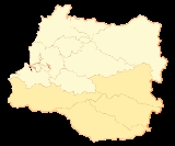
The XIV Los Ríos Region is one of Chile
's 15 first order administrative division
s. Its capital is Valdivia
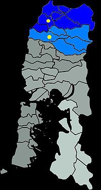
. Pop. 356,396 (2002 census). It began to operate as region on October 2, 2007. It was created by subdividing the Los Lagos Region
in southern Chile. It consists of two provinces: Valdivia
and—the newly created—Ranco
that was formerly part of Valdivia Province.
The new region was established in consideration of territorial, historical and geographic factors. The original Los Lagos Region was one of the largest, most diverse regions in the country, and the integration of the Province of Valdivia was difficult because of its background which differed from the four other provinces of the region, especially the southern provinces of Chiloé
and Palena
.
Some differences include:
and its 12 communes are distributed among 2 provinces. These are:
Valdivia is part of Northern Patagonia as its wild virgin forest embrace the Patagonian Cordillera following the river Calle Calle down to the Pacific Ocean. It is known in Patagonia the term " Bosque Valdiviano" referring to the primitive virgin forest found in the cordillera valleys of Valdivia which include dense masses of native trees. These Forest are present in some parts of Northern Patagonia
both in Chile and Argentina.
and La Unión
has together 50,000 inhabitants. This percentage of rural population is well above the national average which is of 13.4%. The population of Los Ríos has a relatively high percentage of people that self-identifies as indigenous
of 11.3% it means 40,515 persons. To compare, the national average is of 4.58%.
in 1960, Valdivia fell deeper into decline. Much of the city was destroyed and many people left the city.
In 1974 the military junta reorganized the political divisions of Chile deciding that Valdivia was no longer adequate to be a "first class administrative territory" capital. Hence, it was reclassified into a province within Los Lagos Region
and Puerto Montt
was designated capital. Valdivians greatly resented this decision because they felt they were better suited to be the capital than Puerto Montt, holding forth the following arguments:
signed a bill allowing for the creation of Los Ríos Region ("The Rivers Region"). The bill was approved by Congress on December 19, 2006; it was signed into law on March 16, 2007 and published on April 5, 2007. According to the Roman numeral designation, currently used in Chile, this region is number XIV (fourteenth). However, steps are being taken to no longer refer to the regions by numbers.
made several proposals:
It was proposed that Osorno Province
join as the third province of the new region, instead of remaining the fourth province of Los Lagos Region
, however, in a referendum held in 2006 the residents of that province rejected the idea.
 Los Ríos Regions lies in the southern temperate zone and in a tectonically active
milieu. Four distinct landscape types, or morphological units, can be distinguished in the region. These are from west to east; the Coastal Range
, a the Intermediate Depression, the Precordillera
and the Andes
. These units are oriented parallel to the coast and the subduction zone
there. An exception to this are the eastern hills in Mariquina and Máfil
that despite belonging to the Coast Range system adrift eastwards and comes very close to the Precordillera cutting the Intermediate Depression in two. The Coastal Cordillera does not exceed the 1000 m in height being Cerro Oncol
(715 m) the highest point in the section north of Valdivia River. The Coast Range is cut by Valdivia
and Bueno River
s, deeply incised rivers that drains the inland. Most the Coast is covered by native Valdivian temperate rain forest, although it has in some parts been substituted by plantations of exotic species, specially Douglas firs and eucalyptus
.
Two great agricultural flatlands exists in the region, the Mariquina valley and Los Llanos of La Unión
and Río Bueno
. The first one is a tectonic depression in the Coast Range connected to Valdivia by Cruces River
and the second is the continuation of the Intermediate Depression that re-opens south of Máfil. The flatlands and mayor river valleys form large, open, cultural landscapes used as grassing meadow
s or for growing crops.
The Precordillera is a narrow band characterized by hosting a large number of deep glacial
piedmont lakes that are dammed by moraine
s. These lakes intersects forested granitic mountain massifs of up to 1500 m. The Precordilleran hills and mountains have step slopes to the north and south as the main direction of the Quaternary glaciers
where from east to west. Many lake shores are cleared lands where agriculture, settlements and resort areas develops.
in Argentina
. The Andes in this part of Chile, the Zona Sur
, has almost escaped the Andean orogenesis. Here the Andes consist of old granitic pluton
s such as the Panguipulli Batholith
and the Northern Patagonian Batholith
together with volcanics and some minor areas of sediments and metasediment
s. As result of the minimal Andean mountainbuilding the mountains shows little rejuvenation and are mostly shaped by erosive agents, specially glaciers. An exception to this are the several volcanoes that rises east of the piedmont lakes, this volcanoes are among the most active in Chile and as result their form are influenced by the eruptions; either in constructive manner such as Villarrica Volcano
or more destructive like Quetrupillán
. The fact that these volcanoes have the ability to build up cones and rise again after erosion and explosive eruptions makes many of them the highest mountains in the region and Zona Sur
. The volcanoes of Los Ríos Regions belong to the Southern Volcanic Zone of Andes, whose current activity front is located about 200 km west from the main Andean cordillera, this makes volcanoes stand out as isolated snow-covered cones of more than 2000 m, above the lower mountains that rarely pass the 1500 m. The main cordillera makes up the continental divide
and are therefore according the 1881 Argentina-Chile treaty the border between the two nations. Faults and glacier action have however made a gap at the site of Huahum Pass
where waters from the eastern Argentine slopes drains westward to the Pacific Mountains at the cordillera may reach at most some 2000 m in height. Andean valleys of Los Ríos Region are deep and broad and either used for raising cattle or for wood lodging, as well as tourism and protection of biodiversity
. These glacial valleys are placed above old Miocene
rivers and faults. The chief fault is the Liquiñe-Ofqui Fault
that crosses the whole region from north to south allowing numerous valleys to develop above it. The Liquiñe-Ofqui Fault
is tectonically active causing minor tremors and is also believed responsible by geologists for the alignment of the volcanoes of the southern section of the Southern Volcanic Zone. Along Liquiñe-Ofqui Fault there are several hotsprings such as Liquiñe
, Chihuío
, Termas Geométricas, Termas Vergara and Termas de Coñaripe.
at the city of Valdivia
. These rivers drain most of northern Los Ríos Region as well as parts of Araucanía Region
and Neuquén Province
in Argentina
. A second large river, Bueno River
is responsible for the draining of the southern parts of the region including Ranco Lake
, Chile's 4th largest lake. Bueno River and its tributary Pilmaiquén River
also drain large areas of Osorno Province
and form the southern boundary of the region. These two big river systems receive a continuous inflow of water due to being fed by lakes and lake chains in the Andes. Valdivia River is provided by the Seven Lakes chain plus Lácar Lake
and Bueno River
from Ranco
, Maihue
and Puyehue Lake
. The large lakes in the interior are fed by rainwater and snow melt from the higher mountains. Glacier
s and semipermanent snow patches have relatively low share flow volume of the main rivers.
Chile
Chile ,officially the Republic of Chile , is a country in South America occupying a long, narrow coastal strip between the Andes mountains to the east and the Pacific Ocean to the west. It borders Peru to the north, Bolivia to the northeast, Argentina to the east, and the Drake Passage in the far...
's 15 first order administrative division
Administrative division
An administrative division, subnational entity, or country subdivision is a portion of a country or other political division, established for the purpose of government. Administrative divisions are each granted a certain degree of autonomy, and are required to manage themselves through their own...
s. Its capital is Valdivia
Valdivia, Chile
Valdivia is a city and commune in southern Chile administered by the Municipality of Valdivia. The city is named after its founder Pedro de Valdivia and is located at the confluence of the Calle-Calle, Valdivia and Cau-Cau Rivers, approximately east of the coastal towns of Corral and Niebla...
. Pop. 356,396 (2002 census). It began to operate as region on October 2, 2007. It was created by subdividing the Los Lagos Region
Los Lagos Region
Los Lagos Region is one of Chile's 15 regions, which are first order administrative divisions, and comprises four provinces: Chiloé, Llanquihue, Osorno and Palena. The region contains the country's second largest island, Chiloé, and the second largest lake, Llanquihue.Its capital is Puerto Montt;...
in southern Chile. It consists of two provinces: Valdivia
Valdivia Province
Valdivia Province is one of two provinces of the southern Chilean region of Los Ríos . The provincial capital is Valdivia. Located in the province are two important rivers, the Calle-Calle / Valdivia River and the Cruces River.It is part of Northern Patagonia and its wild virgin forest embrace the...
and—the newly created—Ranco
Ranco Province
Ranco Province is one of two provinces of the southern Chilean region of Los Ríos . It is named after Ranco Lake shared by the communes of Futrono and Lago Ranco. The lake is drained by the Bueno River, on which basin lies most of the province...
that was formerly part of Valdivia Province.
The new region was established in consideration of territorial, historical and geographic factors. The original Los Lagos Region was one of the largest, most diverse regions in the country, and the integration of the Province of Valdivia was difficult because of its background which differed from the four other provinces of the region, especially the southern provinces of Chiloé
Chiloé Province
Chiloé Province is one of the four provinces in the southern Chilean region of Los Lagos . It encompasses all of Chiloé Archipelago with the exception of the Desertores Islands. The province spans a surface area of...
and Palena
Palena Province
Palena Province is one of the four provinces in the southern Chilean region of Los Lagos . Due to the eruption of Chaitén Volcano and the subsequent destruction of Chaitén, Futaleufú is since March 2009 the new capital of Palena Province. The private Pumalín Park is located in the province as is...
.
Some differences include:
- Valdivia has a colonial past while most of the Los Lagos Region was colonized in the 19th century.
- Valdivia's economy is more oriented to forestryForestryForestry is the interdisciplinary profession embracing the science, art, and craft of creating, managing, using, and conserving forests and associated resources in a sustainable manner to meet desired goals, needs, and values for human benefit. Forestry is practiced in plantations and natural stands...
, while the other provinces are more active in fishing and cattle farming. - Valdivia, with 356,396 inhabitants, was the most populated province in the Los Lagos Region, while PalenaPalena ProvincePalena Province is one of the four provinces in the southern Chilean region of Los Lagos . Due to the eruption of Chaitén Volcano and the subsequent destruction of Chaitén, Futaleufú is since March 2009 the new capital of Palena Province. The private Pumalín Park is located in the province as is...
, in contrast, has only 18,971 residents.
Government and administration
The capital of region is ValdiviaValdivia
-Geography:*Chile** Valdivia, Chile, a city and municipality in the Province of Valdivia** Valdivia River, a river which begins in the city of Valdivia** Valdivia Province, the Province of Valdivia...
and its 12 communes are distributed among 2 provinces. These are:
- Valdivia ProvinceValdivia ProvinceValdivia Province is one of two provinces of the southern Chilean region of Los Ríos . The provincial capital is Valdivia. Located in the province are two important rivers, the Calle-Calle / Valdivia River and the Cruces River.It is part of Northern Patagonia and its wild virgin forest embrace the...
: Including Valdivia, Mariquina, Lanco, PanguipulliPanguipulli, ChilePanguipulli is city and commune in Valdivia Province, southern Chile, administered by the Municipality of Panguipulli. The town is known for its natural beauty and is called "City of roses" . Panguipulli is located on the western edge of Panguipulli Lake, and is on a moraine in the Chilean Central...
, Máfil, Los LagosLos Lagos, ChileLos Lagos is a Chilean city and commune in Valdivia Province, Los Ríos Region.-Demographics:According to the 2002 census of the National Statistics Institute, Los Lagos spans an area of and has 20,168 inhabitants . Of these, 9,479 lived in urban areas and 10,689 in rural areas...
, Paillaco, and Corral municipalities - Ranco ProvinceRanco ProvinceRanco Province is one of two provinces of the southern Chilean region of Los Ríos . It is named after Ranco Lake shared by the communes of Futrono and Lago Ranco. The lake is drained by the Bueno River, on which basin lies most of the province...
: Including La UniónLa Unión, ChileLa Unión is a city and commune of the Ranco Province in the Los Rios Region in Chile. It is situated approximately 40 km north of Osorno and 80 km south east of Valdivia. It covers an area of approximately 2136.7 km² and has a population of 39.447 of which 25,615 are considered part...
, Río BuenoRío Bueno, ChileRío Bueno is a city and commune in southern Chile administered by the Municipality of Río Bueno. It is located in Ranco Province in Los Ríos Region...
, Lago RancoLago Ranco, ChileLago Ranco is a town and commune in southern Chile administered by the Municipality of Lago Ranco. It is located in Ranco Province in Los Ríos Region...
and Futrono municipalities.
Valdivia is part of Northern Patagonia as its wild virgin forest embrace the Patagonian Cordillera following the river Calle Calle down to the Pacific Ocean. It is known in Patagonia the term " Bosque Valdiviano" referring to the primitive virgin forest found in the cordillera valleys of Valdivia which include dense masses of native trees. These Forest are present in some parts of Northern Patagonia
Patagonia
Patagonia is a region located in Argentina and Chile, integrating the southernmost section of the Andes mountains to the southwest towards the Pacific ocean and from the east of the cordillera to the valleys it follows south through Colorado River towards Carmen de Patagones in the Atlantic Ocean...
both in Chile and Argentina.
Demography
In the last census, of 2002, Los Ríos Region (then Valdivia Province) registered a population of 356,396 inhabitants. By this number the region is ranked 10th among Chile's 15 regions and has a share of 2.35% of the national total. The current population projection to 2010 is of 380,000 inhabitants. The regions rural population represents 32% of the total, which is explained by the fact that almost half of the population lives in the city of Valdivia and that the cities of Río BuenoRío Bueno, Chile
Río Bueno is a city and commune in southern Chile administered by the Municipality of Río Bueno. It is located in Ranco Province in Los Ríos Region...
and La Unión
La Unión, Chile
La Unión is a city and commune of the Ranco Province in the Los Rios Region in Chile. It is situated approximately 40 km north of Osorno and 80 km south east of Valdivia. It covers an area of approximately 2136.7 km² and has a population of 39.447 of which 25,615 are considered part...
has together 50,000 inhabitants. This percentage of rural population is well above the national average which is of 13.4%. The population of Los Ríos has a relatively high percentage of people that self-identifies as indigenous
Indigenous peoples in Chile
Indigenous peoples in Chile form about 4.6% of the total population .The Mapuches, from the south, accounted for approximately 85 percent of this number...
of 11.3% it means 40,515 persons. To compare, the national average is of 4.58%.
| Commune | Population | Density (hab/km2) | Poverty (%) | Rural population (%) | Indigenous peoples (%)In the 2002 Census indigenous peoples were calculated on the basis of selfidentification. The dominant indigenous peoples in Los Ríos Region are Huilliche Huilliche The Huilliche is an ethnic group of Chile, belonging to the Mapuche culture. They live in mountain valleys in an area south of Toltén River and on Chiloé Archipelago... and Mapuche Mapuche The Mapuche are a group of indigenous inhabitants of south-central Chile and southwestern Argentina. They constitute a wide-ranging ethnicity composed of various groups who shared a common social, religious and economic structure, as well as a common linguistic heritage. Their influence extended... , while indigenos peoples from other areas of Chile makes up a tiny minority, located mainly in Valdivia. | Illiteracy (%) |
|---|---|---|---|---|---|---|
| Corral | 5,463 | 7.1 | 37.3 | 32.8 | 11.5 | 9.9 |
| Futrono Futrono Futrono is a city and commune in southern Chile administered by the Municipality of Futrono... |
14,981 | 7.1 | 35.1 | 43.9 | 17.9 | 8.0 |
| La Unión La Unión, Chile La Unión is a city and commune of the Ranco Province in the Los Rios Region in Chile. It is situated approximately 40 km north of Osorno and 80 km south east of Valdivia. It covers an area of approximately 2136.7 km² and has a population of 39.447 of which 25,615 are considered part... |
39,447 | 18.5 | 26.5 | 35.1 | 9.2 | 6.7 |
| Lago Ranco Lago Ranco Lago Ranco is a Chilean place name that may refer to:* Ranco Lake Chile's third largest lake by surface area* Lago Ranco, Chile a city and municipality in Chile in the lakeside of Ranco Lake... |
10,098 | 5.7 | 29.6 | 78.2 | 31.8 | 9.3 |
| Lanco Lanco Lanco is a city and commune in southern Chile administered by the Municipality of Lanco. It is located in Valdivia Province in Los Ríos Region, about northeast of Valdivia close to Cruces River.-Demographics:... |
15,107 | 28.4 | 35.0 | 31.3 | 19.3 | 7.6 |
| Los Lagos Los Lagos, Chile Los Lagos is a Chilean city and commune in Valdivia Province, Los Ríos Region.-Demographics:According to the 2002 census of the National Statistics Institute, Los Lagos spans an area of and has 20,168 inhabitants . Of these, 9,479 lived in urban areas and 10,689 in rural areas... |
20,168 | 11.3 | 35.5 | 53.0 | 3.9 | 9.1 |
| Máfil Máfil Máfil is a town and commune of the Valdivia Province, Los Ríos Region in southern Chile, about 30 km northeast of Valdivia... |
7,213 | 12.4 | 21.3 | 47.4 | 6.3 | 8.9 |
| Paillaco Paillaco Paillaco is a city and commune in southern Chile. It is located in Valdivia Province in Los Ríos Region, and is about 48 km southeast of Valdivia... |
19,237 | 21.5 | 29.7 | 48.8 | 4.9 | 7.2 |
| Panguipulli Panguipulli Panguipulli is city and commune in Valdivia Province, southern Chile, administered by the Municipality of Panguipulli. The town is known for its natural beauty and is called "City of roses" . Panguipulli is located on the western edge of Panguipulli Lake, and is on a moraine in the Chilean Central... |
33,273 | 10.1 | 34.4 | 52.2 | 30.8 | 14.1 |
| Río Bueno Río Bueno, Chile Río Bueno is a city and commune in southern Chile administered by the Municipality of Río Bueno. It is located in Ranco Province in Los Ríos Region... |
32,627 | 14.8 | 36.8 | 53.9 | 11.9 | 9.7 |
| Mariquina | 18,223 | 13.8 | 29.4 | 51.0 | 23.2 | 8.5 |
| Valdivia Valdivia, Chile Valdivia is a city and commune in southern Chile administered by the Municipality of Valdivia. The city is named after its founder Pedro de Valdivia and is located at the confluence of the Calle-Calle, Valdivia and Cau-Cau Rivers, approximately east of the coastal towns of Corral and Niebla... |
140,559 | 138.4 | 20.8 | 7.5 | 5.0 | 2.3 |
Settlements
| Name | Population | Type | Commune |
|---|---|---|---|
| Antilhue Antilhue Antilhue is a village in Chile, South America. It is located in the commune of Los Lagos on the shores of Calle-Calle River just east of Valdivia. Two petroleum-fueled power plants, Antilhue I and Antilhue II, with a combined pruduction capacity of 101.3 MW, are located near the village.... |
934 | Village | Los Lagos Los Lagos, Chile Los Lagos is a Chilean city and commune in Valdivia Province, Los Ríos Region.-Demographics:According to the 2002 census of the National Statistics Institute, Los Lagos spans an area of and has 20,168 inhabitants . Of these, 9,479 lived in urban areas and 10,689 in rural areas... |
| Calafquén Calafquén Calafquén is a Chilean hamlet in Panguipulli commune, of Los Ríos Region. Located on the southern shores of Calafquén Lake, Calafquén is a popular resort area during the summer months .... |
103 | Hamlet | Panguipulli Panguipulli, Chile Panguipulli is city and commune in Valdivia Province, southern Chile, administered by the Municipality of Panguipulli. The town is known for its natural beauty and is called "City of roses" . Panguipulli is located on the western edge of Panguipulli Lake, and is on a moraine in the Chilean Central... |
| Caleta Chaihuín Caleta Chaihuín Caleta Chaihuín is a coastal hamlet in the commune of Corral, Chile. It lies at the mouth of Chaihuín River that flows from the Valdivian Coast Range to the Pacific Ocean. The administration and main entrance to the Valdivian Coastal Reserve lies in Chaihuín.... |
36 | Hamlet | Corral |
| Choshuenco Choshuenco Choshuenco is a village on the eastern edge of Panguipulli Lake in Panguipulli's commune, Chile. It lies about 4 km south of the 203-CH route that goes from Lanco to Huahum Pass into Argentina.... |
625 | Village | Panguipulli Panguipulli, Chile Panguipulli is city and commune in Valdivia Province, southern Chile, administered by the Municipality of Panguipulli. The town is known for its natural beauty and is called "City of roses" . Panguipulli is located on the western edge of Panguipulli Lake, and is on a moraine in the Chilean Central... |
| Coñaripe Coñaripe Coñaripe is a Chilean town and resort area, located on the shore of Calafquén Lake. Administratively it belongs to Panguipulli commune in Valdivia Province of Los Ríos Region.... |
1,416 | Town | Panguipulli Panguipulli, Chile Panguipulli is city and commune in Valdivia Province, southern Chile, administered by the Municipality of Panguipulli. The town is known for its natural beauty and is called "City of roses" . Panguipulli is located on the western edge of Panguipulli Lake, and is on a moraine in the Chilean Central... |
| Corral | 3,670 | Town | Corral |
| Curiñanco | 274 | Hamlet | Valdivia Valdivia, Chile Valdivia is a city and commune in southern Chile administered by the Municipality of Valdivia. The city is named after its founder Pedro de Valdivia and is located at the confluence of the Calle-Calle, Valdivia and Cau-Cau Rivers, approximately east of the coastal towns of Corral and Niebla... |
| Futrono Futrono Futrono is a city and commune in southern Chile administered by the Municipality of Futrono... |
6,603 | City | Futrono Futrono Futrono is a city and commune in southern Chile administered by the Municipality of Futrono... |
| La Unión La Unión, Chile La Unión is a city and commune of the Ranco Province in the Los Rios Region in Chile. It is situated approximately 40 km north of Osorno and 80 km south east of Valdivia. It covers an area of approximately 2136.7 km² and has a population of 39.447 of which 25,615 are considered part... |
25,615 | City | La Unión La Unión, Chile La Unión is a city and commune of the Ranco Province in the Los Rios Region in Chile. It is situated approximately 40 km north of Osorno and 80 km south east of Valdivia. It covers an area of approximately 2136.7 km² and has a population of 39.447 of which 25,615 are considered part... |
| Lanco Lanco Lanco is a city and commune in southern Chile administered by the Municipality of Lanco. It is located in Valdivia Province in Los Ríos Region, about northeast of Valdivia close to Cruces River.-Demographics:... |
7,817 | City | Lanco Lanco Lanco is a city and commune in southern Chile administered by the Municipality of Lanco. It is located in Valdivia Province in Los Ríos Region, about northeast of Valdivia close to Cruces River.-Demographics:... |
| Lago Ranco Lago Ranco, Chile Lago Ranco is a town and commune in southern Chile administered by the Municipality of Lago Ranco. It is located in Ranco Province in Los Ríos Region... |
2,205 | Town | Lago Ranco Lago Ranco, Chile Lago Ranco is a town and commune in southern Chile administered by the Municipality of Lago Ranco. It is located in Ranco Province in Los Ríos Region... |
| Liquiñe Liquiñe Liquiñe is a town in Liquiñe Valley, in Panguipulli commune, Valdivia Province, Chile. The area around the village is home to South America's densest collection of hot springs. There are literally hundred of sites where geothermal waters flow up out of the earth. The water emerges from the ground... |
1,205 | Town | Panguipulli Panguipulli, Chile Panguipulli is city and commune in Valdivia Province, southern Chile, administered by the Municipality of Panguipulli. The town is known for its natural beauty and is called "City of roses" . Panguipulli is located on the western edge of Panguipulli Lake, and is on a moraine in the Chilean Central... |
| Llifén Llifén Llifén is a town in the commune of Futrono on the shores of Ranco Lake located near the mouth of Calcurrupe River.... |
748 | Town | Futrono Futrono Futrono is a city and commune in southern Chile administered by the Municipality of Futrono... |
| Los Lagos Los Lagos, Chile Los Lagos is a Chilean city and commune in Valdivia Province, Los Ríos Region.-Demographics:According to the 2002 census of the National Statistics Institute, Los Lagos spans an area of and has 20,168 inhabitants . Of these, 9,479 lived in urban areas and 10,689 in rural areas... |
9,479 | City | Los Lagos Los Lagos, Chile Los Lagos is a Chilean city and commune in Valdivia Province, Los Ríos Region.-Demographics:According to the 2002 census of the National Statistics Institute, Los Lagos spans an area of and has 20,168 inhabitants . Of these, 9,479 lived in urban areas and 10,689 in rural areas... |
| Máfil Máfil Máfil is a town and commune of the Valdivia Province, Los Ríos Region in southern Chile, about 30 km northeast of Valdivia... |
3,793 | Town | Máfil Máfil Máfil is a town and commune of the Valdivia Province, Los Ríos Region in southern Chile, about 30 km northeast of Valdivia... |
| Malalhue Malalhue Malahue is a town in the commune of Lanco located northwest of Panguipulli, Chile. The main economic activity of the zone is the manufacturing of oriented strand boards at Louisiana-Pacific's a manufacturing plant near the town. The town lies along the 203-CH route that connects Panguipulli with... |
2,566 | Town | Lanco Lanco Lanco is a city and commune in southern Chile administered by the Municipality of Lanco. It is located in Valdivia Province in Los Ríos Region, about northeast of Valdivia close to Cruces River.-Demographics:... |
| Neltume | 2,125 | Town | Panguipulli Panguipulli, Chile Panguipulli is city and commune in Valdivia Province, southern Chile, administered by the Municipality of Panguipulli. The town is known for its natural beauty and is called "City of roses" . Panguipulli is located on the western edge of Panguipulli Lake, and is on a moraine in the Chilean Central... |
| Mehuín Mehuín Mehuín is a Chilean town and harbour, located on the shores of the Pacific Ocean at the mouth of Lingue River. Administratively it belongs to the San José de la Mariquina commune in Valdivia Province of Los Ríos Region.... |
1,135 | Town | Mariquina |
| Niebla Niebla -Places:* Niebla, Chile, a coastal town in the municipality of Valdivia* Niebla, Huelva, a municipality in Huelva province, Spain* Taifa of Niebla, a medieval taifa kingdom of the Iberian peninsula-People:* Mr... |
2,202 | Town | Valdivia Valdivia, Chile Valdivia is a city and commune in southern Chile administered by the Municipality of Valdivia. The city is named after its founder Pedro de Valdivia and is located at the confluence of the Calle-Calle, Valdivia and Cau-Cau Rivers, approximately east of the coastal towns of Corral and Niebla... |
| Nontuela | 1,048 | Town | Futrono Futrono Futrono is a city and commune in southern Chile administered by the Municipality of Futrono... |
| Riñihue Riñihue, Chile Riñihue is a hamlet in Los Lagos, Chile. It is located south of the Tralcán Mount in the west side of Riñihue Lake. In early 20th century Riñihue grew out as a settlement due to the exploitation of wood in Riñihue Lake. Riñihue was the first Chilean lakeshore settlement to be reached by the... |
243 | Hamlet | Los Lagos Los Lagos, Chile Los Lagos is a Chilean city and commune in Valdivia Province, Los Ríos Region.-Demographics:According to the 2002 census of the National Statistics Institute, Los Lagos spans an area of and has 20,168 inhabitants . Of these, 9,479 lived in urban areas and 10,689 in rural areas... |
| Río Bueno Río Bueno, Chile Río Bueno is a city and commune in southern Chile administered by the Municipality of Río Bueno. It is located in Ranco Province in Los Ríos Region... |
15,054 | City | Río Bueno Río Bueno, Chile Río Bueno is a city and commune in southern Chile administered by the Municipality of Río Bueno. It is located in Ranco Province in Los Ríos Region... |
| Panguipulli Panguipulli, Chile Panguipulli is city and commune in Valdivia Province, southern Chile, administered by the Municipality of Panguipulli. The town is known for its natural beauty and is called "City of roses" . Panguipulli is located on the western edge of Panguipulli Lake, and is on a moraine in the Chilean Central... |
11,142 | City | Panguipulli Panguipulli, Chile Panguipulli is city and commune in Valdivia Province, southern Chile, administered by the Municipality of Panguipulli. The town is known for its natural beauty and is called "City of roses" . Panguipulli is located on the western edge of Panguipulli Lake, and is on a moraine in the Chilean Central... |
| Paillaco Paillaco Paillaco is a city and commune in southern Chile. It is located in Valdivia Province in Los Ríos Region, and is about 48 km southeast of Valdivia... |
9,973 | City | Paillaco Paillaco Paillaco is a city and commune in southern Chile. It is located in Valdivia Province in Los Ríos Region, and is about 48 km southeast of Valdivia... |
| Puerto Fuy Puerto Fuy Puerto Fuy is a Chilean village in Panguipulli commune, of Los Ríos Region. Puerto Fuy lies along the 203-CH route to Huahum Pass into Argentina at western edge of Pirihueico Lake and is a terminal station of the ferry that corsses the lake connecting to Puerto Pirihueico.... |
391 | Village | Panguipulli Panguipulli, Chile Panguipulli is city and commune in Valdivia Province, southern Chile, administered by the Municipality of Panguipulli. The town is known for its natural beauty and is called "City of roses" . Panguipulli is located on the western edge of Panguipulli Lake, and is on a moraine in the Chilean Central... |
| Puerto Pirihueico Puerto Pirihueico Puerto Pirihueico or Pirehueico is a Chilean village in Panguipulli commune, of Los Ríos Region. Puerto Pirehueico lies along the 203-CH route to Huahum Pass into Argentina at eastern edge of Pirihueico Lake and is a terminal station of the ferry that corsses the lake connecting to Puerto... |
13 | Village | Panguipulli Panguipulli, Chile Panguipulli is city and commune in Valdivia Province, southern Chile, administered by the Municipality of Panguipulli. The town is known for its natural beauty and is called "City of roses" . Panguipulli is located on the western edge of Panguipulli Lake, and is on a moraine in the Chilean Central... |
| San José de la Mariquina | 7,790 | City | Mariquina |
| Pishuinco Pishuinco Pishuinco is a hamlet in the commune of Valdivia, Chile. It lies at the northern end of the Calle-Calle River between the city of Valdivia and Antilhue.... |
228 | Hamlet | Valdivia Valdivia, Chile Valdivia is a city and commune in southern Chile administered by the Municipality of Valdivia. The city is named after its founder Pedro de Valdivia and is located at the confluence of the Calle-Calle, Valdivia and Cau-Cau Rivers, approximately east of the coastal towns of Corral and Niebla... |
| Punucapa Punucapa Punucapa is a hamlet of pre-Hispanic origin in Los Ríos Region, Chile. Its isolated location by the Cruces River and the Valdivian Coastal Range has make the village an ecotourism attraction. The wetlands of the river is the home to thousands of birds; the Black-necked Swan is the most emblematic... |
75 | Hamlet | Valdivia Valdivia, Chile Valdivia is a city and commune in southern Chile administered by the Municipality of Valdivia. The city is named after its founder Pedro de Valdivia and is located at the confluence of the Calle-Calle, Valdivia and Cau-Cau Rivers, approximately east of the coastal towns of Corral and Niebla... |
| Torobayo Torobayo Torobayo is a suburb of Valdivia, Chile. It lies west of Isla Teja and connects to the city through Río Cruces Bridge. The Kunstmann beer factory and restaurant list within Torobayo and produces an ale beer named Torobayo Ale.... |
148 | Hamlet | Valdivia Valdivia, Chile Valdivia is a city and commune in southern Chile administered by the Municipality of Valdivia. The city is named after its founder Pedro de Valdivia and is located at the confluence of the Calle-Calle, Valdivia and Cau-Cau Rivers, approximately east of the coastal towns of Corral and Niebla... |
| Valdivia Valdivia, Chile Valdivia is a city and commune in southern Chile administered by the Municipality of Valdivia. The city is named after its founder Pedro de Valdivia and is located at the confluence of the Calle-Calle, Valdivia and Cau-Cau Rivers, approximately east of the coastal towns of Corral and Niebla... |
127,750 | City | Valdivia Valdivia, Chile Valdivia is a city and commune in southern Chile administered by the Municipality of Valdivia. The city is named after its founder Pedro de Valdivia and is located at the confluence of the Calle-Calle, Valdivia and Cau-Cau Rivers, approximately east of the coastal towns of Corral and Niebla... |
History
Republic of Chile
In the beginning of the Chilean Republic, Valdivia was one of the original eight provinces established. The reason for the incorporation was not so much the value of Valdivia, per se, but to minimize the threat to Chilean independence posed by Spaniards in the territory. As German Chilean immigrants arrived in the city during the mid 19th century, the local economy started to develop industries. By 1900, Valdivia was the third most industrialized city in Chile, however, a period of decline started with the world wars. After the Great Chilean EarthquakeGreat Chilean Earthquake
The 1960 Valdivia earthquake or Great Chilean Earthquake of Sunday, 22 May 1960 is to date the most powerful earthquake ever recorded on Earth, rating 9.5 on the moment magnitude scale...
in 1960, Valdivia fell deeper into decline. Much of the city was destroyed and many people left the city.
In 1974 the military junta reorganized the political divisions of Chile deciding that Valdivia was no longer adequate to be a "first class administrative territory" capital. Hence, it was reclassified into a province within Los Lagos Region
Los Lagos Region
Los Lagos Region is one of Chile's 15 regions, which are first order administrative divisions, and comprises four provinces: Chiloé, Llanquihue, Osorno and Palena. The region contains the country's second largest island, Chiloé, and the second largest lake, Llanquihue.Its capital is Puerto Montt;...
and Puerto Montt
Puerto Montt
Puerto Montt is a port city and commune in southern Chile, located at the northern end of the Reloncaví Sound in the Llanquihue Province, Los Lagos Region. The commune spans an area of and had a population of 175,938 in 2002. It is located 1,055 km to the south of the capital, Santiago...
was designated capital. Valdivians greatly resented this decision because they felt they were better suited to be the capital than Puerto Montt, holding forth the following arguments:
- Valdivia was founded in 1552,
- Valdivia had resisted pirate attacks and hostile nativesArauco WarThe Arauco War was a conflict between colonial Spaniards and the Mapuche people in what is now the Araucanía and Biobío regions of modern Chile...
, - Valdivia had survived several earthquakes,
- Puerto Montt, founded in 1853, three hundred and one years later, was a considerably newer city.
Creation of the new region
On October 19, 2005 Chilean President Ricardo LagosRicardo Lagos
Ricardo Froilán Lagos Escobar is a lawyer, economist and social democrat politician, who served as president of Chile from 2000 to 2006. He won the 1999-2000 presidential election by a narrow margin in a runoff over Independent Democrat Union candidate Joaquín Lavín...
signed a bill allowing for the creation of Los Ríos Region ("The Rivers Region"). The bill was approved by Congress on December 19, 2006; it was signed into law on March 16, 2007 and published on April 5, 2007. According to the Roman numeral designation, currently used in Chile, this region is number XIV (fourteenth). However, steps are being taken to no longer refer to the regions by numbers.
Osorno
When the new region was considered by Congress, OsornoOsorno, Chile
Osorno is a city and commune in southern Chile and capital of Osorno Province in the Los Lagos Region. It had a population of 145,475, as of the 2002 census...
made several proposals:
- To make Osorno the new capital
- To make La UniónLa Unión, ChileLa Unión is a city and commune of the Ranco Province in the Los Rios Region in Chile. It is situated approximately 40 km north of Osorno and 80 km south east of Valdivia. It covers an area of approximately 2136.7 km² and has a population of 39.447 of which 25,615 are considered part...
the capital - To expand Osorno Province adding to it the comuna of Río BuenoRío Bueno, ChileRío Bueno is a city and commune in southern Chile administered by the Municipality of Río Bueno. It is located in Ranco Province in Los Ríos Region...
.
It was proposed that Osorno Province
Osorno Province
Osorno Province is one of the four provinces in the southern Chilean region of Los Lagos . The province has an area of and a population of 221,509 distributed across seven communes . The provincial capital is the city of Osorno....
join as the third province of the new region, instead of remaining the fourth province of Los Lagos Region
Los Lagos Region
Los Lagos Region is one of Chile's 15 regions, which are first order administrative divisions, and comprises four provinces: Chiloé, Llanquihue, Osorno and Palena. The region contains the country's second largest island, Chiloé, and the second largest lake, Llanquihue.Its capital is Puerto Montt;...
, however, in a referendum held in 2006 the residents of that province rejected the idea.
Geography
Plate tectonics
Plate tectonics is a scientific theory that describes the large scale motions of Earth's lithosphere...
milieu. Four distinct landscape types, or morphological units, can be distinguished in the region. These are from west to east; the Coastal Range
Chilean Coast Range
The Chilean Coastal Range is a mountain range that runs from north to south along the Pacific coast of South America parallel to the Andean Mountains, extending from Morro de Arica in the north to Taitao Peninsula, where it ends at the Chile Triple Junction, in the south. The range has a strong...
, a the Intermediate Depression, the Precordillera
Precordillera
Precordillera is a Spanish geographical term for hills and mountains lying before a greater range. The term is derived from cordillera meaning mountain range and applied usually to the Andes.Some places usually called Precordillera are:...
and the Andes
Andes
The Andes is the world's longest continental mountain range. It is a continual range of highlands along the western coast of South America. This range is about long, about to wide , and of an average height of about .Along its length, the Andes is split into several ranges, which are separated...
. These units are oriented parallel to the coast and the subduction zone
Peru-Chile Trench
The Peru-Chile Trench, also known as the Atacama Trench, is an oceanic trench in the eastern Pacific Ocean, about 160 kilometres off the coast of Peru and Chile...
there. An exception to this are the eastern hills in Mariquina and Máfil
Máfil
Máfil is a town and commune of the Valdivia Province, Los Ríos Region in southern Chile, about 30 km northeast of Valdivia...
that despite belonging to the Coast Range system adrift eastwards and comes very close to the Precordillera cutting the Intermediate Depression in two. The Coastal Cordillera does not exceed the 1000 m in height being Cerro Oncol
Cerro Oncol
Cerro Oncol is mountain located in the north of the Valdivian Coast Range, Chile. With its 715 m it is the highest peak of the Chilean Coast Range between Nahuelbuta Range and Corral Bay. Cerro Oncol and its surroundings are located inside Oncol Park....
(715 m) the highest point in the section north of Valdivia River. The Coast Range is cut by Valdivia
Valdivia River
The Valdivia River or Río Valdivia, as it is known locally, is a major river in southern Chile. It is the continuation of the Calle-Calle River, from the point where it meets the Cau-Cau River in the city of Valdivia. The Valdivia river ends in Corral Bay, on the Pacific coast. Other tributaries...
and Bueno River
Bueno River
Bueno River is a river in southern Chile. It originates in Ranco Lake and like most of Chile rivers it drains into the Pacific Ocean at the southern boundary of the Valdivian Coastal Reserve. Its lower flow forms the border between Osorno Province and Ranco Province...
s, deeply incised rivers that drains the inland. Most the Coast is covered by native Valdivian temperate rain forest, although it has in some parts been substituted by plantations of exotic species, specially Douglas firs and eucalyptus
Eucalyptus
Eucalyptus is a diverse genus of flowering trees in the myrtle family, Myrtaceae. Members of the genus dominate the tree flora of Australia...
.
Two great agricultural flatlands exists in the region, the Mariquina valley and Los Llanos of La Unión
La Unión, Chile
La Unión is a city and commune of the Ranco Province in the Los Rios Region in Chile. It is situated approximately 40 km north of Osorno and 80 km south east of Valdivia. It covers an area of approximately 2136.7 km² and has a population of 39.447 of which 25,615 are considered part...
and Río Bueno
Río Bueno, Chile
Río Bueno is a city and commune in southern Chile administered by the Municipality of Río Bueno. It is located in Ranco Province in Los Ríos Region...
. The first one is a tectonic depression in the Coast Range connected to Valdivia by Cruces River
Cruces River
The Cruces River is a river near Valdivia, Chile. Río Cruces originates from hills near the Villarica volcano and flows then in south-west direction. The southern and final part of the river follows the Valdivian Coastal Range. At the latitude of Valdivia it is crossed by Río Cruces Bridge near...
and the second is the continuation of the Intermediate Depression that re-opens south of Máfil. The flatlands and mayor river valleys form large, open, cultural landscapes used as grassing meadow
Meadow
A meadow is a field vegetated primarily by grass and other non-woody plants . The term is from Old English mædwe. In agriculture a meadow is grassland which is not grazed by domestic livestock but rather allowed to grow unchecked in order to make hay...
s or for growing crops.
The Precordillera is a narrow band characterized by hosting a large number of deep glacial
Glacial lake
A glacial lake is a lake with origins in a melted glacier. Near the end of the last glacial period, roughly 10,000 years ago, glaciers began to retreat. A retreating glacier often left behind large deposits of ice in hollows between drumlins or hills. As the ice age ended, these melted to create...
piedmont lakes that are dammed by moraine
Moraine
A moraine is any glacially formed accumulation of unconsolidated glacial debris which can occur in currently glaciated and formerly glaciated regions, such as those areas acted upon by a past glacial maximum. This debris may have been plucked off a valley floor as a glacier advanced or it may have...
s. These lakes intersects forested granitic mountain massifs of up to 1500 m. The Precordilleran hills and mountains have step slopes to the north and south as the main direction of the Quaternary glaciers
Quaternary glaciation
Quaternary glaciation, also known as the Pleistocene glaciation, the current ice age or simply the ice age, refers to the period of the last few million years in which permanent ice sheets were established in Antarctica and perhaps Greenland, and fluctuating ice sheets have occurred elsewhere...
where from east to west. Many lake shores are cleared lands where agriculture, settlements and resort areas develops.
Andes
The proper Andes extends from the eastern half of the Precordillean lakes to the border with Neuquén ProvinceNeuquén Province
Neuquén is a province of Argentina, located in the west of the country, at the northern end of Patagonia. It borders Mendoza Province to the north, Rio Negro Province to the southeast, and Chile to the west...
in Argentina
Argentina
Argentina , officially the Argentine Republic , is the second largest country in South America by land area, after Brazil. It is constituted as a federation of 23 provinces and an autonomous city, Buenos Aires...
. The Andes in this part of Chile, the Zona Sur
Zona Sur
The Zona Sur is one of the five natural regions on which CORFO divided continental Chile in 1950. Its northern border is formed by the Bío-Bío River, the limit with the Central Chile Zone. By west with the Pacific Ocean, by the east with the Andean mountains and Argentina. Its southern border is...
, has almost escaped the Andean orogenesis. Here the Andes consist of old granitic pluton
Pluton
A pluton in geology is a body of intrusive igneous rock that crystallized from magma slowly cooling below the surface of the Earth. Plutons include batholiths, dikes, sills, laccoliths, lopoliths, and other igneous bodies...
s such as the Panguipulli Batholith
Panguipulli Batholith
The Panguipulli Batholith is a granitic batholith of Jurassic age located in the Andes around Panguipulli Lake in southern Chile....
and the Northern Patagonian Batholith
Patagonian batholith
The Patagonian batholith is a series of igneous plutons in the Patagonian Andes. The batholith extendes from Navarino Island at 55 °S to the Lonquimay area at 39 °N. It is made of granite, granodiorite and tonalite...
together with volcanics and some minor areas of sediments and metasediment
Metasediment
In geology, metasediment is sediment or sedimentary rock that shows evidence of having been subjected to metamorphism. The overall composition of a metasediment can be used to identify the original sedimentary rock, even where they have been subject to high-grade metamorphism and intense...
s. As result of the minimal Andean mountainbuilding the mountains shows little rejuvenation and are mostly shaped by erosive agents, specially glaciers. An exception to this are the several volcanoes that rises east of the piedmont lakes, this volcanoes are among the most active in Chile and as result their form are influenced by the eruptions; either in constructive manner such as Villarrica Volcano
Villarrica (volcano)
Villarrica is one of Chile's most active volcanoes, rising above the lake and town of the same name. The volcano is also known as Rucapillán, a Mapuche word meaning "House of the Pillán". It is the westernmost of three large stratovolcanoes that trend perpendicular to the Andean chain along the...
or more destructive like Quetrupillán
Quetrupillán
Quetrupillán Volcano is a stratovolcano located in the Araucanía Region of Chile. It is situated between Villarrica and Lanín volcanoes, within Villarrica National Park. Geologically, Quetrupillán is located in a tectonic basement block between the main traces of Liquiñe-Ofqui Fault and...
. The fact that these volcanoes have the ability to build up cones and rise again after erosion and explosive eruptions makes many of them the highest mountains in the region and Zona Sur
Zona Sur
The Zona Sur is one of the five natural regions on which CORFO divided continental Chile in 1950. Its northern border is formed by the Bío-Bío River, the limit with the Central Chile Zone. By west with the Pacific Ocean, by the east with the Andean mountains and Argentina. Its southern border is...
. The volcanoes of Los Ríos Regions belong to the Southern Volcanic Zone of Andes, whose current activity front is located about 200 km west from the main Andean cordillera, this makes volcanoes stand out as isolated snow-covered cones of more than 2000 m, above the lower mountains that rarely pass the 1500 m. The main cordillera makes up the continental divide
Continental divide
A continental divide is a drainage divide on a continent such that the drainage basin on one side of the divide feeds into one ocean or sea, and the basin on the other side either feeds into a different ocean or sea, or else is endorheic, not connected to the open sea...
and are therefore according the 1881 Argentina-Chile treaty the border between the two nations. Faults and glacier action have however made a gap at the site of Huahum Pass
Huahum Pass
Huahum Pass is an international mountain pass in the Andes between Chile and Argentina. The pass takes its name from the Huahum River that flows from Argentina into Chile at the site of the border crossing. Even though the pass does not go through the continental divide, it crosses the highest...
where waters from the eastern Argentine slopes drains westward to the Pacific Mountains at the cordillera may reach at most some 2000 m in height. Andean valleys of Los Ríos Region are deep and broad and either used for raising cattle or for wood lodging, as well as tourism and protection of biodiversity
Biodiversity
Biodiversity is the degree of variation of life forms within a given ecosystem, biome, or an entire planet. Biodiversity is a measure of the health of ecosystems. Biodiversity is in part a function of climate. In terrestrial habitats, tropical regions are typically rich whereas polar regions...
. These glacial valleys are placed above old Miocene
Miocene
The Miocene is a geological epoch of the Neogene Period and extends from about . The Miocene was named by Sir Charles Lyell. Its name comes from the Greek words and and means "less recent" because it has 18% fewer modern sea invertebrates than the Pliocene. The Miocene follows the Oligocene...
rivers and faults. The chief fault is the Liquiñe-Ofqui Fault
Liquiñe-Ofqui Fault
The Liquiñe-Ofqui Fault is major geological fault that runs a length of roughly 1000 km in a north-south direction and exhibits current seismicity . It is located in the Chilean northern patagonean Andes. It is a dextral intra-arc transform fault...
that crosses the whole region from north to south allowing numerous valleys to develop above it. The Liquiñe-Ofqui Fault
Liquiñe-Ofqui Fault
The Liquiñe-Ofqui Fault is major geological fault that runs a length of roughly 1000 km in a north-south direction and exhibits current seismicity . It is located in the Chilean northern patagonean Andes. It is a dextral intra-arc transform fault...
is tectonically active causing minor tremors and is also believed responsible by geologists for the alignment of the volcanoes of the southern section of the Southern Volcanic Zone. Along Liquiñe-Ofqui Fault there are several hotsprings such as Liquiñe
Liquiñe
Liquiñe is a town in Liquiñe Valley, in Panguipulli commune, Valdivia Province, Chile. The area around the village is home to South America's densest collection of hot springs. There are literally hundred of sites where geothermal waters flow up out of the earth. The water emerges from the ground...
, Chihuío
Chihuío
Chihuío is a hot spring and hamlet along Curringue River in the Andes of Futrono commune, southern Chile.- Massacre of prisoners :On October 1973, about one month after the 1973 Chilean coup d'etat, the Chilean Army gathered the prisoners of the police stations of Futrono, Llifén and Chabranco and...
, Termas Geométricas, Termas Vergara and Termas de Coñaripe.
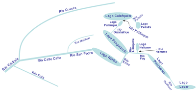
Hydrography
The region ought its name to the river network that converge in Valdivia RiverValdivia River
The Valdivia River or Río Valdivia, as it is known locally, is a major river in southern Chile. It is the continuation of the Calle-Calle River, from the point where it meets the Cau-Cau River in the city of Valdivia. The Valdivia river ends in Corral Bay, on the Pacific coast. Other tributaries...
at the city of Valdivia
Valdivia, Chile
Valdivia is a city and commune in southern Chile administered by the Municipality of Valdivia. The city is named after its founder Pedro de Valdivia and is located at the confluence of the Calle-Calle, Valdivia and Cau-Cau Rivers, approximately east of the coastal towns of Corral and Niebla...
. These rivers drain most of northern Los Ríos Region as well as parts of Araucanía Region
Araucanía Region
The IX Araucanía Region is one of Chile's 15 first order administrative divisions and comprises two provinces: Malleco in the north and Cautín in the south....
and Neuquén Province
Neuquén Province
Neuquén is a province of Argentina, located in the west of the country, at the northern end of Patagonia. It borders Mendoza Province to the north, Rio Negro Province to the southeast, and Chile to the west...
in Argentina
Argentina
Argentina , officially the Argentine Republic , is the second largest country in South America by land area, after Brazil. It is constituted as a federation of 23 provinces and an autonomous city, Buenos Aires...
. A second large river, Bueno River
Bueno River
Bueno River is a river in southern Chile. It originates in Ranco Lake and like most of Chile rivers it drains into the Pacific Ocean at the southern boundary of the Valdivian Coastal Reserve. Its lower flow forms the border between Osorno Province and Ranco Province...
is responsible for the draining of the southern parts of the region including Ranco Lake
Ranco Lake
Ranco Lake is located in Ranco Province of Chile. It is the largest lake of Los Ríos Region and the fourth largest in Chile. Administratively Ranco Lake is split into three communes; La Unión, Futrono and Lago Ranco. The lake host a series of islands of which Guapi Island is the largest. The...
, Chile's 4th largest lake. Bueno River and its tributary Pilmaiquén River
Pilmaiquén River
Pilmaiquén River is a river of Chile that mades up part of the border between Los Lagos Region and Los Ríos Region. Its source is Puyehue Lake and flows northwesterly for about 68 km until discharging into Bueno River....
also drain large areas of Osorno Province
Osorno Province
Osorno Province is one of the four provinces in the southern Chilean region of Los Lagos . The province has an area of and a population of 221,509 distributed across seven communes . The provincial capital is the city of Osorno....
and form the southern boundary of the region. These two big river systems receive a continuous inflow of water due to being fed by lakes and lake chains in the Andes. Valdivia River is provided by the Seven Lakes chain plus Lácar Lake
Lácar Lake
The Lácar Lake is a lake of glacial origin in the . It is enclosed in a mountain range of the Andes, at 630 m above mean sea level, approximately at . The area around the lake is mostly uninhabited, except for the small city of San Martín de los Andes on its northeastern coast.The lake has a...
and Bueno River
Bueno River
Bueno River is a river in southern Chile. It originates in Ranco Lake and like most of Chile rivers it drains into the Pacific Ocean at the southern boundary of the Valdivian Coastal Reserve. Its lower flow forms the border between Osorno Province and Ranco Province...
from Ranco
Ranco Lake
Ranco Lake is located in Ranco Province of Chile. It is the largest lake of Los Ríos Region and the fourth largest in Chile. Administratively Ranco Lake is split into three communes; La Unión, Futrono and Lago Ranco. The lake host a series of islands of which Guapi Island is the largest. The...
, Maihue
Maihue Lake
The Maihue Lake is a lake located east of Ranco Lake in the Andean mountains of southern Chile. The lake is of glacial origin and it is enclosed by mountain ranges of the Andes, by all sides, and drains west to Ranco Lake....
and Puyehue Lake
Puyehue Lake
Puyehue Lake is an Andean piedmont lake located in the border of Los Lagos Region with Los Ríos Region of Chile...
. The large lakes in the interior are fed by rainwater and snow melt from the higher mountains. Glacier
Glacier
A glacier is a large persistent body of ice that forms where the accumulation of snow exceeds its ablation over many years, often centuries. At least 0.1 km² in area and 50 m thick, but often much larger, a glacier slowly deforms and flows due to stresses induced by its weight...
s and semipermanent snow patches have relatively low share flow volume of the main rivers.
See also
- List of Chile-related topics
- WikiLosRiosWikiLosRiosWikiLosRios is an Spanish-language wiki-based Web encyclopedia project about Los Ríos Region in Chile. The scope of WikiLosRios is limited to subjects related to Los Ríos Region. WikiLosRios has organized twice an article contest among secondary school students called "Construyendo Región"...
, a wiki-based web encyclopedia about Los Ríos - Flag of Los Ríos RegionFlag of Los Ríos RegionThe Flag of Los Ríos Region is one of the regional symbols of the Chilean Los Ríos Region.This emblem was officially adopted by the Regional Government on December 22, 2008, and was officially launched on August 7, 2009...
External links
- Ley Nº 20.174 (Law creating the region)