

Volleyball interchange
Encyclopedia
Highway
A highway is any public road. In American English, the term is common and almost always designates major roads. In British English, the term designates any road open to the public. Any interconnected set of highways can be variously referred to as a "highway system", a "highway network", or a...
interchange
Interchange (road)
In the field of road transport, an interchange is a road junction that typically uses grade separation, and one or more ramps, to permit traffic on at least one highway to pass through the junction without directly crossing any other traffic stream. It differs from a standard intersection, at which...
where through traffic on both main roads is grade-separated
Grade separation
Grade separation is the method of aligning a junction of two or more transport axes at different heights so that they will not disrupt the traffic flow on other transit routes when they cross each other. The composition of such transport axes does not have to be uniform; it can consist of a...
from intersections which handle transferring traffic. It is similar in design to a three-level stacked roundabout except for its use of (usually signalled) conventional intersections
Intersection (road)
An intersection is a road junction where two or more roads either meet or cross at grade . An intersection may be 3-way - a T junction or fork, 4-way - a crossroads, or 5-way or more...
, and can be thought of as two diamond interchange
Diamond interchange
A diamond interchange is a common type of road junction, used where a freeway crosses a minor road. The freeway itself is grade-separated from the minor road, one crossing the other over a bridge...
s fused together.
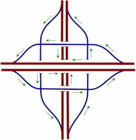
Description
In a three-level diamond interchange, the two main roads are on separate levels, and on a third level, usually in the middle, there is a square of one-way roads. The square circulates clockwise where traffic drives on the left, or anticlockwise where it drives on the right. At each corner of the square is the terminal of an exit ramp from one main road and an entrance ramp to the other main road. Traffic transferring from one road to the other to make an overall right turn only passes through one corner of the square, at which point a right turn is made. Transfer traffic making an overall left turn must proceed straight through the first intersection it encounters, turn left at the next, and then proceed straight through a third intersection to enter the other main roadway.Examples
Three-level diamond interchanges are most common in urban settings where the right-of-wayEasement
An easement is a certain right to use the real property of another without possessing it.Easements are helpful for providing pathways across two or more pieces of property or allowing an individual to fish in a privately owned pond...
for a new interchange must be kept to a minimum.
| Location | First Route | Second Route | Notes |
|---|---|---|---|
| Cedar Rapids Cedar Rapids, Iowa Cedar Rapids is the second largest city in Iowa and is the county seat of Linn County. The city lies on both banks of the Cedar River, north of Iowa City and east of Des Moines, the state's capital and largest city... , Iowa Iowa Iowa is a state located in the Midwestern United States, an area often referred to as the "American Heartland". It derives its name from the Ioway people, one of the many American Indian tribes that occupied the state at the time of European exploration. Iowa was a part of the French colony of New... |
 I-380 I-380Interstate 380 (Iowa) Interstate 380 is a auxiliary Interstate Highway located in eastern Iowa. The route extends from Interstate 80 near Coralville to Waterloo. I-380 connects the cities of Cedar Rapids and Waterloo, the second- and fifth-largest cities in the state, respectively, to the Interstate Highway System. ... |
 IA 100 IA 100 |
Collector/distributor roads intersect. |
| Sioux City Sioux City, Iowa Sioux City is a city in Plymouth and Woodbury counties in the western part of the U.S. state of Iowa. The population was 82,684 in the 2010 census, a decline from 85,013 in the 2000 census, which makes it currently the fourth largest city in the state.... , Iowa Iowa Iowa is a state located in the Midwestern United States, an area often referred to as the "American Heartland". It derives its name from the Ioway people, one of the many American Indian tribes that occupied the state at the time of European exploration. Iowa was a part of the French colony of New... |
 I-29 I-29 |
 US 77 US 77 |
|
| Detroit Detroit, Michigan Detroit is the major city among the primary cultural, financial, and transportation centers in the Metro Detroit area, a region of 5.2 million people. As the seat of Wayne County, the city of Detroit is the largest city in the U.S. state of Michigan and serves as a major port on the Detroit River... , Michigan Michigan Michigan is a U.S. state located in the Great Lakes Region of the United States of America. The name Michigan is the French form of the Ojibwa word mishigamaa, meaning "large water" or "large lake".... |
 I-75 I-75Interstate 75 Interstate 75 is a major north–south Interstate Highway in the Great Lakes and Southeastern regions of the United States. It travels from State Road 826 and State Road 924 in Hialeah, Florida to Sault Ste. Marie, Michigan, at the Ontario, Canada, border... (Walter P. Chrysler Freeway) |
 M-102 M-102M-102 (Michigan highway) M-102 is a state trunkline in the US state of Michigan, running along the northern boundary of Detroit. It is known as 8 Mile Road for most of its length. As part of the land surveying of the state, the road follows the Michigan Baseline, and it is called Base Line Road in places. M-102 is the... (8-Mile Road) |
I-75 uses frontage roads. |
| Detroit Detroit, Michigan Detroit is the major city among the primary cultural, financial, and transportation centers in the Metro Detroit area, a region of 5.2 million people. As the seat of Wayne County, the city of Detroit is the largest city in the U.S. state of Michigan and serves as a major port on the Detroit River... , Michigan Michigan Michigan is a U.S. state located in the Great Lakes Region of the United States of America. The name Michigan is the French form of the Ojibwa word mishigamaa, meaning "large water" or "large lake".... |
M-102 M-102 (Michigan highway) M-102 is a state trunkline in the US state of Michigan, running along the northern boundary of Detroit. It is known as 8 Mile Road for most of its length. As part of the land surveying of the state, the road follows the Michigan Baseline, and it is called Base Line Road in places. M-102 is the... (8-Mile Road) |
 M-1 M-1M-1 (Michigan highway) M-1, commonly known as Woodward Avenue, named for Augustus B. Woodward, is a north–south state trunkline in the US state of Michigan. Until a few years ago, the northern terminus of M-1 was at BL I-75 and BUS US 24 in Bloomfield Township between the city limits of Bloomfield Hills and... (Woodward Avenue) |
|
| Detroit Detroit, Michigan Detroit is the major city among the primary cultural, financial, and transportation centers in the Metro Detroit area, a region of 5.2 million people. As the seat of Wayne County, the city of Detroit is the largest city in the U.S. state of Michigan and serves as a major port on the Detroit River... , Michigan Michigan Michigan is a U.S. state located in the Great Lakes Region of the United States of America. The name Michigan is the French form of the Ojibwa word mishigamaa, meaning "large water" or "large lake".... |
M-102 M-102 (Michigan highway) M-102 is a state trunkline in the US state of Michigan, running along the northern boundary of Detroit. It is known as 8 Mile Road for most of its length. As part of the land surveying of the state, the road follows the Michigan Baseline, and it is called Base Line Road in places. M-102 is the... (8-Mile Road) |
 M-10 M-10M-10 (Michigan highway) M-10, is a state trunkline route in the US state of Michigan. The southernmost portion follows Jefferson Avenue in downtown Detroit, and the southern terminus is at the intersection of Jefferson and Randolph Street leading to the entrance to the Detroit–Windsor Tunnel... (John C. Lodge Freeway) |
Includes flyovers from northbound M-10 to westbound M-102, eastbound M-102 to southbound M-10, and westbound M-102 to northbound M-10. M-10 uses frontage roads. |
| Redford Township, Michigan Michigan Michigan is a U.S. state located in the Great Lakes Region of the United States of America. The name Michigan is the French form of the Ojibwa word mishigamaa, meaning "large water" or "large lake".... |
 I-96 I-96Interstate 96 Interstate 96 is an intrastate Interstate Highway that is entirely within the US state of Michigan. Its western terminus is at an interchange with US Highway 31 and Business US Highway 31 , on the western boundary of Norton Shores southeast of Muskegon. Its eastern terminus is at I-75 near the... |
 US 24 US 24U.S. Route 24 U.S. Route 24 is one of the original United States highways of 1926. It originally ran from Pontiac, Michigan, in the east to Kansas City, Missouri, in the west. Today, the highway's eastern terminus is west of Clarkston, Michigan, at an intersection with I-75 and its western terminus is near... (Telegraph Road) |
|
| Jefferson City Jefferson City, Missouri Jefferson City is the capital of the U.S. state of Missouri and the county seat of Cole County. Located in Callaway and Cole counties, it is the principal city of the Jefferson City metropolitan area, which encompasses the entirety of both counties. As of the 2010 census, the population was 43,079... , Missouri Missouri Missouri is a US state located in the Midwestern United States, bordered by Iowa, Illinois, Kentucky, Tennessee, Arkansas, Oklahoma, Kansas and Nebraska. With a 2010 population of 5,988,927, Missouri is the 18th most populous state in the nation and the fifth most populous in the Midwest. It... |
  US 50 US 50U.S. Route 50 U.S. Route 50 is a major east–west route of the U.S. Highway system, stretching just over from Ocean City, Maryland on the Atlantic Ocean to West Sacramento, California. Until 1972, when it was replaced by Interstate Highways west of the Sacramento area, it extended to San Francisco, near... /US 63 U.S. Route 63 U.S. Route 63 is a long north–south United States highway primarily in the Midwestern United States. The southern terminus of the route is at Interstate 20 in Ruston, Louisiana. The northern terminus is at U.S. Route 2 in Benoit, Wisconsin, about east of Duluth, Minnesota. It is not related to U.S... northbound |
 US 54 US 54U.S. Route 54 U.S. Route 54 is an east–west United States highway that runs northeast-southwest for 1,197 miles from western Illinois to El Paso, Texas. It enters and leaves Texas twice... /US 63 U.S. Route 63 U.S. Route 63 is a long north–south United States highway primarily in the Midwestern United States. The southern terminus of the route is at Interstate 20 in Ruston, Louisiana. The northern terminus is at U.S. Route 2 in Benoit, Wisconsin, about east of Duluth, Minnesota. It is not related to U.S... southbound |
A flyover ramp allows southbound US 63 traffic to join US 50 east, bypassing one intersection. The ramp from east 50/north 63 to west 54 is closed and motorists must use a nearby city street to make a such maneuver. |
| Asheville Asheville, North Carolina Asheville is a city in and the county seat of Buncombe County, North Carolina, United States. It is the largest city in Western North Carolina, and the 11th largest city in North Carolina. The City is home to the United States National Climatic Data Center , which is the world's largest active... , North Carolina North Carolina North Carolina is a state located in the southeastern United States. The state borders South Carolina and Georgia to the south, Tennessee to the west and Virginia to the north. North Carolina contains 100 counties. Its capital is Raleigh, and its largest city is Charlotte... |
 I-240 I-240Interstate 240 (North Carolina) Interstate 240 is a long Interstate Highway loop in the U.S. state of North Carolina. It serves as an urban connector for Asheville and runs in a half-circle around the north of the city's downtown district between exits 53B and 46B of Interstate 40... |
I-240 Exit 7 | |
| Marple Township, Pennsylvania Pennsylvania The Commonwealth of Pennsylvania is a U.S. state that is located in the Northeastern and Mid-Atlantic regions of the United States. The state borders Delaware and Maryland to the south, West Virginia to the southwest, Ohio to the west, New York and Ontario, Canada, to the north, and New Jersey to... |
 I-476 I-476Interstate 476 Interstate 476 is a auxiliary Interstate Highway in the U.S. state of Pennsylvania designated between Interstate 95 near Chester and Interstate 81 near Scranton, serving as the primary north–south Interstate corridor through eastern Pennsylvania.... |
 US 1 US 1U.S. Route 1 U.S. Route 1 is a major north–south U.S. Highway that serves the East Coast of the United States. It runs 2,377 miles from Fort Kent, Maine at the Canadian border south to Key West, Florida. U.S. 1 generally parallels Interstate 95, though it is significantly farther west between... |
I-476 Exit 5 |
| Robinson Township (Washington County) Robinson Township, Washington County, Pennsylvania Robinson Township is a township in Washington County, Pennsylvania, United States. The population was 2,193 at the 2000 census. It was formerly an area of interest concerning coal mining... , Pennsylvania Pennsylvania The Commonwealth of Pennsylvania is a U.S. state that is located in the Northeastern and Mid-Atlantic regions of the United States. The state borders Delaware and Maryland to the south, West Virginia to the southwest, Ohio to the west, New York and Ontario, Canada, to the north, and New Jersey to... |
PA 576 Pennsylvania Route 576 Pennsylvania Route 576, the Southern Beltway, is a partially completed highway in the southern suburbs of Pittsburgh, Pennsylvania, United States... |
 US 22 US 22U.S. Route 22 U.S. Route 22 is a west–east route and is one of the original United States highways of 1926, running from Cincinnati, Ohio, at US 27, US 42, US 127, and US 52 to Newark, New Jersey, at U.S. Route 1/9 near the Newark Liberty International Airport.US 22 also carries the names of the William... |
PA 576 Exit 6; partially completed, temporary terminus of PA 576 |
| South Strabane Township, Pennsylvania Pennsylvania The Commonwealth of Pennsylvania is a U.S. state that is located in the Northeastern and Mid-Atlantic regions of the United States. The state borders Delaware and Maryland to the south, West Virginia to the southwest, Ohio to the west, New York and Ontario, Canada, to the north, and New Jersey to... |
 I-79 I-79Interstate 79 Interstate 79 is an Interstate Highway in the eastern United States, designated from Interstate 77 in Charleston, West Virginia to Pennsylvania Route 5 and Pennsylvania Route 290 in Erie, Pennsylvania... |
Pike Street/Locust Avenue | I-79 Exit 40 "Meadow Lands"; under construction, to open fully in 2012 |
| Alexandria Alexandria, Virginia Alexandria is an independent city in the Commonwealth of Virginia. As of 2009, the city had a total population of 139,966. Located along the Western bank of the Potomac River, Alexandria is approximately six miles south of downtown Washington, D.C.Like the rest of northern Virginia, as well as... , Virginia Virginia The Commonwealth of Virginia , is a U.S. state on the Atlantic Coast of the Southern United States. Virginia is nicknamed the "Old Dominion" and sometimes the "Mother of Presidents" after the eight U.S. presidents born there... |
 I-395 Shirley Highway I-395 Shirley Highway |
Seminary Road | I-395 Exit 4 |
| Fairfax County, Virginia Virginia The Commonwealth of Virginia , is a U.S. state on the Atlantic Coast of the Southern United States. Virginia is nicknamed the "Old Dominion" and sometimes the "Mother of Presidents" after the eight U.S. presidents born there... |
Fairfax County Parkway Fairfax County Parkway The Fairfax County Parkway, signed as State Route 7100, is a secondary state highway in the U.S. state of Virginia. It provides a north–south arterial route in Fairfax County with a mix of interchanges and signalized and unsignalized intersections. Its alignment roughly corresponds to part of... |
 US 29 US 29U.S. Route 29 U.S. Route 29 is a north–south United States highway that runs for from the western suburbs of Baltimore, Maryland, to Pensacola, Florida. This highway's northern terminus is at Maryland Route 99 in Ellicott City, Maryland... |
The south end of West Ox Road also meets this interchange. |
| Welch Welch, West Virginia Welch is a city located in McDowell County in the U.S. state of West Virginia. The population was 2,406 at the 2010 census. Incorporated as a city in 1893, it is the county seat of McDowell County.-History:... , West Virginia West Virginia West Virginia is a state in the Appalachian and Southeastern regions of the United States, bordered by Virginia to the southeast, Kentucky to the southwest, Ohio to the northwest, Pennsylvania to the northeast and Maryland to the east... |
 US 52 US 52U.S. Route 52 in West Virginia U.S. Route 52 skirts the western fringes of the U.S. state of West Virginia. It runs from the Virginia state line near Bluefield, where it is concurrent with Interstate 77, in a general northwest and north direction to Interstate 64 at Kenova... (King Coal Highway) |
 US 121 US 121U.S. Route 121 U.S. Route 121 is a proposed highway designated as the Coalfields Expressway, a four lane highway stretching from Beckley, West Virginia to Pound, Virginia, approximately in length. It is designed to connect Interstate 77/Interstate 64 in West Virginia near Beckley to U.S. Route 23 in Wise County,... (Coalfields Expressway) |
As of 2011, grading has been completed for interchange but interchange itself has not been constructed. |
| Wheeling Wheeling, West Virginia Wheeling is a city in Ohio and Marshall counties in the U.S. state of West Virginia; it is the county seat of Ohio County. Wheeling is the principal city of the Wheeling Metropolitan Statistical Area... , West Virginia West Virginia West Virginia is a state in the Appalachian and Southeastern regions of the United States, bordered by Virginia to the southeast, Kentucky to the southwest, Ohio to the northwest, Pennsylvania to the northeast and Maryland to the east... |
 I-470 I-470Interstate 470 (Ohio-West Virginia) Interstate 470 is a long loop of Interstate 70 bypassing the city of Wheeling, West Virginia. The western terminus of the freeway is at an interchange with I-70 near Blaine, Ohio. Traveling southeast through rural Belmont County, the highway approaches the Vietnam Veterans Memorial Bridge... |
Entire interchange is elevated above city streets. | |
| Wauwatosa Wauwatosa, Wisconsin Wauwatosa is a city in Milwaukee County, Wisconsin, United States, and was incorporated on May 27, 1897. As of the 2006 census estimate, the city's population was 44,798. Wauwatosa is located immediately west of Milwaukee, Wisconsin, and is a part of the Milwaukee metropolitan area... , Wisconsin Wisconsin Wisconsin is a U.S. state located in the north-central United States and is part of the Midwest. It is bordered by Minnesota to the west, Iowa to the southwest, Illinois to the south, Lake Michigan to the east, Michigan to the northeast, and Lake Superior to the north. Wisconsin's capital is... |
 US 45 US 45 |
 WI 190 (Capitol Drive) WI 190 (Capitol Drive) |
An access road for the adjacent Harley-Davidson Harley-Davidson Harley-Davidson , often abbreviated H-D or Harley, is an American motorcycle manufacturer. Founded in Milwaukee, Wisconsin, during the first decade of the 20th century, it was one of two major American motorcycle manufacturers to survive the Great Depression... plant is also part of the interchange. |
A few examples of this can also be found in Texas; however, the interchanges usually include the frontage road
Frontage road
A frontage road is a non-limited access road running parallel to a higher-speed road, usually a freeway, and feeding it at appropriate points of access...
s as well. If the traffic amounts increase the interchange is usually converted into a stack interchange
Stack interchange
A stack interchange is a free-flowing grade separated junction between two roads.In countries where one drives on the right, left turns are handled by semi-directional flyover/under ramps...
.
External links
- Kurumi's Field Guide to Interchanges: Volleyball Interchange
- Aerial view of a three-level diamond interchange (Interstate 380 and Iowa Highway 100 in Cedar Rapids, Iowa). Highway 100 runs from left to right; Interstate 380 runs from top to bottom.