
.gif)
M-1 (Michigan highway)
Encyclopedia
M-1, commonly known as Woodward Avenue, named for Augustus B. Woodward
, is a north–south state trunkline
in the US state of Michigan
. Until a few years ago, the northern terminus of M-1 was at BL I-75 and BUS US 24 (Square Lake Road) in Bloomfield Township
between the city limits of Bloomfield Hills
and Pontiac
in Oakland County
. Woodward has now been extended north into central Pontiac
over what once was called Wide Track Drive. The southern end of M-1 is in downtown Detroit
at Adams Avenue; however, Woodward Avenue extends further south in Detroit to Jefferson Avenue.
, Grand River
, Gratiot, and Jefferson
) planned by Judge Augustus Woodward that extend from downtown Detroit in differing directions. Woodward runs north-northwest from the city's downtown area, while Grand River Avenue
extends further west.
 Many historical sites are located along Woodward Avenue, and the road was designated a Michigan Heritage Route
by the Michigan Department of Transportation
-Design Division in July 1999 and as a National Scenic Byway
by the Federal Highway Administration
National Scenic Byways Program on June 13, 2002.
In 1909, the stretch of Woodward Avenue between Six Mile and Seven Mile Roads became the first mile of road in the world to be paved with concrete.
Many of Detroit's most important cultural fixtures are located on Woodward in downtown Detroit, including the Fox Theatre
, Comerica Park
and Ford Field
. Farther north, the Detroit Institute of Arts
, Wayne State University
, and the College for Creative Studies
are located on Woodward Avenue. In Oakland County, the important cities of Ferndale
, Royal Oak
, and Birmingham
, including the Detroit Zoo
, are centered on Woodward Avenue.
The Woodward Dream Cruise
takes place on Woodward Avenue between Pontiac and Ferndale in Oakland County during the middle of summer. The annual event draws thousands of classic car owners and admirers from all over the United States and the world to the Metro Detroit
area to celebrate Detroit's automotive history. The event evokes nostalgia of the 1950s and '60s, when it was common for young drivers to "cruise" with their cars on Woodward Avenue.
The total length of Woodward Avenue/M-1 is 21.48 miles (34.6 km), and Woodward Avenue continues into downtown Pontiac after the M-1 designation ceases. In Pontiac, the portion of Woodward Avenue also known as "The Loop" was previously called "Wide Track Drive." Woodward Avenue also continues southerly in Detroit past the southern terminus of M-1 to end at Jefferson Avenue.
(MDOT) in 1970. Prior to that, Woodward Avenue was designated as US 10
. Between Jefferson Avenue and Grand River Avenue, Woodward at one time carried three US routes — US 10, US 12
, and US 16
, as all three terminated at the junction with US 25
, which was routed on Jefferson at the time. All of Woodward Avenue, through "The Loop" in downtown Pontiac, was designated US 10, which extended northward along Dixie Highway.
A bypass of downtown Birmingham opened in 1939, drawing through traffic away from the busy Woodward Avenue-Maple Road intersection. The bypass, which carried the US 10 (and later M-1) designation, was named Hunter Boulevard. In 1996, though, the bypass would be renamed Woodward Avenue, with the previous alignment of Woodward being signed as Old Woodward.
In 1970, US 10 was rerouted to the John C. Lodge Freeway
and the portion of Jefferson Avenue between the Lodge and Randolph Street
. At the time, there were no single-digit state routes in Michigan, as in 1939, the single-digit numbers (M-X) were reserved by MDOT to be used for future superhighways to be built across the state. Since these superhighways eventually became Interstate and U.S. routes, the single-digit numbers remained unused until MDOT selected M-1 to represent Detroit's "Main Street" to replace US 10. M-1 was designated for the portion of Woodward Avenue from Jefferson Avenue in downtown Detroit, to Square Lake Road along the south border of Pontiac. Woodward north of Square Lake Road was concurrent with business route
s of US 10 and I-75
. When US 10 was truncated to Bay City
in 1986, the BUS US 10 portion of Woodward became BUS US 24. Woodward Avenue is part of the Saginaw Trail
and part of the Dixie Highway
.
Augustus B. Woodward
Augustus Brevoort Woodward was the first Chief Justice of the Michigan Territory. In that position, he played a prominent role in the planning and reconstruction of Detroit following a devastating fire.Woodward never married. His biographer, Arthur M...
, is a north–south state trunkline
Michigan Highway System
The Michigan State Trunkline Highway System is made up of all the highways designated as Interstates, U.S. Highways and State Highways in the US state of Michigan. The system is maintained by the Michigan Department of Transportation and comprises of trunklines in all 83 counties of Michigan on...
in the US state of Michigan
Michigan
Michigan is a U.S. state located in the Great Lakes Region of the United States of America. The name Michigan is the French form of the Ojibwa word mishigamaa, meaning "large water" or "large lake"....
. Until a few years ago, the northern terminus of M-1 was at BL I-75 and BUS US 24 (Square Lake Road) in Bloomfield Township
Bloomfield Township, Oakland County, Michigan
Bloomfield Charter Township, known officially as The Charter Township of Bloomfield, is a charter township of Oakland County in the U.S. state of Michigan. As of the 2010 census, the township population was 41,070....
between the city limits of Bloomfield Hills
Bloomfield Hills, Michigan
Bloomfield Hills is a city in Oakland County of the U.S. state of Michigan, northwest of downtown Detroit. As of the 2010 census, the city population was 3,869...
and Pontiac
Pontiac, Michigan
Pontiac is a city in the U.S. state of Michigan named after the Ottawa Chief Pontiac, located within the Detroit metropolitan area. As of the 2010 census, the city had a total population of 59,515. It is the county seat of Oakland County...
in Oakland County
Oakland County, Michigan
-Demographics:As of the 2010 Census, there were 1,202,362 people, 471,115 households, and 315,175 families residing in the county. The population density as of the 2000 census was 1,369 people per square mile . There were 492,006 housing units at an average density of 564 per square mile...
. Woodward has now been extended north into central Pontiac
Pontiac, Michigan
Pontiac is a city in the U.S. state of Michigan named after the Ottawa Chief Pontiac, located within the Detroit metropolitan area. As of the 2010 census, the city had a total population of 59,515. It is the county seat of Oakland County...
over what once was called Wide Track Drive. The southern end of M-1 is in downtown Detroit
Detroit, Michigan
Detroit is the major city among the primary cultural, financial, and transportation centers in the Metro Detroit area, a region of 5.2 million people. As the seat of Wayne County, the city of Detroit is the largest city in the U.S. state of Michigan and serves as a major port on the Detroit River...
at Adams Avenue; however, Woodward Avenue extends further south in Detroit to Jefferson Avenue.
Route description
Woodward Avenue has been the main artery of Detroit's transportation network since the incorporation of the modern plan of the city in 1805 and it therefore holds considerable cultural significance. Woodward was planned to be the most important of the five major avenues (along with MichiganMichigan Avenue
Michigan Avenue may refer to:* Michigan Avenue * Michigan Avenue , a designation for much of both current and former U.S. Route 12 in Michigan...
, Grand River
Grand River Avenue
US Highway 16 , also called Grand River Avenue for much of its length, is one of the principal pre-Interstate roads in the state of Michigan. Before the creation of the United States Numbered Highway System in 1926, the highway had been designated M-16...
, Gratiot, and Jefferson
Jefferson Avenue (Detroit)
Jefferson Avenue is a scenic road along the eastern part of the Detroit metropolitan area in the U.S. state of Michigan. It travels alongside Lake Erie, the Detroit River, and Lake Saint Clair. This road also provides access to many recreational facilities in the area...
) planned by Judge Augustus Woodward that extend from downtown Detroit in differing directions. Woodward runs north-northwest from the city's downtown area, while Grand River Avenue
Grand River Avenue
US Highway 16 , also called Grand River Avenue for much of its length, is one of the principal pre-Interstate roads in the state of Michigan. Before the creation of the United States Numbered Highway System in 1926, the highway had been designated M-16...
extends further west.
Michigan Heritage Route
Michigan Heritage Route is a designation for roads in Michigan. The designation was created by the state legislature in 1993.The program emphasizes cooperation among local residents, government officials, landowners and interested groups to preserve unique scenic, historic or recreational...
by the Michigan Department of Transportation
Michigan Department of Transportation
The Michigan Department of Transportation is a constitutional government agency in the US state of Michigan. The primary purpose of MDOT is to maintain the Michigan State Trunkline Highway System which includes all Interstate, US and state highways in Michigan with the exception of the Mackinac...
-Design Division in July 1999 and as a National Scenic Byway
National Scenic Byway
A National Scenic Byway is a road recognized by the United States Department of Transportation for its archeological, cultural, historic, natural, recreational, and/or scenic qualities. The program was established by Congress in 1991 to preserve and protect the nation's scenic but often...
by the Federal Highway Administration
Federal Highway Administration
The Federal Highway Administration is a division of the United States Department of Transportation that specializes in highway transportation. The agency's major activities are grouped into two "programs," the Federal-aid Highway Program and the Federal Lands Highway Program...
National Scenic Byways Program on June 13, 2002.
In 1909, the stretch of Woodward Avenue between Six Mile and Seven Mile Roads became the first mile of road in the world to be paved with concrete.
Many of Detroit's most important cultural fixtures are located on Woodward in downtown Detroit, including the Fox Theatre
Fox Theatre (Detroit)
The Fox Theatre is an ornate performing arts center located at 2211 Woodward Avenue in downtown Detroit, Michigan, near Grand Circus Park. It was originally completed in 1928 as the first movie palace in the world to have sound systems for films. It was listed on the National Register of Historic...
, Comerica Park
Comerica Park
Comerica Park is an open-air ballpark located in downtown Detroit, Michigan. It serves as the home of the Detroit Tigers of Major League Baseball's American League, replacing historic Tiger Stadium in 2000....
and Ford Field
Ford Field
Ford Field is an indoor American football stadium located in Detroit, Michigan, USA, that is the current home field of the NFL's Detroit Lions. It is owned by the Detroit/Wayne County Stadium Authority. It regularly seats 65,000, though it is expandable up to 70,000 for football and 80,000 for...
. Farther north, the Detroit Institute of Arts
Detroit Institute of Arts
The Detroit Institute of Arts is a renowned art museum in the city of Detroit. In 2003, the DIA ranked as the second largest municipally owned museum in the United States, with an art collection valued at more than one billion dollars...
, Wayne State University
Wayne State University
Wayne State University is a public research university located in Detroit, Michigan, United States, in the city's Midtown Cultural Center Historic District. Founded in 1868, WSU consists of 13 schools and colleges offering more than 400 major subject areas to over 32,000 graduate and...
, and the College for Creative Studies
College for Creative Studies
College for Creative Studies is an art education institution in the United States and was cited by BusinessWeek as one of the 60 best design schools in the world. It is a private, fully accredited, four-year college located in Detroit, Michigan...
are located on Woodward Avenue. In Oakland County, the important cities of Ferndale
Ferndale, Michigan
Ferndale is adjacent to the cities of Detroit to the south, Oak Park to the west, Hazel Park to the east, Pleasant Ridge to the north, Royal Oak Township to the southwest, and Royal Oak to the north....
, Royal Oak
Royal Oak, Michigan
Royal Oak is a city in Oakland County of the U.S. state of Michigan. It is a suburb of Detroit. As of the 2010 census, the city had a total population of 57,236. It should not be confused with Royal Oak Charter Township, a separate community located nearby....
, and Birmingham
Birmingham, Michigan
Birmingham is a city in Oakland County of the U.S. state of Michigan and an affluent suburb of Detroit. As of the 2010 census, the population was 20,103...
, including the Detroit Zoo
Detroit Zoo
The Detroit Zoological Park, commonly known as the Detroit Zoo, is located about north of the Detroit city limits at the intersection of Woodward Avenue, 10 Mile Road, and Interstate 696 in Royal Oak and Huntington Woods, Michigan, USA...
, are centered on Woodward Avenue.
The Woodward Dream Cruise
Woodward Dream Cruise
The Woodward Dream Cruise event is a classic car event held annually on the third Saturday of August in Metropolitan Detroit, along Woodward Avenue. The WDC Event spans much of the avenue, from Pontiac through Ferndale in Oakland County, Michigan, all the way to the State Fair Grounds inside the...
takes place on Woodward Avenue between Pontiac and Ferndale in Oakland County during the middle of summer. The annual event draws thousands of classic car owners and admirers from all over the United States and the world to the Metro Detroit
Metro Detroit
The Detroit metropolitan area, often referred to as Metro Detroit, is the metropolitan area located in Southeast Michigan centered on the city of Detroit which shares an international border with Windsor, Ontario. The Detroit metropolitan area is the second largest U.S. metropolitan area...
area to celebrate Detroit's automotive history. The event evokes nostalgia of the 1950s and '60s, when it was common for young drivers to "cruise" with their cars on Woodward Avenue.
The total length of Woodward Avenue/M-1 is 21.48 miles (34.6 km), and Woodward Avenue continues into downtown Pontiac after the M-1 designation ceases. In Pontiac, the portion of Woodward Avenue also known as "The Loop" was previously called "Wide Track Drive." Woodward Avenue also continues southerly in Detroit past the southern terminus of M-1 to end at Jefferson Avenue.
History
M-1 was designated by the Michigan Department of TransportationMichigan Department of Transportation
The Michigan Department of Transportation is a constitutional government agency in the US state of Michigan. The primary purpose of MDOT is to maintain the Michigan State Trunkline Highway System which includes all Interstate, US and state highways in Michigan with the exception of the Mackinac...
(MDOT) in 1970. Prior to that, Woodward Avenue was designated as US 10
U.S. Route 10
U.S. Route 10 is an east–west United States highway formed in 1926. Though it never became the cross-country highway suggested by the "0" as the last digit of its route number, U.S...
. Between Jefferson Avenue and Grand River Avenue, Woodward at one time carried three US routes — US 10, US 12
U.S. Route 12
U.S. Route 12 or US 12 is an east–west United States highway, running from Grays Harbor on the Pacific Ocean, in the state of Washington, to downtown Detroit, for almost . As a thoroughfare, it has mostly been supplanted by I-90 and I-94, but remains an important road for local travel.The...
, and US 16
U.S. Route 16
U.S. Route 16 is an east–west United States Highway between Rapid City, South Dakota and Yellowstone National Park in Wyoming....
, as all three terminated at the junction with US 25
U.S. Route 25
U.S. Route 25 is a north–south United States highway that runs for from Brunswick, Georgia to the Ohio state line in Covington, Kentucky.-Georgia:...
, which was routed on Jefferson at the time. All of Woodward Avenue, through "The Loop" in downtown Pontiac, was designated US 10, which extended northward along Dixie Highway.
A bypass of downtown Birmingham opened in 1939, drawing through traffic away from the busy Woodward Avenue-Maple Road intersection. The bypass, which carried the US 10 (and later M-1) designation, was named Hunter Boulevard. In 1996, though, the bypass would be renamed Woodward Avenue, with the previous alignment of Woodward being signed as Old Woodward.
In 1970, US 10 was rerouted to the John C. Lodge Freeway
M-10 (Michigan highway)
M-10, is a state trunkline route in the US state of Michigan. The southernmost portion follows Jefferson Avenue in downtown Detroit, and the southern terminus is at the intersection of Jefferson and Randolph Street leading to the entrance to the Detroit–Windsor Tunnel...
and the portion of Jefferson Avenue between the Lodge and Randolph Street
M-3 (Michigan highway)
M-3 is a north–south state highway in the US state of Michigan in the Detroit metropolitan area. For most of its length, M-3 is known as Gratiot Avenue...
. At the time, there were no single-digit state routes in Michigan, as in 1939, the single-digit numbers (M-X) were reserved by MDOT to be used for future superhighways to be built across the state. Since these superhighways eventually became Interstate and U.S. routes, the single-digit numbers remained unused until MDOT selected M-1 to represent Detroit's "Main Street" to replace US 10. M-1 was designated for the portion of Woodward Avenue from Jefferson Avenue in downtown Detroit, to Square Lake Road along the south border of Pontiac. Woodward north of Square Lake Road was concurrent with business route
Business route
A business route in the United States and Canada is a short special route connected to a parent numbered highway at its beginning, then routed through the central business district of a nearby city or town, and finally reconnecting with the same parent numbered highway again at its...
s of US 10 and I-75
Interstate 75
Interstate 75 is a major north–south Interstate Highway in the Great Lakes and Southeastern regions of the United States. It travels from State Road 826 and State Road 924 in Hialeah, Florida to Sault Ste. Marie, Michigan, at the Ontario, Canada, border...
. When US 10 was truncated to Bay City
Bay City, Michigan
Bay City is a city in the U.S. state of Michigan located near the base of the Saginaw Bay on Lake Huron. As of the 2010 census, the city's population was 34,932, and is the principal city of the Bay City Metropolitan Statistical Area, which is included in the Saginaw-Bay City-Saginaw Township North...
in 1986, the BUS US 10 portion of Woodward became BUS US 24. Woodward Avenue is part of the Saginaw Trail
Saginaw trail
Saginaw Trail is the collective name for a set of connected roads in Southeastern Michigan that runs from Detroit to Saginaw through Pontiac and Flint. It was originally a tribal foot trail. On December 7, 1818 the Michigan Territorial government authorized the building of a road from Detroit to...
and part of the Dixie Highway
Dixie Highway
The Dixie Highway was a United States automobile highway, first planned in 1914 to connect the US Midwest with the Southern United States. It was part of the National Auto Trail system, and grew out of an earlier Miami to Montreal highway. The final result is better understood as a small network of...
.
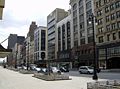
M-1 and Woodward Ave. in downtown Detroit
In the late 1970s, M-1 was truncated in downtown Detroit, as the Woodward Mall area was designated in the area around Cadillac Square. Official MDOT maps and other maps made between the 1970s and the 1990s had conflicting information regarding the routing and terminus of M-1, which had previously reached Jefferson Avenue. In 2001, the southern terminus of M-1 was set at Grand River Avenue, in a spate of jurisdiction transfers between the City of Detroit and MDOT. In 2004, however, the terminus was moved north three blocks to Adams Avenue.Major intersections
See also
- Detroit Financial DistrictDetroit Financial DistrictThe Detroit Financial District is a historic district in downtown Detroit, Michigan. The district was listed on the U.S. National Register of Historic Places on December 14, 2009, and was announced as the featured listing in the National Park Service's weekly list of December 24, 2009.It includes...
- List of buildings located along Woodward Avenue.
- Lower Woodward Avenue Historic DistrictLower Woodward Avenue Historic DistrictThe Lower Woodward Avenue Historic District, also known as Merchant's Row, is a mixed-use retail, commercial, and residential district in downtown Detroit, Michigan, located between Campus Martius Park and Grand Circus Park Historic District at 1201 through 1449 Woodward Avenue and 1400 through...
- Midtown Woodward Historic DistrictMidtown Woodward Historic DistrictThe Midtown Woodward Historic District is a historic district located along Woodward Avenue in Detroit, Michigan. Structures in the district are located between 2951 and 3424 Woodward Avenue, and include structures on the corner of Charlotte Street and Peterboro Street...
- Religious Structures of Woodward Avenue Thematic Resource