
Frontage road
Encyclopedia
Parallel (geometry)
Parallelism is a term in geometry and in everyday life that refers to a property in Euclidean space of two or more lines or planes, or a combination of these. The assumed existence and properties of parallel lines are the basis of Euclid's parallel postulate. Two lines in a plane that do not...
to a higher-speed road, usually a freeway, and feeding it at appropriate points of access (interchanges
Interchange (road)
In the field of road transport, an interchange is a road junction that typically uses grade separation, and one or more ramps, to permit traffic on at least one highway to pass through the junction without directly crossing any other traffic stream. It differs from a standard intersection, at which...
). In many cases, the frontage road is a former alignment of a road already in existence when the limited-access road was built.
In other situations they may be built prior to construction of the limited-access road. In urban areas, frontage roads are frequently one-way
One-way traffic
One-way traffic is traffic that moves in a single direction. A one-way street is a street either facilitating only one-way traffic, or designed to direct vehicles to move in one direction.-General signs:...
roads when they exist on both sides of a highway. In more rural ones, such roads are typically two-way.
Overview
Frontage roads provide access to homes and businesses which would be cut off by a limited access road and connect these locations with roads which have direct access to the main roadway. Frontage roads give indirect access to abutting property along a freeway, either preventing the commercialCommerce
While business refers to the value-creating activities of an organization for profit, commerce means the whole system of an economy that constitutes an environment for business. The system includes legal, economic, political, social, cultural, and technological systems that are in operation in any...
disruption of an urban area
Urban area
An urban area is characterized by higher population density and vast human features in comparison to areas surrounding it. Urban areas may be cities, towns or conurbations, but the term is not commonly extended to rural settlements such as villages and hamlets.Urban areas are created and further...
that the freeway traverses or allowing commercial development of abutting property
Property
Property is any physical or intangible entity that is owned by a person or jointly by a group of people or a legal entity like a corporation...
. At times, they add to the cost of building an expressway due to costs of land acquisition and the costs of paving and maintenance.
However, the benefits of development nearby real estate
Real estate
In general use, esp. North American, 'real estate' is taken to mean "Property consisting of land and the buildings on it, along with its natural resources such as crops, minerals, or water; immovable property of this nature; an interest vested in this; an item of real property; buildings or...
can more than offset the cost of building the frontage roads. Furthermore, a frontage road may be a part of an older highway
Highway
A highway is any public road. In American English, the term is common and almost always designates major roads. In British English, the term designates any road open to the public. Any interconnected set of highways can be variously referred to as a "highway system", a "highway network", or a...
, so the expense of building a frontage road may be slight. And finally, the cost to purchase access rights from adjacent property may exceed the costs to build frontage roads. Conversely, the existence of a frontage road can increase traffic on the main road and be a catalyst for development; hence there is sometimes an explicit decision made to not build a frontage road.
A backage road is a similar concept, but lies on the back side of the land parcels that abut the controlled access's right of way. Like the frontage road, it serves mainly to provide access to those parcels as an alternative to a frontage road.
Advantages in Urban area
When frontage roads are used in urban areas, they create some advantages. One advantage is to separate local traffic from through traffic. When frontage roads are lacking in an urban area the highway is used as a local road. Another advantage occurs when the highway is closed or just obstructed. This pushes traffic off the highway. Where an urban area has frontage roads the traffic can easily bypass the obstruction or closure on the frontage road. Where an urban area has no frontage road traffic congests local roads searching for that elusive passage around the obstruction or closure, since no formal (frontage road) alternative.Disadvantages without Controlled Access Highway
When frontage roads are used without controlling the access to the main line, some disadvantages are created. One disadvantage is that, at every intersection where the local road runs completely through, the number of conflict points increases one fold for each frontage road, since each frontage road is itself another intersection.Three examples are US 190 in East Baton Rouge Parish, Louisiana, LA 1 in West Baton Rouge Parish, Louisiana, and Palatine Road in Cook County, Illinois.
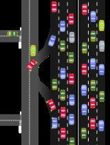
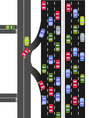
Collector-express
The successor to the concept of service/frontage roads in urban freeways is the collector-express system, which is designed to handle closely spaced interchange ramps without disrupting through traffic. Unlike service roads, the collector lanes are typically high-speed full controlled-access lanes, conforming to freeway requirements.The collector lanes may also be known as a collector/distributor road and slip ramps provide access to and from the express/mainline lanes. Frontage roads may feed into and from collector/distributor roads near some interchanges.
Argentina
In ArgentinaArgentina
Argentina , officially the Argentine Republic , is the second largest country in South America by land area, after Brazil. It is constituted as a federation of 23 provinces and an autonomous city, Buenos Aires...
, especially around Buenos Aires
Buenos Aires
Buenos Aires is the capital and largest city of Argentina, and the second-largest metropolitan area in South America, after São Paulo. It is located on the western shore of the estuary of the Río de la Plata, on the southeastern coast of the South American continent...
, frontage roads known as colectoras can be found next to freeways. Examples include Avenida General Paz
Avenida General Paz
Avenida General Paz is a beltway freeway surrounding the city of Buenos Aires. Roughly following the boundary between the city and Buenos Aires Province, it is one of the few motorways in Argentina that is toll-free...
, Ruta 8, and Ruta 9
National Route 9 (Argentina)
National Route 9 is a major road in Argentina, which runs from the center-east to the northwest of the country, crossing the provinces of Buenos Aires, Santa Fe, Córdoba, Santiago del Estero, Tucumán, Salta and Jujuy...
coming into Buenos Aires.
Canada
The only freeway with a significant remaining network of service roads is the Queen Elizabeth WayQueen Elizabeth Way
The Queen Elizabeth Way, commonly abbreviated as the QEW, is a 400-Series highway in the Canadian province of Ontario. The freeway links Buffalo, New York and the Niagara Peninsula with Toronto. It begins at the Peace Bridge in Fort Erie and travels around the western shore of Lake Ontario, ending...
(QEW). However, most of the slip ramps between St. Catharines
St. Catharines, Ontario
St. Catharines is the largest city in Canada's Niagara Region and the sixth largest urban area in Ontario, Canada, with 97.11 square kilometres of land...
and Mississauga were removed during major reconstruction in the 1970s and 1990s. Service roads are no longer able to directly access the QEW; they have been rerouted to intersections with other major roads which have interchanges with the QEW. Nonetheless, the service roads are positioned too close to the QEW to easily widen the freeway unless all the private properties along the service road are bought out. This would be unlikely in the current political environment.
The only remaining slip ramps connecting to service roads are on the QEW running through St. Catharines
St. Catharines, Ontario
St. Catharines is the largest city in Canada's Niagara Region and the sixth largest urban area in Ontario, Canada, with 97.11 square kilometres of land...
. These dangerous low-standard ramps (due to lack of acceleration/de-acceleration lanes) are due to be replaced in a planned extensive reconstruction of the QEW that is currently underway. Similar service roads and slip ramps exist along Highway 401 through Oshawa
Oshawa, Ontario
Oshawa is a city in Ontario, Canada, on the Lake Ontario shoreline. It lies in Southern Ontario approximately 60 kilometres east of downtown Toronto. It is commonly viewed as the eastern anchor of both the Greater Toronto Area and the Golden Horseshoe. It is now commonly referred to as the most...
, but like through St. Catharines, these are also in the process of being replaced with modern ramps.
Highway 427 had its service roads replaced with a collector-express system in the 1970s. However, it has several RIRO access onramps and offramps to serve residential traffic in addition to its standard parclo interchange
Parclo interchange
A partial cloverleaf interchange or parclo is a modification of a cloverleaf interchange. The parclo interchange was developed by the Ontario Ministry of Transportation as a replacement for the cloverleaf on 400-Series Highways, removing the dangerous weaving patterns and allowing for more...
s with major arterials
Arterial road
An arterial road, or arterial thoroughfare, is a high-capacity urban road. The primary function of an arterial road is to deliver traffic from collector roads to freeways, and between urban centres at the highest level of service possible. As such, many arteries are limited-access roads, or feature...
.
List of Service Roads on the QEW:
- series of broken sections from Cawthra Road in Mississauga to the Garden City SkywayGarden City SkywayThe Garden City Skyway is a major high-level bridge located in St. Catharines and Niagara-on-the-Lake, Ontario, Canada, that allows the Queen Elizabeth Way to cross the Welland Canal without the interruption of a lift bridge. Six lanes of traffic are carried across the bridge, which is 2.2km in...
in St. Catharines.
List of Service Roads on the 403:
- North Service Road at QEW/407 junction to Waterdown Rd, Burlington
- Service Service Road at Guelph Line, Burlington
List of RIRO on the 427:
- Gibbs Road onto North 427
- Eva Road onto/off South 427
- Holiday Drive onto/off South 427
- Eringate Drive onto/off South 427
- Valhalla Inn Road onto North 427
Mexico
In Guadalajara, the López Mateos, Vallarta and Mariano Otero avenues (the latter in the stretch between López Mateos to Niños Héroes) are 2-lane avenues surrounded by two one-way frontage roads. Lázaro Cárdenas Expressway is similar, but with three lanes in both the central road and the frontage roads. Because these frontage roads are considered as part of the avenue itself, the central road is known locally as the "central lanes", whereas the frontage roads are known as "lateral lanes". Turns are always forbidden in the central lanes; drivers wishing to make a turn must leave the central lanes and make the turn from the lateral lanes.The Netherlands
Frontage roads are common in the Netherlands and detailed in the Dutch national Design manual for bicycle traffic as per pages 121 and 127 where they are referred to as parallel roads. In the Netherlands, engineers have used frontage roads to benefit cyclists as well as automobiles. Because frontage roads only carry local traffic, the speed on these roads is low (their speed limit is 30 km/h), making them an ideal environment for bicyclists. Because the speed and volume is so low, no additional treatments are needed to make a service road a safe bike facility. In the Netherlands, service roads are often linked together with bike paths to help create a comprehensive bicycle route, with the bike path links serving as barriers to through motor traffic. Since service roads serve a dual purpose, they are an inexpensive way to create routes in cycling network, compared to cycletracks or stand-alone bike paths. Extensive amounts of information on frontage roads can be found on Northeastern's webpage.People's Republic of China
In the People's Republic of ChinaPeople's Republic of China
China , officially the People's Republic of China , is the most populous country in the world, with over 1.3 billion citizens. Located in East Asia, the country covers approximately 9.6 million square kilometres...
mainland
Mainland China
Mainland China, the Chinese mainland or simply the mainland, is a geopolitical term that refers to the area under the jurisdiction of the People's Republic of China . According to the Taipei-based Mainland Affairs Council, the term excludes the PRC Special Administrative Regions of Hong Kong and...
, roads running next to expressways
Expressways of China
The Expressway Network of the People's Republic of China is one of the longest in the world. The network is also known as National Trunk Highway System . The total length of China's expressways was at the end of 2010, the world's second longest only after the United States and slightly longer...
, taking outgoing traffic and feeding incoming traffic, are called either service roads or auxiliary roads (fudao locally). Where expressways cross larger urban areas, such frontage roads may run next to the expressway itself. Much of the Beijing portion of the Jingkai Expressway
Jingkai Expressway
The Jingkai Expressway is an expressway in China which links Beijing to Kaifeng. At present, it is approximately 40 km in length in the Beijing section....
, for example, has, in fact, China National Highway 106
China National Highway 106
China National Highway 106 is a road from Beijing to Guangzhou.It leaves Beijing at Yuquanying and heads to Gu'an, Bazhou , Kaifeng , Ezhou , and eventually Guangzhou on the south China coast....
acting as a split-direction frontage road.
Hong Kong
Frontage roads exist both in city and along major expressways between new towns. Gloucester RoadGloucester Road
Road:* Gloucester Road, London* Gloucester Road tube station* Gloucester Road, Hong Kong* Gloucester Road, Bristol A38 through Horfield, Bristol...
has frontage road running parallel of it from east to west. Cheung Tung Road serves as the frontage road for North Lantau Highway, Hiram's Highway for New Hiram's Highway, and Tai Wo Service Road West and Tai Wo Service Road East for Fanling Highway. Castle Peak Road serves the purpose as a frontage road of Tuen Mun Road to some extent.
India
Service roads or Service lanes in India exist on most high density dual carriagewayDual carriageway
A dual carriageway is a class of highway with two carriageways for traffic travelling in opposite directions separated by a central reservation...
roads and dual carriageway highways.
Michigan
Frontage roads are also common in Metro DetroitMetro Detroit
The Detroit metropolitan area, often referred to as Metro Detroit, is the metropolitan area located in Southeast Michigan centered on the city of Detroit which shares an international border with Windsor, Ontario. The Detroit metropolitan area is the second largest U.S. metropolitan area...
, where they are usually referred to as "service drives." As in Texas, they typically run one way with frequent slip ramps to and from the limited access roadway, with Texas U-turn
Texas U-turn
A Texas U-turn, or Texas Turnaround, is a lane allowing cars traveling on one side of a one-way frontage road to U-turn into the opposite frontage road . These are typically controlled by a yield sign, allow traffic to bypass the two traffic signals, and avoid crossing the highway traffic at-grade...
s at or near many intersections. Unlike Texas, there is usually little commercial development situated along the frontage road itself (see example); the road serves to provide access to the freeway from existing residential streets and commercial surface thoroughfares. Also unlike in many locales in urban Texas, where an exit ramp may actually precede the entrance ramp for the previous interchange to facilitate access to businesses situated directly on the frontage road (in effect, the two interchanges overlap along the frontage road), Michigan slip ramps to and from frontage roads are generally positioned as they normally would be in the absence of the frontage road. Motorists entering and exiting the freeway are not sharing the frontage road simultaneously to as large a degree, reducing weaving. Access to the frontage road between exits is provided by turnarounds and frequent bridging, generally every 1/2 mile, between exits.
Michigan left hand turns
Michigan left
A Michigan left is an at-grade intersection design which replaces each left turn with a permutation of a U-turn and a right turn. The design was given the name due to its frequent use along Michigan roads and highways since the late 1960s. In other contexts, the intersection is called a median...
are also quite common at surface street-frontage road intersections, with dedicated turnaround lanes (similar to the Texas U-turn) built over the freeway on separate bridges approximately 100 meters from the main intersection and bridging.
With the exceptions of Interstate 275 and the freeway portion of M-53
M-53 (Michigan highway)
M-53 is a gateway route to The Thumb region of the US state of Michigan, carrying vacationers to the many cottages and resorts located on Saginaw Bay and Lake Huron in the vicinity of Caseville and Port Austin. This highway is also used to transport agricultural and manufactured products from the...
, every Metro Detroit freeway has a frontage road along it for at least a portion of its length. Several other freeways outside Metro Detroit use these as well.
There are no other Michigan frontage roads running more than one mile in length outside of the Metro Detroit area. New freeway construction in Michigan has not included frontage roads since the completion of Interstate 696
Interstate 696
Interstate 696 is an intrastate Interstate Highway entirely within the US state of Michigan. I-696 is also known as the Walter P. Reuther Freeway, named for a prominent figure in early automobile factory labor union activity. I-696 is a spur route, partially circling the city of Detroit, but...
, most of which was constructed along the rights of way of major surface arteries, in 1989.
New York
One-way service roads on either sides of highway are relatively common in New York City. Due to the high urban density, this design allows rapid access on and off the highway while also providing a viable alternate route in the case of accidents and traffic. In the borough of Queens, the Van Wyck Expressway has this system implemented for most of its length. On Long Island, the Long Island Expressway (Interstate 495), has one-way service roads on each side of the expressway for most of its length from the Queens–Midtown Tunnel to RiverheadRiverhead (town), New York
The town of Riverhead is in Suffolk County, New York, on the north shore of Long Island. The population was 33,506 at the 2010 census. The name signifies that the mouth of the Peconic River is in this town...
.
Texas
Texas U-turn
A Texas U-turn, or Texas Turnaround, is a lane allowing cars traveling on one side of a one-way frontage road to U-turn into the opposite frontage road . These are typically controlled by a yield sign, allow traffic to bypass the two traffic signals, and avoid crossing the highway traffic at-grade...
s, allowing drivers to avoid stopping for traffic lights when making a U-turn.
Frontage roads are often built as part of a multi-phase plan to construct new limited access highways. They initially serve as a highway with access to local business before the freeway is constructed years later. After the completion of the freeway, frontage roads serve as a major thoroughfare for local activity, such as with the Katy Freeway project in Greater Houston
Greater Houston
Houston–Sugar Land–Baytown is a 10-county metropolitan area defined by the Office of Management and Budget. It is located along the Gulf Coast region in the U.S. state of Texas...
. In several cases, a long range plan has called for a future freeway, but the design is either changed or the project canceled before completion.
Nicknames for frontage roads vary within the state of Texas. In Houston and East Texas
East Texas
East Texas is a distinct geographic and ecological area in the U.S. state of Texas.According to the Handbook of Texas, the East Texas area "may be separated from the rest of Texas roughly by a line extending from the Red River in north central Lamar County southwestward to east central Limestone...
they are called feeders. Dallas and Fort Worth
Fort Worth, Texas
Fort Worth is the 16th-largest city in the United States of America and the fifth-largest city in the state of Texas. Located in North Central Texas, just southeast of the Texas Panhandle, the city is a cultural gateway into the American West and covers nearly in Tarrant, Parker, Denton, and...
residents call their frontage roads "service roads" or "access roads", and "access roads" is the predominant term used in San Antonio
San Antonio, Texas
San Antonio is the seventh-largest city in the United States of America and the second-largest city within the state of Texas, with a population of 1.33 million. Located in the American Southwest and the south–central part of Texas, the city serves as the seat of Bexar County. In 2011,...
. El Paso
El Paso, Texas
El Paso, is a city in and the county seat of El Paso County, Texas, United States, and lies in far West Texas. In the 2010 census, the city had a population of 649,121. It is the sixth largest city in Texas and the 19th largest city in the United States...
residents call their frontage roads "gateways." In Austin
Austin, Texas
Austin is the capital city of the U.S. state of :Texas and the seat of Travis County. Located in Central Texas on the eastern edge of the American Southwest, it is the fourth-largest city in Texas and the 14th most populous city in the United States. It was the third-fastest-growing large city in...
, however, they use the state's official term of "frontage roads".
In 2002, the Texas Department of Transportation
Texas Department of Transportation
The Texas Department of Transportation is a governmental agency in the U.S. state of Texas. Its stated mission is to "work cooperatively to provide safe, effective and efficient movement of people and goods" throughout the state...
proposed to discontinue building frontage roads on new freeways, citing studies that suggest frontage roads increase congestion. However, this proposal was widely ridiculed and criticized and was dropped later the same year.
The Stemmons Freeway in Dallas
Dallas, Texas
Dallas is the third-largest city in Texas and the ninth-largest in the United States. The Dallas-Fort Worth Metroplex is the largest metropolitan area in the South and fourth-largest metropolitan area in the United States...
illustrates the practicability of the frontage road: the real estate developer John Stemmons offered free land to the Texas Highway commission in which to build a freeway (Interstate 35E
Interstate 35E (Texas)
Interstate 35E , an Interstate Highway, is the eastern half of Interstate 35 where it splits to serve different cities in Texas. I-35 splits into two branch routes, I-35W and I-35E at Hillsboro. I-35E runs north for , maintaining I-35's sequence of exit numbers. It runs through Dallas before...
) on the condition that the state
Texas Department of Transportation
The Texas Department of Transportation is a governmental agency in the U.S. state of Texas. Its stated mission is to "work cooperatively to provide safe, effective and efficient movement of people and goods" throughout the state...
build the freeway with frontage roads that would give access to undeveloped property
Property
Property is any physical or intangible entity that is owned by a person or jointly by a group of people or a legal entity like a corporation...
that he owned along the freeway corridor. The state was able to reduce its costs (largely the cost of land acquisition) of building the freeway, and didn't need to acquire and demolish developed property; the developer profited from development along the freeway. San Antonio
San Antonio, Texas
San Antonio is the seventh-largest city in the United States of America and the second-largest city within the state of Texas, with a population of 1.33 million. Located in the American Southwest and the south–central part of Texas, the city serves as the seat of Bexar County. In 2011,...
developer Charles Martin Wender used the same tactic for his Westover Hills development, offering free land through the middle of his property for SH 151 as well as paying half the costs for the initial frontage road construction. Following Wender's lead, several neighboring landowners also donated right-of-way for the route.
The Carolinas
Frontage roads are common on interstate highways in North CarolinaNorth Carolina
North Carolina is a state located in the southeastern United States. The state borders South Carolina and Georgia to the south, Tennessee to the west and Virginia to the north. North Carolina contains 100 counties. Its capital is Raleigh, and its largest city is Charlotte...
and South Carolina
South Carolina
South Carolina is a state in the Deep South of the United States that borders Georgia to the south, North Carolina to the north, and the Atlantic Ocean to the east. Originally part of the Province of Carolina, the Province of South Carolina was one of the 13 colonies that declared independence...
. Some of these road have houses facing the highways which they parallel. They may also have highway services, as most of them are located near interchanges
Interchange (road)
In the field of road transport, an interchange is a road junction that typically uses grade separation, and one or more ramps, to permit traffic on at least one highway to pass through the junction without directly crossing any other traffic stream. It differs from a standard intersection, at which...
. Most frontage roads in the Carolinas do not have ramps leading to and from their respective highways; rather, as mentioned before, most are located near interchanges, which allows people to exit the highway and go around to the frontage road if needed.