
Via Maris
Encyclopedia
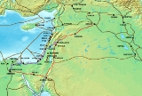
Via Maris is the modern name for an ancient trade route
, dating from the early Bronze Age
, linking Egypt
with the northern empires of Syria
, Anatolia
and Mesopotamia
— modern day Iran
, Iraq
, Turkey and Syria.
 Its earlier name was "Way of the Philistines
", a reference to a passageway through the Philistine Plain (which today consists of Israel's southern coastal plain and the Gaza Strip
). From the Philistine Plain, the Way continues north through the Sharon
. At Dor (near modern Hadera
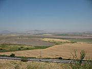
) the Way branches into two Ways — one continuing along the Mediterranean coast, and the other following an inland route through Megiddo, the Jezreel Valley
, the Sea of Galilee
and Dan
.
"Via Maris" is Latin and means "the Way of the Sea". The name is based on a passage from the Vulgate
(the New Testament
in Latin translation), Matthew 4:15:
That verse paraphrases Isaiah 9:1 (or 8:23):
Some consider the name Via Maris a misnomer and instead prefer to call this route the Great Trunk Road.
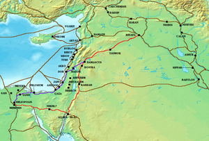
Together with the King's Highway
, the Via Maris was one of the major trade routes connecting Egypt
and the Levant
with Anatolia
and Mesopotamia
. The Via Maris was crossed by other trading routes, so that one could travel from Africa to Europe or from Asia to Africa. It began in al-Qantara and went east to Pelusium
, following the northern coast of Sinai
through el-Arish and Rafah
. From there it followed the coast of Canaan
through Gaza
, Ashkelon
, Ashdod, Joppa, and Dor
before turning east again through Megiddo and the Jezreel Valley
until it reached Tiberias on the Sea of Galilee
. Again turning northward along the shore, the Via Maris passed through Migdal, Capernaum
, and Hazor
. From Hazor it crossed the northern River Jordan at Jacob's Ford then climbed sharply over the Golan Heights and wound its way northeast into Damascus
. Here travellers could continue on the King's Highway as far as the Euphrates River
or proceed northward into Anatolia.
Trade route
A trade route is a logistical network identified as a series of pathways and stoppages used for the commercial transport of cargo. Allowing goods to reach distant markets, a single trade route contains long distance arteries which may further be connected to several smaller networks of commercial...
, dating from the early Bronze Age
Bronze Age
The Bronze Age is a period characterized by the use of copper and its alloy bronze as the chief hard materials in the manufacture of some implements and weapons. Chronologically, it stands between the Stone Age and Iron Age...
, linking Egypt
Egypt
Egypt , officially the Arab Republic of Egypt, Arabic: , is a country mainly in North Africa, with the Sinai Peninsula forming a land bridge in Southwest Asia. Egypt is thus a transcontinental country, and a major power in Africa, the Mediterranean Basin, the Middle East and the Muslim world...
with the northern empires of Syria
Syria
Syria , officially the Syrian Arab Republic , is a country in Western Asia, bordering Lebanon and the Mediterranean Sea to the West, Turkey to the north, Iraq to the east, Jordan to the south, and Israel to the southwest....
, Anatolia
Anatolia
Anatolia is a geographic and historical term denoting the westernmost protrusion of Asia, comprising the majority of the Republic of Turkey...
and Mesopotamia
Mesopotamia
Mesopotamia is a toponym for the area of the Tigris–Euphrates river system, largely corresponding to modern-day Iraq, northeastern Syria, southeastern Turkey and southwestern Iran.Widely considered to be the cradle of civilization, Bronze Age Mesopotamia included Sumer and the...
— modern day Iran
Iran
Iran , officially the Islamic Republic of Iran , is a country in Southern and Western Asia. The name "Iran" has been in use natively since the Sassanian era and came into use internationally in 1935, before which the country was known to the Western world as Persia...
, Iraq
Iraq
Iraq ; officially the Republic of Iraq is a country in Western Asia spanning most of the northwestern end of the Zagros mountain range, the eastern part of the Syrian Desert and the northern part of the Arabian Desert....
, Turkey and Syria.
Philistines
Philistines , Pleshet or Peleset, were a people who occupied the southern coast of Canaan at the beginning of the Iron Age . According to the Bible, they ruled the five city-states of Gaza, Askelon, Ashdod, Ekron and Gath, from the Wadi Gaza in the south to the Yarqon River in the north, but with...
", a reference to a passageway through the Philistine Plain (which today consists of Israel's southern coastal plain and the Gaza Strip
Gaza Strip
thumb|Gaza city skylineThe Gaza Strip lies on the Eastern coast of the Mediterranean Sea. The Strip borders Egypt on the southwest and Israel on the south, east and north. It is about long, and between 6 and 12 kilometres wide, with a total area of...
). From the Philistine Plain, the Way continues north through the Sharon
Sharon
Sharon can be a female name which can be spelled with one "r" or two . It also refers to several places in the world.It derives from a Israelite place name meaning "forest" in Hebrew, referring to a fertile plain near the coast of Israel. This gives its name to a type of flowering shrub, the rose...
. At Dor (near modern Hadera
Hadera
Hadera is a city located in the Haifa District of Israel approximately from the major cities of Tel Aviv and Haifa. The city is located along of the Israeli Mediterranean Coastal Plain...
) the Way branches into two Ways — one continuing along the Mediterranean coast, and the other following an inland route through Megiddo, the Jezreel Valley
Jezreel Valley
-Etymology:The Jezreel Valley takes its name from the ancient city of Jezreel which was located on a low hill overlooking the southern edge of the valley, though some scholars think that the name of the city originates from the name of the clan which founded it, and whose existence is mentioned in...
, the Sea of Galilee
Sea of Galilee
The Sea of Galilee, also Kinneret, Lake of Gennesaret, or Lake Tiberias , is the largest freshwater lake in Israel, and it is approximately in circumference, about long, and wide. The lake has a total area of , and a maximum depth of approximately 43 m...
and Dan
Tribe of Dan
The Tribe of Dan, also sometimes spelled as "Dann", was one of the Tribes of Israel. Though known mostly from biblical sources, they were possibly descendants of the Denyen Sea Peoples who joined with Hebrews...
.
"Via Maris" is Latin and means "the Way of the Sea". The name is based on a passage from the Vulgate
Vulgate
The Vulgate is a late 4th-century Latin translation of the Bible. It was largely the work of St. Jerome, who was commissioned by Pope Damasus I in 382 to make a revision of the old Latin translations...
(the New Testament
New Testament
The New Testament is the second major division of the Christian biblical canon, the first such division being the much longer Old Testament....
in Latin translation), Matthew 4:15:
- terra Zabulon et terra Nephthalim via maris trans Iordanen Galilaeae gentium.
That verse paraphrases Isaiah 9:1 (or 8:23):
- In the past he humbled the land of Zebulun and the land of Naphtali, but in the future he will honor Galilee of the Gentiles, by the way of the sea, along the Jordan.
Some consider the name Via Maris a misnomer and instead prefer to call this route the Great Trunk Road.
Together with the King's Highway
King's Highway (ancient)
The King’s Highway was a trade route of vital importance to the ancient Middle East. It began in Egypt, and stretched across the Sinai Peninsula to Aqaba. From there it turned northward across Jordan, leading to Damascus and the Euphrates River....
, the Via Maris was one of the major trade routes connecting Egypt
Egypt
Egypt , officially the Arab Republic of Egypt, Arabic: , is a country mainly in North Africa, with the Sinai Peninsula forming a land bridge in Southwest Asia. Egypt is thus a transcontinental country, and a major power in Africa, the Mediterranean Basin, the Middle East and the Muslim world...
and the Levant
Levant
The Levant or ) is the geographic region and culture zone of the "eastern Mediterranean littoral between Anatolia and Egypt" . The Levant includes most of modern Lebanon, Syria, Jordan, Israel, the Palestinian territories, and sometimes parts of Turkey and Iraq, and corresponds roughly to the...
with Anatolia
Anatolia
Anatolia is a geographic and historical term denoting the westernmost protrusion of Asia, comprising the majority of the Republic of Turkey...
and Mesopotamia
Mesopotamia
Mesopotamia is a toponym for the area of the Tigris–Euphrates river system, largely corresponding to modern-day Iraq, northeastern Syria, southeastern Turkey and southwestern Iran.Widely considered to be the cradle of civilization, Bronze Age Mesopotamia included Sumer and the...
. The Via Maris was crossed by other trading routes, so that one could travel from Africa to Europe or from Asia to Africa. It began in al-Qantara and went east to Pelusium
Pelusium
Pelusium was a city in the eastern extremes of Egypt's Nile Delta, 30 km to the southeast of the modern Port Said. Alternative names include Sena and Per-Amun , Pelousion , Sin , Seyân , and Tell el-Farama...
, following the northern coast of Sinai
Sinai Peninsula
The Sinai Peninsula or Sinai is a triangular peninsula in Egypt about in area. It is situated between the Mediterranean Sea to the north, and the Red Sea to the south, and is the only part of Egyptian territory located in Asia as opposed to Africa, effectively serving as a land bridge between two...
through el-Arish and Rafah
Rafah
Rafah , also known as Rafiah, is a Palestinian city in the southern Gaza Strip. Located south of Gaza, Rafah's population of 71,003 is overwhelmingly made up of Palestinian refugees. Rafah camp and Tall as-Sultan form separate localities. Rafah is the district capital of the Rafah Governorate...
. From there it followed the coast of Canaan
Canaan
Canaan is a historical region roughly corresponding to modern-day Israel, Palestine, Lebanon, and the western parts of Jordan...
through Gaza
Gaza
Gaza , also referred to as Gaza City, is a Palestinian city in the Gaza Strip, with a population of about 450,000, making it the largest city in the Palestinian territories.Inhabited since at least the 15th century BC,...
, Ashkelon
Ashkelon
Ashkelon is a coastal city in the South District of Israel on the Mediterranean coast, south of Tel Aviv, and north of the border with the Gaza Strip. The ancient seaport of Ashkelon dates back to the Neolithic Age...
, Ashdod, Joppa, and Dor
Dor
Tel Dor , is an archeological site located on Israel's Mediterranean coast, about 30 km south of Haifa. Lying on a small headland at the north side of a protected inlet, it is identified with D-jr of Egyptian sources, Biblical Dor, and with Dor/Dora of Greek and Roman sources...
before turning east again through Megiddo and the Jezreel Valley
Jezreel Valley
-Etymology:The Jezreel Valley takes its name from the ancient city of Jezreel which was located on a low hill overlooking the southern edge of the valley, though some scholars think that the name of the city originates from the name of the clan which founded it, and whose existence is mentioned in...
until it reached Tiberias on the Sea of Galilee
Sea of Galilee
The Sea of Galilee, also Kinneret, Lake of Gennesaret, or Lake Tiberias , is the largest freshwater lake in Israel, and it is approximately in circumference, about long, and wide. The lake has a total area of , and a maximum depth of approximately 43 m...
. Again turning northward along the shore, the Via Maris passed through Migdal, Capernaum
Capernaum
Capernaum was a fishing village in the time of the Hasmoneans. Located on the northern shore of the Sea of Galilee. It had a population of about 1,500. Archaeological excavations have revealed two ancient synagogues built one over the other...
, and Hazor
Hazor
Hazor is the name of several places in the biblical and modern Israel:Biblical locations:* Tel Hazor, site of an ancient fortified city in the Upper Galilee, among the most important Caananite towns, and the largest ancient ruin in modern Israel and UNESCO World Heritage Site.* Hazor, A town in...
. From Hazor it crossed the northern River Jordan at Jacob's Ford then climbed sharply over the Golan Heights and wound its way northeast into Damascus
Damascus
Damascus , commonly known in Syria as Al Sham , and as the City of Jasmine , is the capital and the second largest city of Syria after Aleppo, both are part of the country's 14 governorates. In addition to being one of the oldest continuously inhabited cities in the world, Damascus is a major...
. Here travellers could continue on the King's Highway as far as the Euphrates River
Euphrates
The Euphrates is the longest and one of the most historically important rivers of Western Asia. Together with the Tigris, it is one of the two defining rivers of Mesopotamia...
or proceed northward into Anatolia.