
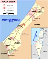
Rafah
Encyclopedia
Rafah also known as Rafiah, is a Palestinian
city in the southern Gaza Strip
. Located 30 kilometres (18.6 mi) south of Gaza
, Rafah's population of 71,003 is overwhelmingly made up of Palestinian refugee
s. Rafah camp
and Tall as-Sultan
form separate localities. Rafah is the district capital of the Rafah Governorate
. Yasser Arafat International Airport
, Gaza's only airport, is located just south of the city; the airport operated from 1998 to 2001, when it was bombed and bulldozed by the Israel Defense Forces
(IDF) after the killing of Israeli soldiers by members of Hamas
. Rafah is the site of the Rafah Border Crossing, the only crossing between the Gaza Strip and Egypt
.
ns, "Ῥαφία, Rhaphia" by the Greek
s, "Raphia" by Romans
, "" [pronounced Rafiach] by the Israelites, "Rafh" by the Arab Caliphate.
Seti I
, from 1303 BCE as Rph, and as the first stop on Pharaoh Shoshenq I
's campaign to the Levant
in 925 BC. In 720 BCE it was the site of the Assyria
n king Sargon II
's victory over the Egyptians
, and in 217 BC the Battle of Raphia
was fought between the victorious Ptolemy IV and Antiochus III
. (It is said to be one of the largest battles ever fought in the Levant, with over a hundred thousand soldiers and hundreds of elephant
s).
The town was conquered by Alexander Yannai and held by the Hasmonean
s until it was rebuilt in the time of Pompey
and Gabinius
; the latter seems to have done the actual work of restoration for the era of the town dates from 57 BCE. Rafah is mentioned in Strabo
(16,2, 31), the Antonine Itinerary
, and is depicted on the Map of Madaba.
A Jewish community settled in the city in the 9th and 10th centuries and again in the 12th, although in the 11th century it suffered a decline and in 1080 they migrated to Ashkelon
. A Samaritan
community also lived there during this period. Like most cities of southern Palestine
, ancient Rafah had a landing place on the coast (now Tell Rafah), while the main city was inland. During the Byzantine
period, it was a diocese
.
period, and one of the towns captured by the Rashidun army
under general 'Amr ibn al-'As
in 635 CE. Under the Umayyad
s and Abbasid
s, Rafah was the southernmost border of Jund Filastin
("District of Palestine"). According to Arab geographer al-Ya'qubi, it was the last town in the Province of Syria and on the road from Ramla
to Egypt
.
In 1226, Arab geographer Yaqut al-Hamawi
writes of Rafah's former importance in the early Arab period, saying it was "of old a flourishing town, with a market, and a mosque
, and hostelries." However, he goes on to say that in its current state, Rafah was in ruins, but was an Ayyubid postal station on the road to Egypt after nearby Deir al-Balah. Ottoman
records in the 16th century show a small village of 16 taxpayers.
Rafah was the boundary between the provinces of Egypt and Syria. In 1881, Archduke Ludwig Salvator of Austria wrote
commanded by Napoleon Bonaparte passed through Rafah during the invasion of Egypt and Syria.
, and used it as a base for their attack on Gaza. The presence of the army bases was an economic draw that brought people back to the city, and in 1922 it had a population of 600. By 1948, the population had risen to 2,500. After the 1948 Arab-Israeli War
, the refugee camps were established. In 1956 the Israeli army - in retaliation for a series of raids executed by the fedayeen
- killed 111 people, including 103 refugees, in the Palestinian refugee camp of Rafah. During the 1967 Six-Day War
, the Israel Defense Force captured Rafah with the Sinai Peninsula
and Gaza Strip
, the population was about 55,000, of whom only 11,000 lived in Rafah itself.
 In the summer of 1971, the IDF, under General Ariel Sharon
(then head of the IDF southern command
), destroyed approximately 500 houses in the refugee camps of Rafah in order to create patrol roads for Israeli forces. These demolitions displaced nearly 4000 people. Israel established the Brazil and Canada housing projects to accommodate displaced Palestinians and to provide better conditions in the hopes of integrating the refugees into the general population and its standard of living; Brazil is immediate south of Rafah, while Canada was just across the border in Sinai. Both were named because UN peacekeeping troops from those respective countries had maintained barracks in those locations. After the 1978 Camp David Accords
mandated the repatriation of Canada project refugees to the Gaza Strip, the Tel al-Sultan project, northwest of Rafah, was built to accommodate them.
Because of the Camp David Accords, Israel withdrew from the Sinai Peninsula and Rafah was divided, with part of it on the Egyptian side of the border under Egyptian rule. To cope with the division of the town, smugglers made tunnels under the border, connecting the two parts and permitting the smuggling of goods and persons.
During the 2011 Egyptian protests, anti-government rioters attacked and killed three police officers in the Egyptian part of the town.
On 29 January 2011, the Church of St. George and the National Library were burnt down in the Egyptian part of the town after first removing all Islamic books to safety.
In the 1997 Palestinian Central Bureau of Statistics
(PCBS) census, Rafah and its adjacent camp had a combined population of 91,181, Tall as-Sultan
was listed with a further 17,141. Refugee
s made up 80.3% of the entire population. In the 1997 census, Rafah's (together with Rafah camp
) gender distribution was 50.5% male and 49.5% female.
In the 2006 PCBS estimate, Rafah city had a population of 71,003, Rafah camp
and Tall as-Sultan
form separate localities for census purposes, having populations of 59,983 and 24,418, respectively.
from the Gaza Strip. A European Union commission began monitoring
the crossing in November 2005 amid Israeli security concerns, and in April 2006, Palestinian Authority Chairman Mahmoud Abbas
's Presidential Guard assumed responsibility for the site on the Palestinian Authority side. On the Egyptian side, the responsibility is assumed by the 750 Border Guards allowed by an agreement of Egypt with Israel. The agreement was signed in November 2005 forced by US pressure, and specifies that it is under security requirements demanded by Israel.
On January 23, 2008, at 2 am, the border crossing was breached after gunmen set off an explosion nearby, destroying part of the Israeli Gaza Strip barrier
. Over the next four days, approximately 700,000 Palestinians crossed into Egypt, most planning to buy supplies and return to Gaza. A smaller number of Egyptians crossed into Gaza.
On June 1, 2010, in the midst of international uproar following Israel's attack on a relief boat, Egypt announced it was opening the border crossing.
On May 28, 2011, in a corrective measure to the ousted president Hosni Mubarak’s policy towards Palestine and its people, Egypt after four years from its side has ended the Gaza siege by permanently reopening the Rafah border crossing, allowing Palestinians the monitored freedom to cross into the country. Worth noting that the first to cross were ambulance cars carrying patients with much needed medical treatment to Cairo.
However in mid-June 2011 the crossing was closed for several days and after that only a few hundred were allowed to cross each day compared with 'thousands' who applied to cross each day. Egypt reportedly agreed to allow a minimum of 500 people to cross each day.
http://news.xinhuanet.com/english2010/world/2011-06/08/c_13917741.htm
Palestinian people
The Palestinian people, also referred to as Palestinians or Palestinian Arabs , are an Arabic-speaking people with origins in Palestine. Despite various wars and exoduses, roughly one third of the world's Palestinian population continues to reside in the area encompassing the West Bank, the Gaza...
city in the southern Gaza Strip
Gaza Strip
thumb|Gaza city skylineThe Gaza Strip lies on the Eastern coast of the Mediterranean Sea. The Strip borders Egypt on the southwest and Israel on the south, east and north. It is about long, and between 6 and 12 kilometres wide, with a total area of...
. Located 30 kilometres (18.6 mi) south of Gaza
Gaza
Gaza , also referred to as Gaza City, is a Palestinian city in the Gaza Strip, with a population of about 450,000, making it the largest city in the Palestinian territories.Inhabited since at least the 15th century BC,...
, Rafah's population of 71,003 is overwhelmingly made up of Palestinian refugee
Palestinian refugee
Palestinian refugees or Palestine refugees are the people and their descendants, predominantly Palestinian Arabic-speakers, who fled or were expelled from their homes during and after the 1948 Palestine War, within that part of the British Mandate of Palestine, that after that war became the...
s. Rafah camp
Rafah camp
Rafah camp is one of eight Palestinian refugee camps in the Gaza Strip. It is located in the Rafah Governorate along the Egyptian-Palestinian Authority border. It was established in 1949 and currently forms part of the city of Rafah...
and Tall as-Sultan
Tall as-Sultan
Tall as-Sultan is one of eight Palestinian refugee camps in the Gaza Strip. It is located in the Rafah Governorate just North of Rafah city and Rafah camp. It was established mainly to absorb refugees repatriated from Canada Camp....
form separate localities. Rafah is the district capital of the Rafah Governorate
Rafah Governorate
The Rafah Governorate is a governorate of the Palestinian National Authority in the southernmost portion of the Gaza Strip. Its district capital or muhfaza is the city of Rafah located on the border with Egypt. According to the Palestinian Central Bureau of Statistics the governorate had a...
. Yasser Arafat International Airport
Yasser Arafat International Airport
Yasser Arafat International Airport , formerly Gaza International Airport and Dahaniya International Airport, is located in the Gaza Strip, in Rafah close to the Egyptian border....
, Gaza's only airport, is located just south of the city; the airport operated from 1998 to 2001, when it was bombed and bulldozed by the Israel Defense Forces
Israel Defense Forces
The Israel Defense Forces , commonly known in Israel by the Hebrew acronym Tzahal , are the military forces of the State of Israel. They consist of the ground forces, air force and navy. It is the sole military wing of the Israeli security forces, and has no civilian jurisdiction within Israel...
(IDF) after the killing of Israeli soldiers by members of Hamas
Hamas
Hamas is the Palestinian Sunni Islamic or Islamist political party that governs the Gaza Strip. Hamas also has a military wing, the Izz ad-Din al-Qassam Brigades...
. Rafah is the site of the Rafah Border Crossing, the only crossing between the Gaza Strip and Egypt
Egypt
Egypt , officially the Arab Republic of Egypt, Arabic: , is a country mainly in North Africa, with the Sinai Peninsula forming a land bridge in Southwest Asia. Egypt is thus a transcontinental country, and a major power in Africa, the Mediterranean Basin, the Middle East and the Muslim world...
.
Etymology
Over the ages it has been known as "Robihwa" by the ancient Egyptians, "Rafihu" by the AssyriaAssyria
Assyria was a Semitic Akkadian kingdom, extant as a nation state from the mid–23rd century BC to 608 BC centred on the Upper Tigris river, in northern Mesopotamia , that came to rule regional empires a number of times through history. It was named for its original capital, the ancient city of Assur...
ns, "Ῥαφία, Rhaphia" by the Greek
Greece
Greece , officially the Hellenic Republic , and historically Hellas or the Republic of Greece in English, is a country in southeastern Europe....
s, "Raphia" by Romans
Ancient Rome
Ancient Rome was a thriving civilization that grew on the Italian Peninsula as early as the 8th century BC. Located along the Mediterranean Sea and centered on the city of Rome, it expanded to one of the largest empires in the ancient world....
, "" [pronounced Rafiach] by the Israelites, "Rafh" by the Arab Caliphate.
Antiquity
Rafah has a history stretching back thousands of years. It was first recorded in an inscription of Egyptian PharaohPharaoh
Pharaoh is a title used in many modern discussions of the ancient Egyptian rulers of all periods. The title originates in the term "pr-aa" which means "great house" and describes the royal palace...
Seti I
Seti I
Menmaatre Seti I was a Pharaoh of Ancient Egypt , the son of Ramesses I and Queen Sitre, and the father of Ramesses II...
, from 1303 BCE as Rph, and as the first stop on Pharaoh Shoshenq I
Shoshenq I
Hedjkheperre Setepenre Shoshenq I , , also known as Sheshonk or Sheshonq I , was a Meshwesh Berber king of Egypt—of Libyan ancestry—and the founder of the Twenty-second Dynasty...
's campaign to the Levant
Levant
The Levant or ) is the geographic region and culture zone of the "eastern Mediterranean littoral between Anatolia and Egypt" . The Levant includes most of modern Lebanon, Syria, Jordan, Israel, the Palestinian territories, and sometimes parts of Turkey and Iraq, and corresponds roughly to the...
in 925 BC. In 720 BCE it was the site of the Assyria
Assyria
Assyria was a Semitic Akkadian kingdom, extant as a nation state from the mid–23rd century BC to 608 BC centred on the Upper Tigris river, in northern Mesopotamia , that came to rule regional empires a number of times through history. It was named for its original capital, the ancient city of Assur...
n king Sargon II
Sargon II
Sargon II was an Assyrian king. Sargon II became co-regent with Shalmaneser V in 722 BC, and became the sole ruler of the kingdom of Assyria in 722 BC after the death of Shalmaneser V. It is not clear whether he was the son of Tiglath-Pileser III or a usurper unrelated to the royal family...
's victory over the Egyptians
Egyptians
Egyptians are nation an ethnic group made up of Mediterranean North Africans, the indigenous people of Egypt.Egyptian identity is closely tied to geography. The population of Egypt is concentrated in the lower Nile Valley, the small strip of cultivable land stretching from the First Cataract to...
, and in 217 BC the Battle of Raphia
Battle of Raphia
The Battle of Raphia, also known as the Battle of Gaza, was a battle fought on 22 June 217 BC near modern Rafah between the forces of Ptolemy IV Philopator, king of Egypt and Antiochus III the Great of the Seleucid kingdom during the Syrian Wars...
was fought between the victorious Ptolemy IV and Antiochus III
Antiochus III the Great
Antiochus III the Great Seleucid Greek king who became the 6th ruler of the Seleucid Empire as a youth of about eighteen in 223 BC. Antiochus was an ambitious ruler who ruled over Greater Syria and western Asia towards the end of the 3rd century BC...
. (It is said to be one of the largest battles ever fought in the Levant, with over a hundred thousand soldiers and hundreds of elephant
Elephant
Elephants are large land mammals in two extant genera of the family Elephantidae: Elephas and Loxodonta, with the third genus Mammuthus extinct...
s).
The town was conquered by Alexander Yannai and held by the Hasmonean
Hasmonean
The Hasmonean dynasty , was the ruling dynasty of Judea and surrounding regions during classical antiquity. Between c. 140 and c. 116 BCE, the dynasty ruled semi-autonomously from the Seleucids in the region of Judea...
s until it was rebuilt in the time of Pompey
Pompey
Gnaeus Pompeius Magnus, also known as Pompey or Pompey the Great , was a military and political leader of the late Roman Republic...
and Gabinius
Gabinius
Gabinius was a Roman nomen of several historical figures, including:* Aulus Gabinius, consul 58 BC* Publius Gabinius Capito, supporter of Catiline* Publius Gabinius Secundus Chaucius , general under Claudius...
; the latter seems to have done the actual work of restoration for the era of the town dates from 57 BCE. Rafah is mentioned in Strabo
Strabo
Strabo, also written Strabon was a Greek historian, geographer and philosopher.-Life:Strabo was born to an affluent family from Amaseia in Pontus , a city which he said was situated the approximate equivalent of 75 km from the Black Sea...
(16,2, 31), the Antonine Itinerary
Antonine Itinerary
The Antonine Itinerary is a register of the stations and distances along the various roads of the Roman empire, containing directions how to get from one Roman settlement to another...
, and is depicted on the Map of Madaba.
A Jewish community settled in the city in the 9th and 10th centuries and again in the 12th, although in the 11th century it suffered a decline and in 1080 they migrated to Ashkelon
Ashkelon
Ashkelon is a coastal city in the South District of Israel on the Mediterranean coast, south of Tel Aviv, and north of the border with the Gaza Strip. The ancient seaport of Ashkelon dates back to the Neolithic Age...
. A Samaritan
Samaritan
The Samaritans are an ethnoreligious group of the Levant. Religiously, they are the adherents to Samaritanism, an Abrahamic religion closely related to Judaism...
community also lived there during this period. Like most cities of southern Palestine
Palestine
Palestine is a conventional name, among others, used to describe the geographic region between the Mediterranean Sea and the Jordan River, and various adjoining lands....
, ancient Rafah had a landing place on the coast (now Tell Rafah), while the main city was inland. During the Byzantine
Byzantine Empire
The Byzantine Empire was the Eastern Roman Empire during the periods of Late Antiquity and the Middle Ages, centred on the capital of Constantinople. Known simply as the Roman Empire or Romania to its inhabitants and neighbours, the Empire was the direct continuation of the Ancient Roman State...
period, it was a diocese
Diocese
A diocese is the district or see under the supervision of a bishop. It is divided into parishes.An archdiocese is more significant than a diocese. An archdiocese is presided over by an archbishop whose see may have or had importance due to size or historical significance...
.
Islamic rule
Rafah was an important trading city during the early ArabArab
Arab people, also known as Arabs , are a panethnicity primarily living in the Arab world, which is located in Western Asia and North Africa. They are identified as such on one or more of genealogical, linguistic, or cultural grounds, with tribal affiliations, and intra-tribal relationships playing...
period, and one of the towns captured by the Rashidun army
Rashidun army
The Rashidun Caliphate Army or Rashidun army was the primary military body of the Rashidun Caliphate's armed forces during the Muslim conquests of the 7th century, serving alongside the Rashidun Navy...
under general 'Amr ibn al-'As
'Amr ibn al-'As
`Amr ibn al-`As was an Arab military commander who is most noted for leading the Muslim conquest of Egypt in 640. A contemporary of Muhammad, and one of the Sahaba , who rose quickly through the Muslim hierarchy following his conversion to Islam in the year 8 AH...
in 635 CE. Under the Umayyad
Umayyad
The Umayyad Caliphate was the second of the four major Arab caliphates established after the death of Muhammad. It was ruled by the Umayyad dynasty, whose name derives from Umayya ibn Abd Shams, the great-grandfather of the first Umayyad caliph. Although the Umayyad family originally came from the...
s and Abbasid
Abbasid
The Abbasid Caliphate or, more simply, the Abbasids , was the third of the Islamic caliphates. It was ruled by the Abbasid dynasty of caliphs, who built their capital in Baghdad after overthrowing the Umayyad caliphate from all but the al-Andalus region....
s, Rafah was the southernmost border of Jund Filastin
Jund Filastin
Jund Filastin was one of several sub-provinces of the Ummayad and Abbasid Caliphate province of Syria, organized soon after the Muslim conquest of Syria in the seventh century. According to al-Biladhuri, the main towns in the district at its capture by the Rashidun Caliphate, were Gaza, Sebastiya,...
("District of Palestine"). According to Arab geographer al-Ya'qubi, it was the last town in the Province of Syria and on the road from Ramla
Ramla
Ramla , is a city in central Israel. The city is predominantly Jewish with a significant Arab minority. Ramla was founded circa 705–715 AD by the Umayyad Caliph Suleiman ibn Abed al-Malik after the Arab conquest of the region...
to Egypt
Egypt
Egypt , officially the Arab Republic of Egypt, Arabic: , is a country mainly in North Africa, with the Sinai Peninsula forming a land bridge in Southwest Asia. Egypt is thus a transcontinental country, and a major power in Africa, the Mediterranean Basin, the Middle East and the Muslim world...
.
In 1226, Arab geographer Yaqut al-Hamawi
Yaqut al-Hamawi
Yāqūt ibn-'Abdullah al-Rūmī al-Hamawī) was an Islamic biographer and geographer renowned for his encyclopedic writings on the Muslim world. "al-Rumi" refers to his Greek descent; "al-Hamawi" means that he is from Hama, Syria, and ibn-Abdullah is a reference to his father's name, Abdullah...
writes of Rafah's former importance in the early Arab period, saying it was "of old a flourishing town, with a market, and a mosque
Mosque
A mosque is a place of worship for followers of Islam. The word is likely to have entered the English language through French , from Portuguese , from Spanish , and from Berber , ultimately originating in — . The Arabic word masjid literally means a place of prostration...
, and hostelries." However, he goes on to say that in its current state, Rafah was in ruins, but was an Ayyubid postal station on the road to Egypt after nearby Deir al-Balah. Ottoman
Ottoman Empire
The Ottoman EmpireIt was usually referred to as the "Ottoman Empire", the "Turkish Empire", the "Ottoman Caliphate" or more commonly "Turkey" by its contemporaries...
records in the 16th century show a small village of 16 taxpayers.
Rafah was the boundary between the provinces of Egypt and Syria. In 1881, Archduke Ludwig Salvator of Austria wrote
Napoleonic Wars
In 1799, the Revolutionary Army of FranceFrance
The French Republic , The French Republic , The French Republic , (commonly known as France , is a unitary semi-presidential republic in Western Europe with several overseas territories and islands located on other continents and in the Indian, Pacific, and Atlantic oceans. Metropolitan France...
commanded by Napoleon Bonaparte passed through Rafah during the invasion of Egypt and Syria.
20th and 21st centuries
In 1917, the British army captured RafahBattle of Rafa
The Battle of Rafa took place on 9 January 1917 at el Magruntein to the south of Rafa, close to the frontier between the Sultanate of Egypt's Sinai Peninsula and the Ottoman Empire, and in the area to the north and east of Sheikh Zowaiid...
, and used it as a base for their attack on Gaza. The presence of the army bases was an economic draw that brought people back to the city, and in 1922 it had a population of 600. By 1948, the population had risen to 2,500. After the 1948 Arab-Israeli War
1948 Arab-Israeli War
The 1948 Arab–Israeli War, known to Israelis as the War of Independence or War of Liberation The war commenced after the termination of the British Mandate for Palestine and the creation of an independent Israel at midnight on 14 May 1948 when, following a period of civil war, Arab armies invaded...
, the refugee camps were established. In 1956 the Israeli army - in retaliation for a series of raids executed by the fedayeen
Palestinian fedayeen
Palestinian fedayeen refers to militants or guerrillas of a nationalist orientation from among the Palestinian people...
- killed 111 people, including 103 refugees, in the Palestinian refugee camp of Rafah. During the 1967 Six-Day War
Six-Day War
The Six-Day War , also known as the June War, 1967 Arab-Israeli War, or Third Arab-Israeli War, was fought between June 5 and 10, 1967, by Israel and the neighboring states of Egypt , Jordan, and Syria...
, the Israel Defense Force captured Rafah with the Sinai Peninsula
Sinai Peninsula
The Sinai Peninsula or Sinai is a triangular peninsula in Egypt about in area. It is situated between the Mediterranean Sea to the north, and the Red Sea to the south, and is the only part of Egyptian territory located in Asia as opposed to Africa, effectively serving as a land bridge between two...
and Gaza Strip
Gaza Strip
thumb|Gaza city skylineThe Gaza Strip lies on the Eastern coast of the Mediterranean Sea. The Strip borders Egypt on the southwest and Israel on the south, east and north. It is about long, and between 6 and 12 kilometres wide, with a total area of...
, the population was about 55,000, of whom only 11,000 lived in Rafah itself.
Ariel Sharon
Ariel Sharon is an Israeli statesman and retired general, who served as Israel’s 11th Prime Minister. He has been in a permanent vegetative state since suffering a stroke on 4 January 2006....
(then head of the IDF southern command
Israeli Southern Command
The Israeli Southern Command , often abbreviated to Padam is a regional command of the Israel Defense Forces. It is responsible for the Negev, the Arava, and Eilat. It is currently headed by Aluf Tal Russo.-History:...
), destroyed approximately 500 houses in the refugee camps of Rafah in order to create patrol roads for Israeli forces. These demolitions displaced nearly 4000 people. Israel established the Brazil and Canada housing projects to accommodate displaced Palestinians and to provide better conditions in the hopes of integrating the refugees into the general population and its standard of living; Brazil is immediate south of Rafah, while Canada was just across the border in Sinai. Both were named because UN peacekeeping troops from those respective countries had maintained barracks in those locations. After the 1978 Camp David Accords
Camp David Accords
The Camp David Accords were signed by Egyptian President Anwar El Sadat and Israeli Prime Minister Menachem Begin on September 17, 1978, following thirteen days of secret negotiations at Camp David. The two framework agreements were signed at the White House, and were witnessed by United States...
mandated the repatriation of Canada project refugees to the Gaza Strip, the Tel al-Sultan project, northwest of Rafah, was built to accommodate them.
Because of the Camp David Accords, Israel withdrew from the Sinai Peninsula and Rafah was divided, with part of it on the Egyptian side of the border under Egyptian rule. To cope with the division of the town, smugglers made tunnels under the border, connecting the two parts and permitting the smuggling of goods and persons.
During the 2011 Egyptian protests, anti-government rioters attacked and killed three police officers in the Egyptian part of the town.
On 29 January 2011, the Church of St. George and the National Library were burnt down in the Egyptian part of the town after first removing all Islamic books to safety.
Demographics
In 1922, Rafah's population was 599, which increased to 2,220 in 1945. In 1982, the total population was approximately 10,800.In the 1997 Palestinian Central Bureau of Statistics
Palestinian Central Bureau of Statistics
The Palestinian Central Bureau of Statistics is the statistical organization under the umbrella of the Palestinian Cabinet of the Palestinian National Authority....
(PCBS) census, Rafah and its adjacent camp had a combined population of 91,181, Tall as-Sultan
Tall as-Sultan
Tall as-Sultan is one of eight Palestinian refugee camps in the Gaza Strip. It is located in the Rafah Governorate just North of Rafah city and Rafah camp. It was established mainly to absorb refugees repatriated from Canada Camp....
was listed with a further 17,141. Refugee
Palestinian refugee
Palestinian refugees or Palestine refugees are the people and their descendants, predominantly Palestinian Arabic-speakers, who fled or were expelled from their homes during and after the 1948 Palestine War, within that part of the British Mandate of Palestine, that after that war became the...
s made up 80.3% of the entire population. In the 1997 census, Rafah's (together with Rafah camp
Rafah camp
Rafah camp is one of eight Palestinian refugee camps in the Gaza Strip. It is located in the Rafah Governorate along the Egyptian-Palestinian Authority border. It was established in 1949 and currently forms part of the city of Rafah...
) gender distribution was 50.5% male and 49.5% female.
In the 2006 PCBS estimate, Rafah city had a population of 71,003, Rafah camp
Rafah camp
Rafah camp is one of eight Palestinian refugee camps in the Gaza Strip. It is located in the Rafah Governorate along the Egyptian-Palestinian Authority border. It was established in 1949 and currently forms part of the city of Rafah...
and Tall as-Sultan
Tall as-Sultan
Tall as-Sultan is one of eight Palestinian refugee camps in the Gaza Strip. It is located in the Rafah Governorate just North of Rafah city and Rafah camp. It was established mainly to absorb refugees repatriated from Canada Camp....
form separate localities for census purposes, having populations of 59,983 and 24,418, respectively.
Rafah Border Crossing
Rafah is the site of the Rafah Border Crossing, the only crossing between the Gaza Strip and Egypt. Formerly operated by Israeli military forces, control of the crossing was transferred to the Palestinian Authority in September 2005 as part of the larger Israeli withdrawalIsrael's unilateral disengagement plan
Israel's unilateral disengagement plan , also known as the "Disengagement plan", "Gaza expulsion plan", and "Hitnatkut", was a proposal by Israeli Prime Minister Ariel Sharon, adopted by the government on June 6, 2004 and enacted in August 2005, to evict all Israelis from the Gaza Strip and from...
from the Gaza Strip. A European Union commission began monitoring
European Union Border Assistance Mission Rafah
The European Union Border Assistance Mission Rafah is, after the European Union Police Mission for the Gaza Strip , the EU's second Civilian Crisis Management Mission in the Gaza Strip. It is situated at the Rafah Border Crossing on the Palestinian-Egyptian border...
the crossing in November 2005 amid Israeli security concerns, and in April 2006, Palestinian Authority Chairman Mahmoud Abbas
Mahmoud Abbas
Mahmoud Abbas , also known by the kunya Abu Mazen , has been the Chairman of the Palestine Liberation Organisation since 11 November 2004 and became President of the Palestinian National Authority on 15 January 2005 on the Fatah ticket.Elected to serve until 9 January 2009, he unilaterally...
's Presidential Guard assumed responsibility for the site on the Palestinian Authority side. On the Egyptian side, the responsibility is assumed by the 750 Border Guards allowed by an agreement of Egypt with Israel. The agreement was signed in November 2005 forced by US pressure, and specifies that it is under security requirements demanded by Israel.
On January 23, 2008, at 2 am, the border crossing was breached after gunmen set off an explosion nearby, destroying part of the Israeli Gaza Strip barrier
Israeli Gaza Strip barrier
The Israel and Egypt − Gaza Strip barrier is a separation barrier first constructed by Israel in 1994 between the Gaza Strip and Israel. An addition to the barrier was finished in 2005 to separate the Gaza Strip and Egypt....
. Over the next four days, approximately 700,000 Palestinians crossed into Egypt, most planning to buy supplies and return to Gaza. A smaller number of Egyptians crossed into Gaza.
On June 1, 2010, in the midst of international uproar following Israel's attack on a relief boat, Egypt announced it was opening the border crossing.
On May 28, 2011, in a corrective measure to the ousted president Hosni Mubarak’s policy towards Palestine and its people, Egypt after four years from its side has ended the Gaza siege by permanently reopening the Rafah border crossing, allowing Palestinians the monitored freedom to cross into the country. Worth noting that the first to cross were ambulance cars carrying patients with much needed medical treatment to Cairo.
However in mid-June 2011 the crossing was closed for several days and after that only a few hundred were allowed to cross each day compared with 'thousands' who applied to cross each day. Egypt reportedly agreed to allow a minimum of 500 people to cross each day.
http://news.xinhuanet.com/english2010/world/2011-06/08/c_13917741.htm
See also
- Battle of Gaza (2007)Battle of Gaza (2007)The Battle of Gaza was a military conflict between Hamas and Fatah that took place between June 7 and 15, 2007 in the Gaza Strip. After winning Palestinian legislative elections in 2006, Hamas and Fatah formed the Palestinan authority national unity government in 2007, headed by Ismail Haniya. In...
- 2006 Israel-Gaza conflict2006 Israel-Gaza conflictThe 2006 Israel–Gaza conflict refers to the series of battles between Palestinian militants and the Israel Defense Forces . Large-scale conventional warfare beyond the peripheries of the Gaza Strip began when Israel launched Operation Summer Rains , the codename for an IDF military operation in the...
- European Union Border Assistance Mission RafahEuropean Union Border Assistance Mission RafahThe European Union Border Assistance Mission Rafah is, after the European Union Police Mission for the Gaza Strip , the EU's second Civilian Crisis Management Mission in the Gaza Strip. It is situated at the Rafah Border Crossing on the Palestinian-Egyptian border...
- Rafah Elementary Co-Ed “B” SchoolRafah Elementary Co-Ed “B” SchoolRafah Elementary Co-Ed “B” School is a school in Rafah, a town in the Gaza Strip, run by the United Nations Relief and Works Agency for Palestine Refugees...
- Rafah GovernorateRafah GovernorateThe Rafah Governorate is a governorate of the Palestinian National Authority in the southernmost portion of the Gaza Strip. Its district capital or muhfaza is the city of Rafah located on the border with Egypt. According to the Palestinian Central Bureau of Statistics the governorate had a...
- Death in GazaDeath In GazaDeath In Gaza is an Emmy-award winning 2004 documentary film about the Israeli-Palestinian conflict, opening in the West Bank but then moving to Gaza and eventually settling in Rafah where the film spends most of its time...
External links
- United Nations Relief and Works Agency for Palestine Refugees in the Near East
- Rafah Today, pictures by Palestinian journalist Mohammed Omer
- Rafah Smuggling Tunnels
- Rafah Pundits: Rafah Focused Blog
- Raising Yousuf - Blog by Laila el-Hadad who is a reporter for Aljazeera living in Gaza
- Reports from Rafah
- Interview with Hip Hop Artist Michael Franti - Reporting from Rafah.
- Part A Part B Satellite photos comparing 2001 to 2004.
- Razing Rafah: Mass Home Demolitions in the Gaza Strip - Human Rights Watch
- The Olympia-Rafah Sister City Project - The organization started by people in the communities of Rafah, Gaza, and Olympia, WA
- The Madison-Rafah Sister City Project - A sistering project connecting the communities of Rafah, Gaza, and Madison, WI