

U.S. Route 50 in Utah
Encyclopedia
The Utah portion of U.S. Route 50
, commonly abbreviated US-50, crosses the center of the state. The highway serves no major population centers in Utah, with the largest city along its path being Delta
. Most of the route passes through desolate, remote areas. Through the eastern half of the state the route is concurrent
with Interstate 70
. US-50 both enters and exits Utah concurrent with U.S. Route 6, however the two routes are separate through the center of the state.
Three completely different routings of US-50 have existed between Green River
and Ely, Nevada
. The route between these cities has become progressively shorter as new roads have been paved through this largely uninhabited region of both states. The earlier routings were a result of a dispute between Utah and Nevada over which auto trail
s would be paved and converted to U.S. Highways.
 The highway enters Utah from Nevada in a desolate portion of the Great Basin
desert. Similar to many portions of the route in Nevada
, there are no services from this point to Delta
, a span of roadway that is about 100 miles (160.9 km). While passing through the Great Basin the highway crosses two mountain ranges, the Confusion Range via kings canyon and House Range via Skull Rock Pass, before arriving at the shore of Sevier Lake
. Sevier Lake is an intermittent lake which is fed by snow melt from many mountain ranges in the eastern half of the Great Basin. From US-50, water is only usually visible in the spring months. The highway follows Sevier Lake to Delta
.
The scenery dramatically changes as US-50 approaches Delta, where U.S. Route 6 and 50 separate. As the road approaches Delta, a straight passage across desert changes to zigzag
s through farming areas. The highway continues to zigzag through farms until arriving at more mountainous terrain at Holden
. At Holden, the highway merges with Interstate 15
to cross the Pavant Range
at Scipio
Summit. US-50 then separates from this freeway to meet Interstate 70
in Salina
. The two highways run concurrent from this point east to Colorado
. Yet again, there is a stretch of highway 110 miles (177 km) long without services from Salina to Green River
.
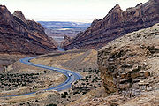
While co-routed with I-70, US-50 crosses the Wasatch Plateau and passes through the San Rafael Swell
. The construction of I-70 through the swell is noted as one of the engineering marvels of the Interstate Highway System
. One specific feat, the excavation through a portion called Spotted Wolf Canyon, required excavating 3500000 cubic yards (2,675,942 m³) of rock to have a bed for just 8 miles (12.9 km) of roadway. Construction workers noted that prior to the construction of the freeway a man could stand in this canyon and touch both sides of the canyon wall.
US-6 rejoins US-50 near Green River
. The three routes run concurrent and follow the southern edge of the Book Cliffs
to Grand Junction, Colorado
. Once again, services are not present from Thompson Springs
to Fruita, Colorado
, a span of about 60 miles (96.6 km). This portion of US-50 is part of the Dinosaur Diamond Prehistoric Highway, a National Scenic Byway
. The name of the byway comes from the large number of areas along the route with visible dinosaur remains.
and Green River, Utah
is the third iteration.
. At the time the states of Utah and Nevada were feuding about which of the old auto trail
s would be paved and used for the new U.S. Highway System. Nevada favored the Lincoln Highway
, which the modern US-50 closely follows in that state. Utah refused to consider the Lincoln Highway west of Salt Lake City
. Officials perceived that route would carry all California bound traffic directly to Nevada while passing through very few communities in Utah. Utah instead favored the Victory Highway
(modern Interstate 80
west of Salt Lake) and the Arrowhead Trail (modern Interstate 15
). By favoring these routes Utah could force travelers destined for southern California to use a different route than those destined for northern California, with both of these traversing through more cities in Utah than the Lincoln Highway. The Arrowhead trail was especially beneficial to Utah as it passed through many communities in the state, but only Las Vegas
in Nevada.
Utah prevailed and US-50 did not continue to follow the Lincoln Highway to Salt Lake City as Nevada had wanted. The first continuous route of US-50 across eastern Nevada and western Utah was an arch shaped route. US-50 proceeded north from Ely along what is now numbered U.S. Route 93 and Alternate US-93
where the highway would merge with the Victory Highway (U.S. Route 40
, since replaced by I-80) to Salt Lake. From there the highway returned to Green River via what is now numbered State Route 201, U.S. Route 89 and U.S. Route 6.
to Long Beach, California
. In eastern Utah the route used the existing alignment of US-50. However, in western Utah the route used an unpaved road through Delta reconnecting with US-50 in Ely. By 1954, this route was fully paved and US-50 was moved to this shorter alignment. With this change US-6/50 ran concurrent from Ely to Grand Junction, Colorado
.
The paved version did not exactly follow the unpaved roads. The dirt route passed through the numerous mountain ranges of the great basin with the most difficult being Marjum Canyon. The route was relocated to follow the north shore of Sevier Lake
, which reduced the number of mountain ranges crossed. Although US-50 was moved to yet another alignment, this route remains US-6 today.
. While I-70 was in the planning stage Colorado lobbied for an extension of the original proposal to run across Colorado and into Utah. Utah supported an extension using then US-6/50 to connect Denver, Colorado
with Salt Lake City. However, federal planners did not see value in this route and instead supported a route that could be used to connect Denver with Los Angeles, California
. I-70 was built using the federally selected route. In 1976, US-50 was changed again to a routing mostly concurrent with I-70. The portion of modern US-50 between Delta and Scipio
had been previously numbered State Route 26, and the portion between Scipio and Salina had been numbered State Route 63, with the SR-63 portion being transferred to SR-26 in 1971.
East of Green River I-70 closely follows the original route of US-50, with some minor straightening by Crescent Junction, Cisco
, and Westwater.
U.S. Route 50
U.S. Route 50 is a major east–west route of the U.S. Highway system, stretching just over from Ocean City, Maryland on the Atlantic Ocean to West Sacramento, California. Until 1972, when it was replaced by Interstate Highways west of the Sacramento area, it extended to San Francisco, near...
, commonly abbreviated US-50, crosses the center of the state. The highway serves no major population centers in Utah, with the largest city along its path being Delta
Delta, Utah
Delta is a city in Millard County, Utah, United States. The population was 3,209 at the 2000 census.-Geography:Delta is located at ....
. Most of the route passes through desolate, remote areas. Through the eastern half of the state the route is concurrent
Concurrency (road)
A concurrency, overlap, or coincidence in a road network is an instance of one physical road bearing two or more different highway, motorway, or other route numbers...
with Interstate 70
Interstate 70 in Utah
Interstate 70 is a mainline route of the Interstate Highway System in the United States connecting Utah and Maryland. The Utah section runs east–west for across the central part of the state. Richfield is the largest Utah city served by the freeway, which does not serve or connect any urban areas...
. US-50 both enters and exits Utah concurrent with U.S. Route 6, however the two routes are separate through the center of the state.
Three completely different routings of US-50 have existed between Green River
Green River, Utah
Green River is a city in Emery County, Utah, United States. The population was 973 at the 2000 census.-Geography:Green River is located at , on the banks of the Green River, after which the city is named. The San Rafael Swell region is to the west of Green River, while Canyonlands National Park...
and Ely, Nevada
Ely, Nevada
Ely is the largest city and county seat of White Pine County, Nevada, United States. Ely was founded as a stagecoach station along the Pony Express and Central Overland Route. Ely's mining boom came later than the other towns along US 50, with the discovery of copper in 1906...
. The route between these cities has become progressively shorter as new roads have been paved through this largely uninhabited region of both states. The earlier routings were a result of a dispute between Utah and Nevada over which auto trail
Auto trail
The system of auto trails was an informal network of marked routes that existed in the United States and Canada in the early part of the 20th century. Marked with colored bands on telephone poles, the trails were intended to help travellers in the early days of the automobile.Auto trails were...
s would be paved and converted to U.S. Highways.
Route description
Great Basin
The Great Basin is the largest area of contiguous endorheic watersheds in North America and is noted for its arid conditions and Basin and Range topography that varies from the North American low point at Badwater Basin to the highest point of the contiguous United States, less than away at the...
desert. Similar to many portions of the route in Nevada
U.S. Route 50 in Nevada
U.S. Route 50 is a transcontinental highway in the United States, stretching from Sacramento, California in the west to Ocean City, Maryland on the east coast. The Nevada portion crosses the center of state and was named The Loneliest Road in America by Life magazine in July 1986...
, there are no services from this point to Delta
Delta, Utah
Delta is a city in Millard County, Utah, United States. The population was 3,209 at the 2000 census.-Geography:Delta is located at ....
, a span of roadway that is about 100 miles (160.9 km). While passing through the Great Basin the highway crosses two mountain ranges, the Confusion Range via kings canyon and House Range via Skull Rock Pass, before arriving at the shore of Sevier Lake
Sevier Lake
Sevier Lake is an intermittent and endorheic lake which lies in the lowest part of the Sevier Desert, Millard County, Utah. Like Great Salt Lake and Utah Lake, it is a remnant of Pleistocene Lake Bonneville. Sevier Lake is fed primarily by the Beaver and Sevier rivers, and the additional inflow...
. Sevier Lake is an intermittent lake which is fed by snow melt from many mountain ranges in the eastern half of the Great Basin. From US-50, water is only usually visible in the spring months. The highway follows Sevier Lake to Delta
Delta, Utah
Delta is a city in Millard County, Utah, United States. The population was 3,209 at the 2000 census.-Geography:Delta is located at ....
.
The scenery dramatically changes as US-50 approaches Delta, where U.S. Route 6 and 50 separate. As the road approaches Delta, a straight passage across desert changes to zigzag
Zigzag
A zigzag is a pattern made up of small corners at variable angles, though constant within the zigzag, tracing a path between two parallel lines; it can be described as both jagged and fairly regular....
s through farming areas. The highway continues to zigzag through farms until arriving at more mountainous terrain at Holden
Holden, Utah
Holden is a town in Millard County, Utah, United States. The population was 400 at the 2000 census.-History:Holden was settled in 1855 by a group of ten families sent out by the LDS bishop of Fillmore. It was named for Elijah E...
. At Holden, the highway merges with Interstate 15
Interstate 15 in Utah
In the U.S. state of Utah, Interstate 15 runs north–south through the southwestern and central portions of the state, passing through many of the population centers of that state, including St. George, Provo, Salt Lake City, and Ogden, the latter three being part of the urban area known as...
to cross the Pavant Range
Pavant Range
The Pavant Range is a mountain range in central Utah east of Fillmore. The range is named for the Pahvant tribe, a branch of the Ute Indians. The tallest peak is Mine Camp Peak at . Most of the land in the Pavant range is part of Fishlake National Forest.-Transportation:The mountain range is...
at Scipio
Scipio, Utah
Scipio is a town in Millard County, Utah, United States. The population was 290 at the 2000 census.-Geography:Scipio is located at ....
Summit. US-50 then separates from this freeway to meet Interstate 70
Interstate 70 in Utah
Interstate 70 is a mainline route of the Interstate Highway System in the United States connecting Utah and Maryland. The Utah section runs east–west for across the central part of the state. Richfield is the largest Utah city served by the freeway, which does not serve or connect any urban areas...
in Salina
Salina, Utah
Salina is a city in Sevier County, Utah, United States. The population was 2,393 at the 2000 census.-History:The first permanent settlers moved into the area in 1864 at the direction of leaders of the Church of Jesus Christ of Latter-day Saints...
. The two highways run concurrent from this point east to Colorado
Colorado
Colorado is a U.S. state that encompasses much of the Rocky Mountains as well as the northeastern portion of the Colorado Plateau and the western edge of the Great Plains...
. Yet again, there is a stretch of highway 110 miles (177 km) long without services from Salina to Green River
Green River, Utah
Green River is a city in Emery County, Utah, United States. The population was 973 at the 2000 census.-Geography:Green River is located at , on the banks of the Green River, after which the city is named. The San Rafael Swell region is to the west of Green River, while Canyonlands National Park...
.
While co-routed with I-70, US-50 crosses the Wasatch Plateau and passes through the San Rafael Swell
San Rafael Swell
The San Rafael Swell is a large geologic feature located in south-central Utah, USA about 30 miles west of Green River, Utah. The San Rafael Swell, approximately by , consists of a giant dome-shaped anticline of sandstone, shale, and limestone that was pushed up during the Paleocene Laramide...
. The construction of I-70 through the swell is noted as one of the engineering marvels of the Interstate Highway System
Interstate Highway System
The Dwight D. Eisenhower National System of Interstate and Defense Highways, , is a network of limited-access roads including freeways, highways, and expressways forming part of the National Highway System of the United States of America...
. One specific feat, the excavation through a portion called Spotted Wolf Canyon, required excavating 3500000 cubic yards (2,675,942 m³) of rock to have a bed for just 8 miles (12.9 km) of roadway. Construction workers noted that prior to the construction of the freeway a man could stand in this canyon and touch both sides of the canyon wall.
US-6 rejoins US-50 near Green River
Green River, Utah
Green River is a city in Emery County, Utah, United States. The population was 973 at the 2000 census.-Geography:Green River is located at , on the banks of the Green River, after which the city is named. The San Rafael Swell region is to the west of Green River, while Canyonlands National Park...
. The three routes run concurrent and follow the southern edge of the Book Cliffs
Book Cliffs
The Book Cliffs are a series of mountains and cliffs in western Colorado and eastern Utah, in the western United States. They are so named because many of them have the triangular appearance of a book that has been opened up, then turned on its sides and set to rest on the open sides of the book,...
to Grand Junction, Colorado
Grand Junction, Colorado
The City of Grand Junction is the largest city in western Colorado. It is a city with a council–manager government form that is the county seat and the most populous city of Mesa County, Colorado, United States. Grand Junction is situated west-southwest of the Colorado State Capitol in Denver. As...
. Once again, services are not present from Thompson Springs
Thompson Springs, Utah
Thompson Springs, also known as Thompson, is a small census-designated place in central Grand County, Utah, United States. The population was 39 at the 2010 census. The town is just north of the east-west highway route shared by Interstate 70, U.S. Route 6 and U.S. Route 50, between Crescent...
to Fruita, Colorado
Fruita, Colorado
The City of Fruita is a Home Rule Municipality located in the western part of Mesa County, Colorado, in the United States. It is part of the Grand Junction Metropolitan Statistical Area and within the Grand Valley...
, a span of about 60 miles (96.6 km). This portion of US-50 is part of the Dinosaur Diamond Prehistoric Highway, a National Scenic Byway
National Scenic Byway
A National Scenic Byway is a road recognized by the United States Department of Transportation for its archeological, cultural, historic, natural, recreational, and/or scenic qualities. The program was established by Congress in 1991 to preserve and protect the nation's scenic but often...
. The name of the byway comes from the large number of areas along the route with visible dinosaur remains.
History
The modern route of U.S. Route 50 between Ely, NevadaEly, Nevada
Ely is the largest city and county seat of White Pine County, Nevada, United States. Ely was founded as a stagecoach station along the Pony Express and Central Overland Route. Ely's mining boom came later than the other towns along US 50, with the discovery of copper in 1906...
and Green River, Utah
Green River, Utah
Green River is a city in Emery County, Utah, United States. The population was 973 at the 2000 census.-Geography:Green River is located at , on the banks of the Green River, after which the city is named. The San Rafael Swell region is to the west of Green River, while Canyonlands National Park...
is the third iteration.
First iteration
In 1926, when the U.S. Highway system was first announced, there was a gap in US-50 between Ely and ThistleThistle, Utah
Thistle is a ghost town in Utah County, Utah, United States, about southeast of Salt Lake City. During the era of steam locomotives, the town's primary industry was servicing trains for the Denver and Rio Grande Western Railroad...
. At the time the states of Utah and Nevada were feuding about which of the old auto trail
Auto trail
The system of auto trails was an informal network of marked routes that existed in the United States and Canada in the early part of the 20th century. Marked with colored bands on telephone poles, the trails were intended to help travellers in the early days of the automobile.Auto trails were...
s would be paved and used for the new U.S. Highway System. Nevada favored the Lincoln Highway
Lincoln Highway
The Lincoln Highway was the first road across the United States of America.Conceived and promoted by entrepreneur Carl G. Fisher, the Lincoln Highway spanned coast-to-coast from Times Square in New York City to Lincoln Park in San Francisco, originally through 13 states: New York, New Jersey,...
, which the modern US-50 closely follows in that state. Utah refused to consider the Lincoln Highway west of Salt Lake City
Salt Lake City, Utah
Salt Lake City is the capital and the most populous city of the U.S. state of Utah. The name of the city is often shortened to Salt Lake or SLC. With a population of 186,440 as of the 2010 Census, the city lies in the Salt Lake City metropolitan area, which has a total population of 1,124,197...
. Officials perceived that route would carry all California bound traffic directly to Nevada while passing through very few communities in Utah. Utah instead favored the Victory Highway
Victory Highway
The Victory Highway was an auto trail across the United States between New York City and San Francisco, roughly equivalent to the present U.S. Route 40.-History:...
(modern Interstate 80
Interstate 80
Interstate 80 is the second-longest Interstate Highway in the United States, following Interstate 90. It is a transcontinental artery running from downtown San Francisco, California to Teaneck, New Jersey in the New York City Metropolitan Area...
west of Salt Lake) and the Arrowhead Trail (modern Interstate 15
Interstate 15 in Utah
In the U.S. state of Utah, Interstate 15 runs north–south through the southwestern and central portions of the state, passing through many of the population centers of that state, including St. George, Provo, Salt Lake City, and Ogden, the latter three being part of the urban area known as...
). By favoring these routes Utah could force travelers destined for southern California to use a different route than those destined for northern California, with both of these traversing through more cities in Utah than the Lincoln Highway. The Arrowhead trail was especially beneficial to Utah as it passed through many communities in the state, but only Las Vegas
Las Vegas, Nevada
Las Vegas is the most populous city in the U.S. state of Nevada and is also the county seat of Clark County, Nevada. Las Vegas is an internationally renowned major resort city for gambling, shopping, and fine dining. The city bills itself as The Entertainment Capital of the World, and is famous...
in Nevada.
Utah prevailed and US-50 did not continue to follow the Lincoln Highway to Salt Lake City as Nevada had wanted. The first continuous route of US-50 across eastern Nevada and western Utah was an arch shaped route. US-50 proceeded north from Ely along what is now numbered U.S. Route 93 and Alternate US-93
U.S. Route 93 Alternate (Nevada)
In the U.S. state of Nevada, U.S. Route 93 Alternate is an alternate route of U.S. Route 93 located in the northeast part of the state. It connects Lages Station to Wells via the town of West Wendover....
where the highway would merge with the Victory Highway (U.S. Route 40
U.S. Route 40
U.S. Route 40 is an east–west United States highway. As with most routes whose numbers end in a zero, U.S. 40 once traversed the entire United States. It is one of the original 1920s U.S. Highways, and its first termini were San Francisco, California, and Atlantic City, New Jersey...
, since replaced by I-80) to Salt Lake. From there the highway returned to Green River via what is now numbered State Route 201, U.S. Route 89 and U.S. Route 6.
Second iteration
The second iteration has its origins with the formation of US-6. In 1937, US-6 was extended west from its former terminus at Greeley, ColoradoGreeley, Colorado
The City of Greeley is a Home Rule Municipality that is the county seat and the most populous city of Weld County, Colorado, United States. Greeley is located in the region known as Northern Colorado. Greeley is situated north-northeast of the Colorado State Capitol in Denver. According to the...
to Long Beach, California
Long Beach, California
Long Beach is a city situated in Los Angeles County in Southern California, on the Pacific coast of the United States. The city is the 36th-largest city in the nation and the seventh-largest in California. As of 2010, its population was 462,257...
. In eastern Utah the route used the existing alignment of US-50. However, in western Utah the route used an unpaved road through Delta reconnecting with US-50 in Ely. By 1954, this route was fully paved and US-50 was moved to this shorter alignment. With this change US-6/50 ran concurrent from Ely to Grand Junction, Colorado
Grand Junction, Colorado
The City of Grand Junction is the largest city in western Colorado. It is a city with a council–manager government form that is the county seat and the most populous city of Mesa County, Colorado, United States. Grand Junction is situated west-southwest of the Colorado State Capitol in Denver. As...
.
The paved version did not exactly follow the unpaved roads. The dirt route passed through the numerous mountain ranges of the great basin with the most difficult being Marjum Canyon. The route was relocated to follow the north shore of Sevier Lake
Sevier Lake
Sevier Lake is an intermittent and endorheic lake which lies in the lowest part of the Sevier Desert, Millard County, Utah. Like Great Salt Lake and Utah Lake, it is a remnant of Pleistocene Lake Bonneville. Sevier Lake is fed primarily by the Beaver and Sevier rivers, and the additional inflow...
, which reduced the number of mountain ranges crossed. Although US-50 was moved to yet another alignment, this route remains US-6 today.
Third iteration
The modern route of US-50 was created in 1976. This iteration of US-50 has its origins in a dispute over the route of Interstate 70 in UtahInterstate 70 in Utah
Interstate 70 is a mainline route of the Interstate Highway System in the United States connecting Utah and Maryland. The Utah section runs east–west for across the central part of the state. Richfield is the largest Utah city served by the freeway, which does not serve or connect any urban areas...
. While I-70 was in the planning stage Colorado lobbied for an extension of the original proposal to run across Colorado and into Utah. Utah supported an extension using then US-6/50 to connect Denver, Colorado
Denver, Colorado
The City and County of Denver is the capital and the most populous city of the U.S. state of Colorado. Denver is a consolidated city-county, located in the South Platte River Valley on the western edge of the High Plains just east of the Front Range of the Rocky Mountains...
with Salt Lake City. However, federal planners did not see value in this route and instead supported a route that could be used to connect Denver with Los Angeles, California
Los Angeles, California
Los Angeles , with a population at the 2010 United States Census of 3,792,621, is the most populous city in California, USA and the second most populous in the United States, after New York City. It has an area of , and is located in Southern California...
. I-70 was built using the federally selected route. In 1976, US-50 was changed again to a routing mostly concurrent with I-70. The portion of modern US-50 between Delta and Scipio
Scipio, Utah
Scipio is a town in Millard County, Utah, United States. The population was 290 at the 2000 census.-Geography:Scipio is located at ....
had been previously numbered State Route 26, and the portion between Scipio and Salina had been numbered State Route 63, with the SR-63 portion being transferred to SR-26 in 1971.
East of Green River I-70 closely follows the original route of US-50, with some minor straightening by Crescent Junction, Cisco
Cisco, Utah
Cisco is a ghost town in Grand County, Utah near the junction of State Route 128 and Interstate 70. At one time the town served as a saloon and water-refilling station for the Denver and Rio Grande Western Railroad. The town's demise came with the demise of the steam locomotive. The town site...
, and Westwater.
Major intersections
| County | Location | Mile | # Exit number An exit number is a number assigned to a road junction, usually an exit from a freeway. It is usually marked on the same sign as the destinations of the exit, as well as a sign in the gore.... |
Junction | Notes |
|---|---|---|---|---|---|
| Millard Millard County, Utah Millard County is a county located in the U.S. state of Utah. In 2010, its population was 12,420. It was named for Millard Fillmore, thirteenth President of the United States. Its county seat is Fillmore and the largest city is Delta.-Geography:... |
0.000 | Nevada state line | |||
| 0.665 | |||||
| 83.897 | |||||
| Delta Delta, Utah Delta is a city in Millard County, Utah, United States. The population was 3,209 at the 2000 census.-Geography:Delta is located at .... |
89.402 | East end of overlap with US-6 | |||
| 92.976 | |||||
| 107.597 | |||||
| Holden Holden, Utah Holden is a town in Millard County, Utah, United States. The population was 400 at the 2000 census.-History:Holden was settled in 1855 by a group of ten families sent out by the LDS bishop of Fillmore. It was named for Elijah E... |
116.497 |    .svg.png) SR-64 SR-64Utah State Route 64 State Route 64 is a state highway in the U.S. state of Utah that serves as a connection from US-50 in the town of Holden to I-15, which bypasses the town... to I-15 Interstate 15 in Utah In the U.S. state of Utah, Interstate 15 runs north–south through the southwestern and central portions of the state, passing through many of the population centers of that state, including St. George, Provo, Salt Lake City, and Ogden, the latter three being part of the urban area known as... south |
Former US-91 south | ||
| 119.723 | West end of overlap with I-15 | ||||
| 129.816 | East end of overlap with I-15 | ||||
| Sevier Sevier County, Utah As of the census of 2000, there were 18,842 people, 6,081 households, and 4,907 families residing in the county. The population density was 10 people per square mile . There were 7,016 housing units at an average density of 4 per square mile... |
154.805 |  .svg.png) SR-260 SR-260Utah State Route 260 State Route 260 is a highway within Sevier County in central Utah that connects SR-24 to US-50 while passing through the town of Aurora in a span of four miles .-Route description:... south to I-70 Interstate 70 in Utah Interstate 70 is a mainline route of the Interstate Highway System in the United States connecting Utah and Maryland. The Utah section runs east–west for across the central part of the state. Richfield is the largest Utah city served by the freeway, which does not serve or connect any urban areas... west – Aurora Aurora, Utah Aurora is a city in Sevier County, Utah, United States. The population was 947 at the 2000 census.Aurora is predominantly supported by agriculture, coal mining, and the service sector. Most residents commute to one of the neighboring communities to work. Children are schooled in Salina at one of... |
|||
| Salina Salina, Utah Salina is a city in Sevier County, Utah, United States. The population was 2,393 at the 2000 census.-History:The first permanent settlers moved into the area in 1864 at the direction of leaders of the Church of Jesus Christ of Latter-day Saints... |
157.803 | ||||
| 158.527 | West end of overlap with I-70 Bus./US-89 | ||||
| 160.282 | East end of overlap with I-70 Bus./US-89; west end of overlap with I-70 | ||||
| 190.350 | 86 | Ivie Creek Rest Area (SR-76 Utah State Route 76 State Route 76 is a state highway in the U.S. state of Utah that serves as a connector from I-70 to SR-72 at Fremont Junction. This road was given the SR-76 designation in 1977, coinciding with the construction of I-70 through the area... ) |
Connects eastbound traffic to SR-72 | ||
| 194.588 | 91 | ||||
| Emery Emery County, Utah Emery County is a county located in the U.S. state of Utah. As of 2000 the population was 10,860, and by 2009 had been estimated to decrease to 10,629. It was named for George W. Emery, governor of the Utah Territory in 1875... |
252.775 | 149 | |||
| 271.501 | 157 | , Salt Lake | West end of overlap with US-6/US-191 | ||
| 273.980 | 160 | Former route of US-50 east | |||
| Grand Grand County, Utah Grand County is a county located in the U.S. state of Utah. As of 2000 the population was 8,485, and by 2005 had been estimated at 8,743. It was named for the Colorado River, which at the time of statehood was known as the Grand River. Its county seat and largest city is Moab.-Geography:According... |
278.124 | 164 | |||
| 285.730 | 182 | East end of overlap with US-191 | |||
| 290.990 | 187 | Thompson Springs Thompson Springs, Utah Thompson Springs, also known as Thompson, is a small census-designated place in central Grand County, Utah, United States. The population was 39 at the 2010 census. The town is just north of the east-west highway route shared by Interstate 70, U.S. Route 6 and U.S. Route 50, between Crescent... (SR-94 Utah State Route 94 State Route 94 , located entirely within Grand County, is a long state highway in the U.S. state of Utah. The highway serves as a spur route into Thompson Springs... ) |
|||
| 318.315 | 204 | ||||
| 334.920 | Colorado state line | ||||