
Utah State Route 94
Encyclopedia
State Route 94 located entirely within Grand County
, is a 0.958 miles (1.5 km) long state highway
in the U.S. state
of Utah
. The highway serves as a spur route
into Thompson Springs
. The highway was formed in 1969, at the same time Interstate 70
(I-70) was constructed through the area.
 Located entirely in Grand County
's Thompson Springs
, SR-94 begins at a diamond interchange
with exit 187 of I-70
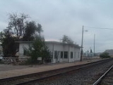
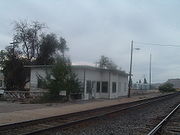
and heads north as a two–lane undivided highway. The road turns to the northeast after intersecting a local road, passing the Utah Department of Transportation
maintenance facility east of the highway. After the maintenance facility the route turns north again and passes a mobile home court and comes to an end at an intersection with Old Highway Cisco. Across Old Highway Cisco is a former railroad depot of the Denver and Rio Grande Western Railroad
.
For the year 2007, a daily average of 750 cars traveled along SR-94, representing only a slight growth from previous years (in 2006, the average was 745; in 2005, 685). Fifty three percent of this traffic was composed of trucks. The average traffic measurement is collected at the interchange with I-70.
Grand County, Utah
Grand County is a county located in the U.S. state of Utah. As of 2000 the population was 8,485, and by 2005 had been estimated at 8,743. It was named for the Colorado River, which at the time of statehood was known as the Grand River. Its county seat and largest city is Moab.-Geography:According...
, is a 0.958 miles (1.5 km) long state highway
State highway
State highway, state road or state route can refer to one of three related concepts, two of them related to a state or provincial government in a country that is divided into states or provinces :#A...
in the U.S. state
U.S. state
A U.S. state is any one of the 50 federated states of the United States of America that share sovereignty with the federal government. Because of this shared sovereignty, an American is a citizen both of the federal entity and of his or her state of domicile. Four states use the official title of...
of Utah
Utah
Utah is a state in the Western United States. It was the 45th state to join the Union, on January 4, 1896. Approximately 80% of Utah's 2,763,885 people live along the Wasatch Front, centering on Salt Lake City. This leaves vast expanses of the state nearly uninhabited, making the population the...
. The highway serves as a spur route
Spur route
A spur route is a short road forming a branch from a longer, more important route . A bypass or beltway is never considered a true spur route as it typically reconnects with the major road...
into Thompson Springs
Thompson Springs, Utah
Thompson Springs, also known as Thompson, is a small census-designated place in central Grand County, Utah, United States. The population was 39 at the 2010 census. The town is just north of the east-west highway route shared by Interstate 70, U.S. Route 6 and U.S. Route 50, between Crescent...
. The highway was formed in 1969, at the same time Interstate 70
Interstate 70 in Utah
Interstate 70 is a mainline route of the Interstate Highway System in the United States connecting Utah and Maryland. The Utah section runs east–west for across the central part of the state. Richfield is the largest Utah city served by the freeway, which does not serve or connect any urban areas...
(I-70) was constructed through the area.
Route description
Grand County, Utah
Grand County is a county located in the U.S. state of Utah. As of 2000 the population was 8,485, and by 2005 had been estimated at 8,743. It was named for the Colorado River, which at the time of statehood was known as the Grand River. Its county seat and largest city is Moab.-Geography:According...
's Thompson Springs
Thompson Springs, Utah
Thompson Springs, also known as Thompson, is a small census-designated place in central Grand County, Utah, United States. The population was 39 at the 2010 census. The town is just north of the east-west highway route shared by Interstate 70, U.S. Route 6 and U.S. Route 50, between Crescent...
, SR-94 begins at a diamond interchange
Diamond interchange
A diamond interchange is a common type of road junction, used where a freeway crosses a minor road. The freeway itself is grade-separated from the minor road, one crossing the other over a bridge...
with exit 187 of I-70
Interstate 70 in Utah
Interstate 70 is a mainline route of the Interstate Highway System in the United States connecting Utah and Maryland. The Utah section runs east–west for across the central part of the state. Richfield is the largest Utah city served by the freeway, which does not serve or connect any urban areas...
and heads north as a two–lane undivided highway. The road turns to the northeast after intersecting a local road, passing the Utah Department of Transportation
Utah Department of Transportation
The Utah Department of Transportation is an agency of the state government for the U.S. state of Utah. The agency is usually referred to by its initials UDOT . UDOT is charged with maintaining the network of state highways in Utah. The agency is headquartered in the Calvin L. Rampton state office...
maintenance facility east of the highway. After the maintenance facility the route turns north again and passes a mobile home court and comes to an end at an intersection with Old Highway Cisco. Across Old Highway Cisco is a former railroad depot of the Denver and Rio Grande Western Railroad
Denver and Rio Grande Western Railroad
The Denver & Rio Grande Western Railroad , often shortened to Rio Grande or D&RGW, formerly the Denver & Rio Grande Railroad, is a defunct U.S. railroad company. The railroad started as a narrow gauge line running south from Denver, Colorado in 1870; however, served mainly as a transcontinental...
.
For the year 2007, a daily average of 750 cars traveled along SR-94, representing only a slight growth from previous years (in 2006, the average was 745; in 2005, 685). Fifty three percent of this traffic was composed of trucks. The average traffic measurement is collected at the interchange with I-70.
History
State Route 94 was formed in 1969 as a connector from I-70 to Thompson Springs. When I-70 was constructed through the area, it bypassed the town, creating a need for a connector road. The northern terminus of the route is old US-6/US-50.Major intersections
| Mile | Destinations | Notes |
|---|---|---|
| 0.000 | Southern terminus | |
| 0.958 | Old Highway Cisco | Northern terminus |