

Tunnels in New Zealand
Encyclopedia
Road
A road is a thoroughfare, route, or way on land between two places, which typically has been paved or otherwise improved to allow travel by some conveyance, including a horse, cart, or motor vehicle. Roads consist of one, or sometimes two, roadways each with one or more lanes and also any...
and waterway
Waterway
A waterway is any navigable body of water. Waterways can include rivers, lakes, seas, oceans, and canals. In order for a waterway to be navigable, it must meet several criteria:...
tunnel
Tunnel
A tunnel is an underground passageway, completely enclosed except for openings for egress, commonly at each end.A tunnel may be for foot or vehicular road traffic, for rail traffic, or for a canal. Some tunnels are aqueducts to supply water for consumption or for hydroelectric stations or are sewers...
s, including hydroelectric intake
Intake
An intake , or especially for aircraft inlet, is an air intake for an engine. Because the modern internal combustion engine is in essence a powerful air pump, like the exhaust system on an engine, the intake must be carefully engineered and tuned to provide the greatest efficiency and power...
s and tailraces and gun battery
Artillery battery
In military organizations, an artillery battery is a unit of guns, mortars, rockets or missiles so grouped in order to facilitate better battlefield communication and command and control, as well as to provide dispersion for its constituent gunnery crews and their systems...
tunnels. It includes artificial chamber
Chamber
Chamber may refer to:*Chamber , a Marvel Comics superhero associated with the X-Men*Chamber , the portion of the barrel or firing cylinder in which the cartridge is inserted prior to being fired...
s but excludes New Zealand caves and New Zealand mines
Mining in New Zealand
Mining in New Zealand began when the indigenous Māori quarried rock such as argillite in times prior to European colonisation. Mining by Europeans began in the latter half of the 19th century....
.
For hydroelectric usage
- Manapouri Power Station - Machine hall 111 m long, 18 m wide, 34 m high, and road access tunnel 2040 m long, 6.7 m wide and high, with a semi-circular arch roof.
- Manapouri TailraceManapouri Power StationManapouri Power Station is an underground hydroelectric power station on the western arm of Lake Manapouri in Fiordland National Park, in the South Island of New Zealand...
- 2 tunnels - original tailrace tunnel 9817 m long, 9.2 m diameter horseshoe section, commenced 1964, breakthrough 1968 drill-and-blast construction, 16 deaths. Second tailrace tunnel 9829 m long, 10.05 m diameter, circular section, commenced 1997, breakthrough 2001, commissioned April 2002, tunnel boring machineTunnel boring machineA tunnel boring machine also known as a "mole", is a machine used to excavate tunnels with a circular cross section through a variety of soil and rock strata. They can bore through anything from hard rock to sand. Tunnel diameters can range from a metre to almost 16 metres to date...
construction, 0 deaths. - Tongariro Power SchemeTongariro Power SchemeThe Tongariro Power Scheme is a 360 MW hydroelectricity scheme in the central North Island of New Zealand. The scheme is currently operated by state-owned electricity generation company Genesis Energy....
For military usage
- DevonportDevonport, New ZealandDevonport is a harbourside suburb of Auckland, New Zealand. It is located on the North Shore, at the southern end of a peninsula that runs southeast from near Lake Pupuke in Takapuna, forming the northern side of the Waitemata Harbour...
Tunnels, AucklandAucklandThe Auckland metropolitan area , in the North Island of New Zealand, is the largest and most populous urban area in the country with residents, percent of the country's population. Auckland also has the largest Polynesian population of any city in the world... - Whangaparaoa Navy Camp, two sets of tunnels, AucklandAucklandThe Auckland metropolitan area , in the North Island of New Zealand, is the largest and most populous urban area in the country with residents, percent of the country's population. Auckland also has the largest Polynesian population of any city in the world...
- Stony BatterStony BatterStony Batter is a historic defence installation at the northeastern end of Waiheke Island, Auckland, New Zealand. It is sited within a 50 acre scenic reserve of the same name, owned by the New Zealand Department of Conservation...
, Waiheke IslandWaiheke IslandWaiheke Island is an island in the Hauraki Gulf of New Zealand, located about from Auckland.The island is the second-largest in the Hauraki Gulf after Great Barrier Island. It is the most populated, with nearly 8,000 permanent residents plus another estimated 3,400 who have second or holiday homes... - Wrights Hill FortressWrights Hill FortressWrights Hill Fortress is a counter bombardment coastal artillery battery in the Karori suburb of Wellington, New Zealand. It was built between 1942 and 1947 and is predominantly underground, with numerous tunnels linking the war shelters, gun emplacements, magazines, plotting rooms and engine room...
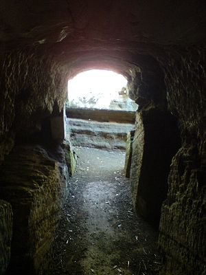
, WellingtonWellingtonWellington is the capital city and third most populous urban area of New Zealand, although it is likely to have surpassed Christchurch due to the exodus following the Canterbury Earthquake. It is at the southwestern tip of the North Island, between Cook Strait and the Rimutaka Range... - Cracroft CavernsCracroft CavernsCracroft Caverns, also known as the Cashmere Caverns, are a series of large chambers in the hill of the Cashmere suburb of Christchurch, New Zealand....
- Chamber, ChristchurchChristchurchChristchurch is the largest city in the South Island of New Zealand, and the country's second-largest urban area after Auckland. It lies one third of the way down the South Island's east coast, just north of Banks Peninsula which itself, since 2006, lies within the formal limits of... - Godley Head, ChristchurchChristchurchChristchurch is the largest city in the South Island of New Zealand, and the country's second-largest urban area after Auckland. It lies one third of the way down the South Island's east coast, just north of Banks Peninsula which itself, since 2006, lies within the formal limits of...
- Cashin Quay - Extensive network in midway hillside, LytteltonLyttelton, New ZealandLyttelton is a port town on the north shore of Lyttelton Harbour close to Banks Peninsula, a suburb of Christchurch on the eastern coast of the South Island of New Zealand....
- Taiaroa HeadTaiaroa HeadTaiaroa Head is a headland at the end of the Otago Peninsula in New Zealand, overlooking the mouth of the Otago Harbour. It lies within the city limits of Dunedin...
and Harington Point, Dunedin
For air raid shelters
- Albert Park tunnelsAlbert Park tunnelsThe Albert Park tunnels are found largely beneath Albert Park, in central Auckland, New Zealand. The tunnels were constructed as air raid shelters during the Second World War...
, built to shelter civilians in the event of an air raid
For rail transport
Longest Bored TunnelsFrom longest to shortest.
- KaimaiKaimai TunnelThe Kaimai Tunnel is a railway tunnel through the Kaimai Range in the North Island of New Zealand. Since it was opened in 1978, it has held the title of longest tunnel in New Zealand, assuming this distinction from the previous title holder, the Rimutaka Tunnel...
- 8879 m - opened 12 September 1978 - near Apata on the East Coast Main Trunk Railway Line to TaurangaTaurangaTauranga is the most populous city in the Bay of Plenty region, in the North Island of New Zealand.It was settled by Europeans in the early 19th century and was constituted as a city in 1963...
, the longest rail tunnel in New Zealand. - RimutakaRimutaka TunnelThe Rimutaka Tunnel is a railway tunnel through New Zealand's Rimutaka Ranges, between Maymorn, near Upper Hutt, and Featherston, on the Wairarapa Line.The tunnel, which was opened to traffic on 3 November 1955, is long...
- 8798 m - opened 3 November 1955 - between Upper Hutt (Wellington) and FeatherstonFeatherston, New ZealandFeatherston is a town in the north of the Wellington Region region of New Zealand. It lies in the Wairarapa, just north of the Rimutaka Tunnel, in the South Wairarapa District. The population was 2,340 in the 2006 Census....
(WairarapaWairarapaWairarapa is a geographical region of New Zealand. It occupies the south-eastern corner of the North Island, east of metropolitan Wellington and south-west of the Hawke's Bay region. It is lightly populated, having several rural service towns, with Masterton being the largest...
), replaced the Rimutaka Incline, a FellFell mountain railway systemThe Fell system uses a raised centre rail between the two running rails on steeply-graded railway lines to provide extra traction and braking, or braking alone. Trains are propelled by wheels or braked by shoes pressed horizontally onto the centre rail, as well as by means of the normal running...
mountain railwayMountain railwayA mountain railway is a railway that ascends and descends a mountain slope that has a steep grade. Such railways can use a number of different technologies to overcome the steepness of the grade...
, the longest tunnel in New Zealand that carries regular passenger trains. - OtiraOtira TunnelThe Otira Tunnel is a railway tunnel on the Midland Line in the South Island of New Zealand between Otira and Arthur's Pass. It runs under the Southern Alps from Arthur's Pass to Otira - a length of over . The gradient is mainly 1 in 33, and the Otira end of the tunnel is over lower than the...
- 8566 m - opened 1923 - between Arthur's PassArthur's PassArthur's Pass is a mountain pass in the Southern Alps of the South Island of New Zealand. It marks part of the boundary between the West Coast and Canterbury regions, 140 km from Christchurch and 95 km from Greymouth. The pass lies in a saddle between the valleys of the Otira River, a...
and Otira, in the Southern AlpsSouthern AlpsThe Southern Alps is a mountain range extending along much of the length of New Zealand's South Island, reaching its greatest elevations near the island's western side...
on the transalpine Midland lineMidland Line, New ZealandThe Midland line is a 212 km section of railway between Rolleston and Greymouth in the South Island of New Zealand. The line features five major bridges, five viaducts and 17 tunnels, the longest of which is the Otira tunnel.-Freight services:...
- continuous 1 in 33 grade - electrified until 1997. - Tawa No 2 – 4324 m - opened 1935, goods on one line, 1937 all traffic - longest double-track tunnel in New Zealand. Between NgaurangaNgaurangaNgauranga is a suburb of New Zealand's capital city, Wellington, in the lower North Island. Situated on the western bank of Wellington Harbour, it lies to the north of the centre of the city. It is a Maori name meaning "the landing place", and the original spelling was "Nga-Uranga"...
(WellingtonWellingtonWellington is the capital city and third most populous urban area of New Zealand, although it is likely to have surpassed Christchurch due to the exodus following the Canterbury Earthquake. It is at the southwestern tip of the North Island, between Cook Strait and the Rimutaka Range...
) and GlensideGlenside, New ZealandGlenside is a suburb of Wellington, New Zealand. It is bounded by Tawa to the North, Churton Park to the West/South and Grenada Village across the motorway to the East.Glenside was first settled in 1840. Ngāti Toa are the mana whenua...
(TawaTawa, New ZealandTawa is the northernmost suburb of Wellington located between Churton Park and Porirua in the North Island of New Zealand. It takes its name from the broadleaf tree, which was once prolific throughout the area, although its most famous tree is the Bucket Tree, a group of large macrocarpa with the...
). With the Tawa No 1 Tunnel (1238 m), part of the Tawa Flat deviationTawa Flat deviationThe Tawa Flat deviation is a double-track section of the North Island Main Trunk Railway just north of Wellington, New Zealand. It includes two tunnels, Tawa No. 1 and Tawa No. 2 , separated by the Ngauranga Gorge. No. 2 tunnel passes under Newlands and comes out at Glenside, on the way to Tawa...
. - Tikiwhata - 2989 m - opened 1943, between WairoaWairoaWairoa is a town in New Zealand's North Island. It is the northernmost town in the Hawke's Bay region, and is located on the northern shore of Hawke Bay at the mouth of the Wairoa River and to the west of Mahia Peninsula...
and GisborneGisborne, New Zealand-Economy:The harbour was host to many ships in the past and had developed as a river port to provide a more secure location for shipping compared with the open roadstead of Poverty Bay which can be exposed to southerly swells. A meat works was sited beside the harbour and meat and wool was shipped...
. - LytteltonLyttelton rail tunnelThe Lyttelton Rail Tunnel, initially called the Moorhouse Tunnel, links the city of Christchurch with the port of Lyttelton in the Canterbury region of New Zealand’s South Island. It is the country’s oldest operational rail tunnel, and is on one of the first railway lines in the district...
- 2596 m - opened 1867-12-09, between Heathcote ValleyHeathcote Valley-Location:The suburb is dominated by the approaches to the Lyttelton road tunnel, a major arterial that passes through the Port Hills. The road is part of the State Highway 74 network...
(ChristchurchChristchurchChristchurch is the largest city in the South Island of New Zealand, and the country's second-largest urban area after Auckland. It lies one third of the way down the South Island's east coast, just north of Banks Peninsula which itself, since 2006, lies within the formal limits of...
) and LytteltonLyttelton, New ZealandLyttelton is a port town on the north shore of Lyttelton Harbour close to Banks Peninsula, a suburb of Christchurch on the eastern coast of the South Island of New Zealand....
. - TurakinaTurakina, New ZealandTurakina is an old Māori settlement situated south of Whanganui city on the North Island of New Zealand. Turakina village derives its name from the Turakina River, which cut its passage to the sea from a spring on Mount Ruapehu. The original inhabitants of the area were the descendants of the Kahui...
- 2091 m - opened 1947, between Marton, New ZealandMarton, New ZealandMarton is the hub of the Rangitikei district of the Manawatu-Wanganui region of New Zealand's North Island. It is situated 35 kilometres southeast of Wanganui and 40 kilometres northwest of Palmerston North. The population was 4752 .-History:...
and WanganuiWanganuiWhanganui , also spelled Wanganui, is an urban area and district on the west coast of the North Island of New Zealand. It is part of the Manawatu-Wanganui region....
.
Shortest Bored Tunnels
- A 39.83 m long tunnel - opened 1906, between Staircase and Avoca, Midland LineMidland Line, New ZealandThe Midland line is a 212 km section of railway between Rolleston and Greymouth in the South Island of New Zealand. The line features five major bridges, five viaducts and 17 tunnels, the longest of which is the Otira tunnel.-Freight services:...
. - A 42.05 m long tunnel - opened 1891, near WoodvilleWoodville, New ZealandWoodville is a small town in the southern North Island of New Zealand, 75 km north of Masterton and 25 km east of Palmerston North. In the 2006 census 1,398 people are usually resident in Woodville, a decrease of 81 people, or 5.5%, since the 2001 Census.-Early History and Local...
, in the Manawatu GorgeManawatu GorgeThe Manawatu Gorge runs between the Ruahine and Tararua Ranges of the North Island of New Zealand, linking the Manawatu and Hawke's Bay regions...
. - was daylighted in 2008

- Purewa TunnelPurewa TunnelPurewa Tunnel is a 800 m long rail tunnel on the North Island Main Trunk Railway in Auckland, New Zealand. It is located west of Glen Innes, in the suburb of Saint Johns. The tunnel is concrete-lined.- Construction :...
, a 800m tunnel on the Eastern LineEastern Line, AucklandThe Eastern Line in Auckland, New Zealand is the name given to Auckland suburban part of the North Island Main Trunk. Suburban services are operated by Veolia under the MAXX brand...
in Auckland
Disused rail tunnels, North Island
- Cruickshanks - opened 1 January 1878, between Mangaroa and Upper HuttUpper HuttUpper Hutt is a satellite city of Wellington. It is New Zealand's smallest city by population, the second largest by land area. It is in Greater Wellington.-Geography:Upper Hutt is 30 km north-east of Wellington...
. Public access uncertain (see Valley Signals site for information) - Mangaroa - 152 m - opened 1 January 1878, at Tunnel Gully recreation area, Te MaruaTe MaruaTe Marua is the northernmost urban suburb of Upper Hutt. The usual resident population in the 2006 census was 1,068. For reasons of location and distance from the city, the area is often classified as rural. Te Marua is well known for its Plateau Reserve where remnants of the old Rimutaka...
, Upper HuttUpper HuttUpper Hutt is a satellite city of Wellington. It is New Zealand's smallest city by population, the second largest by land area. It is in Greater Wellington.-Geography:Upper Hutt is 30 km north-east of Wellington...
. Now a walkway. - Summit - 584 m, and three shorter tunnels, opened 12 October 1878 on the Rimutaka Incline. On the Rimutaka Rail Trail.
- Okaihau - on the never-opened extension of the Okaihau BranchOkaihau BranchThe Okaihau Branch, sometimes known as the Kaikohe Branch and rarely the Rangiahua Branch, was a branch line railway that joined the North Auckland Line of the national rail network of New Zealand at Otiria. It was the most northerly line in New Zealand and was intended to run all the way to Kaitaia...
to RangiahuaRangiahuaRangiahua is a small locality near the Hokianga Harbour in the Northland Region of New Zealand. State Highway 1 passes through it. Umawera is to the west, and Okaihau to the east.Rangiahua nearly became New Zealand's most northern railway terminus...
, unused but can be walked through - easily spotted from SH1 passing Okaihau township. - Parnell TunnelParnell TunnelThe Parnell Tunnel is a railway tunnel under Parnell, Auckland, New Zealand. It is long, and allows the Western and Southern lines coming from Newmarket Train Station to Britomart Transport Centre to pass under the Parnell Ridge before the line drops to harbour level...
- single track, on the Auckland - Newmarket Line, adjacent to the current double-track tunnel. Closed, with no public access. - Karangahake - 1006 m, in the Karangahake GorgeKarangahake GorgeThe Karangahake Gorge lies between the Coromandel and Kaimai ranges, at the southern end of the Coromandel Peninsula in New Zealand's North Island. A sharply winding canyon, it was formed by the Ohinemuri River. State Highway 2 passes through this gorge between the towns of Paeroa, Waikino and Waihi...
, on the former East Coast Main Trunk, closed in 1978. Now a walkway. - Porootarao - 1071 m, replaced by new tunnel on deviation in 1980.
- No.8 tunnel bypassed in 1985 by the Mangaonoho Deviation of the North Island Main Trunk.
- No.19 tunnel daylighted in 1972, on the section of line bypassed in 1985 by the Mangaonoho Deviation of the North Island Main Trunk.
- No.15 tunnel bypassed in 1987 by the Ohakune-Horopito deviation of the North Island Main Trunk. Accessible from one end only.
- No.11 tunnel south of Taihape bypassed in 1985 by a deviation of the North Island Main Trunk.
- No.12 (Hedgehog) tunnel north of Taihape bypassed in 1985 by a deviation of the North Island Main Trunk. Adjacent to State Highway 1.
- No.10A, 10B, 10C, 10D, 10E, 10F tunnels bypassed in 1981 by the Mangaweka Deviation of the North Island Main Trunk. All are on private land.
- No.9 tunnel bypassed at the west end of the Makohine Viaduct in 1984, on the North Island Main Trunk.
- Four tunnels on the closed Moutohora BranchMoutohora BranchThe Moutohora Branch was a branch line railway that formed part of New Zealand's national rail network in Poverty Bay in the North island of New Zealand. The branch ran for 78 km approximately North-West from Gisborne into the rugged and steep Raukumara Range to the terminus at Moutohora...
, ranging from 45 to 258 m long. One tunnel is accessible on a public walkway, the others can be viewed from public roads. - Historically one or more tunnels may have been built on the closed Ngatapa BranchNgatapa BranchThe Ngatapa Branch was a secondary branch line railway that for a short time formed part of the national rail network in Poverty Bay in the North Island of New Zealand...
but no trace exists today. - No 24 tunnel on the Palmerston NorthPalmerston NorthPalmerston North is the main city of the Manawatu-Wanganui region of the North Island of New Zealand. It is an inland city with a population of and is the country's seventh largest city and eighth largest urban area. Palmerston North is located in the eastern Manawatu Plains near the north bank...
- Gisborne line - 123 m long (collapsed). - No 12 tunnel on the Wellington & Manawatu Railway (now Kapiti section of NIMT) between PaekakarikiPaekakarikiPaekakariki is a town in the Kapiti Coast District in the south-western North Island of New Zealand. It is 22 km north of Porirua and 45 km north-east of Wellington, the nation's capital city....
and ParaparaumuParaparaumuParaparaumu is a town in the south-western North Island of New Zealand. It lies in the Kapiti Coast, 50 kilometres north of the nation's capital city, Wellington....
- abandoned in 1900. - No. 3, 4 and 5 tunnels on the Palmerston North Gisborne line were daylighted in 2007.
- No.4 (Kai Iwi) tunnel on the Marton New Plymouth Line was bypassed in 2008.
Disused rail tunnels, South Island
- Hunts Road - former Catlins River BranchCatlins River BranchThe Catlins River Branch was a branch line railway that formed part of New Zealand's national rail network. It ran through the Catlins region in southwestern Otago and was built in sections between 1879 and 1915. It closed in 1971 except for the first four kilometres, which remain open as the...
, 221 m long. Public walkway access. This was the southernmost tunnel in New Zealand. - Glenham BranchWyndham BranchThe Wyndham Branch, also known as the Glenham Branch, was a branch line railway in Southland, New Zealand. The first section was opened in 1882 and it operated until 1962. Although its name would imply that it terminated in Wyndham, an extension to a terminus in Glenham operated for forty years...
, 301 m long. Possible public access. The second most southerly tunnel. - Spooners Range Tunnel - 308 m long, on the closed NelsonNelson, New ZealandNelson is a city on the eastern shores of Tasman Bay, and is the economic and cultural centre of the Nelson-Tasman region. Established in 1841, it is the second oldest settled city in New Zealand and the oldest in the South Island....
Section. Accessible by public walkway. - Kawatiri Tunnel - 185 m long, on the closed Nelson Section. Accessible by public walkway.
- No 4 Tunnel - south of Oaro township on the Main North Line. Access on foot south of township via a railway bridge.
- Chasm Creek - former Seddonville Branch. Accessible by public walkway.
- Charming Creek - former private coal railway. Accessible by public walkway.
- Former coal tramways at StocktonStockton, New ZealandStockton is a former settlement in the northwestern South Island of New Zealand in the West Coast region. It is located in the Papahaua Ranges about 30 kilometres linear distance north east from Westport....
and Denniston. Public access. - Cape FoulwindCape FoulwindCape Foulwind is a prominent headland on the West Coast of New Zealand's South Island, overlooking the Tasman Sea. It is located ten kilometres west of the town of Westport...
- former quarry line. Public access but tunnel has largely collapsed. - Rewanui Incline - two short tunnels now used by access road.
- Puketeraki - 157 m long. Line deviated around in a cutting. Partly collapsed and ends have been fenced over. Abandoned about 1936
- Sawyers BaySawyers BaySawyers Bay is a suburb of the New Zealand city of Dunedin. It is located to the southwest of Port Chalmers in a wide valley on the shore of Mussel Bay, to the northeast of Dunedin city centre....
, DunedinDunedinDunedin is the second-largest city in the South Island of New Zealand, and the principal city of the Otago Region. It is considered to be one of the four main urban centres of New Zealand for historic, cultural, and geographic reasons. Dunedin was the largest city by territorial land area until...
- 101 m long, line deviated through new tunnel. Status unknown. Appears to have been filled in at entrances. - CavershamCaversham, New ZealandCaversham is one of the older suburbs of the South Island New Zealand city of Dunedin. It is sited at the western edge of the city's central plain at the mouth of the steep Caversham Valley, which rises to the saddle of Lookout Point...
, Tunnel History Dunedin - 865 m long, line deviated through new double-track tunnel. Public access to both ends but it is quite muddy. The access down the steps between intersections with Ensor Street and Townleys Road has been fenced off, but easy to get under, on the opposite side of the road to the Caversham entrance of the current tunnel). - Chain Hills (Wingatui) - 158 m long, line deviated through new double-track tunnel.Tunnel Images Tunnel gated shut both ends and on private land.
- Three tunnels on the Otago Central Rail TrailOtago Central Rail TrailThe Otago Central Rail Trail is a 150-kilometre walking, cycling and horse riding track in the South Island of New Zealand. It runs in an arc between Middlemarch and Clyde, along the route of the former Otago Central Railway...
(former Otago Central Railway), ranging in length from 152 to 229 m. All have public access. - Three tunnels on the former Roxburgh Branch ranging from 226 to 443 m. Tunnel No 1 is in public reserve, appears to be no access to others.
- Rakis and Tapui Tunnels on the former Tokarahi BranchNgapara and Tokarahi BranchesThe Ngapara and Tokarahi Branches were two connected railway branch lines in northern Otago, New Zealand, part of the national rail network. The Ngapara Branch opened in 1877 and almost all of it closed in 1959; the remaining few kilometres, called the Waiareka Industrial Line, were removed in...
. Can be seen from roads, on private land. - Conical Hill - 71 m long, on the former Tapanui BranchTapanui BranchThe Tapanui Branch was a railway line located near the border of the regions of Southland and Otago, New Zealand. Although the name suggests that it terminated in Tapanui, its furthest terminus was actually in Edievale...
. Public access through walkway. - Tunnel Hill Historic Reserve - between Balclutha to Owaka, 200 m long, public access through walkway.
- No.22 Tunnel on the Main North Line. Daylighted in 1981.
- No.23 Tunnel on the Main North Line. Daylighted in 1979.
For road transport
- SH 1 The Terrace Motorway TunnelTerrace Motorway TunnelThe Terrace Tunnel takes the Wellington Urban Motorway under The Terrace in central Wellington, New Zealand. Opened in 1978, it is 460 metres in length.-Coordinates:* North portal: * South portal: -Design:...
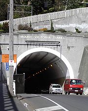
, opened 1978, three lanes (two northbound, one southbound), under The Terrace, Wellington. - SH 1 Mount Victoria TunnelMount Victoria TunnelThe Mount Victoria Tunnel in the New Zealand capital city of Wellington is 623 metres long and 5 metres in height, connecting Hataitai to the centre of Wellington and the suburb of Mount Victoria, under the mount of the same name...
- 623 m long - opened 1931, Mount Victoria, WellingtonMount Victoria, WellingtonMount Victoria, locally abbreviated to Mt. Vic, is a prominent hill to the east of the centre of Wellington, New Zealand, and its associated suburb. To the south of it is a spur, Mount Albert, and the two are linked by a ridge....
. - SH 1 Johnstone's Hill Tunnels, on the Auckland Northern MotorwayAuckland Northern MotorwayThe Auckland Northern Motorway is a major motorway in the Auckland Region of New Zealand, linking central Auckland City and Puhoi in the Rodney District, via the Hibiscus Coast and North Shore...
extension (Toll) near Puhoi - 340 m long. Opened 25 January 2009. - SH 1 Two short twin one-way tunnel pairs on the coast a few kilometres south of KaikouraKaikouraKaikoura is a town on the east coast of the South Island of New Zealand. It is located on State Highway 1 180 km north of Christchurch.Kaikoura became the first local authority to reach the Green Globe tourism certification standard....
. A third (railway) tunnel is adjacent. - SH 1 Victoria Park TunnelVictoria Park TunnelThe Victoria Park Tunnel is a motorway tunnel under construction on New Zealand State Highway 1 in Auckland, New Zealand. When finished end of 2011, it is to take the northbound traffic off the Victoria Park Viaduct, which will then be converted to all southbound traffic...
in Auckland - 440m long, 3 lanes of northbound traffic (none southbound), just prior to Harbour Bridge approaches. Opened 14 November 2011. The positioning of the tunnel allows a southbound tunnel to be built in the future (project yet to receive construction funding). - SH 3New Zealand State Highway 3State Highway 3 is one of New Zealand's eight national highways. It serves the west coast of the country's North Island and forms a link between State Highway 1 and State Highway 2...
Two short (less than 50 m long) tunnels between New PlymouthNew PlymouthNew Plymouth is the major city of the Taranaki Region on the west coast of the North Island of New Zealand. It is named after Plymouth, Devon, England, from where the first English settlers migrated....
and Te KuitiTe KuitiTe Kuiti is a small town in the south of the Waikato region of the North Island of New Zealand. It lies at the junction of State Highways 3 and 30 and on the North Island Main Trunk Railway, 80 km south of Hamilton....
: AwakinoAwakinoAwakino is a settlement in the south of Waitomo District, in the North Island of New Zealand. It is located on State Highway 3 at the mouth of the Awakino River, five kilometres north of Mokau. It is 79 km southwest of Te Kuiti, and 98 km northeast of New Plymouth.North of Awakino, State...
Gorge (single-lane), and Mt Messenger. - SH 43New Zealand State Highway 43New Zealand State Highway 43, also called the Forgotten World Highway, is a road that runs 158 km from Stratford, New Zealand in Taranaki to Taumarunui in the King Country...
Moki Tunnel - approx 200 m long, single lane, between WhangamomonaWhangamomonaWhangamomona is a small township in the Stratford District and Manawatu-Wanganui Region in New Zealand. It lies on State Highway 43, the Lost World Highway north-east of Stratford and south-west of Ohura. By rail it is from Stratford on the Stratford-Okahukura railway line.- History :The first...
and TaumarunuiTaumarunuiTaumarunui is a town in the King Country of the central North Island of New Zealand. It is on State Highway 4 and the North Island Main Trunk Railway....
- uses wooden shoring. - SH 74New Zealand State Highway 74State Highway 74 is a State Highway in New Zealand servicing the eastern suburbs of Christchurch, in addition to connecting the city to its port town of Lyttelton...
Lyttelton road tunnelLyttelton Road TunnelThe Lyttelton road tunnel links the New Zealand city of Christchurch and its seaport, Lyttelton. It opened in 1964 and carries just over 10,000 vehicles/day...
- 1900 m long - opened 1964, between Lyttelton and the Heathcote ValleyHeathcote Valley-Location:The suburb is dominated by the approaches to the Lyttelton road tunnel, a major arterial that passes through the Port Hills. The road is part of the State Highway 74 network...
in Christchurch. - SH 94New Zealand State Highway 94State Highway 94 is a New Zealand State Highway connecting the large Southland town of Gore with one of New Zealand's most popular destinations Milford Sound. It also passes the significant townships of Lumsden and Te Anau as well going through the Homer Tunnel...
Homer TunnelHomer TunnelThe Homer Tunnel is a road tunnel in the Fiordland region of the South Island of New Zealand, opened in 1954. New Zealand State Highway 94 passes through the tunnel, linking Milford Sound to Te Anau and Queenstown, by piercing the Main Divide at the Homer Saddle...
- 1200 m long - completed 1953, opened 1954, between Hollyford ValleyHollyford RiverThe Hollyford River is located in the southwest of the South Island of New Zealand. It runs for eighty miles in Fiordland, its source being ten kilometres to the north of the northern tip of Lake Te Anau and close to the Homer Tunnel....
and Milford SoundMilford SoundMilford Sound is a fjord in the south west of New Zealand's South Island, within Fiordland National Park, Piopiotahi Marine Reserve, and the Te Wahipounamu World Heritage site...
, FiordlandFiordlandFiordland is a geographic region of New Zealand that is situated on the south-western corner of the South Island, comprising the western-most third of Southland. Most of Fiordland is dominated by the steep sides of the snow-capped Southern Alps, deep lakes and its ocean-flooded, steep western valleys...
. Mean altitude 945 m. Unlined rock.
On other roads
- Okaihau, a short tunnel north of Okaihau constructed for the Okaihau BranchOkaihau BranchThe Okaihau Branch, sometimes known as the Kaikohe Branch and rarely the Rangiahua Branch, was a branch line railway that joined the North Auckland Line of the national rail network of New Zealand at Otiria. It was the most northerly line in New Zealand and was intended to run all the way to Kaitaia...
railway, which is accessible to vehicles.
In rural Taranaki, all single lane:
- Huinga Tunnel, near the village of the same name, provides access to an isolated valley.
- Kiwi Road Tunnels: the eastern one on Kiwi Road, the western on Moki Road, near Uruti Road.
- Makahu Tunnel on Brewer Road, providing access to the small village of MakahuMakahuMakahu is a settlement in inland Taranaki, in the western North Island of New Zealand. It is located to the southeast of Strathmore. the Makahu Stream runs south through the area to join with the Mangaehu Stream, which flows into the Patea River....
(white hawk). - Matau Tunnel on Mangaoapa Road, connecting Matau and Douglas via Kiore.
- Moki Stock Tunnel, hidden away in the bush to the east of the Kiwi Tunnels.
- Okau Tunnel, approximately 100 m long, on the TongaporutuTongaporutuTongaporutu is a settlement in northern Taranaki, in the North Island of New Zealand. It is located on State Highway 3 at the mouth of the Tongaporutu River, 15 kilometres south of Mokau.Tongaporutu is well known in New Zealand for its 'Three Sisters' rock formations and its Maori petroglyphs...
-OhuraOhuraOhura is a small town in the west of the North Island of New Zealand. It is located to the west of Taumarunui in the area known as the King Country, in inland Manawatu-Wanganui...
road 4 km from SH 3, which is unusual in that it abuts directly to a bridge. - Tangahoe Tunnel in South Taranaki - has recently been re-opened.
- Tarata Tunnel on Otaraoa Road, about 30 m long, built as the hill above was unstable.
- Te Horo Stock Tunnel, near the Whitecliffs Walkway
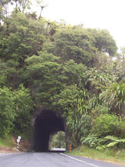
- Uruti Tunnel on Uruti Road, connecting the Pehu Valley with SH 3. It is both the longest (at about 200 m) and least stable tunnel in Taranaki. It took seven years to construct and opened in 1923. Signs at each end recommend not walking through it and stopping is prohibited. It looks like a mine shaft with its inverted V shaped top, has a wooden ceiling, and reinforcing planks along its walls.
- Whangamomona Road Tunnels, two short tunnels, 4WD only
In Wellington:
- HataitaiHataitaiHataitai is an inner-city suburb of Wellington, the capital of New Zealand, 3.5 kilometres southeast of the city centre. The suburb extends over the southeastern flank of Mount Victoria and down a valley between the Town Belt and a ridge along the shoreline of Evans Bay...
bus tunnel - 388 m long, single lane - under Mount Victoria; opened 1907 as a tramWellington tramway systemThe Wellington tramway system operated in Wellington, the capital of New Zealand. The tramways were originally owned by a private company, but were purchased by the city and formed a major part of the city's transport system.-Trams:...
tunnel. - KaroriKaroriKarori is a suburb located at the western edge of the urban area of Wellington, New Zealand, some 4 km from the city centre.Karori is significantly larger than most other Wellington suburbs, having a population of over 14,000 at the time of the 2006 census.-History:Before the arrival of...
Tunnel - 74 m long - between KelburnKelburn, New Zealandthumb|300px|Panorama of Wellington including the Kelburn cable car.Kelburn is an inner suburb of Wellington, New Zealand. It is located on the hills to the west of the Central Business District.-Features of Kelburn:...
and KaroriKaroriKarori is a suburb located at the western edge of the urban area of Wellington, New Zealand, some 4 km from the city centre.Karori is significantly larger than most other Wellington suburbs, having a population of over 14,000 at the time of the 2006 census.-History:Before the arrival of...
; opened 1900. - Moa Point Tunnel - under the safety zone at the south end of Wellington International Airport's runway.
- NorthlandNorthland, WellingtonNorthland, a small suburb in western Wellington, New Zealand. The suburb is served by two state primary schools, Northland School and Cardinal McKeefry Catholic Primary School....
Tunnel - 90 m long - between Northland and Karori. - SeatounSeatounSeatoun is an eastern suburb of Wellington, the capital city of New Zealand. It is on the east coast of the Miramar Peninsula, close to the entrance to Wellington Harbour , some seven kilometres southeast of the CBD...
tunnel - 144 m long - between Strathmore and Seatoun, opened 1907.
Road
- Waterview Connection, Auckland. This tunnel will be 2.4km long and will link SH20 with SH16New Zealand State Highway 16State Highway 16 is a New Zealand state highway linking Auckland City with Wellsford, via Auckland's Northwestern Motorway, Helensville and Kaukapakapa...
, forming an important connection in the Western Ring RouteWestern Ring RouteThe Western Ring Route is a motorway system being constructed in Auckland, New Zealand. It runs along three existing state highways: the Southwestern Motorway , the Northwestern Motorway and the Upper Harbour Highway . When finished it will surpass the Southern Motorway to become the longest...
. - Kaimai road tunnel - A tunnel through the Kaimai Range in order to provide a better roading connection between the WaikatoWaikatoThe Waikato Region is a local government region of the upper North Island of New Zealand. It covers the Waikato, Hauraki, Coromandel Peninsula, the northern King Country, much of the Taupo District, and parts of Rotorua District...
and Bay of Plenty regions has been proposed. One option for this tunnel includes building it near the existing Kaimai Rail TunnelKaimai TunnelThe Kaimai Tunnel is a railway tunnel through the Kaimai Range in the North Island of New Zealand. Since it was opened in 1978, it has held the title of longest tunnel in New Zealand, assuming this distinction from the previous title holder, the Rimutaka Tunnel...
.
Rail
- Auckland CBD rail linkAuckland city centre rail tunnelAn Auckland, New Zealand city centre / CBD rail tunnel has been proposed at various times during Auckland's history...
, Auckland. This is a proposed 3.5km rail tunnel underneath the Auckland CBDAuckland CBDThe Auckland CBD is the geographical and economic heart of the Auckland metropolitan area. Bounded by several major motorways and by the harbour coastline in the north, it is surrounded further out by mostly suburban areas...
between BritomartBritomart Transport CentreBritomart Transport Centre is the CBD public transport hub of Auckland, New Zealand, and the northern terminus of the North Island Main Trunk line. It combines a bus interchange with a railway station in a former Edwardian post office, extended with expansive post-modernist architectural elements...
and Mt Eden. As of 2011, it has not received funding.
Mixed Use
- Second Harbour Crossing in Auckland, likely to be a tunnel option that will incorporate the Victoria Park TunnelVictoria Park TunnelThe Victoria Park Tunnel is a motorway tunnel under construction on New Zealand State Highway 1 in Auckland, New Zealand. When finished end of 2011, it is to take the northbound traffic off the Victoria Park Viaduct, which will then be converted to all southbound traffic...
. While primarily a road tunnel, this tunnel may include rail links as well.