
Kelburn, New Zealand
Encyclopedia

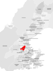
Wellington
Wellington is the capital city and third most populous urban area of New Zealand, although it is likely to have surpassed Christchurch due to the exodus following the Canterbury Earthquake. It is at the southwestern tip of the North Island, between Cook Strait and the Rimutaka Range...
, New Zealand
New Zealand
New Zealand is an island country in the south-western Pacific Ocean comprising two main landmasses and numerous smaller islands. The country is situated some east of Australia across the Tasman Sea, and roughly south of the Pacific island nations of New Caledonia, Fiji, and Tonga...
. It is located on the hills to the west of the Central Business District
Central business district
A central business district is the commercial and often geographic heart of a city. In North America this part of a city is commonly referred to as "downtown" or "city center"...
.
Features of Kelburn
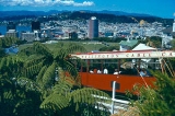
Though not large in terms of population, the suburb has a number of distinguishing features.The Wellington Cable Car
Wellington Cable Car
The Wellington Cable Car is a funicular railway in Wellington, New Zealand between Lambton Quay, the main shopping street, and Kelburn, a suburb in the hills overlooking the central city, rising 120 m over a length of 612 m. It is widely recognised as a symbol of Wellington.-Track and stations:The...
(built in 1902) is a tourist attraction and essential transport facility. It runs from Lambton Quay
Lambton Quay, Wellington
Lambton Quay is the heart of the central business district of Wellington, the capital city of New Zealand.Originally, as the name implies, it was the high-water line of the foreshore, and sometimes the sea would roll across the road and enter the shops on the opposite side. It was the site of the...
in the CBD up the hill for 800 m, crossing the Wellington Urban Motorway as it does so. Its terminal is close to the Wellington Botanic Garden
Wellington Botanic Garden
The Wellington Botanic Garden, Wellington, New Zealand, covers 25 hectares of land on the side of the hill between Thorndon and Kelburn, near central Wellington....
and the Carter Observatory
Carter Observatory
The Carter Observatory stands at the top of the Botanic Gardens in Wellington, New Zealand. It re-opened in March 2010 following a NZ$5 million refurbishment, with a new exhibition and digital planetarium celebrating the culture, heritage and science of the Southern Skies.- History :The name...
. Both of these are popular destinations for locals and visitors alike.
The main campus of Victoria University of Wellington
Victoria University of Wellington
Victoria University of Wellington was established in 1897 by Act of Parliament, and was a former constituent college of the University of New Zealand. It is particularly well known for its programmes in law, the humanities, and some scientific disciplines, but offers a broad range of other courses...
is located in the east of the suburb, and the second-top stop of the cable car provides easy access.
Other features include the Kelburn Viaduct, one of the oldest bridges of its type in New Zealand, connecting to Karori
Karori
Karori is a suburb located at the western edge of the urban area of Wellington, New Zealand, some 4 km from the city centre.Karori is significantly larger than most other Wellington suburbs, having a population of over 14,000 at the time of the 2006 census.-History:Before the arrival of...
, and the Kelburn shopping area.
Demographics
Kelburn (especially the area bounded by the Wellington Urban MotorwayWellington Urban Motorway
The Wellington Urban Motorway, part of SH 1, is the major road into and out of Wellington, New Zealand. It is 7 km long, ranges from three to six lanes wide, and extends from the base of the Ngauranga Gorge into the Wellington CBD....
, Kelburn Park and the Botanic Gardens
Wellington Botanic Garden
The Wellington Botanic Garden, Wellington, New Zealand, covers 25 hectares of land on the side of the hill between Thorndon and Kelburn, near central Wellington....
) has historically been the home of New Zealand's Business elite such as the Todd family (one of New Zealand's richest families) (the area has the nickname "Todd Hill"), Sir Ron Trotter and Lloyd Morrison (of Infratil
Infratil
Infratil Limited is a New Zealand-based infrastructure investment company. It owns several airports, electricity generators and retailers, and a public transport business, with operations in New Zealand, Australia and Europe. Infratil was founded by Lloyd Morrison, a Wellington-based merchant...
). The New Zealand legal elite are also well represented in this area (for example Sir Kenneth Keith
Kenneth Keith
Sir Kenneth James Keith, ONZ, KBE, QC is a New Zealand judge appointed to the International Court of Justice in November 2005....
and Sir John McGrath
John McGrath (judge)
Sir John Joseph McGrath, KNZM, QC is a Judge of the Supreme Court of New Zealand. He was formerly the Solicitor-General of New Zealand for eleven years from 1989, before being made a judge of the Court of Appeal of New Zealand in 2000. He was elevated to the Supreme Court in 2005.-Career:Justice...
). The wider suburb is the home of many upper-middle class families due to the views of Wellington, the Wellington Botanic Garden
Wellington Botanic Garden
The Wellington Botanic Garden, Wellington, New Zealand, covers 25 hectares of land on the side of the hill between Thorndon and Kelburn, near central Wellington....
, proximity to town and the high level of sunshine in the top parts (there are also a number of glen
Glen
A glen is a valley, typically one that is long, deep, and often glacially U-shaped; or one with a watercourse running through such a valley. Whittow defines it as a "Scottish term for a deep valley in the Highlands" that is "narrower than a strath."...
s). Due to Kelburn's proximity to the University, many students live in flats
Apartment
An apartment or flat is a self-contained housing unit that occupies only part of a building...
or rental accommodation here. A large number of academics also call Kelburn home, resulting in a diverse community. The 2006 census gives the population of Kelburn as approximately 3,600.
History
Kelburn, built on the former ‘Upland Farm’ (giving the names to Kelburn's main street, Upland Road), was one of the earliest settled suburbs of Wellington due its proximity to the main government/commercial district of Wellington. Kelburn is named after Viscount KelburnePatrick Boyle, 8th Earl of Glasgow
Patrick James Boyle, 8th Earl of Glasgow was a Scottish nobleman and a far right political activist.-Royal Navy:...
, the son of a former governor David Boyle
David Boyle, 7th Earl of Glasgow
David Boyle, 7th Earl of Glasgow, GCMG was a Governor of New Zealand.-Royal Navy:Boyle served with the Royal Navy during the Crimean and Second Opium Wars...
, Lord Glasgow, Governor of New Zealand between 1892 and 1897. At some point in time the 'e' was dropped due to the confusion with the suburb of Kilbirnie
Kilbirnie, New Zealand
Kilbirnie , a suburb of Wellington in New Zealand, lies 3 kilometers to the south-east of the city centre. Travellers can reach Kilbirnie from the Wellington central business district either via the Mount Victoria Tunnel and Hataitai; over Mount Victoria; or around the coast...
, leaving the modern suburb name as 'Kelburn'. For example early photographs of the Wellington Cable Car
Wellington Cable Car
The Wellington Cable Car is a funicular railway in Wellington, New Zealand between Lambton Quay, the main shopping street, and Kelburn, a suburb in the hills overlooking the central city, rising 120 m over a length of 612 m. It is widely recognised as a symbol of Wellington.-Track and stations:The...
show the sign writing on the side using the spelling 'Kelburne'.
Boundaries
Aro Valley
- Geography :The Aro Valley runs between the hills of Brooklyn to the south and of Kelburn to the north. By some reckonings it includes the side-valley of Mitchelltown. It takes its name from the Aro stream which flowed down Epuni street, and which since 1926 has been confined to a drain...
forming the South boundary