
Wairoa
Encyclopedia
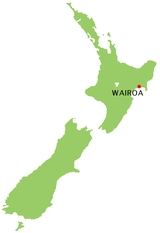
Wairoa is a town in New Zealand
's North Island
. It is the northernmost town in the Hawke's Bay region, and is located on the northern shore of Hawke Bay
at the mouth of the Wairoa River
and to the west of Mahia Peninsula
. It is 70 kilometres northeast of Napier
, and a similar distance southwest of Gisborne
.
Wairoa is Māori
for long water.
Early settlement in the area included a whaling
station and trading post, dealing largely in flax
. Its initial name was Clyde, but this was changed largely to avoid confusion with Clive
near Napier and Clyde
in the South Island
. The north part of the town is called North Clyde. The town rose to prominence during the New Zealand Wars, during which time it was a garrison town.
Wairoa is a manufacturing and farming service town. It is the seat of the Wairoa District Council. The Wairoa District covers the northern half of the bay's coast, and extends from Mahia Peninsula
to Lake Waikaremoana
, and south to the mouth of the Waikare River
. It has a population of 8,481 inhabitants (2006 census). The District has a land area of 4,119.18 km2 (1,590.42 sq mi).
Wairoa has one secondary school, Wairoa College
.
Wairoa is situated on the SH2
, which gives connections to Gisborne to the north east and Napier to the south west. It is connected to the Central North Island by SH38
which goes from Wai-O-Tapu via Murupara
and Frasertown
to Wairoa, and which connects to Rotorua
via Te Urewera
, and Lake Waikaremoana.
Since 2005, Wairoa has been host to the annual Wairoa Maori Film Festival
, New Zealand's premiere Maori and indigenous film festival, which has hosted film makers from across the nation and around the world.
In 2010 Wairoa was subject to gang incidents between the Mongrel Mob
and Black Power
gangs.
The current mayor is Les Probert, who has held the position since 2001. His deputy is Denise Eaglesome.
New Zealand
New Zealand is an island country in the south-western Pacific Ocean comprising two main landmasses and numerous smaller islands. The country is situated some east of Australia across the Tasman Sea, and roughly south of the Pacific island nations of New Caledonia, Fiji, and Tonga...
's North Island
North Island
The North Island is one of the two main islands of New Zealand, separated from the much less populous South Island by Cook Strait. The island is in area, making it the world's 14th-largest island...
. It is the northernmost town in the Hawke's Bay region, and is located on the northern shore of Hawke Bay
Hawke Bay
Hawke Bay is a large bay on the eastern coast of the North Island of New Zealand. It stretches from the Mahia Peninsula in the northeast to Cape Kidnappers in the southwest, a distance of some 100 kilometres....
at the mouth of the Wairoa River
Wairoa River, Hawke's Bay
The Wairoa River runs south for 65 kilometres from the inland east coast region of New Zealand's North Island, west of Gisborne, before flowing into northern Hawke Bay at the town of Wairoa....
and to the west of Mahia Peninsula
Mahia Peninsula
The Mahia Peninsula is located on the east coast of New Zealand's North Island, between the cities of Napier and Gisborne.-Geography:The peninsula is long and wide rising to its highest point at Rahuimokairoa reaching about above sea level. Mahia was initially an island which over time, has had...
. It is 70 kilometres northeast of Napier
Napier, New Zealand
Napier is a New Zealand city with a seaport, located in Hawke's Bay on the eastern coast of the North Island. The population of Napier is about About 18 kilometres south of Napier is the inland city of Hastings. These two neighboring cities are often called "The Twin Cities" or "The Bay Cities"...
, and a similar distance southwest of Gisborne
Gisborne, New Zealand
-Economy:The harbour was host to many ships in the past and had developed as a river port to provide a more secure location for shipping compared with the open roadstead of Poverty Bay which can be exposed to southerly swells. A meat works was sited beside the harbour and meat and wool was shipped...
.
Wairoa is Māori
Maori language
Māori or te reo Māori , commonly te reo , is the language of the indigenous population of New Zealand, the Māori. It has the status of an official language in New Zealand...
for long water.
Early settlement in the area included a whaling
Whaling
Whaling is the hunting of whales mainly for meat and oil. Its earliest forms date to at least 3000 BC. Various coastal communities have long histories of sustenance whaling and harvesting beached whales...
station and trading post, dealing largely in flax
New Zealand flax
New Zealand flax describes common New Zealand perennial plants Phormium tenax and Phormium cookianum, known by the Māori names harakeke and wharariki respectively...
. Its initial name was Clyde, but this was changed largely to avoid confusion with Clive
Clive, New Zealand
The small town of Clive is located ten kilometres south of Napier in the Hawke's Bay region of New Zealand's North Island. It is close to the mouth of the Ngaruroro River....
near Napier and Clyde
Clyde, New Zealand
Clyde is a small town in Central Otago, New Zealand with a population of 918 in 2006. It is located on the Clutha River, between Cromwell and Alexandra....
in the South Island
South Island
The South Island is the larger of the two major islands of New Zealand, the other being the more populous North Island. It is bordered to the north by Cook Strait, to the west by the Tasman Sea, to the south and east by the Pacific Ocean...
. The north part of the town is called North Clyde. The town rose to prominence during the New Zealand Wars, during which time it was a garrison town.
Wairoa is a manufacturing and farming service town. It is the seat of the Wairoa District Council. The Wairoa District covers the northern half of the bay's coast, and extends from Mahia Peninsula
Mahia Peninsula
The Mahia Peninsula is located on the east coast of New Zealand's North Island, between the cities of Napier and Gisborne.-Geography:The peninsula is long and wide rising to its highest point at Rahuimokairoa reaching about above sea level. Mahia was initially an island which over time, has had...
to Lake Waikaremoana
Lake Waikaremoana
Lake Waikaremoana is located in Te Urewera National Park in the North Island of New Zealand, 60 kilometres northwest of Wairoa and 80 kilometres southwest of Gisborne. It covers an area of 54 km². From the Maori Waikaremoana translates as 'sea of rippling waters'The lake lies in the heart of Tuhoe...
, and south to the mouth of the Waikare River
Waikare River
Waikare River is the name of two rivers in the North Island of New Zealand.* Waikare River * Waikare River...
. It has a population of 8,481 inhabitants (2006 census). The District has a land area of 4,119.18 km2 (1,590.42 sq mi).
Wairoa has one secondary school, Wairoa College
Wairoa College
Wairoa College is a secondary school. It was expanded to include students from years 7 and 8 in 2005. A building project to accommodate the increased roll was complete by 2008....
.
Wairoa is situated on the SH2
New Zealand State Highway 2
State Highway 2 is one of New Zealand's eight national highways. With the exception of State Highway 1, which runs the length of both of the country's main islands, SH 2 is the longest highway in the North Island...
, which gives connections to Gisborne to the north east and Napier to the south west. It is connected to the Central North Island by SH38
New Zealand State Highway 38
State Highway 38 is one of New Zealand's State Highways on the North Island. It starts near Wai-O-Tapu at the intersection with SH 5 and it ends at Wairoa, where it connects to SH 2. It is the shortest connection from the Central North Island to the East Coast , but it is not often used as such...
which goes from Wai-O-Tapu via Murupara
Murupara
Murupara is a town located in the North Island of New Zealand. The town is situated in an isolated part of the Bay of Plenty region between the Kaingaroa Forest and Te Urewera National Park, on the banks of the Rangitaiki River, 65 kilometres southeast of Rotorua, along SH38. Murupara is the...
and Frasertown
Frasertown
Frasertown is a small settlement in the northern Hawke's Bay Region of New Zealand's eastern North Island. It is located inland from Wairoa at the junction of SH38, and the inland route to Gisborne....
to Wairoa, and which connects to Rotorua
Rotorua
Rotorua is a city on the southern shores of the lake of the same name, in the Bay of Plenty region of the North Island of New Zealand. The city is the seat of the Rotorua District, a territorial authority encompassing the city and several other nearby towns...
via Te Urewera
Te Urewera
Te Urewera is an area of the central North Island of New Zealand. Located in rough, sparsely populated hill country to the northeast of Lake Taupo, it is the historical home of Tuhoe, a Māori iwi known for their controversial stance on Māori sovereignty...
, and Lake Waikaremoana.
Since 2005, Wairoa has been host to the annual Wairoa Maori Film Festival
Wairoa Maori Film Festival
The Wairoa Māori Film Festival is New Zealand's premiere Māori and indigenous film festival.The festival is held annually in the small coastal town of Wairoa, Hawke's Bay, during the Matariki celebration period....
, New Zealand's premiere Maori and indigenous film festival, which has hosted film makers from across the nation and around the world.
In 2010 Wairoa was subject to gang incidents between the Mongrel Mob
Mongrel Mob
The Mongrel Mob is a New Zealand gang, originally formed in Hawke's Bay in the 1960s and early 1970s.The gang offers a surrogate 'family' for young men, most of whom are often alienated from their family via joining. Members are from New Zealand's Maori, European or other Polynesian ethnic groups,...
and Black Power
Black Power (New Zealand)
Black Power is a prominent gang in New Zealand. It was formed as the "Black Bulls" by Rei Harris and Māori youth in Wellington about 1970, in response to the rival Mongrel Mob gang and enemy White Power associated gangs. The gang then spread to other major centres and rural towns in New Zealand...
gangs.
The current mayor is Les Probert, who has held the position since 2001. His deputy is Denise Eaglesome.
External links
- Wairoa Help and Information Centre
- Wairoa i-SITE Visitor Information and Travel Centre
- Official website of Wairoa District Council