

Wellington tramway system
Encyclopedia
Wellington
Wellington is the capital city and third most populous urban area of New Zealand, although it is likely to have surpassed Christchurch due to the exodus following the Canterbury Earthquake. It is at the southwestern tip of the North Island, between Cook Strait and the Rimutaka Range...
, the capital of New Zealand
New Zealand
New Zealand is an island country in the south-western Pacific Ocean comprising two main landmasses and numerous smaller islands. The country is situated some east of Australia across the Tasman Sea, and roughly south of the Pacific island nations of New Caledonia, Fiji, and Tonga...
. The tramways were originally owned by a private company, but were purchased by the city and formed a major part of the city's transport system.
Trams
Initially in 1878, Wellington's trams were steam-powered, with an engine drawing a separate carriage. The engines were widely deemed unsatisfactory, however — they created a great deal of soot, were heavy (increasing track maintenance costs), and often frightened horses. By 1882, a combination of public pressure and financial concerns caused the engines to be replaced by horses. In 1902, after the tramways came into public ownership, it was decided to electrify the system, and the first electric tram ran in 1904. Trams operated singly, and were mostly single-deck but some double-deck.Lines
The first tram line in Wellington opened on 24 August 1878. The line was 4.5 km in length, and ran between the north end of Lambton QuayLambton Quay, Wellington
Lambton Quay is the heart of the central business district of Wellington, the capital city of New Zealand.Originally, as the name implies, it was the high-water line of the foreshore, and sometimes the sea would roll across the road and enter the shops on the opposite side. It was the site of the...
and a point just south of the Basin Reserve.
After 1900, when the tramway was bought by the city authorities and electrified, a major extension of the network took place, with lines to Aro Street, Oriental Bay, and Tinakori Road in operation in 1904. The following year, a line was constructed through Newtown and Berhampore to Island Bay, and the year after, from the Te Aro line to Brooklyn
Brooklyn, New Zealand
Brooklyn, a suburb of Wellington, the capital city of New Zealand. Brooklyn is a blend of circa 1900 weatherboard villa / bungalow houses around the central part of Brooklyn, blending more recent subdivisions built in the 1970's and 1990's. The shops / bars / cinema / food outlets have created a...
. In 1907, a dedicated tram tunnel to Hataitai
Hataitai
Hataitai is an inner-city suburb of Wellington, the capital of New Zealand, 3.5 kilometres southeast of the city centre. The suburb extends over the southeastern flank of Mount Victoria and down a valley between the Town Belt and a ridge along the shoreline of Evans Bay...
was completed, allowing services to reach Kilbirnie
Kilbirnie, New Zealand
Kilbirnie , a suburb of Wellington in New Zealand, lies 3 kilometers to the south-east of the city centre. Travellers can reach Kilbirnie from the Wellington central business district either via the Mount Victoria Tunnel and Hataitai; over Mount Victoria; or around the coast...
, Miramar
Miramar, New Zealand
Miramar is a suburb of Wellington, New Zealand, south-east of the city centre. It is on the Miramar Peninsula, directly east of the isthmus of Rongotai, the site of Wellington International Airport.-History:...
, and Seatoun
Seatoun
Seatoun is an eastern suburb of Wellington, the capital city of New Zealand. It is on the east coast of the Miramar Peninsula, close to the entrance to Wellington Harbour , some seven kilometres southeast of the CBD...
. The Tinakori Road line was extended westward towards Karori
Karori
Karori is a suburb located at the western edge of the urban area of Wellington, New Zealand, some 4 km from the city centre.Karori is significantly larger than most other Wellington suburbs, having a population of over 14,000 at the time of the 2006 census.-History:Before the arrival of...
, reaching Karori Cemetery.
Construction of new track then slowed, but did not stop. In 1911, a line was built from Kilbirnie to Lyall Bay
Lyall Bay
Lyall Bay is a bay and a suburb on the south side of the Rongotai isthmus in Wellington, New Zealand.The bay is a popular surf beach, featuring a breakwater at the eastern end. It has also been the site of surf lifesaving championships, and is home to two surf lifesaving clubs. Lyall Bay is a very...
and from Tinakori Road to Wadestown. By this time, the Karori line had been extended to Karori Park. In 1915, a line was built to connect Newtown with Kilbirnie, via Constable Street and Crawford Road. Finally, in 1929, the last new line was completed, a branch of the Karori line through a tunnel to Northland
Northland, Wellington
Northland, a small suburb in western Wellington, New Zealand. The suburb is served by two state primary schools, Northland School and Cardinal McKeefry Catholic Primary School....
.
Wellington's more northerly suburbs, such as Johnsonville
Johnsonville, New Zealand
Johnsonville is a large suburb in northern Wellington, New Zealand. It is seven kilometres north of the city centre, at the top of the Ngauranga Gorge, on the main route to Porirua . The population of "J'ville" was about 6,500 at the 2001 census.- Public transport :Johnsonville is a reasonably...
and Tawa
Tawa, New Zealand
Tawa is the northernmost suburb of Wellington located between Churton Park and Porirua in the North Island of New Zealand. It takes its name from the broadleaf tree, which was once prolific throughout the area, although its most famous tree is the Bucket Tree, a group of large macrocarpa with the...
, were not served by the tram network, as they were (and are) served by the Wellington railway system. The Wellington Cable Car
Wellington Cable Car
The Wellington Cable Car is a funicular railway in Wellington, New Zealand between Lambton Quay, the main shopping street, and Kelburn, a suburb in the hills overlooking the central city, rising 120 m over a length of 612 m. It is widely recognised as a symbol of Wellington.-Track and stations:The...
, another part of Wellington's transport network, is sometimes described as a tram, but is not generally considered so. It was opened in 1902, and is still in operation.
Wellington's electric tramways had the unusual gauge
Rail gauge
Track gauge or rail gauge is the distance between the inner sides of the heads of the two load bearing rails that make up a single railway line. Sixty percent of the world's railways use a standard gauge of . Wider gauges are called broad gauge; smaller gauges, narrow gauge. Break-of-gauge refers...
of , a narrow gauge
Narrow gauge
A narrow gauge railway is a railway that has a track gauge narrower than the of standard gauge railways. Most existing narrow gauge railways have gauges of between and .- Overview :...
. The steam and horse trams were gauge, the same as New Zealand's national railway gauge.
Map
The map below shows the Wellington tramway network at its greatest extent, superimposed on a map of the city as it is today.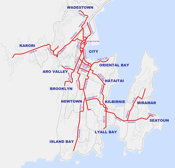
Closure
In the late 1940s and early 1950s it was decided to replace the trams with busBus
A bus is a road vehicle designed to carry passengers. Buses can have a capacity as high as 300 passengers. The most common type of bus is the single-decker bus, with larger loads carried by double-decker buses and articulated buses, and smaller loads carried by midibuses and minibuses; coaches are...
es and trolleybus
Trolleybus
A trolleybus is an electric bus that draws its electricity from overhead wires using spring-loaded trolley poles. Two wires and poles are required to complete the electrical circuit...
es, which were seen as more advanced and better suited to the city's needs. The topography of Wellington played a part in this decision - the city's streets are often steep, winding, and narrow, making the greater manoeuvrability of buses a significant asset. The principle of electric transport was retained — many of the tram routes are now served by trolleybus
Trolleybus
A trolleybus is an electric bus that draws its electricity from overhead wires using spring-loaded trolley poles. Two wires and poles are required to complete the electrical circuit...
es, see Trolleybuses in Wellington
Trolleybuses in Wellington
Trolleybuses in Wellington form part of the Wellington public transport system, with the current system having operated since 1949. Wellington's trolleybus system is the only one still operating in Oceania, and one of the few in the English-speaking world, and the world's only right-hand-drive...
.
The first major line closure came in 1949, when Wadestown closed. The following year the Oriental Bay line closed. In 1954, the Karori line (including the Northland branch) closed. In 1957 services to Aro Street and Brooklyn ended, and the construction of Wellington International Airport
Wellington International Airport
Wellington International Airport is an international airport located in the suburb of Rongotai in Wellington, the capital city of New Zealand. It is a secondary hub and focus city for Air New Zealand and its subsidiaries...
destroyed the route to Miramar and Seatoun. All services to the eastern suburbs had ceased by 1962, with Lyall Bay closing in 1960, Constable St/Crawford Rd in 1961, and Hataitai in 1962. (The Hataitai tram tunnel is still in use by buses.) In 1963, the service to Island Bay was withdrawn, leaving mainly inner-city routes. On 2 May 1964 the remaining portion was closed, with a parade from Thorndon to Newtown.
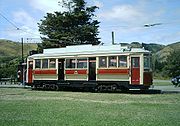
Some of Wellington's old trams have been preserved, and are now in operation at the Wellington Tramway Museum
Wellington Tramway Museum
The Wellington Tramway Museum is at Queen Elizabeth Park in New Zealand, near the overbridge at MacKays Crossing between Paekakariki and Paraparaumu, and has been operating trams there since 1965...
at Paekakariki
Paekakariki
Paekakariki is a town in the Kapiti Coast District in the south-western North Island of New Zealand. It is 22 km north of Porirua and 45 km north-east of Wellington, the nation's capital city....
. Occasionally, it has been suggested that trams should return to Wellington, either in a modern form or as a historical display — in the 1990s, a heritage line was proposed for the city's waterfront, and more recently, a light rail
Light rail
Light rail or light rail transit is a form of urban rail public transportation that generally has a lower capacity and lower speed than heavy rail and metro systems, but higher capacity and higher speed than traditional street-running tram systems...
line has been suggested through the city centre. As yet, however, there are no firm plans for any restoration.
Present
Trams still operate today, but only in the Wellington Tramway MuseumWellington Tramway Museum
The Wellington Tramway Museum is at Queen Elizabeth Park in New Zealand, near the overbridge at MacKays Crossing between Paekakariki and Paraparaumu, and has been operating trams there since 1965...
at Queen Elizabeth Park
Queen Elizabeth Park, New Zealand
Queen Elizabeth Park is a Wellington Regional Park located on the Kapiti Coast in New Zealand. The park contains the last area of natural dunes on the Kapiti Coast. The park is steeped in history including pa sites at Whareroa Beach and Wainui Beach....
in Paekakariki
Paekakariki
Paekakariki is a town in the Kapiti Coast District in the south-western North Island of New Zealand. It is 22 km north of Porirua and 45 km north-east of Wellington, the nation's capital city....
.
External links
- Wellington City Libraries tram page
- Wellington Tramway Museum
- Wellington Electric Tram 1904 on 1985 45c stanp
- View Photos (405) via Archives Search: search for 'tram', tick images only
- Photo of horse tram on The Quay 1900
- Photo of woman tram conductor 1943
- Photo of woman tramway employees repairing track 1944