
New Zealand State Highway 3
Encyclopedia
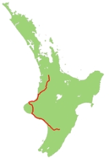
State Highway 3 is one of New Zealand
's eight national highways
. It serves the west coast of the country's North Island
and forms a link between State Highway 1
and State Highway 2. Distances are measured from north to south.
For most of its length SH3 is a two-lane single carriageway, with at-grade intersections and property accesses, both in rural and urban areas.
 The highway leaves SH1 at Hamilton, and initially heads south through farmland, passing through Te Awamutu
. Sections of this stretch of the road are four-laned, but not divided carriageway. From Otorohanga
it follows the valley of the Waipa River to Te Kuiti
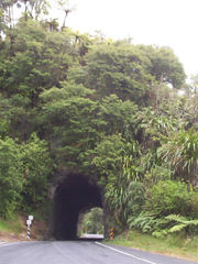
. The road then turns southwest through sparsely settled farmland, crossing several ridges before following the Awakino gorge to reach the coast, which it follows around the North Taranaki Bight. At the Tongaporutu River
the highway turns inland to avoid coastal cliffs and climbs over Mount Messenger before descending via the Mimi River
valley to return to the coast near Urenui
. Bypassing Waitara
, it reaches New Plymouth
then turns inland, passing to the east of Mount Taranaki
via Inglewood
, Stratford
and Eltham
to Hawera
.
From Hawera the highway follows the coast of the South Taranaki Bight southeastwards to Patea
and Wanganui
before meeting State Highway 1 again at Bulls
. Highways 1 and 3 share their route for 6 km as they cross the Rangitikei River
to Sanson
, where Highway 3 continues southeast towards Palmerston North
. After crossing the Manawatu River
, the route follows its south bank through the Manawatu Gorge
to its terminus and junction with State Highway 2 at Woodville
in the Wairarapa
.
Both the Awakino and Manawatu gorges are prone to closure by slips and rockslides in heavy rain.
, a satellite town of New Plymouth, was completed in 2010.
New Zealand
New Zealand is an island country in the south-western Pacific Ocean comprising two main landmasses and numerous smaller islands. The country is situated some east of Australia across the Tasman Sea, and roughly south of the Pacific island nations of New Caledonia, Fiji, and Tonga...
's eight national highways
New Zealand State Highway network
The New Zealand State Highway network is the major national highway network in New Zealand. Just under 100 roads in both the North and South Islands are State Highways...
. It serves the west coast of the country's North Island
North Island
The North Island is one of the two main islands of New Zealand, separated from the much less populous South Island by Cook Strait. The island is in area, making it the world's 14th-largest island...
and forms a link between State Highway 1
State Highway 1 (New Zealand)
State Highway 1 is the longest and most significant road in the New Zealand roading network, running the length of both main islands. It appears on road maps as SH 1 and on road signs as a white number 1 on a red shield, but it has the official designations SH 1N in the North Island, SH 1S in the...
and State Highway 2. Distances are measured from north to south.
For most of its length SH3 is a two-lane single carriageway, with at-grade intersections and property accesses, both in rural and urban areas.
Route
This is the route that SH3 takes in 2007.Te Awamutu
Te Awamutu is a town in the Waikato in the North Island of New Zealand. It is the council seat of the Waipa District and serves as a service town for the farming communities which surround it...
. Sections of this stretch of the road are four-laned, but not divided carriageway. From Otorohanga
Otorohanga
Otorohanga is a north King Country town at the southern end of the Waikato region in the North Island of New Zealand. It is located 53 kilometres south of Hamilton and 18 kilometres north of Te Kuiti, on the Waipa River...
it follows the valley of the Waipa River to Te Kuiti
Te Kuiti
Te Kuiti is a small town in the south of the Waikato region of the North Island of New Zealand. It lies at the junction of State Highways 3 and 30 and on the North Island Main Trunk Railway, 80 km south of Hamilton....
. The road then turns southwest through sparsely settled farmland, crossing several ridges before following the Awakino gorge to reach the coast, which it follows around the North Taranaki Bight. At the Tongaporutu River
Tongaporutu River
The Tongaporutu River is a river of the Taranaki Region of New Zealand's North Island. It initially flows north from its origins near Tahora, turning west to reach the Tasman Sea coast close to the settlement of Tongaporutu, 15 kilometres south of Mokau....
the highway turns inland to avoid coastal cliffs and climbs over Mount Messenger before descending via the Mimi River
Mimi River
The Mimi River is a river of the Taranaki Region of New Zealand's North Island. It flows generally southwest from its sources in rough hill country 25 kilometres northeast of Urenui to reach the sea five kilometres northeast of the town. State Highway 3 follows the valley of the Mimi River for part...
valley to return to the coast near Urenui
Urenui
Urenui is a settlement in northern Taranaki, in the North Island of New Zealand. It is located on State Highway 3 close to the shore of the North Taranaki Bight, 13 kilometres east of Waitara and 6 km south-west of Mimi...
. Bypassing Waitara
Waitara, New Zealand
Waitara is the name of a town and a river in the northern part of the Taranaki Region of the North Island of New Zealand. Waitara is located just off State Highway 3, 15 km northeast of New Plymouth....
, it reaches New Plymouth
New Plymouth
New Plymouth is the major city of the Taranaki Region on the west coast of the North Island of New Zealand. It is named after Plymouth, Devon, England, from where the first English settlers migrated....
then turns inland, passing to the east of Mount Taranaki
Mount Taranaki
Mount Taranaki, or Mount Egmont, is an active but quiescent stratovolcano in the Taranaki region on the west coast of New Zealand's North Island. Although the mountain is more commonly referred to as Taranaki, it has two official names under the alternative names policy of the New Zealand...
via Inglewood
Inglewood, New Zealand
Inglewood is a town in the Taranaki Region of New Zealand's North Island. The population was 3,090 in the 2006 Census, an increase of 144 from 2001. Inglewood lies 200m above sea level....
, Stratford
Stratford, New Zealand
Stratford is the only town in the central Taranaki district of Stratford District, New Zealand. It lies beneath the eastern slopes of Mount Taranaki/Egmont, approximately half-way between New Plymouth and Hawera, near the geographic centre of the Taranaki region. The town has a population of...
and Eltham
Eltham, New Zealand
thumb|left|The town center of ElthamEltham is a small inland town in South Taranaki, New Zealand, located 50 km south of the city of New Plymouth and southeast of the volcanic cone of Mount Taranaki/Egmont. Stratford is 11 km north, Kaponga 13 km west, and Hawera 19 km south....
to Hawera
Hawera
Hawera is the second-largest town in the Taranaki region of New Zealand's North Island, with a population of . It is near the coast of the South Taranaki Bight, 75 kilometres south of New Plymouth on State Highway 3 and 20 minutes' drive from Mount Taranaki/Egmont.It is also on State Highway 45,...
.
From Hawera the highway follows the coast of the South Taranaki Bight southeastwards to Patea
Patea
Patea is the third-largest town in South Taranaki, New Zealand. It is on the western bank of the Patea River, 61 kilometres north-west of Wanganui on State Highway 3. Hawera is 27 km to the north-west, and Waverley 17 km to the east. The Patea River flows through the town from the...
and Wanganui
Wanganui
Whanganui , also spelled Wanganui, is an urban area and district on the west coast of the North Island of New Zealand. It is part of the Manawatu-Wanganui region....
before meeting State Highway 1 again at Bulls
Bulls
Bulls may refer to:*Bulls, the male of cattle*Bulls, New Zealand, Rangitikei township*Papal bulls, a charter issued by a popeIn sports:*Bulls , a rugby union franchise operated by the Blue Bulls...
. Highways 1 and 3 share their route for 6 km as they cross the Rangitikei River
Rangitikei River
The Rangitikei River is one of New Zealand's longest rivers, 185 kilometers long.Its headwaters are to the southeast of Lake Taupo in the Kaimanawa Ranges. It flows from the Central Plateau south past Taihape, Mangaweka, Hunterville, Marton, and Bulls, to the South Taranaki Bight at Tangimoana, 40...
to Sanson
Sanson, New Zealand
Sanson is a small town in the Manawatu region of New Zealand. It is located just south of Bulls and the Rangitikei River, and west of the city of Palmerston North. The 2001 census revealed that Sanson's population was 495, a 4.6% decrease from the previous census in 1996...
, where Highway 3 continues southeast towards Palmerston North
Palmerston North
Palmerston North is the main city of the Manawatu-Wanganui region of the North Island of New Zealand. It is an inland city with a population of and is the country's seventh largest city and eighth largest urban area. Palmerston North is located in the eastern Manawatu Plains near the north bank...
. After crossing the Manawatu River
Manawatu River
The Manawatu River is a major river of the southern North Island of New Zealand.The river has its headwaters to the northwest of Norsewood in the Ruahine Ranges of southern Hawke's Bay. It flows initially eastward before turning south-west near Ormondville, flowing 40 km before turning...
, the route follows its south bank through the Manawatu Gorge
Manawatu Gorge
The Manawatu Gorge runs between the Ruahine and Tararua Ranges of the North Island of New Zealand, linking the Manawatu and Hawke's Bay regions...
to its terminus and junction with State Highway 2 at Woodville
Woodville, New Zealand
Woodville is a small town in the southern North Island of New Zealand, 75 km north of Masterton and 25 km east of Palmerston North. In the 2006 census 1,398 people are usually resident in Woodville, a decrease of 81 people, or 5.5%, since the 2001 Census.-Early History and Local...
in the Wairarapa
Wairarapa
Wairarapa is a geographical region of New Zealand. It occupies the south-eastern corner of the North Island, east of metropolitan Wellington and south-west of the Hawke's Bay region. It is lightly populated, having several rural service towns, with Masterton being the largest...
.
Both the Awakino and Manawatu gorges are prone to closure by slips and rockslides in heavy rain.
Route changes
Construction of a bypass of Bell BlockBell Block
Bell Block is a town in Taranaki, New Zealand. State Highway 3 runs through it. It is 6 km north-east of the centre of New Plymouth and 1 km from the outer edge of New Plymouth at Waiwhakaiho. Waitara is about 9 km to the north-east...
, a satellite town of New Plymouth, was completed in 2010.
State Highway 3 spurs
SH3 has one spur, designated State Highway 3A. This 15.6 km stretch links State Highway 3 just west of Waitara to Inglewood, providing a shortcut and bypass of New Plymouth.Major Junctions
| Territorial authority | Location | km | Destinations | Notes |
|---|---|---|---|---|
| Hamilton City Hamilton City Hamilton City may refer to:*Hamilton City, California, a community in the United States*Hamilton City, Wyoming, a ghost town in the United States, better known as Miner's Delight... |
Melville | 0 |  SH 1/Thermal Explorer Highway north SH 1/Thermal Explorer Highway north (Kahikatea Drive) Auckland Auckland The Auckland metropolitan area , in the North Island of New Zealand, is the largest and most populous urban area in the country with residents, percent of the country's population. Auckland also has the largest Polynesian population of any city in the world... |
SH 3 begins |
| (Ohaupo Road) Hospital Waikato Hospital Waikato Hospital is a major regional hospital in Hamilton, New Zealand. It provides specialised and emergency healthcare for the Midlands and Waikato area with patients referred there from feeder hospitals like Whakatane, Lakes area, Tauranga, Thames, Tokoroa and Rotorua.- Facilities :The hospital... |
||||
| 1 |  SH 3 SH 3 (Normandy Ave) City Centre Hamilton, New Zealand Hamilton is the centre of New Zealand's fourth largest urban area, and Hamilton City is the country's fourth largest territorial authority. Hamilton is in the Waikato Region of the North Island, approximately south of Auckland... , Rotorua Rotorua Rotorua is a city on the southern shores of the lake of the same name, in the Bay of Plenty region of the North Island of New Zealand. The city is the seat of the Rotorua District, a territorial authority encompassing the city and several other nearby towns... |
to SH 1/Thermal Explorer Highway south |
||
| Waipa District Waipa District Waipa District Council in the Waikato region of New Zealand is a municipality that covers Te Awamutu, Cambridge and several small towns. The seat of the council is at Te Awamutu. The district's population at the was , of whom approximately 35% lived in each of the main two towns. The district has... |
Hamilton Airport Hamilton International Airport For the airport in Hamilton, Ontario, Canada, see Hamilton/John C. Munro International Airport.The Hamilton International Airport is an airport located in the Waikato region, in New Zealand... |
10 |  SH 21 SH 21New Zealand State Highway 21 State Highway 21 is a short 6.7 kilometre stretch of highway in the North Island of New Zealand. It links State Highway 1, Waikato Expressway at Tamahere and State Highway 3 at Ohaupo... (Airport Road) Airport, Mystery Creek Mystery Creek Events Centre Mystery Creek Events Centre is a large events centre based in the outskirts of Hamilton, New Zealand. It is home to many events, the largest being the National Agricultural Fieldays which is held annually in June.... |
|
| Otorohanga District Otorohanga Otorohanga is a north King Country town at the southern end of the Waikato region in the North Island of New Zealand. It is located 53 kilometres south of Hamilton and 18 kilometres north of Te Kuiti, on the Waipa River... |
Otorohanga |   SH 31/SH 39 SH 31/SH 39 (Te Kanawa Street) Kawhia, Ngaruawahia Ngaruawahia Ngāruawāhia is a town in the Waikato region of the North Island of New Zealand. It is located 20 km north-west of Hamilton at the confluence of the Waikato and Waipa Rivers... |
Alternative route to Auckland, bypassing Hamilton | |
| Waitomo District Waitomo District Waitomo District is a territorial authority in the north of the King Country region in the North Island of New Zealand. A small part of the district, the town of Tiroa, however, lies in the Manawatu-Wanganui region.... |
Hangatiki | 65 |  SH 37 SH 37 (Waitomo Caves Road) Waitomo Caves Waitomo Caves The Waitomo Caves are a village and cave system forming a major tourist attraction in the southern Waikato region of the North Island of New Zealand, 12 kilometres northwest of Te Kuiti. The community of Waitomo Caves itself is very small, though the village has many temporary service workers... |
|
| Te Kuiti Te Kuiti Te Kuiti is a small town in the south of the Waikato region of the North Island of New Zealand. It lies at the junction of State Highways 3 and 30 and on the North Island Main Trunk Railway, 80 km south of Hamilton.... |
76 |  SH 30 SH 30New Zealand State Highway 30 State Highway 30 is a New Zealand State Highway, linking the Waikato and Bay of Plenty towns of Te Kuiti, Mangakino, Rotorua, and Whakatane.... (Awakino Road) Rotorua Rotorua Rotorua is a city on the southern shores of the lake of the same name, in the Bay of Plenty region of the North Island of New Zealand. The city is the seat of the Rotorua District, a territorial authority encompassing the city and several other nearby towns... , Taupo Taupo Taupo is a town on the shore of Lake Taupo in the centre of the North Island of New Zealand. It is the seat of the Taupo District Council and lies in the southern Waikato Region.... |
||
| Eight Mile Junction | 88 |  SH 4 SH 4New Zealand State Highway 4 State Highway 4 is the shortest of New Zealand's eight national highways. It runs north-south across rugged hill country, forming a short cut between two points on State Highway 3 thereby avoiding Taranaki and the coasts of the North and South Taranaki Bights... Taumarunui Taumarunui Taumarunui is a town in the King Country of the central North Island of New Zealand. It is on State Highway 4 and the North Island Main Trunk Railway.... , National Park National Park, New Zealand National Park is a small town on the central plateau of the North Island of New Zealand. Also known as National Park Village it is the highest urban township in New Zealand at 825 metres. As the name suggests, it borders the World Heritage Tongariro National Park, New Zealand's first national... |
||
| New Plymouth District New Plymouth New Plymouth is the major city of the Taranaki Region on the west coast of the North Island of New Zealand. It is named after Plymouth, Devon, England, from where the first English settlers migrated.... |
Brixton | 229 |  SH 3A SH 3A (Mountain Road) Inglewood Inglewood, New Zealand Inglewood is a town in the Taranaki Region of New Zealand's North Island. The population was 3,090 in the 2006 Census, an increase of 144 from 2001. Inglewood lies 200m above sea level.... , Wanganui Wanganui Whanganui , also spelled Wanganui, is an urban area and district on the west coast of the North Island of New Zealand. It is part of the Manawatu-Wanganui region.... |
Alternative route to Southern Taranaki, bypassing New Plymouth |
| New Plymouth | 240 |  SH 44 SH 44New Zealand State Highway 44 State Highway 44 is a New Zealand State Highway. It is the newest highway on the network and at 5.2 km it is one of the shortest. Its entire length is within the New Plymouth city area.-History:... (Eliot Street) Port |
||
 SH 45 SH 45New Zealand State Highway 45 State Highway 45 is part of the New Zealand State Highway network and has the moniker of the Surf Highway due to the number of prominent surfing breaks that are accessible from it.... (Leach Street/Courtenay Street) City Centre, Opunake Opunake Opunake is a small town on the southwest coast of Taranaki in New Zealand's North Island. It is located 45 kilometres southwest of New Plymouth. Rahotu is 16 km to the northwest. Manaia is 29 km to the southeast. State Highway 45 passes through the town.The population was 1368 in the... |
||||
| Inglewood Inglewood, New Zealand Inglewood is a town in the Taranaki Region of New Zealand's North Island. The population was 3,090 in the 2006 Census, an increase of 144 from 2001. Inglewood lies 200m above sea level.... |
258 | SH 3A (Rata Street) Hamilton Hamilton, New Zealand Hamilton is the centre of New Zealand's fourth largest urban area, and Hamilton City is the country's fourth largest territorial authority. Hamilton is in the Waikato Region of the North Island, approximately south of Auckland... |
Alternative route to Hamilton Hamilton, New Zealand Hamilton is the centre of New Zealand's fourth largest urban area, and Hamilton City is the country's fourth largest territorial authority. Hamilton is in the Waikato Region of the North Island, approximately south of Auckland... , bypassing New Plymouth |
|
| Stratford District Stratford, New Zealand Stratford is the only town in the central Taranaki district of Stratford District, New Zealand. It lies beneath the eastern slopes of Mount Taranaki/Egmont, approximately half-way between New Plymouth and Hawera, near the geographic centre of the Taranaki region. The town has a population of... |
Stratford | 279 |  SH 43 SH 43New Zealand State Highway 43 New Zealand State Highway 43, also called the Forgotten World Highway, is a road that runs 158 km from Stratford, New Zealand in Taranaki to Taumarunui in the King Country... (Regan Street) Taumarunui Taumarunui Taumarunui is a town in the King Country of the central North Island of New Zealand. It is on State Highway 4 and the North Island Main Trunk Railway.... |
|
| South Taranaki District South Taranaki District South Taranaki is a territorial authority on the west coast of New Zealand's North Island that contains the towns of Hawera, Manaia, Opunake, Patea, Eltham, and Waverley... |
Hawera Hawera Hawera is the second-largest town in the Taranaki region of New Zealand's North Island, with a population of . It is near the coast of the South Taranaki Bight, 75 kilometres south of New Plymouth on State Highway 3 and 20 minutes' drive from Mount Taranaki/Egmont.It is also on State Highway 45,... |
310 | SH 45 New Zealand State Highway 45 State Highway 45 is part of the New Zealand State Highway network and has the moniker of the Surf Highway due to the number of prominent surfing breaks that are accessible from it.... (Surf Highway) Opunake Opunake Opunake is a small town on the southwest coast of Taranaki in New Zealand's North Island. It is located 45 kilometres southwest of New Plymouth. Rahotu is 16 km to the northwest. Manaia is 29 km to the southeast. State Highway 45 passes through the town.The population was 1368 in the... |
|
| Wanganui District Wanganui Whanganui , also spelled Wanganui, is an urban area and district on the west coast of the North Island of New Zealand. It is part of the Manawatu-Wanganui region.... |
Wanganui | 402 | Whanganui River Whanganui River The Whanganui River is a major river in the North Island of New Zealand.Known for many years as the Wanganui River, the river's name reverted to Whanganui in 1991, according with the wishes of local iwi. Part of the reason was also to avoid confusion with the Wanganui River in the South Island... |
|
| Putiki | SH 4 New Zealand State Highway 4 State Highway 4 is the shortest of New Zealand's eight national highways. It runs north-south across rugged hill country, forming a short cut between two points on State Highway 3 thereby avoiding Taranaki and the coasts of the North and South Taranaki Bights... (Putiki Drive) City Centre, National Park National Park, New Zealand National Park is a small town on the central plateau of the North Island of New Zealand. Also known as National Park Village it is the highest urban township in New Zealand at 825 metres. As the name suggests, it borders the World Heritage Tongariro National Park, New Zealand's first national... |
|||
| Rangitikei District Rangitikei District The Rangitikei District is a Territorial Authority located primarily in the Manawatu-Wanganui Region in the North Island of New Zealand, although a small part, the town of Ngamatea , of it lies in the Hawke's Bay Region... |
Bulls Bulls, New Zealand Bulls is a small town near Palmerston North on the west coast of the North Island of New Zealand. It is in a thriving farming area in the Rangitikei District at the junction of State Highways 1 and 3 about 160 kilometres north of Wellington... |
445 | SH 1 (High Street) Taupo Taupo Taupo is a town on the shore of Lake Taupo in the centre of the North Island of New Zealand. It is the seat of the Taupo District Council and lies in the southern Waikato Region.... |
SH 1/SH 3 concurrency begins |
| 447 | Rangitikei River Rangitikei River The Rangitikei River is one of New Zealand's longest rivers, 185 kilometers long.Its headwaters are to the southeast of Lake Taupo in the Kaimanawa Ranges. It flows from the Central Plateau south past Taihape, Mangaweka, Hunterville, Marton, and Bulls, to the South Taranaki Bight at Tangimoana, 40... |
|||
| Manawatu District Manawatu District The Manawatu District is a district in the Manawatu-Wanganui Region in the North Island of New Zealand.-Location:"The Manawatu", as it is usually called, is located in the southwest of the island, close to the river which shares its name... |
||||
| Sanson Sanson, New Zealand Sanson is a small town in the Manawatu region of New Zealand. It is located just south of Bulls and the Rangitikei River, and west of the city of Palmerston North. The 2001 census revealed that Sanson's population was 495, a 4.6% decrease from the previous census in 1996... |
450 | SH 1 (Wellington Road) Wellington Wellington Wellington is the capital city and third most populous urban area of New Zealand, although it is likely to have surpassed Christchurch due to the exodus following the Canterbury Earthquake. It is at the southwestern tip of the North Island, between Cook Strait and the Rimutaka Range... |
SH 1/SH 3 concurrency ends | |
| Newbury | 468 |  SH 54 SH 54(Kairanga Bunnythorpe Road) Feilding |
||
| Palmerston North City Palmerston North Palmerston North is the main city of the Manawatu-Wanganui region of the North Island of New Zealand. It is an inland city with a population of and is the country's seventh largest city and eighth largest urban area. Palmerston North is located in the eastern Manawatu Plains near the north bank... |
Ashhurst Ashhurst Ashhurst is a small town in the Manawatu-Wanganui region of New Zealand's North Island.-Location, features:Ashhurst is sited 14 kilometres northeast of the city of Palmerston North and is a small rural town.... |
488 | Manawatu River Manawatu River The Manawatu River is a major river of the southern North Island of New Zealand.The river has its headwaters to the northwest of Norsewood in the Ruahine Ranges of southern Hawke's Bay. It flows initially eastward before turning south-west near Ormondville, flowing 40 km before turning... |
|
 SH 57 SH 57New Zealand State Highway 57 State Highway 57 is a New Zealand State Highway, linking State Highway 1 north of Ohau to State Highway 3 east of Ashhurst, via Levin, Shannon, Massey University and the southern suburbs of Palmerston North... (Fitzherbert East Road) Levin Levin, New Zealand Levin is a town in the Manawatu-Wanganui region of New Zealand, and is the largest town in the Horowhenua district. It is 90 kilometres north of Wellington, 50 kilometres south of Palmerston North, and two kilometres to the east of Lake Horowhenua.... |
||||
| Tararua District Tararua District The Tararua District lies near the south-east corner of New Zealand's North Island. Created in 1989, it was named after the Tararua Range, which forms much of its western boundary. It has a population of and an area of 4,360.56 km².... |
495 | Manawatu River | ||
| Woodville Woodville, New Zealand Woodville is a small town in the southern North Island of New Zealand, 75 km north of Masterton and 25 km east of Palmerston North. In the 2006 census 1,398 people are usually resident in Woodville, a decrease of 81 people, or 5.5%, since the 2001 Census.-Early History and Local... |
500 |  SH 2 SH 2New Zealand State Highway 2 State Highway 2 is one of New Zealand's eight national highways. With the exception of State Highway 1, which runs the length of both of the country's main islands, SH 2 is the longest highway in the North Island... /Classic NZ Wine Trail north (Vogel Street) Napier Napier, New Zealand Napier is a New Zealand city with a seaport, located in Hawke's Bay on the eastern coast of the North Island. The population of Napier is about About 18 kilometres south of Napier is the inland city of Hastings. These two neighboring cities are often called "The Twin Cities" or "The Bay Cities"... |
SH 3 ends | |
| SH 2 New Zealand State Highway 2 State Highway 2 is one of New Zealand's eight national highways. With the exception of State Highway 1, which runs the length of both of the country's main islands, SH 2 is the longest highway in the North Island... /Classic NZ Wine Trail south (McLean Street) Masterton Masterton Masterton is a large town and local government district in the Wellington Region of New Zealand. It is the largest town in the Wairarapa, a region separated from Wellington by the Rimutaka ranges... , Wellington Wellington Wellington is the capital city and third most populous urban area of New Zealand, although it is likely to have surpassed Christchurch due to the exodus following the Canterbury Earthquake. It is at the southwestern tip of the North Island, between Cook Strait and the Rimutaka Range... |
See also
- List of New Zealand State Highways
- List of roads and highways, for notable or famous roads worldwide