
Auckland Northern Motorway
Encyclopedia
Auckland Region
The Auckland Region was one of the sixteen regions of New Zealand, named for the city of Auckland, the country's largest urban area. With one third of the nation's residents, it was by far the biggest population and economy of any region of New Zealand, but the second-smallest land area.On 1...
of New Zealand, linking central Auckland City
Auckland City
Auckland City was the city and local authority covering the Auckland isthmus and most of the islands of the Hauraki Gulf, in the North Island of New Zealand. On 1 November 2010 it was amalgamated into the wider Auckland Region under the authority of the new Auckland Council...
and Puhoi
Puhoi
Puhoi is a settlement located approximately 50 km north of Auckland, New Zealand. Puhoi is probably a Maori word which may be translated as "Slow water"....
in the Rodney District
Rodney District
The Rodney District of New Zealand was a local government area in the northernmost part in New Zealand's Auckland Region, created in 1989 from the amalgamation of Helensville Borough and Rodney County. The seat of the district council is at Orewa, and the district includes Kawau Island to the...
, via the Hibiscus Coast
Hibiscus Coast
The Hibiscus Coast is a stretch of the Hauraki Gulf coast located in New Zealand's Rodney District, 10 minutes north of the former North Shore City by car. It contains the northernmost part of the Auckland metropolitan area....
and North Shore
North Shore, New Zealand
North Shore City was the name of a city that existed in the Auckland region of New Zealand from 1989 until 2010. The city had a population of making it the fourth most populous city in New Zealand prior to November 2010...
. The motorway forms part of State Highway 1.
The Northern Motorway is 38 kilometres (23.6 mi) in length, with 15 junctions including termini. Until the end of the 1980s, the Northern Motorway was largely associated with the Auckland Harbour Bridge
Auckland Harbour Bridge
The Auckland Harbour Bridge is an eight-lane box truss motorway bridge over the Waitemata Harbour, joining St Marys Bay in Auckland with Northcote in North Shore City, New Zealand. The bridge is part of State Highway 1 and the Auckland Northern Motorway...
as a connection between central Auckland and the North Shore, but since 1994, has been extended to Puhoi to become the primary motorway route between the Auckland urban area, the Hibiscus Coast satellite towns, the northern Rodney District, and further afield to Northland. Between the 1959 opening of the motorway and 1984, toll
Toll road
A toll road is a privately or publicly built road for which a driver pays a toll for use. Structures for which tolls are charged include toll bridges and toll tunnels. Non-toll roads are financed using other sources of revenue, most typically fuel tax or general tax funds...
s were collected on the Auckland Harbour Bridge, and since 2009, tolls have been collected on the Northern Gateway Toll Road, the northernmost section of the motorway, bypassing the Hibiscus Coast.
The Northern Motorway sees heavy traffic: the section between Esmonde Road and Cook Street has an annual average daily traffic (AADT) count of over 100,000 vehicles per day, with around 155,000 vehicles per day crossing the Harbour Bridge.
Route
The Northern Motorway starts near Puhoi, in the central-eastern Rodney DistrictRodney District
The Rodney District of New Zealand was a local government area in the northernmost part in New Zealand's Auckland Region, created in 1989 from the amalgamation of Helensville Borough and Rodney County. The seat of the district council is at Orewa, and the district includes Kawau Island to the...
. The motorway leaves the two-lane coastal road between Puhoi and Waiwera on the northern side of Johnstone's Hill, then tunnels under the aforementioned hill in 340-metre long twin tunnels.
The initial 7 km section of the Northern Motorway is an automated-toll road, and is also known as the Northern Gateway Toll Road. The electronic toll-registering gantry is located at the southern end of the section. At the first junction, west of Orewa, the motorway becomes free-use.
The next 17 km to Albany runs through a mainly rural environment. An interchange at Silverdale provides access to the Hibiscus Coast
Hibiscus Coast
The Hibiscus Coast is a stretch of the Hauraki Gulf coast located in New Zealand's Rodney District, 10 minutes north of the former North Shore City by car. It contains the northernmost part of the Auckland metropolitan area....
and the Whangaparaoa Peninsula
Whangaparaoa Peninsula
Whangaparaoa Peninsula is a peninsula and suburban area, around 25 km north of Auckland, New Zealand. Part of Rodney District, as of 2006, it had 22,788 residents, many of them in the eponymous town of Whangaparaoa on its southern side.-Geography:...
, and also allows access to the alternative route north via State Highway 17 for those not wishing to pay the toll (the Orewa interchange can also be used, but requires driving through local residential areas). South of the junction at Dairy Flat is the motorway's only service centre, which serves northbound traffic, and is the toll cash-payment point for northbound traffic.
The motorway then descends steeply into the northern suburbs of North Shore City, the northern of Auckland's four cities. Crawler lanes are provided for heavy vehicles between Oteha Valley Road and Greville Road. The Greville Road interchange was until 1999 the northern terminus of the Northern Motorway, with the current northbound entrance and exit ramps follow the old motorway formation down to the roundabout with Albany Highway.
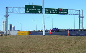
The motorway proceeds south-east through the suburbs of the North Shore, with interchanges at Upper Harbour Highway, Tristram Avenue, Northcote Road, and Esmonde Road allowing access to the suburbs. The Upper Harbour Highway interchange is the northern terminus of the incomplete Western Ring Route
Western Ring Route
The Western Ring Route is a motorway system being constructed in Auckland, New Zealand. It runs along three existing state highways: the Southwestern Motorway , the Northwestern Motorway and the Upper Harbour Highway . When finished it will surpass the Southern Motorway to become the longest...
, which in future will provide an alternative north–south motorway route for traffic travelling through Auckland.
At Esmonde Road, the motorway turns south-west to follow the northern shore of the Waitemata Harbour
Waitemata Harbour
The quite famous Waitemata Harbour is the main access by sea to Auckland, New Zealand. For this reason it is often referred to as Auckland Harbour, despite the fact that it is only one of two harbours surrounding the city, and is crossed by the Auckland Harbour Bridge. The Waitemata forms the north...
to Northcote Point, where the motorway crosses the harbour over the Auckland Harbour Bridge
Auckland Harbour Bridge
The Auckland Harbour Bridge is an eight-lane box truss motorway bridge over the Waitemata Harbour, joining St Marys Bay in Auckland with Northcote in North Shore City, New Zealand. The bridge is part of State Highway 1 and the Auckland Northern Motorway...
. The Harbour Bridge has a contraflow system
Reversible lane
A reversible lane , called a counterflow lane or contraflow lane in transport engineering nomenclature, is a lane in which traffic may travel in either direction, depending on certain conditions...
on it which allows five lanes southbound and three northbound during morning rush hour, five lanes northbound and three southbound during evening rush hour, and four lanes each way at other times. The lanes are separated by a moveable median barrier.
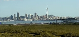
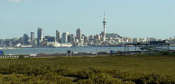
Coming off the Harbour Bridge, the road turns sharply to head eastwards towards the Auckland city centre
Auckland CBD
The Auckland CBD is the geographical and economic heart of the Auckland metropolitan area. Bounded by several major motorways and by the harbour coastline in the north, it is surrounded further out by mostly suburban areas...
. An interchange with Fanshawe Street allows motorway traffic to access the northern end of the city centre, and also allows lanes to be dropped ahead of the narrow four-lane Victoria Park Viaduct
Victoria Park Viaduct
The Victoria Park Viaduct is a major motorway viaduct carrying the Auckland Northern Motorway over the Victoria Park area in Auckland City, New Zealand...
. The motorway then turns south-east across the Victoria Park Viaduct, and travels down the western side of the city centre, with an exit at Cook Street to allow access to the southern end of the city centre.
The motorway emerges at the top of the Central Motorway Junction
Central Motorway Junction
The Central Motorway Junction or CMJ , is the intersection of New Zealand State Highways 1 and 16, just south of the central business district of Auckland, New Zealand...
("Spaghetti Junction"). The Northern Motorway terminates at the exit to the Northwestern Motorway, with the mainline becoming the Southern Motorway
Auckland Southern Motorway
The Auckland Southern Motorway is the major route south out of the Auckland Region of New Zealand. It is part of State Highway 1....
.
Toll
Tolls for the Northern Gateway Toll Road are collected electronically, using an automated toll plaza just north of the Grand Drive interchange. The automated toll plaza uses automatic number plate recognition to identify the vehicle, from which the number plate is optically read and details checked against the New Zealand Transport Agency's (NZTA) database, any pre-payment made or account open for that particular vehicle. Additional sensors detect the size of the vehicle, to help prevent misreads of registration plates and to notice plate swaps between cars and trucks. In the event the computer system needs assistance in recognising plates or needs help for any other reason, data is sent to the NZTA office in Palmerston NorthPalmerston North
Palmerston North is the main city of the Manawatu-Wanganui region of the North Island of New Zealand. It is an inland city with a population of and is the country's seventh largest city and eighth largest urban area. Palmerston North is located in the eastern Manawatu Plains near the north bank...
for human analysis.
Vehicles can pay up to 180 days before travel and up to 5 days after, either at the self-service kiosks located at the Dairy Flat Service Centre for northbound traffic and at a rest stop 1 km north of the beginning of the motorway for southbound traffic, by account, by telephone, or online. If the toll is not paid within five days after travel on the toll road, a payment notice for the toll plus a $4.90 administration fee is sent to the registered owner of the vehicle. If payment is still not received, a $40 toll infringement fine is issued, and is treated the same way as regular traffic infringement.
As of 1 June 2010, the tolls for a single one-way trip on the Northern Gateway Toll Road are:
| Vehicle | Toll |
|---|---|
| Cars, motorcycles, light commercial vehicles (≤3.5 tonne) | $2.00 |
| Heavy commercial vehicles (>3.5 tonne) | $4.00 |
| Caravans/trailers | No extra charge |
From its opening to 31 May 2010, motorcycles travelled on the toll road free of charge.
Each toll costs 78 cents to collect, as of May 2010.
History
The first section of the Northern Motorway opened on 30 May 1959, in conjunction with the opening of the Auckland Harbour Bridge. The first section totalled 7.4 km, stretching from Northcote Road to Fanshawe Street. On its opening day, 51,000 vehicles crossed the Harbour Bridge, with southbound traffic backing up for unprecedented 10 km north of the toll plaza (near the present Stafford Street exit) with vehicles wishing to cross the bridge for the first time. Initially, the Auckland Harbour Bridge Authority owned and operated the motorway between Fanshawe Street and the toll plaza, while the National Roads Board (the predecessor to the New Zealand Transport Agency) operated the remainder of the motorway from the toll plaza to Northcote Road.Initially, the motorway was limited access, with all ramps facing towards the Harbour Bridge. Tolls for the Harbour Bridge were collected manually, with cars initially paying 2/6 to cross the bridge (equal to 25 cents in today's New Zealand dollar
New Zealand dollar
The New Zealand dollar is the currency of New Zealand. It also circulates in the Cook Islands , Niue, Tokelau, and the Pitcairn Islands. It is divided into 100 cents....
, equivalent to $5.00 in 2010 dollars).
In 1962, the Victoria Park Viaduct
Victoria Park Viaduct
The Victoria Park Viaduct is a major motorway viaduct carrying the Auckland Northern Motorway over the Victoria Park area in Auckland City, New Zealand...
opened, and the motorway was extended south from Fanshawe Street, over the viaduct, to Cook Street/Wellington Street. In 1969, the motorway was extended northwards from Northcote Avenue to Tristram Avenue, and the Auckland Harbour Bridge's clip-on lanes opened, widening the bridge from four lanes to eight lanes.
In 1978, the motorway was extended south to meet the Southern Motorway at Nelson Street/Hobson Street. This allowed motorway traffic a clear run from Tristram Avenue to St Stephens, on the northern side of the Bombay Hills.
In 1984, the Northern Motorway was extended northward to Sunset Road, near the present Upper Harbour Highway interchange, with a two-laned expressway continuing from Sunset Road to Albany Highway at Albany Village
Albany, New Zealand
Albany is a northern suburb of Auckland, one of the several cities in northern New Zealand. The name derives from Alba and its Latinisation. It is located to the north of the Waitemata Harbour, 15 kilometres northwest of the Auckland city centre. The suburb is in the Albany ward, one of the...
. The motorway ended at a set of traffic lights on the top of a hill, giving limited visibility to motorway traffic. On 30 March 1984, the last tolls were collected for the Harbour Bridge, making the entire Northern Motorway free of charge from 31 March 1984.
In the 1980s, tidal flow was introduced on the Auckland Harbour Bridge to assist with peak flows on the Northern Motorway between the North Shore and central Auckland. The two central lanes were made reversible to allow a 5+3 split favouring the peak direction (southbound in the morning, northbound in the evening) during peak hours, and 4+4 off-peak. The lanes were controlled by overhead signals, which some motorists on the Motorway ignored and were killed when they collided head-on
Head-on collision
A head-on collision is one where the front ends of two ships, trains, planes or vehicles hit each other, as opposed to a side collision or rear-end collision.-Rail transport:...
with oncoming traffic - between 1 January 1989 and 27 November 1989, some five people died as a result of collisions involving the so-called "suicide lanes". In 1990, a moveable barrier was installed to separate the traffic flows.
The expressway between Sunset Road and Greville Road was upgraded and became a part of the Northern Motorway in 1994. A new interchange was created at Upper Harbour Highway and Constellation Drive to replace the Sunset Road intersection.
The late 1990s saw the construction of the first stages of the Albany to Puhoi Realignment (ALPURT) – a 27 km extension of the Northern Motorway, bypassing Albany Hill and the Hibiscus Coast. The first section, ALPURT A, opened between Greville Road and Silverdale on 20 December 1999. At 13 km in length, it was the longest section of motorway to open at once in New Zealand. At the same time, ALPURT B1, a two-lane expressway between Silverdale and the back of Orewa opened.
In 2006, an upgrade to the Central Motorway Junction saw ramps open between the Northern Motorway and the Northwestern Motorway, and the Northern Motorway and Grafton Gully. Beforehand, traffic travelling from the Northern Motorway to the Northwestern Motorway or Grafton Gully had to exit at Cook Street and travel through local city streets to connect to Waitakere or the Port of Auckland.
ALPURT B2, the Northern Gateway Toll Road, opened on 25 January 2009 between Orewa and Puhoi. The Northern Gateway Toll Road was the first automated toll road in New Zealand, and the first under the authority of the New Zealand Transport Agency
New Zealand Transport Agency
The New Zealand Transport Agency is a New Zealand Crown entity tasked with promoting safe and functional transport by land, including the responsibility for driver and vehicle licensing and investigating rail accidents. It was created on 1 August 2008 by the Land Transport Management Amendment...
. At the same time, ALPURT B1 was upgraded to motorway standard to complete the Northern Motorway from central Auckland to Puhoi.
Northern Busway
Although not technically part of the Northern Motorway, the Northern BuswayNorthern Busway, Auckland
thumb|Passengers boarding a [[MAXX Regional Transport]] Northern Express service operated by [[Ritchies Coachlines]].The Northern Busway is a physically separated busway with dedicated park & ride facilities along State Highway 1 in the north of Auckland, New Zealand, linking the North Shore with...
is closely associated with the motorway. The first section of the 6.2 km bus rapid transit
Bus rapid transit
Bus rapid transit is a term applied to a variety of public transportation systems using buses to provide faster, more efficient service than an ordinary bus line. Often this is achieved by making improvements to existing infrastructure, vehicles and scheduling...
road opened in January 2008, and runs along the eastern side of the motorway between the Constellation Drive interchange and the Esmonde Road interchange. An additional 2.5 km southbound bus lane, opened in 2009, runs from Esmonde Road to the Harbour Bridge. Dedicated ramps connect the busway with the Northern Motorway at Constellation Drive and at the Albany Bus Station near the Oteha Valley Road interchange.
Under Construction
As of July 2010, the following projects are currently under construction:- Auckland Harbour BridgeAuckland Harbour BridgeThe Auckland Harbour Bridge is an eight-lane box truss motorway bridge over the Waitemata Harbour, joining St Marys Bay in Auckland with Northcote in North Shore City, New Zealand. The bridge is part of State Highway 1 and the Auckland Northern Motorway...
Clip-on Strengthening - The Harbour Bridge's clip-on lanes (often dubbed the "Nippon clip-ons") were added in 1969 to double the bridge's capacity. The clip-ons are showing signs of fatigue, and heavy vehicles have been banned from using the outside clip on lanes in each direction. Work is currently underway to strengthen the clip-ons to extend their life by 20–30 years, and is expected to be completed by February 2011, costing NZ$45 million.
- Victoria Park TunnelVictoria Park ViaductThe Victoria Park Viaduct is a major motorway viaduct carrying the Auckland Northern Motorway over the Victoria Park area in Auckland City, New Zealand...
- Victoria Park is currently crossed by a narrow four-lane viaduct, which creates a bottleneck for traffic travelling between the Auckland Harbour Bridge and the Central Motorway Junction. Construction of a 440 m long cut-and-cover tunnel to the west of the existing viaduct began in January 2010. Once this is completed in 2012 the tunnel will carry three lanes of northbound traffic, while southbound traffic will use the four lanes of the existing viaduct. In addition, works are being carried out to allow connection between the Auckland Harbour Bridge and the new tunnel and existing viaduct - widening the road to ten lanes total and extending the Harbour bridge moveable median barrier to Fanshawe Street. The project is estimated to cost NZ$430 million, and was fast-tracked by the New Zealand Government in March 2009 as one of its seven "Roads of National Significance" projects.
Proposed
Several other major projects are proposed for the Northern Motorway in the future. From south to north they are:-- Second Harbour Crossing - A second crossing over the Waitemata Harbour between the Esmonde Road intercahnge and the Central Motorway Junction is under investigation to supersede or completely replace the existing Auckland Harbour Bridge. The currently preferred alignment is from the Onewa Road interchange straight across the harbour to the Western ReclamationWestern ReclamationThe Wynyard Quarter is a reclaimed piece of land on the Waitemata Harbour at the western edge of the Auckland waterfront, New Zealand....
, then to the existing motorway near the Cook Street Interchange. The preferred crossing is quadruple tunnels, with two tunnels for general traffic and two for public transport, with pedestrians and cyclists using the existing bridge, but a bridge option in also under consideration. If the second crossing proceeds to construction stage, the project is estimated to cost up to NZ$4 billion.
- SH1-SH18 Motorway Interchange - Currently the Upper Harbour Motorway (State Highway 18) and the planned Western Ring RouteWestern Ring RouteThe Western Ring Route is a motorway system being constructed in Auckland, New Zealand. It runs along three existing state highways: the Southwestern Motorway , the Northwestern Motorway and the Upper Harbour Highway . When finished it will surpass the Southern Motorway to become the longest...
connect with the Northern Motorway at the Constellation Interchange. As a full diamond configuration interchange controlled by traffic lights, this will be the only section of the Upper Harbour Motorway after 2012, and eventually the Western Ring Route, that is not to a motorway standard. The New Zealand Transport Agency is currently looking at upgrading this interchange, with investigation completed by 2010-2011.
- Penlink - A planned link road between SH1 and the Whangaparoa Peninsula. This road would connect with the Northern Motorway at a new interchange near Redvale. This road was originally planned as a toll road by the Rodney District Council. In 2008 the New Zealand Government announced that Penlink would be fully funded by a new regional fuel tax. However in 2009 this decision was reversed, making the project currently uncertain.
- Puhoi to Wellsford - A 34 km four-lane motorway or expressway from the current terminus of the Northern Motorway at Puhoi to north to Wellsford. Much of the route would require a substantial realignment of the present SH1, and would bypass Warkworth to the west. This project is currently at the investigation stage, and could be progressed in stages. Part or all of this road may be tolled. The project is one of the seven "Roads of National Significance" announced by the Government in March 2009. The Puhoi-Wellsford route has proven to be particularly controversial, with critics, including financial commentators and public transport advocates, labelling it the "Holiday Highway" and pointing to a poor benefit-cost ratio. http://www.stuff.co.nz/sunday-star-times/business/4366408/Going-down-the-wrong-road http://www.bettertransport.org.nz/2010/12/1488/
Interchanges
| Territorial authority | Location | km | # Exit number An exit number is a number assigned to a road junction, usually an exit from a freeway. It is usually marked on the same sign as the destinations of the exit, as well as a sign in the gore.... |
Destinations | Notes | |
|---|---|---|---|---|---|---|
| Current | New (from 1 Nov 2010) | |||||
| Rodney District Rodney District The Rodney District of New Zealand was a local government area in the northernmost part in New Zealand's Auckland Region, created in 1989 from the amalgamation of Helensville Borough and Rodney County. The seat of the district council is at Orewa, and the district includes Kawau Island to the... |
Auckland Auckland Council The Auckland Council is the council for the Auckland Region in New Zealand. It began operating on 1 November 2010, combining the functions of the existing regional council and the region's seven previous city and district councils into one "super council" or "super city" governed by a mayor, 20... — Rodney Board |
Puhoi | 388 |  SH 1 North — Warkworth SH 1 North — WarkworthWarkworth Warkworth may refer to:*Warkworth, Northamptonshire, England*Warkworth, Northumberland, England* Warkworth Castle* Warkworth Hermitage*Warkworth, Ontario, Canada*Warkworth, New South Wales, Australia*Warkworth, New Zealand*John Warkworth... , Whangarei Whangarei Whangarei, pronounced , is the northernmost city in New Zealand and the regional capital of Northland Region. Although commonly classified as a city, it is officially part of the Whangarei District, administered by the Whangarei District Council a local body created in 1989 to administer both the... |
Toll cash-payment point for southbound traffic Northern Motorway ends |
|
 SH 17 SH 17New Zealand State Highway 17 State Highway 17 is a 32 kilometre stretch of highway in the North Island of New Zealand. It links State Highway 1 at Puhoi and State Highway 1 at Albany... — Auckland (via Waiwera) |
Southbound exit and northbound entrance Non-motorway traffic route and toll-free route south |
|||||
| Auckland Auckland Council The Auckland Council is the council for the Auckland Region in New Zealand. It began operating on 1 November 2010, combining the functions of the existing regional council and the region's seven previous city and district councils into one "super council" or "super city" governed by a mayor, 20... — Rodney, New Zealand/Hibiscus Hibiscus Coast The Hibiscus Coast is a stretch of the Hauraki Gulf coast located in New Zealand's Rodney District, 10 minutes north of the former North Shore City by car. It contains the northernmost part of the Auckland metropolitan area.... and Bays East Coast Bays East Coast Bays is the collective name for a series of small suburbs of North Shore City, in the Auckland metropolitan area of New Zealand, which line the northeast coast of the city along the shore of the Hauraki Gulf and Rangitoto Channel... Boards |
Orewa | Automated toll point | ||||
| 394 | Grand Drive — Orewa | |||||
| Silverdale | 398.0 | 398 | SH 17 New Zealand State Highway 17 State Highway 17 is a 32 kilometre stretch of highway in the North Island of New Zealand. It links State Highway 1 at Puhoi and State Highway 1 at Albany... — Silverdale Silverdale, Auckland Silverdale is a village approximately 30km north of Auckland in the North Island of New Zealand. It is located on the north bank of the Weiti River and lies to the west of the Whangaparaoa Peninsula... |
Toll-free route north 36.625172°N 174.662876°W |
||
| Dairy Flat | 401.9 |   Dairy Flat Service Centre Dairy Flat Service Centre |
Toll cash-payment point for northbound traffic 36.659434°N 174.667511°W |
|||
| North Shore City | Auckland Auckland Council The Auckland Council is the council for the Auckland Region in New Zealand. It began operating on 1 November 2010, combining the functions of the existing regional council and the region's seven previous city and district councils into one "super council" or "super city" governed by a mayor, 20... — Upper Harbour Board |
Albany North | 409.9 | 410 | Route 29 Oteha Valley Road — North Harbour Stadium North Harbour Stadium North Harbour Stadium is a stadium, situated in Albany, in North Shore City, in New Zealand. It was opened in 1997, after nearly a decade of discussion, planning and construction. Rugby union, football and rugby League are the only sports played on the main ground, as it is rectangular in shape.... , Albany Albany, New Zealand Albany is a northern suburb of Auckland, one of the several cities in northern New Zealand. The name derives from Alba and its Latinisation. It is located to the north of the Waitemata Harbour, 15 kilometres northwest of the Auckland city centre. The suburb is in the Albany ward, one of the... |
|
| Rosedale | 411.8 | 412 | SH 17 New Zealand State Highway 17 State Highway 17 is a 32 kilometre stretch of highway in the North Island of New Zealand. It links State Highway 1 at Puhoi and State Highway 1 at Albany... /Route 25 Greville Road — Browns Bay Browns Bay, New Zealand Browns Bay is an Auckland suburb. It is one of the East Coast Bays suburbs, and is well known for its shops and beaches.Browns Bay is under the local governance of the Auckland Council, and is located in the North Shore ward of the new Auckland city, one of the thirteen newly amalgamated... , Massey University, Albany Albany, New Zealand Albany is a northern suburb of Auckland, one of the several cities in northern New Zealand. The name derives from Alba and its Latinisation. It is located to the north of the Waitemata Harbour, 15 kilometres northwest of the Auckland city centre. The suburb is in the Albany ward, one of the... |
36.735961°N 174.718087°W | ||
| Meadowood | 414.0 | 414 |  SH 18 SH 18New Zealand State Highway 18 State Highway 18 is a State Highway linking North Shore City and Waitakere City in Auckland, New Zealand. It is the northern part of the Western Ring Route... Upper Harbour Highway — Greenhithe Greenhithe, New Zealand Greenhithe is an Auckland suburb. As from 1 November 2010, Greenhithe is under the governance of the Auckland Council.According to the 2001 census, Greenhithe had a population of 4,170. Greenhithe has however shown dramatic growth since the North Shore City Council determined that Greenhithe was to... , Waitakere Waitakere Waitakere City was the name of a city which existed from 1989 until 2010 in the Auckland region. It was New Zealand's fifth largest city, with an annual growth of about 2%... , Mairangi Bay Mairangi Bay Mairangi Bay is a suburb in North Shore City in New Zealand, across the Waitemata Harbour from Auckland.Mairangi Bay is under the local governance of the North Shore City Council... |
36.750800°N 174.726000°W | ||
| Auckland Auckland Council The Auckland Council is the council for the Auckland Region in New Zealand. It began operating on 1 November 2010, combining the functions of the existing regional council and the region's seven previous city and district councils into one "super council" or "super city" governed by a mayor, 20... — Kaipatiki/Devonport Devonport, New Zealand Devonport is a harbourside suburb of Auckland, New Zealand. It is located on the North Shore, at the southern end of a peninsula that runs southeast from near Lake Pupuke in Takapuna, forming the northern side of the Waitemata Harbour... -Takapuna Takapuna Takapuna is a central, coastal suburb of North Shore City, located in the northern North Island of New Zealand, at the beginning of a south-east-facing peninsula forming the northern side of the Waitemata Harbour... Ward |
Forrest Hill | 416.8 | 417 | Route 21 Tristram Ave — Wairau Park, Wairau Valley Wairau Valley, Auckland Wairau Valley is a suburb of North Shore, one of several cities in the Auckland metropolitan area in northern New Zealand. The area is predominantly light industrial/commercial. New Zealand State Highway 1 passes to the east and the Wairau Park shopping complex extends to the north... , Glenfield Glenfield, New Zealand Glenfield is a suburb of North Shore, one of several cities in the Auckland metropolitan area in northern New Zealand. It is located to the north of the Waitemata Harbour, nine kilometres northwest of the Auckland city centre.... , Forrest Hill Forrest Hill, New Zealand Forrest Hill is a suburb of Auckland .Forrest Hill is under the local governance of the North Shore City Council. The population was 5,283 in the 2006 Census, an increase of 372 from 2001.-Association football:... |
||
| Northcote | 418.8 | 419 | Northcote Road — Northcote Northcote, New Zealand Northcote is a suburb of North Shore City, one of several cities in the Auckland metropolitan area in northern New Zealand. It is located on the north shore of the Waitemata Harbour, four kilometres northwest of the Auckland city centre.... , North Shore Hospital North Shore Hospital North Shore Hospital is a large public hospital in Takapuna, North Shore City, serving the northern part of the Auckland area. Located on Shakespeare Road near Lake Pupuke, it is administered by the Waitemata District Health Board, serving around 47,000 people a year.-Facilities:The hospital... , Milford Milford, New Zealand Milford is a suburb of Auckland, New Zealand's largest city. Located on Auckland's North Shore and part of North Shore City, Milford is located on the northern side of Lake Pupuke. It also has a popular swimming beach, which runs some two kilometers from Black Rock in the south to Castor Bay in the... |
|||
| Akoranga | 420.3 | 420 | Route 26 Esmonde Road — Takapuna Takapuna Takapuna is a central, coastal suburb of North Shore City, located in the northern North Island of New Zealand, at the beginning of a south-east-facing peninsula forming the northern side of the Waitemata Harbour... , Devonport Devonport, New Zealand Devonport is a harbourside suburb of Auckland, New Zealand. It is located on the North Shore, at the southern end of a peninsula that runs southeast from near Lake Pupuke in Takapuna, forming the northern side of the Waitemata Harbour... , AUT University |
|||
| Auckland Auckland Council The Auckland Council is the council for the Auckland Region in New Zealand. It began operating on 1 November 2010, combining the functions of the existing regional council and the region's seven previous city and district councils into one "super council" or "super city" governed by a mayor, 20... — Kaipatiki Board |
Northcote | 422.0 | 421 | Route 27 Onewa Road — Northcote Northcote, New Zealand Northcote is a suburb of North Shore City, one of several cities in the Auckland metropolitan area in northern New Zealand. It is located on the north shore of the Waitemata Harbour, four kilometres northwest of the Auckland city centre.... , Birkenhead Birkenhead, New Zealand Birkenhead is a suburb of Auckland, in northern New Zealand. It is located on the north shore of the Waitemata Harbour, four kilometres northwest of the Auckland city centre.... |
||
| 422.9 | 422 | Stafford Road | Northbound exit only | |||
| Northcote Point | 423.2 |  Auckland Harbour Bridge Auckland Harbour BridgeAuckland Harbour Bridge The Auckland Harbour Bridge is an eight-lane box truss motorway bridge over the Waitemata Harbour, joining St Marys Bay in Auckland with Northcote in North Shore City, New Zealand. The bridge is part of State Highway 1 and the Auckland Northern Motorway... over Waitemata Harbour Waitemata Harbour The quite famous Waitemata Harbour is the main access by sea to Auckland, New Zealand. For this reason it is often referred to as Auckland Harbour, despite the fact that it is only one of two harbours surrounding the city, and is crossed by the Auckland Harbour Bridge. The Waitemata forms the north... |
36.830447°N 174.740553°W | |||
| Auckland City Auckland City Auckland City was the city and local authority covering the Auckland isthmus and most of the islands of the Hauraki Gulf, in the North Island of New Zealand. On 1 November 2010 it was amalgamated into the wider Auckland Region under the authority of the new Auckland Council... |
Auckland Auckland Council The Auckland Council is the council for the Auckland Region in New Zealand. It began operating on 1 November 2010, combining the functions of the existing regional council and the region's seven previous city and district councils into one "super council" or "super city" governed by a mayor, 20... — Waitemata Waitemata Waitemata can be:*Waitemata Harbour, a large bay in New Zealand*Waitemata City, a local government body on the shores of Waitemata Harbour, now part of Waitakere.... Board |
|||||
| St Mary's Bay | 425.0 | 423 | Shelly Beach Road — Ponsonby Ponsonby, New Zealand Ponsonby is an inner-city suburb of Auckland City located 2 km west of the Auckland CBD, in the North Island of New Zealand. The suburb is oriented along a ridge running north-south, which is followed by the main street of the suburb, Ponsonby Road.... , Herne Bay Herne Bay, New Zealand Herne Bay is a suburb of Auckland, New Zealand. It is located on the southwestern shore of the Waitemata Harbour to the west of the Auckland Harbour Bridge.Herne Bay is under the local governance of the Auckland City Council.... |
Southbound exit and northbound entrance | ||
| Auckland CBD | 426.2 | 424 | Route 6 Fanshawe Street — City Centre (North) | Southbound exit and northbound entrance | ||
| 426.6 | Victoria Park Viaduct Victoria Park Viaduct The Victoria Park Viaduct is a major motorway viaduct carrying the Auckland Northern Motorway over the Victoria Park area in Auckland City, New Zealand... |
36.847045°N 174.753095°W | ||||
| 427.0 | 425 | Cook Street — City Centre (South) | Southbound exit and northbound entrance (via Wellington Street) | |||
| 427.2 | 426A |  SH 16 SH 16New Zealand State Highway 16 State Highway 16 is a New Zealand state highway linking Auckland City with Wellsford, via Auckland's Northwestern Motorway, Helensville and Kaukapakapa... Northwest Motorway Northwest Motorway The Northwestern Motorway , part of State Highway 16 , is the major western route and secondary northern route out of Auckland in New Zealand... east — Port |
Southbound exit and northbound entrance | |||
| 426B | SH 16 New Zealand State Highway 16 State Highway 16 is a New Zealand state highway linking Auckland City with Wellsford, via Auckland's Northwestern Motorway, Helensville and Kaukapakapa... Northwest Motorway Northwest Motorway The Northwestern Motorway , part of State Highway 16 , is the major western route and secondary northern route out of Auckland in New Zealand... west — Waitakere Waitakere Waitakere City was the name of a city which existed from 1989 until 2010 in the Auckland region. It was New Zealand's fifth largest city, with an annual growth of about 2%... , Helensville |
Southbound exit and northbound entrance | ||||
| 427.0 | SH 1 Southern Motorway Auckland Southern Motorway The Auckland Southern Motorway is the major route south out of the Auckland Region of New Zealand. It is part of State Highway 1.... south — Manukau South Auckland South Auckland is an imprecisely defined area of Auckland, New Zealand, often stereotyped as a socio-economically disadvantaged, and sometimes rough, urban area with a relatively large Polynesian and Māori population. The name South Auckland is not an official place name but is in common use by New... , Hamilton Hamilton, New Zealand Hamilton is the centre of New Zealand's fourth largest urban area, and Hamilton City is the country's fourth largest territorial authority. Hamilton is in the Waikato Region of the North Island, approximately south of Auckland... |
Northern Motorway ends | ||||
distance rounds down to 427 at the beginning of the Southern Motorway.