

Tropical cyclone observation
Encyclopedia
Tropical cyclone observation has been carried out over the past couple of centuries in various ways. The passage of typhoons, hurricanes, as well as other tropical cyclones have been detected by word of mouth from sailors recently coming to port or by radio transmissions from ships at sea, from sediment deposits in near shore estuaries, to the wiping out of cities near the coastline. Since World War II
World War II
World War II, or the Second World War , was a global conflict lasting from 1939 to 1945, involving most of the world's nations—including all of the great powers—eventually forming two opposing military alliances: the Allies and the Axis...
, advances in technology have included using planes to survey the ocean basins, satellites to monitor the world's oceans from outer space
Outer space
Outer space is the void that exists between celestial bodies, including the Earth. It is not completely empty, but consists of a hard vacuum containing a low density of particles: predominantly a plasma of hydrogen and helium, as well as electromagnetic radiation, magnetic fields, and neutrinos....
using a variety of methods, radars to monitor their progress near the coastline, and recently the introduction of unmanned aerial vehicles to penetrate storms. Recent studies have concentrated on studying hurricane impacts lying within rocks or near shore lake sediments, which are branches of a new field known as paleotempestology
Paleotempestology
Paleotempestology is the study of past tropical cyclone activity by means of geological proxies as well as historical documentary records. The term was coined by Kerry Emanuel.-Sedimentary proxy records:...
. This article details the various methods employed in the creation of the hurricane database, as well as reconstructions necessary for reanalysis of past storms used in projects such as the Atlantic hurricane reanalysis
Atlantic hurricane reanalysis
Atlantic hurricane reanalysis is an ongoing project within the National Oceanic and Atmospheric Administration which seeks to correct and add new information about past Atlantic tropical cyclones...
.
Stalagmites in caves
Recent studies of the 18OOxygen-18
Oxygen-18 is a natural, stable isotope of oxygen and one of the environmental isotopes.18O is an important precursor for the production of fluorodeoxyglucose used in positron emission tomography...
and 13C
Carbon-13
Carbon-13 is a natural, stable isotope of carbon and one of the environmental isotopes. It makes up about 1.1% of all natural carbon on Earth.- Detection by mass spectrometry :...
isotopes found in stalagmite
Stalagmite
A stalagmite is a type of speleothem that rises from the floor of a limestone cave due to the dripping of mineralized solutions and the deposition of calcium carbonate. This stalagmite formation occurs only under certain pH conditions within the underground cavern. The corresponding formation on...
s in Belize
Belize
Belize is a constitutional monarchy and the northernmost country in Central America. Belize has a diverse society, comprising many cultures and languages. Even though Kriol and Spanish are spoken among the population, Belize is the only country in Central America where English is the official...
show that tropical cyclone events can leave markers that can be separated out on a week-by-week basis. The error rate of this type of microanalysis was 1 error in 1,200 sampling points.
Markers in coral
Rocks contain certain isotopes of elements, known as natural tracers, which describe the conditions under which they formed. By studying the calcium carbonate in coral rock, past sea surface temperature and hurricane information can be revealed. Lighter oxygen isotopes (18O) are left behind in coral during periods of very heavy rainfall. Since hurricanes are the main source of extreme rainfall in the tropical oceans, past hurricane events can be dated to the days of their impact on the coral by looking at the increased 18O concentration within the coral.Sediment deposition in coastal lakes
Kam Biu-Liu, a professor at Louisiana State UniversityLouisiana State University
Louisiana State University and Agricultural and Mechanical College, most often referred to as Louisiana State University, or LSU, is a public coeducational university located in Baton Rouge, Louisiana. The University was founded in 1853 in what is now known as Pineville, Louisiana, under the name...
, has been studying sediment lying at the bottom of coastal lakes and marshes in order to study the frequency and intensity of hurricanes over the past 5,000 years. Since storm surges sweep coastal sands with them as they progress inland, a layer of sand is left behind in coastal lakes and marshes. Radiocarbon dating
Radiocarbon dating
Radiocarbon dating is a radiometric dating method that uses the naturally occurring radioisotope carbon-14 to estimate the age of carbon-bearing materials up to about 58,000 to 62,000 years. Raw, i.e. uncalibrated, radiocarbon ages are usually reported in radiocarbon years "Before Present" ,...
is then used to date the layers.
Newspapers
Before the invention of the telegraph in the early to mid 19th century, news was as fast as the quickest horse, stage, or ship. Normally, there was no advance warning of a tropical cyclone impact. However, the situation changed in the 19th century as sea-faring people and land-based researchers, such as Father Viñes in CubaCuba
The Republic of Cuba is an island nation in the Caribbean. The nation of Cuba consists of the main island of Cuba, the Isla de la Juventud, and several archipelagos. Havana is the largest city in Cuba and the country's capital. Santiago de Cuba is the second largest city...
, came up with systematic methods of reading the sky's appearance or the sea state, which could foretell a tropical cyclone's approach up to a couple days in advance.
In China
China
Chinese civilization may refer to:* China for more general discussion of the country.* Chinese culture* Greater China, the transnational community of ethnic Chinese.* History of China* Sinosphere, the area historically affected by Chinese culture...
, the abundance of historical documentary records in the form of (semiofficial local gazettes) offers an extraordinary opportunity for providing a high-resolution historical dataset for the frequency of typhoon strikes. Kam-biu Liu et al. (2001) reconstructed a 1,000-year time series of typhoon landfalls in the Guangdong Province of southern China since AD 975 and found that on a decadal timescale, the twenty-year interval from AD 1660 to 1680 is the most active period on record, with twenty-eight to thirty-seven typhoon landfalls per decade. The variability in typhoon landfalls in Guangdong mimics that observed in other paleoclimatic proxies (e.g., tree rings, ice cores) from China and the northern hemisphere. Remarkably, the two periods of most frequent typhoon strikes in Guangdong (AD 1660-1680, 1850–1880) coincide with two of the coldest and driest periods in northern and central China during the Little Ice Age
Little Ice Age
The Little Ice Age was a period of cooling that occurred after the Medieval Warm Period . While not a true ice age, the term was introduced into the scientific literature by François E. Matthes in 1939...
.
Surface observations
Ship reports
For centuries, people have sailed the world's oceans and seas, and for just as long, they have encountered storms. The worst of the cyclones over the open seas likely took those that observed them into the depths of the oceans. However, some did survive to report harrowing tales. Before the invention of the wireless telegraph in 1905, reports about storms at sea either coincided with their arrival at the coast as ships scrambled into port, or came weeks and months afterwards from remote ports of call. Ship and buoy reports, available since the 1970s, are used in real-time not only for their temperature, pressure, and wind measurements, but also for their sea surface temperature and wave height measurements.Wind reports from ships at sea have become increasingly based on anemometers, and less so on the Beaufort Scale
Beaufort scale
The Beaufort Scale is an empirical measure that relates wind speed to observed conditions at sea or on land. Its full name is the Beaufort Wind Force Scale.-History:...
. This is important to note as the Beaufort Scale underestimates winds at higher wind speeds, indicating ship wind observations taken for older storms are likely to underrepresent their true value.
As Christopher Landsea
Christopher Landsea
Christopher W. Landsea is an American meteorologist, formerly a research meteorologist with Hurricane Research Division of Atlantic Oceanographic & Meteorological Laboratory at NOAA, and now the Science and Operations Officer at the National Hurricane Center...
et al. point out, many tropical cyclones that formed on the open sea and did not affect any coast usually went undetected prior to satellite observation since the 1970s. They estimated an undercount bias of zero to six tropical cyclones per year between 1851 and 1885 and zero to four per year between 1886 and 1910. These undercounts roughly take into account the typical size of tropical cyclones, the density of shipping tracks over the Atlantic basin, and the amount of populated coastline.
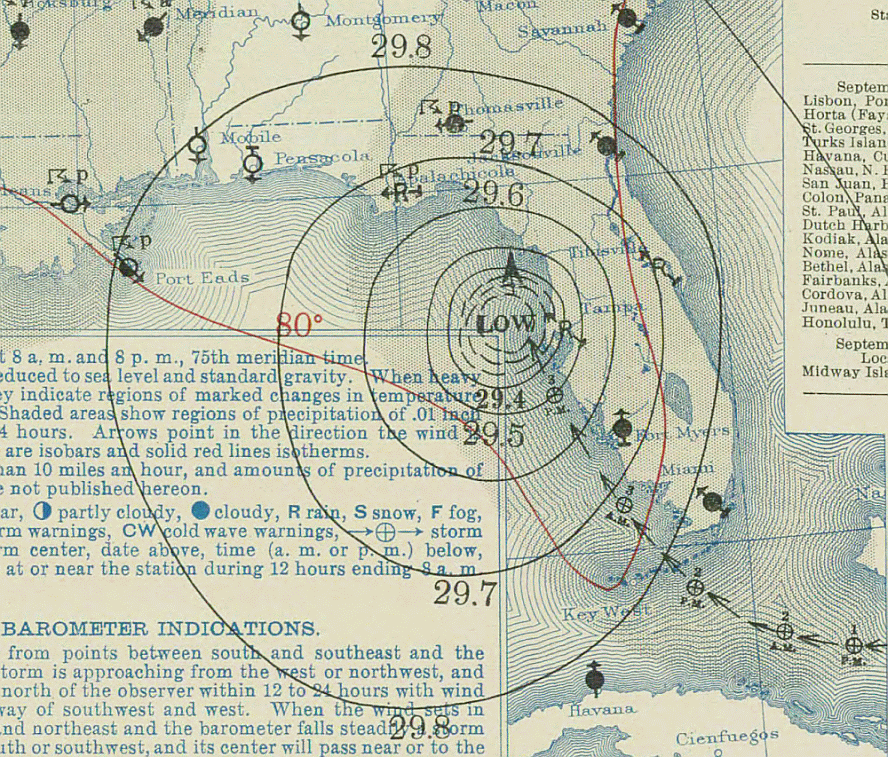
Land-based observations
In the early 20th century, forecasting the track of cyclones was still confined to areas of the greatest surface pressure falls, based upon surface weather observationSurface weather observation
Surface weather observations are the fundamental data used for safety as well as climatological reasons to forecast weather and issue warnings worldwide. They can be taken manually, by a weather observer, by computer through the use of automated weather stations, or in a hybrid scheme using...
s, and climatology. These methods proved to be the cutting edge of tropical cyclone forecasting through the mid 20th century. Land-based surface observations remain invaluable as a source of real-time information at locations near the coastline and inland. Combined with ship observations and newspapers, they formed the total information network for hurricane detection until radiosondes were introduced in 1941 and reconnaissance aircraft began in 1944. Land-based observations of pressure and wind can show how quickly a tropical cyclone is decaying as it moves inland. Their rainfall reports show where significant rainfall is occurring, and can be an alert for possible flooding. With the establishment of the ASOS network in the United States
United States
The United States of America is a federal constitutional republic comprising fifty states and a federal district...
during the 1990s, more locations are reporting around the clock than ever before.
Mobile platforms
Since the 1990s, academic researchers have begun to deploy mobile weather stations fortified to withstand hurricane-force winds. The two largest programs are the Florida Coastal Monitoring Program and the Wind Engineering Mobile Instrumented Tower Experiment. During landfall, the NOAA Hurricane Research Division compares and verifies data from reconnaissance aircraft, including wind speed data taken at flight level and from GPS dropwindsondes and stepped-frequency microwave radiometers, to wind speed data transmitted in real time from weather stations erected near or at the coast. The National Hurricane Center uses the data to evaluate conditions at landfall and to verify forecasts.Reconnaissance aircraft
The idea of aircraft reconnaissance of tropical cyclones first was put forth by Captain W. L. Farnsworth of the Galveston Commercial Association in the early 1930s. Supported by the United States Weather Bureau, it passed both the United States SenateUnited States Senate
The United States Senate is the upper house of the bicameral legislature of the United States, and together with the United States House of Representatives comprises the United States Congress. The composition and powers of the Senate are established in Article One of the U.S. Constitution. Each...
and United States House of Representatives
United States House of Representatives
The United States House of Representatives is one of the two Houses of the United States Congress, the bicameral legislature which also includes the Senate.The composition and powers of the House are established in Article One of the Constitution...
in 1936. Since 1944, aircraft have been flying out to sea to find tropical cyclones. Before regular satellite coverage, this was a hit-or-miss affair. Thereafter, aircraft flights into tropical systems became more targeted and precise. Nowadays, a C-130 is used as a hurricane hunter by the Air Force, while the P-3 Orion is used by the National Oceanic and Atmospheric Administration
National Oceanic and Atmospheric Administration
The National Oceanic and Atmospheric Administration , pronounced , like "noah", is a scientific agency within the United States Department of Commerce focused on the conditions of the oceans and the atmosphere...
for research projects used to better understand tropical cyclone
Tropical cyclone
A tropical cyclone is a storm system characterized by a large low-pressure center and numerous thunderstorms that produce strong winds and heavy rain. Tropical cyclones strengthen when water evaporated from the ocean is released as the saturated air rises, resulting in condensation of water vapor...
s and improve hurricane forecasts.
The implementation of synoptic observation missions by a Gulfstream jet, where dropwinsondes are used to investigate a tropical cyclone's environment, has led to a 15-20 percent reduction in track forecast errors where such missions were present.
Historical aircraft used for weather and hurricane tracking include:
- RK-47B-47 StratojetThe Boeing Model 450 B-47 Stratojet was a long-range, six-engined, jet-powered medium bomber built to fly at high subsonic speeds and at high altitudes. It was primarily designed to drop nuclear bombs on the Soviet Union...
USAF - WB-29B-29 SuperfortressThe B-29 Superfortress is a four-engine propeller-driven heavy bomber designed by Boeing that was flown primarily by the United States Air Forces in late-World War II and through the Korean War. The B-29 was one of the largest aircraft to see service during World War II...
USAF - WB-57FB-57 CanberraThe Martin B-57 Canberra was a United States-built, twin jet engine light bomber and reconnaissance aircraft, which entered service with the United States Air Force in 1953. The B-57 was initially a version of the English Electric Canberra built under license. However, the Glenn L...
- NASANASAThe National Aeronautics and Space Administration is the agency of the United States government that is responsible for the nation's civilian space program and for aeronautics and aerospace research... - B-50B-57 CanberraThe Martin B-57 Canberra was a United States-built, twin jet engine light bomber and reconnaissance aircraft, which entered service with the United States Air Force in 1953. The B-57 was initially a version of the English Electric Canberra built under license. However, the Glenn L...
USAF - WB-50DB-57 CanberraThe Martin B-57 Canberra was a United States-built, twin jet engine light bomber and reconnaissance aircraft, which entered service with the United States Air Force in 1953. The B-57 was initially a version of the English Electric Canberra built under license. However, the Glenn L...
USAF - WC-135BWC-135 Constant PhoenixThe WC-135 Constant Phoenix is a special purpose aircraft derived from the Boeing C-135 and used by the United States Air Force. Its mission is to collect samples from the atmosphere for the purpose of detecting and identifying nuclear explosions...
USAF - WC-130 USAF
In Canada
Canada
Canada is a North American country consisting of ten provinces and three territories. Located in the northern part of the continent, it extends from the Atlantic Ocean in the east to the Pacific Ocean in the west, and northward into the Arctic Ocean...
, the Convair 580 is used by National Research Council to track hurricanes.
Unmanned aerial vehicles
The era of the aerosonde began in 1998, when the AustraliaAustralia
Australia , officially the Commonwealth of Australia, is a country in the Southern Hemisphere comprising the mainland of the Australian continent, the island of Tasmania, and numerous smaller islands in the Indian and Pacific Oceans. It is the world's sixth-largest country by total area...
n Bureau of Meteorology
Bureau of Meteorology
The Bureau of Meteorology is an Executive Agency of the Australian Government responsible for providing weather services to Australia and surrounding areas. It was established in 1906 under the Meteorology Act, and brought together the state meteorological services that existed before then...
flew an aerosonde into Tropical Cyclone Tiffany. In 2005, Hurricane Ophelia became the first Atlantic tropical cyclone
Tropical cyclone
A tropical cyclone is a storm system characterized by a large low-pressure center and numerous thunderstorms that produce strong winds and heavy rain. Tropical cyclones strengthen when water evaporated from the ocean is released as the saturated air rises, resulting in condensation of water vapor...
where an unmanned aerial vehicle, known as an aerosonde, mission was used for a tropical cyclone
Tropical cyclone
A tropical cyclone is a storm system characterized by a large low-pressure center and numerous thunderstorms that produce strong winds and heavy rain. Tropical cyclones strengthen when water evaporated from the ocean is released as the saturated air rises, resulting in condensation of water vapor...
. The first typhoon was penetrated by an aerosonde in 2005 as well. Unlike normal reconnaissance flights, the aerosonde stayed near the surface after a 10-hour flight within the tropical cyclone.
Radar

During World War II
World War II
World War II, or the Second World War , was a global conflict lasting from 1939 to 1945, involving most of the world's nations—including all of the great powers—eventually forming two opposing military alliances: the Allies and the Axis...
, radar
Radar
Radar is an object-detection system which uses radio waves to determine the range, altitude, direction, or speed of objects. It can be used to detect aircraft, ships, spacecraft, guided missiles, motor vehicles, weather formations, and terrain. The radar dish or antenna transmits pulses of radio...
technology was developed to detect aircraft. It soon became apparent that large areas became obscured when significant weather was in the area. In 1957, the National Weather Service
National Weather Service
The National Weather Service , once known as the Weather Bureau, is one of the six scientific agencies that make up the National Oceanic and Atmospheric Administration of the United States government...
established the United States
United States
The United States of America is a federal constitutional republic comprising fifty states and a federal district...
' first radar network to cover the coastline and act as first warning of an impending tropical cyclone. Upgraded in the 1990s to use doppler technology, radar can provide rainfall estimates, wind estimates, possible locations of tornadoes within a system's spiral bands, as well as the center location of a tropical cyclone.
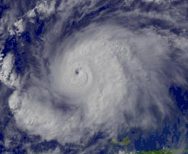
Satellite
Beginning with the launching of TIROS-I in April 1960, satellites have been used to look for tropical cyclones. The Dvorak technique was developed from early satellite images of tropical cyclones to determine real-time a tropical cyclone's strength from characteristics seen on satellite imagery. In most tropical cyclone basins, use of the satellite-based Dvorak techniqueDvorak technique
The Dvorak technique is a widely used system to subjectively estimate tropical cyclone intensity based solely on visible and infrared satellite images. Several agencies issue Dvorak intensity numbers for cyclones of sufficient intensity...
is the primary method used to determine a tropical cyclone's maximum sustained winds. The extent of banding and difference in temperature between the eye and eyewall is used within the technique to assign a maximum sustained wind and pressure. Since the mid 1990s, microwave imagery has been able to determine the center of rotation when that center is obscured by mid to high level cloudiness. Cloud top temperatures are used in real-time to estimate rainfall rates within the cyclone.
 |
 |
 |
 |
| Tropical Storm Wilma Hurricane Wilma Hurricane Wilma was the most intense tropical cyclone ever recorded in the Atlantic basin. Wilma was the twenty-second storm , thirteenth hurricane, sixth major hurricane, and fourth Category 5 hurricane of the record-breaking 2005 season... at T3.0 |
Tropical Storm Dennis Hurricane Dennis Hurricane Dennis was an early-forming major hurricane in the Caribbean and Gulf of Mexico during the very active 2005 Atlantic hurricane season. Dennis was the fourth named storm, second hurricane, and first major hurricane of the season... at T4.0 |
Hurricane Jeanne Hurricane Jeanne Hurricane Jeanne was the deadliest hurricane in the 2004 Atlantic hurricane season. It was the tenth named storm, the seventh hurricane, and the fifth major hurricane of the season, as well as the third hurricane and fourth named storm of the season to make landfall in Florida... at T5.0 |
Hurricane Emily Hurricane Emily (2005) Hurricane Emily was a powerful, early season tropical cyclone that caused significant damage across the Caribbean Sea to Mexico. A Cape Verde-type hurricane, the storm formed on July 10, 2005, in the central Atlantic Ocean before passing through the Windward Islands on July 14... at T6.0 |
See also
- Atlantic hurricane reanalysisAtlantic hurricane reanalysisAtlantic hurricane reanalysis is an ongoing project within the National Oceanic and Atmospheric Administration which seeks to correct and add new information about past Atlantic tropical cyclones...
- Hurricane huntersHurricane HuntersThe Hurricane Hunters are aircraft that fly into tropical cyclones in the North Atlantic Ocean and Northeastern Pacific Ocean for the specific purpose of directly measuring weather data in and around those storms. In the United States, the Air Force, Navy, and NOAA units have all participated in...
- PaleotempestologyPaleotempestologyPaleotempestology is the study of past tropical cyclone activity by means of geological proxies as well as historical documentary records. The term was coined by Kerry Emanuel.-Sedimentary proxy records:...
- Radiocarbon datingRadiocarbon datingRadiocarbon dating is a radiometric dating method that uses the naturally occurring radioisotope carbon-14 to estimate the age of carbon-bearing materials up to about 58,000 to 62,000 years. Raw, i.e. uncalibrated, radiocarbon ages are usually reported in radiocarbon years "Before Present" ,...
- SatelliteSatelliteIn the context of spaceflight, a satellite is an object which has been placed into orbit by human endeavour. Such objects are sometimes called artificial satellites to distinguish them from natural satellites such as the Moon....
- Surface weather analysisSurface weather analysisSurface weather analysis is a special type of weather map that provides a view of weather elements over a geographical area at a specified time based on information from ground-based weather stations...
- Tropical cycloneTropical cycloneA tropical cyclone is a storm system characterized by a large low-pressure center and numerous thunderstorms that produce strong winds and heavy rain. Tropical cyclones strengthen when water evaporated from the ocean is released as the saturated air rises, resulting in condensation of water vapor...