
Tropical Storm Vamei
Encyclopedia
Tropical Storm Vamei was a Pacific
tropical cyclone
that formed closer to the equator
than any other tropical cyclone worldwide. The last storm of the 2001 Pacific typhoon season
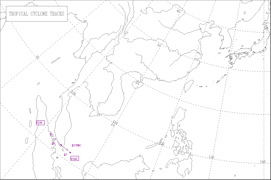
, Vamei developed on December 26 at 1.4° N
in the South China Sea
. It strengthened quickly and made landfall
along extreme southeastern Malaysia. Vamei rapidly dissipated over Sumatra
on December 28, and the remnants eventually re-organized in the North Indian Ocean
.
Though officially designated as a tropical storm, the intensity of Vamei is disputed; some agencies classify it as a typhoon, based on sustained winds of 140 km/h (85 mph) and the appearance of an eye
. The storm brought flooding and landslides to eastern Malaysia, causing $3.6 million in damage (2001 USD
, $ USD) and five deaths.
; at the same time a plume of cold air progressed southward through the South China Sea
on the southeastern periphery of a ridge
over the Far East
. The vortex drifted southwestward, reaching open water by December 21. The northerly air surge was deflected after interacting with the circulation, and at the same time a portion of the air surge crossed the equator
. The southerly flow turned eastward, then northward, and in combination with the northerly flow it wrapped into the vortex, resulting in rapid development
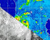
of the low-level circulation, just a short distance north of the equator. By December 25, an area of scattered convection
persisted about 370 km (230 mi) east of Singapore
within an area of low wind shear
, in association with the low-level circulation. Continuing slowly westward, the convection deepened and organized further, and at 1200 UTC
on December 26 the disturbance developed into a tropical depression about 230 km (145 mi) east of Singapore, or 156 km (97 mi) north of the equator. This was the first recorded occurrence of a tropical cyclone near the equator.
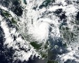
The depression strengthened further and officially attained tropical storm status at 0000 UTC on December 27, based on the analysis by the Japan Meteorological Agency
(JMA), though the Joint Typhoon Warning Center
(JTWC) unofficially classified it as a tropical storm six hours prior. Shortly thereafter, an eye
with a 39 km (24 mi) diameter became apparent on satellite imagery, along with rainbands extending southward to the opposite side of the equator. At 0600 UTC, the JMA first classified the system as Tropical Storm Vamei, about 65 km (40 mi) northeast of Singapore, and the agency estimated the storm attained peak winds of 85 km/h (50 mph) at the same time. However, the JTWC upgraded Vamei to typhoon status with peak winds of 140 km/h (85 mph), based on a United States Navy
ship report from within the eye; a second ship reported wind gusts of 195 km/h (120 mph) in the southern portion of the eyewall. The storm was small and compact, with gales extending about 45 km (30 mi) from its center. At about 0830 UTC on December 27, Vamei made landfall
approximately 60 km (35 mi) northeast of Singapore, in the southeastern portion of the Malaysian state of Johor
. Initially, the Malaysian Meteorological Department
classified the cyclone as a tropical storm, though it was later re-assessed as a typhoon at landfall.
Tropical Storm Vamei weakened quickly as it crossed the extreme southern portion of the Malay Peninsula, and late on December 27 the JMA downgraded it to tropical depression status before the cyclone emerged into the Straits of Malacca. The JTWC initially maintained it as a minimal tropical storm, though the agency downgraded the storm to depression status as the center again approached land. Early on December 28, Vamei moved ashore along northeastern Sumatra
, and at 0600 UTC the JMA classified the storm as dissipated. However, convection persisted near the circulation over land, believed to have been caused by the process known as upper-level diffluence
. On December 29, what was originally believed to be a separate system reached the southeastern Bay of Bengal
. In a post-season re-evaluation, the JTWC classified the system as a continuation of Vamei, based on analysis of satellite imagery that indicated the circulation of Vamei crossed Sumatra without dissipating. Convection re-developed, and late on December 30 the JTWC classified the cyclone as a tropical storm about 390 km (245 mi) west-southwest of the northwestern tip of Sumatra; initially, due to being treated as a separate system, it was classified as Tropical Cyclone 05B. Vamei quickly developed good outflow
and organization, though increased wind shear on December 31 rapidly weakened the storm; by late that day, the center was exposed from the deep convection, and Vamei quickly dissipated.
 Vamei formed and reached tropical storm strength at 1.5º N
, only 156 km (97 mi) from the equator. This broke the previous record of Typhoon Sarah in the 1956 Pacific typhoon season, which reached tropical storm strength at 2.2º N. Due to a lack of Coriolis effect
near the equator, the formation of Vamei was previously considered impossible. However, a study by the Naval Postgraduate School
indicated that the probability for a similar equatorial development was at least once every four centuries.
Vamei developed in a vortex that appears every winter along the northwest coast of Borneo
and is maintained by the interaction between monsoonal winds
and the local topography. Often, the vortex remains near the coastline, and in an analysis of 51 winters, only six reported the vortex as being over the equatorial waters for four days or more. As the area in the South China Sea between Borneo and Singapore is only 665 km (415 mi) wide, a vortex needs to move slowly to develop. A persistent northerly wind surge for more than five days, which is needed to enhance the vortex, is present, on average, nine days each winter. The probability for a pre-existing tropical disturbance to develop into a tropical cyclone is between 10–30 percent. Thus, the conditions which resulted in the formation of Vamei are believed to occur once every 100–400 years.
 Four days prior to Vamei moving ashore, the Malaysian Meteorological Department (MMD) issued storm advisories for potentially affected areas. Subsequently, the agency issued warnings for heavy rainfall, high winds, and rough seas. However, few citizens knew of the passage of the rare storm.
Offshore of Malaysia, two U.S. Navy ships in Vamei's eyewall were damaged by strong winds. Upon moving ashore, the storm brought storm surge
damage to portions of southeastern Malaysia. Vamei brought strong winds and heavy rainfall to portions of Melaka, Negeri Sembilan
, and Selangor
as well as to Johor
, where rainfall reached over 200 mm (8 in) in Senai
. Additionally, monsoonal moisture, influenced by the storm, produced moderate to heavy precipitation across various regions of peninsular Malaysia. The passage of the cyclone resulted in flooding and mudslides, which forced the evacuation of more than 13,195 people in Johor and Pahang
states into 69 shelters. Along Gunung Pulai
, the rainfall caused a landslide which destroyed four houses and killed five people. River flooding was also reported, as a result of the precipitation from Vamei as well as previous rainfall. Damage from the flooding was estimated at RM
13.7 million (2001 MYR
, $3.6 million 2001 USD). About 40 percent of the damage occurred to crops at a farm in Kota Tinggi
. Moderate damage to transportation, education, and health-care facilities was also reported. The Malaysian government provided affected families up to RM5,000 (2001 MYR, $1,300 2001 USD) in assistance for food, clothing, and repairs. Vamei also brought heavy rainfall to Singapore
, which caused air traffic disruptions at the Singapore Changi Airport
. The passage of the cyclone resulted in many downed trees.
In 2004, the name "Vamei" was retired and replaced with "Peipah", becoming the first retired name since the Japan Meteorological Agency
began naming Pacific typhoons in 2000. Vamei was one of two tropical cyclones in the current naming list that was retired without attaining typhoon status; the other was Tropical Storm Bilis in 2006.
Pacific typhoon
A typhoon is a mature tropical cyclone that develops in the northwestern part of the Pacific Ocean between 180° and 100°E. This region is referred to as the northwest Pacific basin. For organizational purposes, the northern Pacific Ocean is divided into three regions: the eastern , central , and...
tropical cyclone
Tropical cyclone
A tropical cyclone is a storm system characterized by a large low-pressure center and numerous thunderstorms that produce strong winds and heavy rain. Tropical cyclones strengthen when water evaporated from the ocean is released as the saturated air rises, resulting in condensation of water vapor...
that formed closer to the equator
Equator
An equator is the intersection of a sphere's surface with the plane perpendicular to the sphere's axis of rotation and containing the sphere's center of mass....
than any other tropical cyclone worldwide. The last storm of the 2001 Pacific typhoon season
2001 Pacific typhoon season
The 2001 Pacific typhoon season has no official bounds; it ran year-round in 2001, but most tropical cyclones tend to form in the northwestern Pacific Ocean between May and November...
, Vamei developed on December 26 at 1.4° N
Latitude
In geography, the latitude of a location on the Earth is the angular distance of that location south or north of the Equator. The latitude is an angle, and is usually measured in degrees . The equator has a latitude of 0°, the North pole has a latitude of 90° north , and the South pole has a...
in the South China Sea
South China Sea
The South China Sea is a marginal sea that is part of the Pacific Ocean, encompassing an area from the Singapore and Malacca Straits to the Strait of Taiwan of around...
. It strengthened quickly and made landfall
Landfall (meteorology)
Landfall is the event of a tropical cyclone or a waterspout coming onto land after being over water. When a waterspout makes landfall it is reclassified as a tornado, which can then cause damage inland...
along extreme southeastern Malaysia. Vamei rapidly dissipated over Sumatra
Sumatra
Sumatra is an island in western Indonesia, westernmost of the Sunda Islands. It is the largest island entirely in Indonesia , and the sixth largest island in the world at 473,481 km2 with a population of 50,365,538...
on December 28, and the remnants eventually re-organized in the North Indian Ocean
Indian Ocean
The Indian Ocean is the third largest of the world's oceanic divisions, covering approximately 20% of the water on the Earth's surface. It is bounded on the north by the Indian Subcontinent and Arabian Peninsula ; on the west by eastern Africa; on the east by Indochina, the Sunda Islands, and...
.
Though officially designated as a tropical storm, the intensity of Vamei is disputed; some agencies classify it as a typhoon, based on sustained winds of 140 km/h (85 mph) and the appearance of an eye
Eye (cyclone)
The eye is a region of mostly calm weather found at the center of strong tropical cyclones. The eye of a storm is a roughly circular area and typically 30–65 km in diameter. It is surrounded by the eyewall, a ring of towering thunderstorms where the second most severe weather of a cyclone...
. The storm brought flooding and landslides to eastern Malaysia, causing $3.6 million in damage (2001 USD
United States dollar
The United States dollar , also referred to as the American dollar, is the official currency of the United States of America. It is divided into 100 smaller units called cents or pennies....
, $ USD) and five deaths.
Meteorological history
On December 19, a small low-level circulation was located along the northwest coastline of BorneoBorneo
Borneo is the third largest island in the world and is located north of Java Island, Indonesia, at the geographic centre of Maritime Southeast Asia....
; at the same time a plume of cold air progressed southward through the South China Sea
South China Sea
The South China Sea is a marginal sea that is part of the Pacific Ocean, encompassing an area from the Singapore and Malacca Straits to the Strait of Taiwan of around...
on the southeastern periphery of a ridge
Ridge (meteorology)
A ridge is an elongated region of relatively high atmospheric pressure, the opposite of a trough....
over the Far East
Far East
The Far East is an English term mostly describing East Asia and Southeast Asia, with South Asia sometimes also included for economic and cultural reasons.The term came into use in European geopolitical discourse in the 19th century,...
. The vortex drifted southwestward, reaching open water by December 21. The northerly air surge was deflected after interacting with the circulation, and at the same time a portion of the air surge crossed the equator
Equator
An equator is the intersection of a sphere's surface with the plane perpendicular to the sphere's axis of rotation and containing the sphere's center of mass....
. The southerly flow turned eastward, then northward, and in combination with the northerly flow it wrapped into the vortex, resulting in rapid development
Tropical cyclogenesis
Tropical cyclogenesis is the term that describes the development and strengthening of a tropical cyclone in the atmosphere. The mechanisms through which tropical cyclogenesis occurs are distinctly different from those through which mid-latitude cyclogenesis occurs...
of the low-level circulation, just a short distance north of the equator. By December 25, an area of scattered convection
Convection
Convection is the movement of molecules within fluids and rheids. It cannot take place in solids, since neither bulk current flows nor significant diffusion can take place in solids....
persisted about 370 km (230 mi) east of Singapore
Singapore
Singapore , officially the Republic of Singapore, is a Southeast Asian city-state off the southern tip of the Malay Peninsula, north of the equator. An island country made up of 63 islands, it is separated from Malaysia by the Straits of Johor to its north and from Indonesia's Riau Islands by the...
within an area of low wind shear
Wind shear
Wind shear, sometimes referred to as windshear or wind gradient, is a difference in wind speed and direction over a relatively short distance in the atmosphere...
, in association with the low-level circulation. Continuing slowly westward, the convection deepened and organized further, and at 1200 UTC
Coordinated Universal Time
Coordinated Universal Time is the primary time standard by which the world regulates clocks and time. It is one of several closely related successors to Greenwich Mean Time. Computer servers, online services and other entities that rely on having a universally accepted time use UTC for that purpose...
on December 26 the disturbance developed into a tropical depression about 230 km (145 mi) east of Singapore, or 156 km (97 mi) north of the equator. This was the first recorded occurrence of a tropical cyclone near the equator.
The depression strengthened further and officially attained tropical storm status at 0000 UTC on December 27, based on the analysis by the Japan Meteorological Agency
Japan Meteorological Agency
The or JMA, is the Japanese government's weather service. Charged with gathering and reporting weather data and forecasts in Japan, it is a semi-autonomous part of the Ministry of Land, Infrastructure and Transport...
(JMA), though the Joint Typhoon Warning Center
Joint Typhoon Warning Center
The Joint Typhoon Warning Center is a joint United States Navy – United States Air Force task force located at the Naval Maritime Forecast Center in Pearl Harbor, Hawaii...
(JTWC) unofficially classified it as a tropical storm six hours prior. Shortly thereafter, an eye
Eye (cyclone)
The eye is a region of mostly calm weather found at the center of strong tropical cyclones. The eye of a storm is a roughly circular area and typically 30–65 km in diameter. It is surrounded by the eyewall, a ring of towering thunderstorms where the second most severe weather of a cyclone...
with a 39 km (24 mi) diameter became apparent on satellite imagery, along with rainbands extending southward to the opposite side of the equator. At 0600 UTC, the JMA first classified the system as Tropical Storm Vamei, about 65 km (40 mi) northeast of Singapore, and the agency estimated the storm attained peak winds of 85 km/h (50 mph) at the same time. However, the JTWC upgraded Vamei to typhoon status with peak winds of 140 km/h (85 mph), based on a United States Navy
United States Navy
The United States Navy is the naval warfare service branch of the United States Armed Forces and one of the seven uniformed services of the United States. The U.S. Navy is the largest in the world; its battle fleet tonnage is greater than that of the next 13 largest navies combined. The U.S...
ship report from within the eye; a second ship reported wind gusts of 195 km/h (120 mph) in the southern portion of the eyewall. The storm was small and compact, with gales extending about 45 km (30 mi) from its center. At about 0830 UTC on December 27, Vamei made landfall
Landfall (meteorology)
Landfall is the event of a tropical cyclone or a waterspout coming onto land after being over water. When a waterspout makes landfall it is reclassified as a tornado, which can then cause damage inland...
approximately 60 km (35 mi) northeast of Singapore, in the southeastern portion of the Malaysian state of Johor
Johor
Johor is a Malaysian state, located in the southern portion of Peninsular Malaysia. It is one of the most developed states in Malaysia. The state capital city and royal city of Johor is Johor Bahru, formerly known as Tanjung Puteri...
. Initially, the Malaysian Meteorological Department
Ministry of Science, Technology and Innovation (Malaysia)
The Ministry of Science, Technology and Innovation or MOSTI is the Malaysian ministry in charge of research, telecommunication and information technology. The current minister is Datuk Dr...
classified the cyclone as a tropical storm, though it was later re-assessed as a typhoon at landfall.
Tropical Storm Vamei weakened quickly as it crossed the extreme southern portion of the Malay Peninsula, and late on December 27 the JMA downgraded it to tropical depression status before the cyclone emerged into the Straits of Malacca. The JTWC initially maintained it as a minimal tropical storm, though the agency downgraded the storm to depression status as the center again approached land. Early on December 28, Vamei moved ashore along northeastern Sumatra
Sumatra
Sumatra is an island in western Indonesia, westernmost of the Sunda Islands. It is the largest island entirely in Indonesia , and the sixth largest island in the world at 473,481 km2 with a population of 50,365,538...
, and at 0600 UTC the JMA classified the storm as dissipated. However, convection persisted near the circulation over land, believed to have been caused by the process known as upper-level diffluence
Deformation (meteorology)
Deformation is the rate of change of shape of fluid bodies. Meteorologically, this quantity is very important in the formation of atmospheric fronts, in the explanation of cloud shapes, and in the diffusion of materials and properties.-Equations:...
. On December 29, what was originally believed to be a separate system reached the southeastern Bay of Bengal
Bay of Bengal
The Bay of Bengal , the largest bay in the world, forms the northeastern part of the Indian Ocean. It resembles a triangle in shape, and is bordered mostly by the Eastern Coast of India, southern coast of Bangladesh and Sri Lanka to the west and Burma and the Andaman and Nicobar Islands to the...
. In a post-season re-evaluation, the JTWC classified the system as a continuation of Vamei, based on analysis of satellite imagery that indicated the circulation of Vamei crossed Sumatra without dissipating. Convection re-developed, and late on December 30 the JTWC classified the cyclone as a tropical storm about 390 km (245 mi) west-southwest of the northwestern tip of Sumatra; initially, due to being treated as a separate system, it was classified as Tropical Cyclone 05B. Vamei quickly developed good outflow
Outflow (meteorology)
Outflow, in meteorology, is air that flows outwards from a storm system. It is associated with ridging, or anticyclonic flow. In the low levels of the troposphere, outflow radiates from thunderstorms in the form of a wedge of rain-cooled air, which is visible as a thin rope-like cloud on weather...
and organization, though increased wind shear on December 31 rapidly weakened the storm; by late that day, the center was exposed from the deep convection, and Vamei quickly dissipated.
Unusual formation
Latitude
In geography, the latitude of a location on the Earth is the angular distance of that location south or north of the Equator. The latitude is an angle, and is usually measured in degrees . The equator has a latitude of 0°, the North pole has a latitude of 90° north , and the South pole has a...
, only 156 km (97 mi) from the equator. This broke the previous record of Typhoon Sarah in the 1956 Pacific typhoon season, which reached tropical storm strength at 2.2º N. Due to a lack of Coriolis effect
Coriolis effect
In physics, the Coriolis effect is a deflection of moving objects when they are viewed in a rotating reference frame. In a reference frame with clockwise rotation, the deflection is to the left of the motion of the object; in one with counter-clockwise rotation, the deflection is to the right...
near the equator, the formation of Vamei was previously considered impossible. However, a study by the Naval Postgraduate School
Naval Postgraduate School
The Naval Postgraduate School is an accredited research university operated by the United States Navy. Located in Monterey, California, it grants master's degrees, Engineer's degrees and doctoral degrees...
indicated that the probability for a similar equatorial development was at least once every four centuries.
Vamei developed in a vortex that appears every winter along the northwest coast of Borneo
Borneo
Borneo is the third largest island in the world and is located north of Java Island, Indonesia, at the geographic centre of Maritime Southeast Asia....
and is maintained by the interaction between monsoonal winds
Monsoon
Monsoon is traditionally defined as a seasonal reversing wind accompanied by corresponding changes in precipitation, but is now used to describe seasonal changes in atmospheric circulation and precipitation associated with the asymmetric heating of land and sea...
and the local topography. Often, the vortex remains near the coastline, and in an analysis of 51 winters, only six reported the vortex as being over the equatorial waters for four days or more. As the area in the South China Sea between Borneo and Singapore is only 665 km (415 mi) wide, a vortex needs to move slowly to develop. A persistent northerly wind surge for more than five days, which is needed to enhance the vortex, is present, on average, nine days each winter. The probability for a pre-existing tropical disturbance to develop into a tropical cyclone is between 10–30 percent. Thus, the conditions which resulted in the formation of Vamei are believed to occur once every 100–400 years.
Preparations and impact
Offshore of Malaysia, two U.S. Navy ships in Vamei's eyewall were damaged by strong winds. Upon moving ashore, the storm brought storm surge
Storm surge
A storm surge is an offshore rise of water associated with a low pressure weather system, typically tropical cyclones and strong extratropical cyclones. Storm surges are caused primarily by high winds pushing on the ocean's surface. The wind causes the water to pile up higher than the ordinary sea...
damage to portions of southeastern Malaysia. Vamei brought strong winds and heavy rainfall to portions of Melaka, Negeri Sembilan
Negeri Sembilan
Negeri Sembilan, one of the 13 states that constitutes Malaysia, lies on the western coast of Peninsular Malaysia, just south of Kuala Lumpur and borders Selangor on the north, Pahang in the east, and Malacca and Johor to the south....
, and Selangor
Selangor
Selangor also known by its Arabic honorific, Darul Ehsan, or "Abode of Sincerity") is one of the 13 states of Malaysia. It is on the west coast of Peninsular Malaysia and is bordered by Perak to the north, Pahang to the east, Negeri Sembilan to the south and the Strait of Malacca to the west...
as well as to Johor
Johor
Johor is a Malaysian state, located in the southern portion of Peninsular Malaysia. It is one of the most developed states in Malaysia. The state capital city and royal city of Johor is Johor Bahru, formerly known as Tanjung Puteri...
, where rainfall reached over 200 mm (8 in) in Senai
Senai
Senai is a transit town situated 25 kilometres northwest of Johor Bahru, Malaysia. Apart from the Senai International Airport, it is also the base for several major multinational electronics manufacturers...
. Additionally, monsoonal moisture, influenced by the storm, produced moderate to heavy precipitation across various regions of peninsular Malaysia. The passage of the cyclone resulted in flooding and mudslides, which forced the evacuation of more than 13,195 people in Johor and Pahang
Pahang
Pahang is the third largest state in Malaysia, after Sarawak and Sabah, occupying the huge Pahang River river basin. It is bordered to the north by Kelantan, to the west by Perak, Selangor, Negeri Sembilan, to the south by Johor and to the east by Terengganu and the South China Sea.Its state...
states into 69 shelters. Along Gunung Pulai
Mount Pulai
Mount Pulai is a mountain in Johor, Malaysia which is located about 19 km from Johor Bahru city.It is also the name of another mountain located in Baling, Kedah which is 600 metres tall. It takes approximately four hours to reach the peak of the mountain from the base.It is the main site that...
, the rainfall caused a landslide which destroyed four houses and killed five people. River flooding was also reported, as a result of the precipitation from Vamei as well as previous rainfall. Damage from the flooding was estimated at RM
Malaysian ringgit
The Malaysian ringgit is the currency of Malaysia. It is divided into 100 sen...
13.7 million (2001 MYR
Malaysian ringgit
The Malaysian ringgit is the currency of Malaysia. It is divided into 100 sen...
, $3.6 million 2001 USD). About 40 percent of the damage occurred to crops at a farm in Kota Tinggi
Kota Tinggi
Kota Tinggi is a town in the state of Johor of Malaysia, located around 42 kilometers north-east of Johor Bahru, on the road to Mersing. Hometown of Azizul Hanipah. Kota Tinggi can also be reached by ferry from Changi terminal in Singapore where tourists need to pass through the immigration check...
. Moderate damage to transportation, education, and health-care facilities was also reported. The Malaysian government provided affected families up to RM5,000 (2001 MYR, $1,300 2001 USD) in assistance for food, clothing, and repairs. Vamei also brought heavy rainfall to Singapore
Singapore
Singapore , officially the Republic of Singapore, is a Southeast Asian city-state off the southern tip of the Malay Peninsula, north of the equator. An island country made up of 63 islands, it is separated from Malaysia by the Straits of Johor to its north and from Indonesia's Riau Islands by the...
, which caused air traffic disruptions at the Singapore Changi Airport
Singapore Changi Airport
Singapore Changi Airport , Changi International Airport, or simply Changi Airport, is the main airport in Singapore. A major aviation hub in Southeast Asia, it is about north-east from the commercial centre in Changi, on a site....
. The passage of the cyclone resulted in many downed trees.
In 2004, the name "Vamei" was retired and replaced with "Peipah", becoming the first retired name since the Japan Meteorological Agency
Japan Meteorological Agency
The or JMA, is the Japanese government's weather service. Charged with gathering and reporting weather data and forecasts in Japan, it is a semi-autonomous part of the Ministry of Land, Infrastructure and Transport...
began naming Pacific typhoons in 2000. Vamei was one of two tropical cyclones in the current naming list that was retired without attaining typhoon status; the other was Tropical Storm Bilis in 2006.
External links
- The JMA's Best Track Data on Tropical Storm Vamei (0126)
- The JMA's RSMC Best Track Data (Graphics) on Tropical Storm Vamei (0126)
- The JMA's RSMC Best Track Data (Text)
- The JTWC's Best Track Data on Typhoon 32W (Vamei)