

Sullivan Line
Encyclopedia

Border
Borders define geographic boundaries of political entities or legal jurisdictions, such as governments, sovereign states, federated states and other subnational entities. Some borders—such as a state's internal administrative borders, or inter-state borders within the Schengen Area—are open and...
between Missouri
Missouri
Missouri is a US state located in the Midwestern United States, bordered by Iowa, Illinois, Kentucky, Tennessee, Arkansas, Oklahoma, Kansas and Nebraska. With a 2010 population of 5,988,927, Missouri is the 18th most populous state in the nation and the fifth most populous in the Midwest. It...
and Iowa
Iowa
Iowa is a state located in the Midwestern United States, an area often referred to as the "American Heartland". It derives its name from the Ioway people, one of the many American Indian tribes that occupied the state at the time of European exploration. Iowa was a part of the French colony of New...
.
The line was initially created to establish the limits of Native American
Native Americans in the United States
Native Americans in the United States are the indigenous peoples in North America within the boundaries of the present-day continental United States, parts of Alaska, and the island state of Hawaii. They are composed of numerous, distinct tribes, states, and ethnic groups, many of which survive as...
territory (they would not be permitted south of it); disputes over the boundary were to erupt into the Honey War; and the boundary was to be the basis for the Iowa portion of the Mormon Trail
Mormon Trail
The Mormon Trail or Mormon Pioneer Trail is the 1,300 mile route that members of The Church of Jesus Christ of Latter-day Saints traveled from 1846 to 1868...
.
In 1804, in the Treaty of St. Louis
Treaty of St. Louis
The Treaty of St. Louis is one of many treaties signed between the United States and various Native American tribes.-1804 - Sauk and Fox :...
the Sac and Fox ceded Missouri north of the Gasconade River
Gasconade River
The Gasconade River is about long and is located in central and south-central Missouri in the United States.The Gasconade River begins in the Ozarks southeast of Hartville in Wright County and flows generally north-northeastwardly through Wright, Laclede, Pulaski, Phelps, Maries, Osage and...
(but not their villages on the Mississippi River
Mississippi River
The Mississippi River is the largest river system in North America. Flowing entirely in the United States, this river rises in western Minnesota and meanders slowly southwards for to the Mississippi River Delta at the Gulf of Mexico. With its many tributaries, the Mississippi's watershed drains...
near Keokuk, Iowa
Keokuk, Iowa
Keokuk is a city in the southeastern part of the U.S. state of Iowa and one of the county seats of Lee County. The other county seat is Fort Madison. The population was 11,427 at the 2000 census. The city is named after the Sauk Chief Keokuk, who is thought to be buried in Rand Park...
).
In 1808, in the Treaty of Fort Clark
Treaty of Fort Clark
The Treaty of Fort Clark was signed at Fort Osage on November 10, 1808 in which the Osage Nation ceded all the land east of the fort in Missouri and Arkansas north of the Arkansas River to the United States. The Fort Clark treaty and the Treaty of St...
, the Osage Nation
Osage Nation
The Osage Nation is a Native American Siouan-language tribe in the United States that originated in the Ohio River valley in present-day Kentucky. After years of war with invading Iroquois, the Osage migrated west of the Mississippi River to their historic lands in present-day Arkansas, Missouri,...
ceded all of Missouri and Arkansas west of the fort (now called Fort Osage
Fort Osage
Fort Osage was part of the United States factory trading post system for the Osage Nation in the early 19th century near Sibley, Missouri....
in Jackson County, Missouri
Jackson County, Missouri
Jackson County is a county located in the U.S. state of Missouri. With a population of 674,158 in the 2010 census, Jackson County is the second most populous of Missouri's counties, after St. Louis County. Kansas City, the state's most populous city and focus city of the Kansas City Metropolitan...
).
The exact boundaries of the treaties were never formally surveyed. Resentments about the treaties caused many members of the tribe to side with the British in the War of 1812
War of 1812
The War of 1812 was a military conflict fought between the forces of the United States of America and those of the British Empire. The Americans declared war in 1812 for several reasons, including trade restrictions because of Britain's ongoing war with France, impressment of American merchant...
. At the conclusion of the war, the tribes in the Treaties of Portage des Sioux
Treaties of Portage des Sioux
The Treaties of Portage des Sioux were a series of treaties at Portage des Sioux, Missouri in 1815 that officially were supposed to mark the end of conflicts between the United States and Native Americans at the conclusion of the War of 1812....
reaffirmed the earlier treaties of 1815.
In 1816, surveyor John C. Sullivan
John C. Sullivan
John C. Sullivan was a surveyor who established the Indian Boundary Line and the Sullivan Line which were to form the boundary between Native Americans and white settlers in Indian Territory from Iowa to Texas....
was instructed to survey the Osage territory starting 20 WEST of Fort Clark at the confluence of the Kansas River
Kansas River
The Kansas River is a river in northeastern Kansas in the United States. It is the southwestern-most part of the Missouri River drainage, which is in turn the northwestern-most portion of the extensive Mississippi River drainage. Its name come from the Kanza people who once inhabited the area...
and Missouri River
Missouri River
The Missouri River flows through the central United States, and is a tributary of the Mississippi River. It is the longest river in North America and drains the third largest area, though only the thirteenth largest by discharge. The Missouri's watershed encompasses most of the American Great...
. From the north bank of the river opposite Kaw Point
Kaw Point
Kaw Point is the name given to the point where the Kansas River terminates at the Missouri River in the West Bottoms area of Kansas City, Kansas. Kaw Point is also where the Missouri ceases its southerly course and turns to flow generally east through the State of Missouri to the Mississippi River...
in what is today Kansas City Downtown Airport
Kansas City Downtown Airport
Charles B. Wheeler Downtown Airport , also known as Kansas City Downtown Airport, is a public airport located in Kansas City, Clay County, Missouri, United States. This airport is publicly owned by City of Kansas City.-History:...
he was instructed to survey a line 100 miles straight north and then east to the Des Moines River
Des Moines River
The Des Moines River is a tributary river of the Mississippi River, approximately long to its farther headwaters, in the upper Midwestern United States...
(the Sac and Fox owned the land east of the river).
Sullivan’s line going north (the Indian Boundary Line (1816)) was to ultimately form the longitudal line from Iowa to Texas west of which Native Americans were to be removed in the Indian Removal Act of 1830.
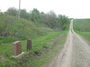
The western terminus of the Sullivan Line is north of Sheridan, Missouri
Sheridan, Missouri
Sheridan is a city in Worth County, Missouri, United States, near the Platte River. The population was 185 at the 2000 census, at which time it was a town.-Geography:Sheridan is located at ....
, at north latitude 40.571079 Rather than drawing a border straight east he was to drift north about 12 miles to 40.613643 at the boundary's eastern terminus just south of what is now Farmington, Iowa
Farmington, Iowa
Farmington is a city in Van Buren County, Iowa, United States. The population was 756 at the 2000 census.-Geography:Farmington is located at , on the east bank of Des Moines River....
.
When Missouri prepared to enter the Union in 1820, various boundaries were discussed before it was finally decided to go with a boundary that had already been formally surveyed and so the Sullivan line was picked.
However the Missouri Constitution muddied the debate when with phrase:
- to the intersection of the parallel of latitude which passes through the rapids of the River Des Moines
As it happened, there were no rapids where Sullivan came to the Des Moines River. However, the Des Moines Rapids
Des Moines Rapids
The Des Moines Rapids between Nauvoo, Illinois and Keokuk, Iowa-Hamilton, Illinois is one of two major rapids on the Mississippi River that limited Steamboat traffic on the river through the early 19th century....
on the Mississippi River
Mississippi River
The Mississippi River is the largest river system in North America. Flowing entirely in the United States, this river rises in western Minnesota and meanders slowly southwards for to the Mississippi River Delta at the Gulf of Mexico. With its many tributaries, the Mississippi's watershed drains...
were just 15 miles in a straight line east of Sullivan’s eastern terminus.
In the Indian Removal Act
Indian Removal Act
The Indian Removal Act was signed into law by President Andrew Jackson on May 28, 1830.The Removal Act was strongly supported in the South, where states were eager to gain access to lands inhabited by the Five Civilized Tribes. In particular, Georgia, the largest state at that time, was involved in...
of 1830, Sullivan’s lines were used for the removal of almost all Native Americans from the eastern portion of the United States (in such events as the Trail of Tears
Trail of Tears
The Trail of Tears is a name given to the forced relocation and movement of Native American nations from southeastern parts of the United States following the Indian Removal Act of 1830...
).
In 1832, at the conclusion of the Black Hawk War
Black Hawk War
The Black Hawk War was a brief conflict fought in 1832 between the United States and Native Americans headed by Black Hawk, a Sauk leader. The war erupted soon after Black Hawk and a group of Sauks, Meskwakis, and Kickapoos known as the "British Band" crossed the Mississippi River into the U.S....
, the Sac and Fox conceded the eastern section of Iowa and the western section of Illinois
Illinois
Illinois is the fifth-most populous state of the United States of America, and is often noted for being a microcosm of the entire country. With Chicago in the northeast, small industrial cities and great agricultural productivity in central and northern Illinois, and natural resources like coal,...
. In the terms the 12 mile stretch between the end of the Sullivan Line and the Mississippi was conceded (in what was called Half Breed Tract because it was to be set aside for mixed race residents).
In 1836, the western boundary of the Sullivan Line latitude was extended 45 miles east to the Missouri River just south of Hamburg, Iowa
Hamburg, Iowa
Hamburg is a city in Fremont County, Iowa, United States, along the Nishnabotna River. The population was 1,240 at the 2000 census.-Geography:According to the United States Census Bureau, the city has a total area of , all of it land.-Demographics:...
when the federal government relocated the already relocated tribes further west in the Platte Purchase
Platte Purchase
The Platte Purchase was a land acquisition in 1836 by the United States government from Native American tribes all of which was east bank lands along the Missouri River that added to the northwest corner of the state of Missouri. The area acquired is almost as large as the states of Delaware and...
. The land was annexed to Missouri.
The western extension did not have the same quirks as the first survey since the solar compass
Solar compass
The solar compass, an astronomical instrument, was first invented and made by William Austin Burt. He patented it on February 25, 1836, in the United States Patent Office as No 9428X. It received a medal at the Great Exhibition of 1851...
had made it easier to make accurate east-west surveys.
However the quirks of the eastern portion of the Sullivan Line were to stir passions as Iowa prepared to enter the Union. Missouri, citing evidence from surveyor Joseph C. Brown
Joseph C. Brown
Joseph C. Brown was a surveyor in the United States who made several major surveys in the Louisiana Territory.Among his notable surveys:...
, who had established the meridian grid for the Louisiana Purchase
Louisiana Purchase
The Louisiana Purchase was the acquisition by the United States of America of of France's claim to the territory of Louisiana in 1803. The U.S...
, said using the Kaw Point starting point was invalid and that the survey should have been based on the mouth of the Ohio River
Ohio River
The Ohio River is the largest tributary, by volume, of the Mississippi River. At the confluence, the Ohio is even bigger than the Mississippi and, thus, is hydrologically the main stream of the whole river system, including the Allegheny River further upstream...
. Using that calculation, he said that Missouri’s border should extend about 9.5 miles even further into Iowa (with the town of Keosauqua, Iowa
Keosauqua, Iowa
Keosauqua is a city in Van Buren County, Iowa, United States. The population was 1,066 at the 2000 census. It is the county seat of Van Buren County.-History:...
, specifically coming into play).
In 1839, the Clark County, Missouri
Clark County, Missouri
Clark County is a county located in the U.S. state of Missouri. As of 2010, the population was 7,139. Its county seat is Kahoka. The county was organized in 1836 and named after William Clark, leader of the Lewis and Clark Expedition and later a Governor of Missouri Territory.Clark County is part...
sheriff went into this new stretch to collect taxes. When the residents of Iowa refused to pay, he is said to have cut down three trees to collect honey bee
Honey bee
Honey bees are a subset of bees in the genus Apis, primarily distinguished by the production and storage of honey and the construction of perennial, colonial nests out of wax. Honey bees are the only extant members of the tribe Apini, all in the genus Apis...
hives in lieu of taxes. He was arrested.
Residents from both sides threatened to fight, before the governors agreed to let the United States Supreme Court settle the matter.
Also, in 1839, Latter Day Saints followers of Joseph Smith, Jr., regrouped at Nauvoo, Illinois
Nauvoo, Illinois
Nauvoo is a small city in Hancock County, Illinois, United States. Although the population was just 1,063 at the 2000 census, and despite being difficult to reach due to its location in a remote corner of Illinois, Nauvoo attracts large numbers of visitors for its historic importance and its...
, on the Mississippi River after having been kicked out of Missouri in the Mormon War. Nauvoo lies in a straight line with the Sullivan Line. In 1844 after Smith was killed, his followers began their trek west that was to ultimately lead them to Utah
Utah
Utah is a state in the Western United States. It was the 45th state to join the Union, on January 4, 1896. Approximately 80% of Utah's 2,763,885 people live along the Wasatch Front, centering on Salt Lake City. This leaves vast expanses of the state nearly uninhabited, making the population the...
. The first Iowa leg of the trail is just north of the Sullivan Line.
In 1849, the Supreme Court ruled that the border, even with its quirks, was valid since it had been written into the Missouri Constitution. However, the border was resurveyed to address individual small anomalies.
Following various disputes, Midland GIS Solutions of Maryville, Missouri
Maryville, Missouri
Maryville is a city in Nodaway County, Missouri, United States. The population was 10,581 at the 2000 census. The town, organized on February 14, 1845, was named for Mrs. Mary Graham, wife of Amos Graham, then the county clerk. Mary was the first Caucasian woman to have lived within the boundaries...
, led by Troy Hayes on a contract with the State of Missouri, resurveyed the border, discovering the markers from the Supreme Court survey of 1850