
.gif)
Subtropical Storm Andrea (2007)
Encyclopedia
Subtropical Storm Andrea was the first named storm and first subtropical cyclone
of the 2007 Atlantic hurricane season
. It developed out of a previously non-tropical low on May 9 about 150 miles (240 km) northeast of Daytona Beach, Florida
, three weeks before the official start of the season. After encountering dry air and increased vertical wind shear
, Andrea weakened to a subtropical depression on May 10 while remaining nearly stationary, and early on May 11 the National Hurricane Center
discontinued advisories. Andrea was the first pre-season storm to develop since Tropical Storm Ana
in April 2003. Additionally, the storm was the first Atlantic named storm in May since Tropical Storm Arlene in 1981.
The storm produced rough surf along the coastline from Florida
to North Carolina
, causing beach erosion
and some damage. In some areas, the waves eroded up to 20 feet (6 m) of beach, leaving 70 homes in imminent danger of collapse. Offshore of North Carolina
, high waves of 34 feet (10 m) and tropical-storm-force winds damaged three boats; their combined nine passengers were rescued by the Coast Guard
, although all nine sustained injuries. Light rainfall was also reported in some coastal locations. Damage was minimal, but six people drowned as a result of the storm.
dropped southward through the western Atlantic Ocean
, forcing a back-door cold front
—a cold front that moves southwestward ahead of a building surface ridge
to its north or northeast—southward. For several days, forecast models
had anticipated for the trough to evolve into a closed low pressure area
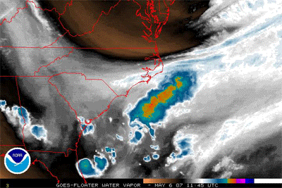
, and on May 6, a frontal low with a large and well-defined circulation developed about 90 miles (140 km) east of Cape Hatteras
. The low maintained scattered convection
around its circulation center, and in conjunction with the strong high pressure to its north a very tight pressure gradient produced gale force winds near the coastline. The extratropical storm tracked southeastward and later turned to the southwest, and steadily deepened; on May 7 it attained hurricane force winds. With a lack of tropical moisture, its corresponding convection was minimal and scattered.
The National Hurricane Center
first mentioned the possibility of tropical cyclogenesis
on May 8 while the storm was located about 230 miles (370 km) east-southeast of the South Carolina
coastline. Its associated convection
had steadily increased as it tracked slowly westward at 5–10 mph (8–16 km/h). The system changed little throughout the day, though by the following morning hurricane specialists indicated the low was acquiring subtropical characteristics
as it tracked over progressively warmer waters. Early on May 9, a Hurricane Hunters
flight into the system revealed winds of 45 mph (70 km/h) and a flat thermal core, which indicated the system was neither warm-core nor cold-core
. In addition, satellite imagery indicated a consolidation of the convection near the center, as well as hints of upper-level outflow
and a contraction of the radius of maximum wind
s from more than 115 miles (185 km) to about 70 miles (120 km). Based on the observations and the hybrid structure of the system, the National Hurricane Center classified the low as Subtropical Storm Andrea at 1500 UTC
on May 9 about 150 miles (240 km) northeast of Daytona Beach, Florida
. During a subsequent analysis of the storm, researchers estimated the storm transitioned into a subtropical cyclone nine hours earlier. As Andrea developed before June 1—the traditional start of hurricane seasons in the Atlantic Ocean—it became the first pre-season storm to develop since Tropical Storm Ana
in April 2003. Additionally, the storm was the first Atlantic named storm in May since Tropical Storm Arlene in 1981.
 Upon first becoming a subtropical cyclone, Andrea was embedded within a large, nearly stationary deep-layer trough
, resulting in a westward movement. Drifting over sea surface temperature
s of no more than 77º F
(25º C
), the organization of the system deteriorated with a significant decrease in convection; by early on May 10 much of the associated weather was located to the east of the cyclone within a band of moderate convection due to a brief spell of westerly vertical wind shear
. Additionally, the center of circulation had become disorganized, with several small cloud swirls within the larger circulation. This disorganization of the center, combined with increasing wind shear and dry air suppressing convective activity, caused it to begin weakening later that morning. By 1500 UTC on May 10, only a few thunderstorms remained near the center, and thus the NHC downgraded Andrea to subtropical depression status. Though a few intermittent thunderstorms persisted over the eastern semicircle, it was disorganized and weak; having been without significant deep convection for 18 hours, the National Hurricane Center discontinued advisories early on May 11 while located about 80 miles (125 km) northeast of Cape Canaveral, Florida
.
Later on May 11, convection again re-fired over the center as it drifted south-southeastward, though it lacked sufficient organization to qualify it as a tropical cyclone. By May 12, shower activity had organized greatly to the east of the center, and the National Hurricane Center remarked that a small increase in convection would result in the formation of a tropical depression. It accelerated east-northeastward away from the continental United States
without redeveloping, and after passing over cooler waters the remnants of Andrea merged with an approaching cold front
on May 14.
offices issued a High Surf Advisory for much of the coastline from Florida through North Carolina. Upon first becoming a subtropical cyclone, the National Hurricane Center issued a tropical storm watch
from the mouth of the Altamaha River
in Georgia
southward to Flagler Beach, Florida
. The watch was discontinued after Andrea weakened to a subtropical depression. Additionally, a gale warning was issued for much of the South Carolina
coastline.
At Isle of Palms
in South Carolina, workers and dozens of firefighters prepared sandbags in preparation for high tide after waves from the storm previously caused moderate beach erosion. As a precaution, officials there intentionally cut power and gas to multiple uninhabited buildings. Officials closed schools in Dare County, North Carolina
due to the threat for high winds from the storm. The North Carolina Department of Transportation
also canceled ferry transportation to and from Ocracoke
and Knotts Island, North Carolina
.
 Prior to becoming a subtropical cyclone
, the low produced gale-force winds and dangerous surf near the coast from North Carolina through Georgia, and later along the coast of Florida. Significant swells were also reported in the Bahamas. The waves caused beach erosion and washed up against coastal houses along the southeast coast of the United States.
. All nine were injured to some degree; three endured hypothermia, one received a broken rib, and one Coast Guardsman experienced back injuries from the surf. Another boat and its four occupants were reported missing, and after twelve days they remain missing. Rough waves from the precursor low left two kayakers missing near Seabrook Island, South Carolina
. One was found the next day, and the other was found dead a week later.
Onshore, winds reached 52 mph (84 km/h) in Norfolk, Virginia
, with an unofficial report of 57 mph (92 km/h) near Virginia Beach
. Similar observations occurred along the Outer Banks
, with the winds knocking some tree limbs onto power lines; some isolated power outages were reported. Wind damage included some roofs losing shingles from the winds. In Elizabeth City, North Carolina
, an outer rainband dropped 0.5 inches (10 mm) of precipitation in about two hours as well as several lightning strikes; one bolt of lightning injured two firefighters. The winds covered portions of North Carolina Highway 12 with sand, and for a day the route was closed after waves from the storm washed out about 200 feet (60 m) of roadway. In some locations, the waves eroded up to 20 feet (6 m) of beach, leaving 70 homes in imminent danger. On St. Simons Island
in Georgia, the storm produced a storm tide
of 8.09 feet (2.43 m). Trace amounts of rainfall occurred in the southeastern portion of the state.
; the two occupants were rescued without injury. Additionally, the waves displaced a sailboat that had previously been washed ashore in Juno Beach
. Large waves flooded a parking lot and destroyed several fences and tree branches at Jupiter Beach
, which resulted in its temporary closure; nearby a maintenance shed was destroyed. Eight Leatherback Sea Turtle
nests in Boca Raton
were destroyed after the surf reached the dunes. Due to high surf, the beach pier at Flagler Beach
was closed for about a day. Minor to moderate beach erosion caused the Florida Department of Transportation to fill in areas near the seawall with sand. One death occurred when a surfer drowned in the rough waves off the coast at New Smyrna Beach
in Volusia County
. Outer rainbands produced light rainfall, with the highest report in the Jacksonville
National Weather Service area of responsibility totaling 0.77 inches (20 mm); the bands also cause tropical storm force wind gusts in the northeastern portion of the state. The winds spread smoke from local brush fires
through the Tampa Bay
area to Miami
. High winds from Andrea were reported as fueling severe wildfires
in northern Florida and southern Georgia.
Other Atlantic subtropical cyclones
Subtropical cyclone
A subtropical cyclone is a weather system that has some characteristics of a tropical and an extratropical cyclone. As early as the 1950s, meteorologists were unclear whether they should be characterized as tropical or extratropical cyclones. They were officially recognized by the National...
of the 2007 Atlantic hurricane season
2007 Atlantic hurricane season
The 2007 Atlantic hurricane season was an active Atlantic hurricane season that produced 17 tropical cyclones, 15 tropical storms, six hurricanes, and two major hurricanes. It officially started on June 1 and ended on November 30, dates which conventionally delimit the...
. It developed out of a previously non-tropical low on May 9 about 150 miles (240 km) northeast of Daytona Beach, Florida
Daytona Beach, Florida
Daytona Beach is a city in Volusia County, Florida, USA. According to 2008 U.S. Census Bureau estimates, the city has a population of 64,211. Daytona Beach is a principal city of the Deltona – Daytona Beach – Ormond Beach, Florida Metropolitan Statistical Area, which the census bureau estimated had...
, three weeks before the official start of the season. After encountering dry air and increased vertical wind shear
Wind shear
Wind shear, sometimes referred to as windshear or wind gradient, is a difference in wind speed and direction over a relatively short distance in the atmosphere...
, Andrea weakened to a subtropical depression on May 10 while remaining nearly stationary, and early on May 11 the National Hurricane Center
National Hurricane Center
The National Hurricane Center , located at Florida International University in Miami, Florida, is the division of the National Weather Service responsible for tracking and predicting weather systems within the tropics between the Prime Meridian and the 140th meridian west poleward to the 30th...
discontinued advisories. Andrea was the first pre-season storm to develop since Tropical Storm Ana
Tropical Storm Ana (2003)
Tropical Storm Ana was the only tropical cyclone on record in the Atlantic basin to form during the month of April. The first tropical cyclone of the season, it developed as a subtropical cyclone from a non-tropical low on April 20 to the west of Bermuda...
in April 2003. Additionally, the storm was the first Atlantic named storm in May since Tropical Storm Arlene in 1981.
The storm produced rough surf along the coastline from Florida
Florida
Florida is a state in the southeastern United States, located on the nation's Atlantic and Gulf coasts. It is bordered to the west by the Gulf of Mexico, to the north by Alabama and Georgia and to the east by the Atlantic Ocean. With a population of 18,801,310 as measured by the 2010 census, it...
to North Carolina
North Carolina
North Carolina is a state located in the southeastern United States. The state borders South Carolina and Georgia to the south, Tennessee to the west and Virginia to the north. North Carolina contains 100 counties. Its capital is Raleigh, and its largest city is Charlotte...
, causing beach erosion
Coastal erosion
Coastal erosion is the wearing away of land and the removal of beach or dune sediments by wave action, tidal currents, wave currents, or drainage...
and some damage. In some areas, the waves eroded up to 20 feet (6 m) of beach, leaving 70 homes in imminent danger of collapse. Offshore of North Carolina
North Carolina
North Carolina is a state located in the southeastern United States. The state borders South Carolina and Georgia to the south, Tennessee to the west and Virginia to the north. North Carolina contains 100 counties. Its capital is Raleigh, and its largest city is Charlotte...
, high waves of 34 feet (10 m) and tropical-storm-force winds damaged three boats; their combined nine passengers were rescued by the Coast Guard
United States Coast Guard
The United States Coast Guard is a branch of the United States Armed Forces and one of the seven U.S. uniformed services. The Coast Guard is a maritime, military, multi-mission service unique among the military branches for having a maritime law enforcement mission and a federal regulatory agency...
, although all nine sustained injuries. Light rainfall was also reported in some coastal locations. Damage was minimal, but six people drowned as a result of the storm.
Meteorological history
In early May, an upper-level troughTrough (meteorology)
A trough is an elongated region of relatively low atmospheric pressure, often associated with fronts.Unlike fronts, there is not a universal symbol for a trough on a weather chart. The weather charts in some countries or regions mark troughs by a line. In the United States, a trough may be marked...
dropped southward through the western Atlantic Ocean
Atlantic Ocean
The Atlantic Ocean is the second-largest of the world's oceanic divisions. With a total area of about , it covers approximately 20% of the Earth's surface and about 26% of its water surface area...
, forcing a back-door cold front
Cold front
A cold front is defined as the leading edge of a cooler mass of air, replacing a warmer mass of air.-Development of cold front:The cooler and denser air wedges under the less-dense warmer air, lifting it...
—a cold front that moves southwestward ahead of a building surface ridge
Ridge (meteorology)
A ridge is an elongated region of relatively high atmospheric pressure, the opposite of a trough....
to its north or northeast—southward. For several days, forecast models
Tropical cyclone prediction model
A tropical cyclone forecast model is a computer program that uses meteorological data to forecast aspects of the future state of tropical cyclones. There are three types of models: statistical, dynamical, or combined statistical-dynamic...
had anticipated for the trough to evolve into a closed low pressure area
Low pressure area
A low-pressure area, or "low", is a region where the atmospheric pressure at sea level is below that of surrounding locations. Low-pressure systems form under areas of wind divergence which occur in upper levels of the troposphere. The formation process of a low-pressure area is known as...
, and on May 6, a frontal low with a large and well-defined circulation developed about 90 miles (140 km) east of Cape Hatteras
Cape Hatteras
Cape Hatteras is a cape on the coast of North Carolina. It is the point that protrudes the farthest to the southeast along the northeast-to-southwest line of the Atlantic coast of North America...
. The low maintained scattered convection
Atmospheric convection
Atmospheric convection is the result of a parcel-environment instability, or temperature difference, layer in the atmosphere. Different lapse rates within dry and moist air lead to instability. Mixing of air during the day which expands the height of the planetary boundary layer leads to...
around its circulation center, and in conjunction with the strong high pressure to its north a very tight pressure gradient produced gale force winds near the coastline. The extratropical storm tracked southeastward and later turned to the southwest, and steadily deepened; on May 7 it attained hurricane force winds. With a lack of tropical moisture, its corresponding convection was minimal and scattered.
The National Hurricane Center
National Hurricane Center
The National Hurricane Center , located at Florida International University in Miami, Florida, is the division of the National Weather Service responsible for tracking and predicting weather systems within the tropics between the Prime Meridian and the 140th meridian west poleward to the 30th...
first mentioned the possibility of tropical cyclogenesis
Tropical cyclogenesis
Tropical cyclogenesis is the term that describes the development and strengthening of a tropical cyclone in the atmosphere. The mechanisms through which tropical cyclogenesis occurs are distinctly different from those through which mid-latitude cyclogenesis occurs...
on May 8 while the storm was located about 230 miles (370 km) east-southeast of the South Carolina
South Carolina
South Carolina is a state in the Deep South of the United States that borders Georgia to the south, North Carolina to the north, and the Atlantic Ocean to the east. Originally part of the Province of Carolina, the Province of South Carolina was one of the 13 colonies that declared independence...
coastline. Its associated convection
Convection
Convection is the movement of molecules within fluids and rheids. It cannot take place in solids, since neither bulk current flows nor significant diffusion can take place in solids....
had steadily increased as it tracked slowly westward at 5–10 mph (8–16 km/h). The system changed little throughout the day, though by the following morning hurricane specialists indicated the low was acquiring subtropical characteristics
Subtropical cyclone
A subtropical cyclone is a weather system that has some characteristics of a tropical and an extratropical cyclone. As early as the 1950s, meteorologists were unclear whether they should be characterized as tropical or extratropical cyclones. They were officially recognized by the National...
as it tracked over progressively warmer waters. Early on May 9, a Hurricane Hunters
Hurricane Hunters
The Hurricane Hunters are aircraft that fly into tropical cyclones in the North Atlantic Ocean and Northeastern Pacific Ocean for the specific purpose of directly measuring weather data in and around those storms. In the United States, the Air Force, Navy, and NOAA units have all participated in...
flight into the system revealed winds of 45 mph (70 km/h) and a flat thermal core, which indicated the system was neither warm-core nor cold-core
Cold-core low
A cold-core low, also known as a cold low or cold-core cyclone, is a cyclone aloft which has an associated cold pool of air residing at high altitude within the Earth's troposphere. It is a low pressure system which strengthens with height in accordance with the thermal wind relationship. These...
. In addition, satellite imagery indicated a consolidation of the convection near the center, as well as hints of upper-level outflow
Outflow (meteorology)
Outflow, in meteorology, is air that flows outwards from a storm system. It is associated with ridging, or anticyclonic flow. In the low levels of the troposphere, outflow radiates from thunderstorms in the form of a wedge of rain-cooled air, which is visible as a thin rope-like cloud on weather...
and a contraction of the radius of maximum wind
Radius of maximum wind
The radius of maximum wind is the distance between the center of a cyclone and its band of strongest winds. It is a parameter in atmospheric dynamics and tropical cyclone forecasting. The highest rainfall rates occur near the RMW of tropical cyclones. The extent of a cyclone's storm surge and...
s from more than 115 miles (185 km) to about 70 miles (120 km). Based on the observations and the hybrid structure of the system, the National Hurricane Center classified the low as Subtropical Storm Andrea at 1500 UTC
Coordinated Universal Time
Coordinated Universal Time is the primary time standard by which the world regulates clocks and time. It is one of several closely related successors to Greenwich Mean Time. Computer servers, online services and other entities that rely on having a universally accepted time use UTC for that purpose...
on May 9 about 150 miles (240 km) northeast of Daytona Beach, Florida
Daytona Beach, Florida
Daytona Beach is a city in Volusia County, Florida, USA. According to 2008 U.S. Census Bureau estimates, the city has a population of 64,211. Daytona Beach is a principal city of the Deltona – Daytona Beach – Ormond Beach, Florida Metropolitan Statistical Area, which the census bureau estimated had...
. During a subsequent analysis of the storm, researchers estimated the storm transitioned into a subtropical cyclone nine hours earlier. As Andrea developed before June 1—the traditional start of hurricane seasons in the Atlantic Ocean—it became the first pre-season storm to develop since Tropical Storm Ana
Tropical Storm Ana (2003)
Tropical Storm Ana was the only tropical cyclone on record in the Atlantic basin to form during the month of April. The first tropical cyclone of the season, it developed as a subtropical cyclone from a non-tropical low on April 20 to the west of Bermuda...
in April 2003. Additionally, the storm was the first Atlantic named storm in May since Tropical Storm Arlene in 1981.
Trough (meteorology)
A trough is an elongated region of relatively low atmospheric pressure, often associated with fronts.Unlike fronts, there is not a universal symbol for a trough on a weather chart. The weather charts in some countries or regions mark troughs by a line. In the United States, a trough may be marked...
, resulting in a westward movement. Drifting over sea surface temperature
Sea surface temperature
Sea surface temperature is the water temperature close to the oceans surface. The exact meaning of surface varies according to the measurement method used, but it is between and below the sea surface. Air masses in the Earth's atmosphere are highly modified by sea surface temperatures within a...
s of no more than 77º F
Fahrenheit
Fahrenheit is the temperature scale proposed in 1724 by, and named after, the German physicist Daniel Gabriel Fahrenheit . Within this scale, the freezing of water into ice is defined at 32 degrees, while the boiling point of water is defined to be 212 degrees...
(25º C
Celsius
Celsius is a scale and unit of measurement for temperature. It is named after the Swedish astronomer Anders Celsius , who developed a similar temperature scale two years before his death...
), the organization of the system deteriorated with a significant decrease in convection; by early on May 10 much of the associated weather was located to the east of the cyclone within a band of moderate convection due to a brief spell of westerly vertical wind shear
Wind shear
Wind shear, sometimes referred to as windshear or wind gradient, is a difference in wind speed and direction over a relatively short distance in the atmosphere...
. Additionally, the center of circulation had become disorganized, with several small cloud swirls within the larger circulation. This disorganization of the center, combined with increasing wind shear and dry air suppressing convective activity, caused it to begin weakening later that morning. By 1500 UTC on May 10, only a few thunderstorms remained near the center, and thus the NHC downgraded Andrea to subtropical depression status. Though a few intermittent thunderstorms persisted over the eastern semicircle, it was disorganized and weak; having been without significant deep convection for 18 hours, the National Hurricane Center discontinued advisories early on May 11 while located about 80 miles (125 km) northeast of Cape Canaveral, Florida
Cape Canaveral, Florida
Cape Canaveral is a city in Brevard County, Florida, United States. The population was 8,829 at the 2000 census. As of 2008, the estimated population according to the U.S. Census Bureau was 10,147...
.
Later on May 11, convection again re-fired over the center as it drifted south-southeastward, though it lacked sufficient organization to qualify it as a tropical cyclone. By May 12, shower activity had organized greatly to the east of the center, and the National Hurricane Center remarked that a small increase in convection would result in the formation of a tropical depression. It accelerated east-northeastward away from the continental United States
United States
The United States of America is a federal constitutional republic comprising fifty states and a federal district...
without redeveloping, and after passing over cooler waters the remnants of Andrea merged with an approaching cold front
Cold front
A cold front is defined as the leading edge of a cooler mass of air, replacing a warmer mass of air.-Development of cold front:The cooler and denser air wedges under the less-dense warmer air, lifting it...
on May 14.
Preparations
Due to rough surf from the precursor low, local National Weather ServiceNational Weather Service
The National Weather Service , once known as the Weather Bureau, is one of the six scientific agencies that make up the National Oceanic and Atmospheric Administration of the United States government...
offices issued a High Surf Advisory for much of the coastline from Florida through North Carolina. Upon first becoming a subtropical cyclone, the National Hurricane Center issued a tropical storm watch
Tropical cyclone warnings and watches
Warnings and watches are two levels of alert issued by national weather forecasting bodies to coastal areas threatened by the imminent approach of a tropical cyclone of tropical storm or hurricane intensity. They are notices to the local population and civil authorities to make appropriate...
from the mouth of the Altamaha River
Altamaha River
The Altamaha River is a major river of the American state of Georgia. It flows generally eastward for 137 miles from its origin at the confluence of the Oconee River and Ocmulgee River towards the Atlantic Ocean, where it empties into the ocean near Brunswick, Georgia. There are no dams...
in Georgia
Georgia (U.S. state)
Georgia is a state located in the southeastern United States. It was established in 1732, the last of the original Thirteen Colonies. The state is named after King George II of Great Britain. Georgia was the fourth state to ratify the United States Constitution, on January 2, 1788...
southward to Flagler Beach, Florida
Flagler Beach, Florida
Flagler Beach is a city in Flagler and Volusia counties in the U.S. state of Florida. The population was 4,954 at the 2000 census, with an estimated population of 5,228 in 2004.Flagler Beach is part of the Palm Coast Metropolitan Statistical Area...
. The watch was discontinued after Andrea weakened to a subtropical depression. Additionally, a gale warning was issued for much of the South Carolina
South Carolina
South Carolina is a state in the Deep South of the United States that borders Georgia to the south, North Carolina to the north, and the Atlantic Ocean to the east. Originally part of the Province of Carolina, the Province of South Carolina was one of the 13 colonies that declared independence...
coastline.
At Isle of Palms
Isle of Palms, South Carolina
Isle of Palms is a city in Charleston County, South Carolina, United States. As of the 2010 census, the population on the island was 4,133. Isle of Palms is a barrier island on the South Carolina coast. As defined by the U.S. Office of Management and Budget, and used by the U.S...
in South Carolina, workers and dozens of firefighters prepared sandbags in preparation for high tide after waves from the storm previously caused moderate beach erosion. As a precaution, officials there intentionally cut power and gas to multiple uninhabited buildings. Officials closed schools in Dare County, North Carolina
Dare County, North Carolina
-National protected areas:* Alligator River National Wildlife Refuge * Cape Hatteras National Seashore * Fort Raleigh National Historic Site* Pea Island National Wildlife Refuge* Wright Brothers National Memorial-Demographics:...
due to the threat for high winds from the storm. The North Carolina Department of Transportation
North Carolina Department of Transportation
The North Carolina Department of Transportation is responsible for building, repairing, and operating highways, bridges, and other modes of transportation, including ferries in the U.S. state of North Carolina.-History:...
also canceled ferry transportation to and from Ocracoke
Ocracoke, North Carolina
Ocracoke is a census-designated place and unincorporated town located at the southern end of Ocracoke Island, located entirely within Hyde County, North Carolina. The population was 769 as of the 2000 census...
and Knotts Island, North Carolina
Knotts Island, North Carolina
Knotts Island is a small unincorporated community in Currituck County, North Carolina. The community is located on a marshy island, bordered by the Currituck Sound, North Landing River, Back Bay, and Knotts Island Bay. Knotts Island is home to Mackay Island National Wildlife Refuge. Knotts Island...
.
Impact
Subtropical cyclone
A subtropical cyclone is a weather system that has some characteristics of a tropical and an extratropical cyclone. As early as the 1950s, meteorologists were unclear whether they should be characterized as tropical or extratropical cyclones. They were officially recognized by the National...
, the low produced gale-force winds and dangerous surf near the coast from North Carolina through Georgia, and later along the coast of Florida. Significant swells were also reported in the Bahamas. The waves caused beach erosion and washed up against coastal houses along the southeast coast of the United States.
Southeast U.S.
Off the coast of North Carolina, the storm produced 34-foot (10-m) waves and storm force winds which damaged three boats; their combined nine passengers were rescued by the Coast GuardUnited States Coast Guard
The United States Coast Guard is a branch of the United States Armed Forces and one of the seven U.S. uniformed services. The Coast Guard is a maritime, military, multi-mission service unique among the military branches for having a maritime law enforcement mission and a federal regulatory agency...
. All nine were injured to some degree; three endured hypothermia, one received a broken rib, and one Coast Guardsman experienced back injuries from the surf. Another boat and its four occupants were reported missing, and after twelve days they remain missing. Rough waves from the precursor low left two kayakers missing near Seabrook Island, South Carolina
Seabrook Island, South Carolina
Seabrook Island is a town in Charleston County, South Carolina, United States. The population was 1,250 at the 2000 census.As defined by the U.S. Office of Management and Budget, and used by the U.S...
. One was found the next day, and the other was found dead a week later.
Onshore, winds reached 52 mph (84 km/h) in Norfolk, Virginia
Norfolk, Virginia
Norfolk is an independent city in the Commonwealth of Virginia in the United States. With a population of 242,803 as of the 2010 Census, it is Virginia's second-largest city behind neighboring Virginia Beach....
, with an unofficial report of 57 mph (92 km/h) near Virginia Beach
Virginia Beach, Virginia
Virginia Beach is an independent city located in the Hampton Roads metropolitan area of Virginia, on the Atlantic Ocean at the mouth of the Chesapeake Bay...
. Similar observations occurred along the Outer Banks
Outer Banks
The Outer Banks is a 200-mile long string of narrow barrier islands off the coast of North Carolina, beginning in the southeastern corner of Virginia Beach on the east coast of the United States....
, with the winds knocking some tree limbs onto power lines; some isolated power outages were reported. Wind damage included some roofs losing shingles from the winds. In Elizabeth City, North Carolina
Elizabeth City, North Carolina
Elizabeth City is a city in Pasquotank County and Camden County in the State of North Carolina. With a population of 18,683 at the 2010 census, Elizabeth City is the county seat of Pasquotank County....
, an outer rainband dropped 0.5 inches (10 mm) of precipitation in about two hours as well as several lightning strikes; one bolt of lightning injured two firefighters. The winds covered portions of North Carolina Highway 12 with sand, and for a day the route was closed after waves from the storm washed out about 200 feet (60 m) of roadway. In some locations, the waves eroded up to 20 feet (6 m) of beach, leaving 70 homes in imminent danger. On St. Simons Island
St. Simons, Georgia
St. Simons is a census-designated place located on St. Simons Island in Glynn County, Georgia, United States. Both the community and the island are commonly considered to be one location, known simply as "St. Simons Island", or locally as "The Island". St...
in Georgia, the storm produced a storm tide
Storm tide
A storm tide is a tide with a high flood period caused by a storm. Storm tides can be a severe danger to the coast and the people living along the coast. The water level can rise to more than 5 meters above the normal tide....
of 8.09 feet (2.43 m). Trace amounts of rainfall occurred in the southeastern portion of the state.
Florida
In Florida, waves of over 10 feet (3 m) in height capsized a boat near LantanaLantana, Florida
Lantana is a town in Palm Beach County, Florida, United States. The population was 9,437 at the 2000 census. As of 2004, the population recorded by the U.S. Census Bureau is 10,389.-History:...
; the two occupants were rescued without injury. Additionally, the waves displaced a sailboat that had previously been washed ashore in Juno Beach
Juno Beach, Florida
Juno Beach is a town in Palm Beach County, Florida, United States. The population was 3,262 at the 2000 census. As of 2004, the population recorded by the U.S. Census Bureau is 3,391. Juno Beach is home to the headquarters of Florida Power & Light...
. Large waves flooded a parking lot and destroyed several fences and tree branches at Jupiter Beach
Jupiter, Florida
Jupiter is a town located in Palm Beach County, Florida. As of the 2000 census, the town had a total population of 39,328. The estimate population for 2009 is 50,606. As of 2006, the population had grown to 50,028, according to the University of Florida, Bureau of Economic and Business Research....
, which resulted in its temporary closure; nearby a maintenance shed was destroyed. Eight Leatherback Sea Turtle
Leatherback Sea Turtle
The leatherback sea turtle is the largest of all living sea turtles and the fourth largest modern reptile behind three crocodilians. It is the only living species in the genus Dermochelys. It can easily be differentiated from other modern sea turtles by its lack of a bony shell. Instead, its...
nests in Boca Raton
Boca Raton, Florida
Boca Raton is a city in Palm Beach County, Florida, USA, incorporated in May 1925. In the 2000 census, the city had a total population of 74,764; the 2006 population recorded by the U.S. Census Bureau was 86,396. However, the majority of the people under the postal address of Boca Raton, about...
were destroyed after the surf reached the dunes. Due to high surf, the beach pier at Flagler Beach
Flagler Beach, Florida
Flagler Beach is a city in Flagler and Volusia counties in the U.S. state of Florida. The population was 4,954 at the 2000 census, with an estimated population of 5,228 in 2004.Flagler Beach is part of the Palm Coast Metropolitan Statistical Area...
was closed for about a day. Minor to moderate beach erosion caused the Florida Department of Transportation to fill in areas near the seawall with sand. One death occurred when a surfer drowned in the rough waves off the coast at New Smyrna Beach
New Smyrna Beach, Florida
New Smyrna Beach is a city in Volusia County, Florida, United States. The population was 20,048 according to the 2000 census. As of 2007, the population recorded by the U.S. Census Bureau is 23,161.-History:...
in Volusia County
Volusia County, Florida
Volusia County is a county located in the state of Florida. The U.S. Census Bureau 2010 official county's population was 494,593 . Its county seat is DeLand, and its most populous city is currently Deltona....
. Outer rainbands produced light rainfall, with the highest report in the Jacksonville
Jacksonville, Florida
Jacksonville is the largest city in the U.S. state of Florida in terms of both population and land area, and the largest city by area in the contiguous United States. It is the county seat of Duval County, with which the city government consolidated in 1968...
National Weather Service area of responsibility totaling 0.77 inches (20 mm); the bands also cause tropical storm force wind gusts in the northeastern portion of the state. The winds spread smoke from local brush fires
Wildfire
A wildfire is any uncontrolled fire in combustible vegetation that occurs in the countryside or a wilderness area. Other names such as brush fire, bushfire, forest fire, desert fire, grass fire, hill fire, squirrel fire, vegetation fire, veldfire, and wilkjjofire may be used to describe the same...
through the Tampa Bay
Tampa Bay
Tampa Bay is a large natural harbor and estuary along the Gulf of Mexico on the west central coast of Florida, comprising Hillsborough Bay, Old Tampa Bay, Middle Tampa Bay, and Lower Tampa Bay."Tampa Bay" is not the name of any municipality...
area to Miami
Miami, Florida
Miami is a city located on the Atlantic coast in southeastern Florida and the county seat of Miami-Dade County, the most populous county in Florida and the eighth-most populous county in the United States with a population of 2,500,625...
. High winds from Andrea were reported as fueling severe wildfires
Bugaboo scrub fire
The Bugaboo Scrub Fire was a wildfire that raged from April to June 2007 and ultimately become the largest fire in the history of both Georgia and Florida. The Bugaboo, which was not actually named until it had blazed for nearly a month, started in the Okefenokee Swamp, most of which is located in...
in northern Florida and southern Georgia.
See also
- List of Florida hurricanes
- List of North Carolina hurricanes
- List of storms in the 2007 Atlantic hurricane season
Other Atlantic subtropical cyclones
- Timeline of the 2007 Atlantic hurricane seasonTimeline of the 2007 Atlantic hurricane seasonThis timeline documents all the storm formations, strengthening, weakening, landfalls, extratropical transitions, as well as dissipation during the 2007 Atlantic hurricane season. The season officially began on June 1, 2007, and ended on November 30, although Subtropical Storm Andrea and Tropical...