

South Downs National Park
Encyclopedia
The South Downs National Park is England
's newest National Park
, having become fully operational on 1 April 2011. The park, covering an area of 1627 sqkm in southern England
, stretches for 140 kilometres (87 mi) from Winchester in the west to Eastbourne in the east through the counties of Hampshire
, West Sussex
and East Sussex
. The national park covers not only the chalk ridge of the South Downs
, with its celebrated chalk downland landscape that culminates in the iconic chalky white cliffs of Beachy Head
, but also a substantial part of a separate physiographic region, the western Weald
, with its heavily wooded sandstone and clay hills and vales. The South Downs Way
spans the entire length of the park and is the only National Trail that lies wholly within a national park.
was a notorious example of this). In 1929, the Council for the Preservation of Rural England, led by campaigners including the geographer Vaughan Cornish, submitted a memorandum to the Prime Minister urging the case for national parks, including a national park on part of the South Downs. However, when, towards the end of World War II
, John Dower was asked to report on how a system of national parks in England and Wales might be established, his 1945 report, National Parks in England and Wales, did not identify the South Downs for national park status, but rather included it in a list of "other amenity areas". Sir Arthur Hobhouse
's 1947 Report of the National Parks Committee took a different view, and he included the South Downs in his list of twelve areas recommended for designation as a national park, defined by John Dower as an "extensive area of beautiful and relatively wild country in which, for the nation's benefit...the characteristic landscape beauty is strictly preserved".
The South Downs was the last of the original twelve recommended national parks to be designated. Indeed, the extensive damage that had been caused to the chalk downland
from 1940 onwards through being ploughed up for arable farming and the concomitant disappearance of sheep grazing militated against further consideration of their designation: when the National Parks Commission came to consider the case for designating the South Downs as a national park it concluded, in 1956, that designation was no longer appropriate, noting that the recreational value of the South Downs as a potential national park had been considerably reduced by the extensive cultivation of the downland. But it recognised the "great natural beauty" of the area and proposed to take forward discussions to designate it as an Area of Outstanding Natural Beauty. In due course two AONBs, split along the county boundary, were designated, namely the East Hampshire AONB
in 1962 and the Sussex Downs AONB
in 1966, and these were later to form the basis of the South Downs National Park.
In September 1999 the government, following a review of national parks policy, declared its support for the creation of a South Downs National Park, and announced a consultation on its creation. In January 2003 the then Countryside Agency
(now Natural England
) made an Order to designate the proposed park in 2003 which was submitted to the Secretary of State for the Environment on 27 January 2003.
As a result of objections and representations received on the proposed Order, a public inquiry
was conducted between 10 November 2003 and 23 March 2005, with the aim of recommending to ministers whether a national park should be confirmed and, if so, where its boundaries should be. The results of the inquiry were expected by the end of 2005, but were delayed pending a legal issue arising from a High Court
case challenging part of the Order designating the New Forest National Park.
Following an appeal on the High Court case and new legislation included in the Natural Environment and Rural Communities Act 2006, the South Downs Inquiry report was published on 31 March 2006. It recommended a 23% reduction in the size of the originally-proposed national park, focussing it more narrowly on the chalk downland and excluding from it a large part of the existing East Hampshire and Sussex Downs AONBs. This proved highly controversial, leading to calls from the Campaign for the Protection of Rural England and others for the inclusion of the so-called western Weald
, a region within the two AONBs possessing a geology, ecology and landscape quite different from the chalk hills of the South Downs, within the park boundary to ensure that it remained protected from development. The Secretary of State invited objections and representations on new issues relating to the proposed national park in a consultation that ran from 2 July to 13 August 2007. In the light of the responses received, the Secretary of State decided that it was appropriate to re-open the 2003-05 public inquiry. The inquiry re-opened on 12 February 2008 and was closed on 4 July 2008 after 27 sitting days. The Inspector's report was submitted on 28 November 2008.
On 31 March 2009 the result of the inquiry was published. The Secretary of State
, Hilary Benn
, announced that the South Downs would be designated a national park, and on 12 November 2009 he signed the order confirming the designation. Importantly, he confirmed that a number of hotly disputed areas, including the western Weald, the town of Lewes
and the village of Ditchling
, would be included within the national park.
The new national park came into full operation on 1 April 2011 when the new South Downs National Park Authority assumed statutory responsibility for it. The occasion was marked by an opening ceremony which took place in the market square of Petersfield
, a town situated in the western Weald just 4 kilometres (2.5 mi) north of the chalk escarpment of the South Downs.
; these are:
It must also fulfill the following duty:
The SDNPA is a public body, funded by central government, and run by a board of twenty seven members. The board consists of seven national members, appointed by the environment secretary by means of an open recruitment process; fourteen local authority nominees drawn from the fifteen local authorities covering the park area with Adur and Worthing opting to share a place; and six parish council representatives, two for each county.
The chair of SDNPA is Margaret Paren, a former civil servant who after retirement became involved in campaigning for the national park.
near Winchester in Hampshire
in the west to Beachy Head
, near Eastbourne
in East Sussex
in the east. In its western half, the southern boundary of the park lies up to 10 kilometres (6.2 mi) inland from the south coast; it thus excludes the major coastal towns and cities of Southampton
, Portsmouth
, Chichester
, Bognor Regis
and Littlehampton
. Further east, where the park's southern boundary lies much closer to the coast, it has been carefully drawn to exclude the urban areas of Worthing
, Brighton and Hove, Newhaven
, Seaford
and Eastbourne
, which had all made substantial encroachments onto the Downs during the 19th and 20th centuries. By contrast, the park includes a number of towns situated in the western Weald
, including Petersfield
, Liss
, Midhurst
and Petworth
, and the two historic Sussex towns of Arundel
and Lewes
.
The total population living within the national park is approximately 108,000. Of these 42,000 live in Hampshire, 40,000 in West Sussex and 25,000 in East Sussex. East Hampshire District Council area and Chichester District each have around 30,000 residents in the area and Lewes District 22,000. Winchester has 11,500 residents in the park, with much smaller numbers for the other districts and boroughs. The area receives about 39 million visits each year, which is thought likely to increase as a result of the creation of the national park.
The national park has an area of 1625 sqkm, of which 544 sqkm is in Hampshire, 807 sqkm in West Sussex and 237 sqkm in East Sussex. Among the district council areas, Chichester District has the largest area at 544 sqkm, followed by East Hampshire District with 279 sqkm, Winchester with 265 sqkm, Lewes District with 159 sqkm and Arun 102 sqkm. 93 sqkm are in Horsham District and 60 sqkm in Wealden District.
Apart from a number of boundary revisions, the park incorporates two areas previously designated as Areas of Outstanding Natural Beauty
, the East Hampshire AONB
and Sussex Downs AONB
.
The South Downs National Park's chalk downland is a feature that sets it apart from other national parks in Britain. However, almost a quarter (23%) of the national park consists of a quite different and strongly contrasting physiographic region, the western Weald
, whose densely wooded hills and vales are based on an older Wealden geology of resistant sandstones and softer clays. The highest point in the national park, Blackdown, at 280 metres (918.6 ft) above sea level, is in fact situated in the Weald, on the Greensand Ridge
, whereas the highest point on the chalk escarpment of the South Downs, Butser Hill
, has an elevation of 271 metres (889 ft) above sea level.
 Most of the national park consists of chalk
downland
, although a significant part includes the sandstones and clays of the western Weald
, a strongly contrasting and distinctive landscape of densely-wooded hills and vales.
The chalk was formed in the Late Cretaceous
epoch
, between 100 million and 65 million years ago, when the area was under the sea. During the Cenozoic
era the chalk was uplifted as part of the Weald uplift which created the great Weald-Artois Anticline
, caused by the same orogenic
movements that created the Alps. The relatively resistant chalk rock has, through weathering
, resulted in a classic cuesta
landform, with a northward-facing chalk escarpment
that rises dramatically above the low-lying vales of the Low Weald.
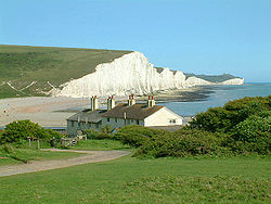
The chalk escarpment reaches the English Channel
west of Eastbourne
, where it forms the dramatic white cliffs of Beachy Head
, the Seven Sisters
and Seaford Head. These cliffs were formed after the end of the last Ice Age
, when sea levels rose and the English Channel was formed, resulting in under-cutting of the chalk by the sea.
The South Downs run linearly west-north-westwards from the Eastbourne area through southern Sussex to the Hampshire downs, separating the south coastal plain from the clays and sandstones of the Weald
. Behind the escarpment, on the dip slope, are the characteristic high, smooth, rolling downland hills interrupted by dry valleys and wind gaps, and the major river gaps of the Cuckmere, Ouse
, Adur
and Arun
.
The chalk is a white sedimentary rock, notably homogeneous and fine-grained, and very permeable. It consists of minute calcite
plates (coccoliths) shed from micro-organisms called coccolithophores. The strata
include numerous layers of flint
nodules
, which have been widely exploited as a material for manufacture of stone tool
s as well as a building material
for dwellings. Similar areas in Britain
include the North Downs
and the Chilterns.
In its western section, the national park extends north beyond the chalk escarpment of the South Downs into a quite different and strongly contrasting physiographic region, the western Weald
, taking in the valley of the western River Rother
, incised into Lower Greensand bedrock, and the densely wooded hills and valleys of the Greensand Ridge
and Weald Clay
south of Haslemere
.
England
England is a country that is part of the United Kingdom. It shares land borders with Scotland to the north and Wales to the west; the Irish Sea is to the north west, the Celtic Sea to the south west, with the North Sea to the east and the English Channel to the south separating it from continental...
's newest National Park
National park
A national park is a reserve of natural, semi-natural, or developed land that a sovereign state declares or owns. Although individual nations designate their own national parks differently A national park is a reserve of natural, semi-natural, or developed land that a sovereign state declares or...
, having become fully operational on 1 April 2011. The park, covering an area of 1627 sqkm in southern England
England
England is a country that is part of the United Kingdom. It shares land borders with Scotland to the north and Wales to the west; the Irish Sea is to the north west, the Celtic Sea to the south west, with the North Sea to the east and the English Channel to the south separating it from continental...
, stretches for 140 kilometres (87 mi) from Winchester in the west to Eastbourne in the east through the counties of Hampshire
Hampshire
Hampshire is a county on the southern coast of England in the United Kingdom. The county town of Hampshire is Winchester, a historic cathedral city that was once the capital of England. Hampshire is notable for housing the original birthplaces of the Royal Navy, British Army, and Royal Air Force...
, West Sussex
West Sussex
West Sussex is a county in the south of England, bordering onto East Sussex , Hampshire and Surrey. The county of Sussex has been divided into East and West since the 12th century, and obtained separate county councils in 1888, but it remained a single ceremonial county until 1974 and the coming...
and East Sussex
East Sussex
East Sussex is a county in South East England. It is bordered by the counties of Kent, Surrey and West Sussex, and to the south by the English Channel.-History:...
. The national park covers not only the chalk ridge of the South Downs
South Downs
The South Downs is a range of chalk hills that extends for about across the south-eastern coastal counties of England from the Itchen Valley of Hampshire in the west to Beachy Head, near Eastbourne, East Sussex, in the east. It is bounded on its northern side by a steep escarpment, from whose...
, with its celebrated chalk downland landscape that culminates in the iconic chalky white cliffs of Beachy Head
Beachy Head
Beachy Head is a chalk headland on the south coast of England, close to the town of Eastbourne in the county of East Sussex, immediately east of the Seven Sisters. The cliff there is the highest chalk sea cliff in Britain, rising to 162 m above sea level. The peak allows views of the south...
, but also a substantial part of a separate physiographic region, the western Weald
Western Weald
The western Weald is an area of undulating countryside in Hampshire and West Sussex containing a mixture of woodland and heathland areas.It lies to the south of the towns of Bordon, Haslemere and Rake and to the west of the town of Pulborough. It includes the towns of Liss and Petersfield on its...
, with its heavily wooded sandstone and clay hills and vales. The South Downs Way
South Downs Way
The South Downs Way is a long distance footpath and bridleway running along the South Downs in southern England, and is one of 15 National Trails in England and Wales...
spans the entire length of the park and is the only National Trail that lies wholly within a national park.
History
The idea of a South Downs National Park goes back to the 1920s, when public concern was mounting about increasing threats to the beautiful downland environment, particularly the impact of indiscriminate speculative housing development on the eastern Sussex Downs (PeacehavenPeacehaven
Peacehaven is a town and civil parish in the Lewes district of East Sussex, England. It is located above the chalk cliffs of the South Downs approximately six miles east of Brighton city centre, on the A259 road...
was a notorious example of this). In 1929, the Council for the Preservation of Rural England, led by campaigners including the geographer Vaughan Cornish, submitted a memorandum to the Prime Minister urging the case for national parks, including a national park on part of the South Downs. However, when, towards the end of World War II
World War II
World War II, or the Second World War , was a global conflict lasting from 1939 to 1945, involving most of the world's nations—including all of the great powers—eventually forming two opposing military alliances: the Allies and the Axis...
, John Dower was asked to report on how a system of national parks in England and Wales might be established, his 1945 report, National Parks in England and Wales, did not identify the South Downs for national park status, but rather included it in a list of "other amenity areas". Sir Arthur Hobhouse
Arthur Hobhouse
Sir Arthur Lawrence Hobhouse was a long-serving English local government Liberal politician, who is best remembered as the architect of the system of National parks of England and Wales....
's 1947 Report of the National Parks Committee took a different view, and he included the South Downs in his list of twelve areas recommended for designation as a national park, defined by John Dower as an "extensive area of beautiful and relatively wild country in which, for the nation's benefit...the characteristic landscape beauty is strictly preserved".
The South Downs was the last of the original twelve recommended national parks to be designated. Indeed, the extensive damage that had been caused to the chalk downland
Downland
A downland is an area of open chalk hills. This term is especially used to describe the chalk countryside in southern England. Areas of downland are often referred to as Downs....
from 1940 onwards through being ploughed up for arable farming and the concomitant disappearance of sheep grazing militated against further consideration of their designation: when the National Parks Commission came to consider the case for designating the South Downs as a national park it concluded, in 1956, that designation was no longer appropriate, noting that the recreational value of the South Downs as a potential national park had been considerably reduced by the extensive cultivation of the downland. But it recognised the "great natural beauty" of the area and proposed to take forward discussions to designate it as an Area of Outstanding Natural Beauty. In due course two AONBs, split along the county boundary, were designated, namely the East Hampshire AONB
East Hampshire AONB
East Hampshire Area of Outstanding Natural Beauty in England was designated in 1962. The designation was revoked in March 2010, together with the neighbouring Sussex Downs AONB, upon the establishment of the South Downs National Park. The southern part of the area is mainly rolling chalk...
in 1962 and the Sussex Downs AONB
Sussex Downs AONB
Sussex Downs Area of Outstanding Natural Beauty in England was designated in 1966. The designation was revoked in March 2010, together with the neighbouring East Hampshire AONB, upon the establishment of the South Downs National Park ....
in 1966, and these were later to form the basis of the South Downs National Park.
In September 1999 the government, following a review of national parks policy, declared its support for the creation of a South Downs National Park, and announced a consultation on its creation. In January 2003 the then Countryside Agency
Countryside Agency
The Countryside Agency in England was a statutory body set up in 1999 with the task of improving the quality of the rural environment and the lives of those living in it. The Agency was formed by merging the Countryside Commission and the Rural Development Commission...
(now Natural England
Natural England
Natural England is the non-departmental public body of the UK government responsible for ensuring that England's natural environment, including its land, flora and fauna, freshwater and marine environments, geology and soils, are protected and improved...
) made an Order to designate the proposed park in 2003 which was submitted to the Secretary of State for the Environment on 27 January 2003.
As a result of objections and representations received on the proposed Order, a public inquiry
Public inquiry
A Tribunal of Inquiry is an official review of events or actions ordered by a government body in Common Law countries such as the United Kingdom, Ireland or Canada. Such a public inquiry differs from a Royal Commission in that a public inquiry accepts evidence and conducts its hearings in a more...
was conducted between 10 November 2003 and 23 March 2005, with the aim of recommending to ministers whether a national park should be confirmed and, if so, where its boundaries should be. The results of the inquiry were expected by the end of 2005, but were delayed pending a legal issue arising from a High Court
High Court of Justice
The High Court of Justice is, together with the Court of Appeal and the Crown Court, one of the Senior Courts of England and Wales...
case challenging part of the Order designating the New Forest National Park.
Following an appeal on the High Court case and new legislation included in the Natural Environment and Rural Communities Act 2006, the South Downs Inquiry report was published on 31 March 2006. It recommended a 23% reduction in the size of the originally-proposed national park, focussing it more narrowly on the chalk downland and excluding from it a large part of the existing East Hampshire and Sussex Downs AONBs. This proved highly controversial, leading to calls from the Campaign for the Protection of Rural England and others for the inclusion of the so-called western Weald
Western Weald
The western Weald is an area of undulating countryside in Hampshire and West Sussex containing a mixture of woodland and heathland areas.It lies to the south of the towns of Bordon, Haslemere and Rake and to the west of the town of Pulborough. It includes the towns of Liss and Petersfield on its...
, a region within the two AONBs possessing a geology, ecology and landscape quite different from the chalk hills of the South Downs, within the park boundary to ensure that it remained protected from development. The Secretary of State invited objections and representations on new issues relating to the proposed national park in a consultation that ran from 2 July to 13 August 2007. In the light of the responses received, the Secretary of State decided that it was appropriate to re-open the 2003-05 public inquiry. The inquiry re-opened on 12 February 2008 and was closed on 4 July 2008 after 27 sitting days. The Inspector's report was submitted on 28 November 2008.
On 31 March 2009 the result of the inquiry was published. The Secretary of State
Secretary of State for Environment, Food and Rural Affairs
The Secretary of State for Environment, Food and Rural Affairs is a UK cabinet-level position in charge of the Department for Environment, Food and Rural Affairs, and the successor to the positions of Minister of Agriculture, Fisheries and Food and Secretary of State for the Environment, Transport...
, Hilary Benn
Hilary Benn
Hilary James Wedgwood Benn is a British Labour Party politician who has been the Member of Parliament for Leeds Central since 1999. He served in the Cabinet as Secretary of State for International Development from 2003 to 2007 and as the Secretary of State for Environment, Food and Rural Affairs...
, announced that the South Downs would be designated a national park, and on 12 November 2009 he signed the order confirming the designation. Importantly, he confirmed that a number of hotly disputed areas, including the western Weald, the town of Lewes
Lewes
Lewes is the county town of East Sussex, England and historically of all of Sussex. It is a civil parish and is the centre of the Lewes local government district. The settlement has a history as a bridging point and as a market town, and today as a communications hub and tourist-oriented town...
and the village of Ditchling
Ditchling
Ditchling is a village and civil parish in the Lewes District of East Sussex, England. The village is contained within the boundaries of the South Downs National Park; the order confirming the establishment of the park was signed in Ditchling....
, would be included within the national park.
The new national park came into full operation on 1 April 2011 when the new South Downs National Park Authority assumed statutory responsibility for it. The occasion was marked by an opening ceremony which took place in the market square of Petersfield
Petersfield
Petersfield can refer to any of the following places:*Petersfield, Hampshire, a market town in England*Petersfield, Jamaica, a small town in the parish of Westmoreland*Petersfield, Manitoba, in Canada*Petersfield, an area of Cambridge, England...
, a town situated in the western Weald just 4 kilometres (2.5 mi) north of the chalk escarpment of the South Downs.
Administration
The national park is administered by the South Downs National Park Authority (SDNPA). The SDNPA was established on 1 April 2010, and became fully functioning, including becoming the planning authority for the national park, on 1 April 2011. It is responsible for promoting the statutory purposes of the national park and the interests of the people who live and work within it. The statutory purposes of the SDNPA, as a national park authority, are specified by the Environment Act 1995Environment Act 1995
The Environment Act 1995 is a United Kingdom Act of Parliament which created a number of new agencies and set new standards for environmental management...
; these are:
- To conserve and enhance the natural beauty, wildlife and cultural heritage of the area
- To promote opportunities for the understanding and enjoyment of the Park’s special qualities by the public.
It must also fulfill the following duty:
- In carrying out its role, the Authority has a duty to seek to foster the economic and social well-being of the communities living within the National Park.
The SDNPA is a public body, funded by central government, and run by a board of twenty seven members. The board consists of seven national members, appointed by the environment secretary by means of an open recruitment process; fourteen local authority nominees drawn from the fifteen local authorities covering the park area with Adur and Worthing opting to share a place; and six parish council representatives, two for each county.
The chair of SDNPA is Margaret Paren, a former civil servant who after retirement became involved in campaigning for the national park.
Geography
The South Downs National Park stretches for 140 kilometres (87 mi) across southern England from St Catherine's HillSt. Catherine's Hill, Hampshire
St. Catherine's Hill is a small but dramatic chalk hill to the south east of Winchester in Hampshire, England. Rising steeply some from the water meadows of the River Itchen, the summit of the hill at provides a fine view over Winchester....
near Winchester in Hampshire
Hampshire
Hampshire is a county on the southern coast of England in the United Kingdom. The county town of Hampshire is Winchester, a historic cathedral city that was once the capital of England. Hampshire is notable for housing the original birthplaces of the Royal Navy, British Army, and Royal Air Force...
in the west to Beachy Head
Beachy Head
Beachy Head is a chalk headland on the south coast of England, close to the town of Eastbourne in the county of East Sussex, immediately east of the Seven Sisters. The cliff there is the highest chalk sea cliff in Britain, rising to 162 m above sea level. The peak allows views of the south...
, near Eastbourne
Eastbourne
Eastbourne is a large town and borough in East Sussex, on the south coast of England between Brighton and Hastings. The town is situated at the eastern end of the chalk South Downs alongside the high cliff at Beachy Head...
in East Sussex
East Sussex
East Sussex is a county in South East England. It is bordered by the counties of Kent, Surrey and West Sussex, and to the south by the English Channel.-History:...
in the east. In its western half, the southern boundary of the park lies up to 10 kilometres (6.2 mi) inland from the south coast; it thus excludes the major coastal towns and cities of Southampton
Southampton
Southampton is the largest city in the county of Hampshire on the south coast of England, and is situated south-west of London and north-west of Portsmouth. Southampton is a major port and the closest city to the New Forest...
, Portsmouth
Portsmouth
Portsmouth is the second largest city in the ceremonial county of Hampshire on the south coast of England. Portsmouth is notable for being the United Kingdom's only island city; it is located mainly on Portsea Island...
, Chichester
Chichester
Chichester is a cathedral city in West Sussex, within the historic County of Sussex, South-East England. It has a long history as a settlement; its Roman past and its subsequent importance in Anglo-Saxon times are only its beginnings...
, Bognor Regis
Bognor Regis
Bognor Regis is a seaside resort town and civil parish in the Arun district of West Sussex, on the south coast of England. It is south-south-west of London, west of Brighton, and south-east of the city of Chichester. Other nearby towns include Littlehampton east-north-east and Selsey to the...
and Littlehampton
Littlehampton
Littlehampton is a seaside resort town and civil parish in the Arun District of West Sussex, England, on the east bank at the mouth of the River Arun. It lies south southwest of London, west of Brighton and east of the county town of Chichester....
. Further east, where the park's southern boundary lies much closer to the coast, it has been carefully drawn to exclude the urban areas of Worthing
Worthing
Worthing is a large seaside town with borough status in West Sussex, within the historic County of Sussex, forming part of the Brighton/Worthing/Littlehampton conurbation. It is situated at the foot of the South Downs, west of Brighton, and east of the county town of Chichester...
, Brighton and Hove, Newhaven
Newhaven, East Sussex
Newhaven is a town in the Lewes District of East Sussex in England. It lies at the mouth of the River Ouse, on the English Channel coast, and is a ferry port for services to France.-Origins:...
, Seaford
Seaford, East Sussex
Seaford is a coastal town in the county of East Sussex, on the south coast of England. Lying east of Newhaven and Brighton and west of Eastbourne, it is the largest town in Lewes district, with a population of about 23,000....
and Eastbourne
Eastbourne
Eastbourne is a large town and borough in East Sussex, on the south coast of England between Brighton and Hastings. The town is situated at the eastern end of the chalk South Downs alongside the high cliff at Beachy Head...
, which had all made substantial encroachments onto the Downs during the 19th and 20th centuries. By contrast, the park includes a number of towns situated in the western Weald
Western Weald
The western Weald is an area of undulating countryside in Hampshire and West Sussex containing a mixture of woodland and heathland areas.It lies to the south of the towns of Bordon, Haslemere and Rake and to the west of the town of Pulborough. It includes the towns of Liss and Petersfield on its...
, including Petersfield
Petersfield, Hampshire
Petersfield is a market town and civil parish in the East Hampshire district of Hampshire, England. It is north of Portsmouth, on the A3 road. The town has its own railway station on the Portsmouth Direct Line, the mainline rail link connecting Portsmouth and London. The town is situated on the...
, Liss
Liss
Liss is a village and civil parish in the East Hampshire district of Hampshire, England. It is 3.3 miles northeast of Petersfield, on the A3 road, on the Hampshire/West Sussex border....
, Midhurst
Midhurst
Midhurst is a market town and civil parish in the Chichester district of West Sussex, England, with a population of 4,889 in 2001. The town is situated on the River Rother and is home to the ruin of the Tudor Cowdray House and the stately Victorian Cowdray Park...
and Petworth
Petworth
Petworth is a small town and civil parish in the Chichester District of West Sussex, England. It is located at the junction of the A272 east-west road from Heathfield to Winchester and the A283 Milford to Shoreham-by-Sea road. Some twelve miles to the south west of Petworth along the A285 road...
, and the two historic Sussex towns of Arundel
Arundel
Arundel is a market town and civil parish in the South Downs of West Sussex in the south of England. It lies south southwest of London, west of Brighton, and east of the county town of Chichester. Other nearby towns include Worthing east southeast, Littlehampton to the south and Bognor Regis to...
and Lewes
Lewes
Lewes is the county town of East Sussex, England and historically of all of Sussex. It is a civil parish and is the centre of the Lewes local government district. The settlement has a history as a bridging point and as a market town, and today as a communications hub and tourist-oriented town...
.
The total population living within the national park is approximately 108,000. Of these 42,000 live in Hampshire, 40,000 in West Sussex and 25,000 in East Sussex. East Hampshire District Council area and Chichester District each have around 30,000 residents in the area and Lewes District 22,000. Winchester has 11,500 residents in the park, with much smaller numbers for the other districts and boroughs. The area receives about 39 million visits each year, which is thought likely to increase as a result of the creation of the national park.
The national park has an area of 1625 sqkm, of which 544 sqkm is in Hampshire, 807 sqkm in West Sussex and 237 sqkm in East Sussex. Among the district council areas, Chichester District has the largest area at 544 sqkm, followed by East Hampshire District with 279 sqkm, Winchester with 265 sqkm, Lewes District with 159 sqkm and Arun 102 sqkm. 93 sqkm are in Horsham District and 60 sqkm in Wealden District.
Apart from a number of boundary revisions, the park incorporates two areas previously designated as Areas of Outstanding Natural Beauty
Area of Outstanding Natural Beauty
An Area of Outstanding Natural Beauty is an area of countryside considered to have significant landscape value in England, Wales or Northern Ireland, that has been specially designated by the Countryside Agency on behalf of the United Kingdom government; the Countryside Council for Wales on...
, the East Hampshire AONB
East Hampshire AONB
East Hampshire Area of Outstanding Natural Beauty in England was designated in 1962. The designation was revoked in March 2010, together with the neighbouring Sussex Downs AONB, upon the establishment of the South Downs National Park. The southern part of the area is mainly rolling chalk...
and Sussex Downs AONB
Sussex Downs AONB
Sussex Downs Area of Outstanding Natural Beauty in England was designated in 1966. The designation was revoked in March 2010, together with the neighbouring East Hampshire AONB, upon the establishment of the South Downs National Park ....
.
The South Downs National Park's chalk downland is a feature that sets it apart from other national parks in Britain. However, almost a quarter (23%) of the national park consists of a quite different and strongly contrasting physiographic region, the western Weald
Western Weald
The western Weald is an area of undulating countryside in Hampshire and West Sussex containing a mixture of woodland and heathland areas.It lies to the south of the towns of Bordon, Haslemere and Rake and to the west of the town of Pulborough. It includes the towns of Liss and Petersfield on its...
, whose densely wooded hills and vales are based on an older Wealden geology of resistant sandstones and softer clays. The highest point in the national park, Blackdown, at 280 metres (918.6 ft) above sea level, is in fact situated in the Weald, on the Greensand Ridge
Greensand Ridge
The Greensand Ridge is an extensive, prominent, often heavily wooded, sandstone escarpment and range of hills in south-east England. It runs in a horseshoe shape around the Weald of Surrey, Sussex and Kent. It reaches its highest elevation, , at Leith Hill in Surrey—the second highest point...
, whereas the highest point on the chalk escarpment of the South Downs, Butser Hill
Butser Hill
Butser Hill is a chalk hill and one of the highest points in Hampshire. It is also the highest point on the chalk ridge of the South Downs and the second highest point in the South Downs National Park after Blackdown in the Western Weald. Although only high, it qualifies as one of England's...
, has an elevation of 271 metres (889 ft) above sea level.
Geology
Chalk
Chalk is a soft, white, porous sedimentary rock, a form of limestone composed of the mineral calcite. Calcite is calcium carbonate or CaCO3. It forms under reasonably deep marine conditions from the gradual accumulation of minute calcite plates shed from micro-organisms called coccolithophores....
downland
Downland
A downland is an area of open chalk hills. This term is especially used to describe the chalk countryside in southern England. Areas of downland are often referred to as Downs....
, although a significant part includes the sandstones and clays of the western Weald
Weald
The Weald is the name given to an area in South East England situated between the parallel chalk escarpments of the North and the South Downs. It should be regarded as three separate parts: the sandstone "High Weald" in the centre; the clay "Low Weald" periphery; and the Greensand Ridge which...
, a strongly contrasting and distinctive landscape of densely-wooded hills and vales.
The chalk was formed in the Late Cretaceous
Late Cretaceous
The Late Cretaceous is the younger of two epochs into which the Cretaceous period is divided in the geologic timescale. Rock strata from this epoch form the Upper Cretaceous series...
epoch
Epoch (geology)
An epoch is a subdivision of the geologic timescale based on rock layering. In order, the higher subdivisions are periods, eras and eons. We are currently living in the Holocene epoch...
, between 100 million and 65 million years ago, when the area was under the sea. During the Cenozoic
Cenozoic
The Cenozoic era is the current and most recent of the three Phanerozoic geological eras and covers the period from 65.5 mya to the present. The era began in the wake of the Cretaceous–Tertiary extinction event at the end of the Cretaceous that saw the demise of the last non-avian dinosaurs and...
era the chalk was uplifted as part of the Weald uplift which created the great Weald-Artois Anticline
Weald-Artois Anticline
The Weald–Artois anticline is a large anticline, a geological structure running between the regions of the Weald in southern England and the Artois in northeastern France. The fold formed during the Alpine orogeny, from the late Oligocene to middle Miocene as an uplifted form of the Weald basin...
, caused by the same orogenic
Orogeny
Orogeny refers to forces and events leading to a severe structural deformation of the Earth's crust due to the engagement of tectonic plates. Response to such engagement results in the formation of long tracts of highly deformed rock called orogens or orogenic belts...
movements that created the Alps. The relatively resistant chalk rock has, through weathering
Weathering
Weathering is the breaking down of rocks, soils and minerals as well as artificial materials through contact with the Earth's atmosphere, biota and waters...
, resulted in a classic cuesta
Cuesta
In structural geology and geomorphology, a cuesta is a ridge formed by gently tilted sedimentary rock strata in a homoclinal structure. Cuestas have a steep slope, where the rock layers are exposed on their edges, called an escarpment or, if more steep, a cliff...
landform, with a northward-facing chalk escarpment
Escarpment
An escarpment is a steep slope or long cliff that occurs from erosion or faulting and separates two relatively level areas of differing elevations.-Description and variants:...
that rises dramatically above the low-lying vales of the Low Weald.
The chalk escarpment reaches the English Channel
English Channel
The English Channel , often referred to simply as the Channel, is an arm of the Atlantic Ocean that separates southern England from northern France, and joins the North Sea to the Atlantic. It is about long and varies in width from at its widest to in the Strait of Dover...
west of Eastbourne
Eastbourne
Eastbourne is a large town and borough in East Sussex, on the south coast of England between Brighton and Hastings. The town is situated at the eastern end of the chalk South Downs alongside the high cliff at Beachy Head...
, where it forms the dramatic white cliffs of Beachy Head
Beachy Head
Beachy Head is a chalk headland on the south coast of England, close to the town of Eastbourne in the county of East Sussex, immediately east of the Seven Sisters. The cliff there is the highest chalk sea cliff in Britain, rising to 162 m above sea level. The peak allows views of the south...
, the Seven Sisters
Seven Sisters, Sussex
The Seven Sisters are a series of chalk cliffs by the English Channel. They form part of the South Downs in East Sussex, between the towns of Seaford and Eastbourne in southern England. They are within the Seven Sisters Country Park...
and Seaford Head. These cliffs were formed after the end of the last Ice Age
Ice age
An ice age or, more precisely, glacial age, is a generic geological period of long-term reduction in the temperature of the Earth's surface and atmosphere, resulting in the presence or expansion of continental ice sheets, polar ice sheets and alpine glaciers...
, when sea levels rose and the English Channel was formed, resulting in under-cutting of the chalk by the sea.
The South Downs run linearly west-north-westwards from the Eastbourne area through southern Sussex to the Hampshire downs, separating the south coastal plain from the clays and sandstones of the Weald
Weald
The Weald is the name given to an area in South East England situated between the parallel chalk escarpments of the North and the South Downs. It should be regarded as three separate parts: the sandstone "High Weald" in the centre; the clay "Low Weald" periphery; and the Greensand Ridge which...
. Behind the escarpment, on the dip slope, are the characteristic high, smooth, rolling downland hills interrupted by dry valleys and wind gaps, and the major river gaps of the Cuckmere, Ouse
River Ouse, Sussex
The River Ouse is a river in the counties of West and East Sussex in England.-Course:The river rises near Lower Beeding and runs eastwards into East Sussex, meandering narrowly and turning slowly southward...
, Adur
River Adur
The Adur is a river in Sussex, England; it gives its name to the Adur district of West Sussex. The river was formerly navigable for large vessels up as far as Steyning, where there was a large port, but over time the river valley became silted up and the port moved down to the deeper waters nearer...
and Arun
River Arun
The Arun is a river in the English county of West Sussex. Its source is a series of small streams in the St Leonard's Forest area, to the east of Horsham...
.
The chalk is a white sedimentary rock, notably homogeneous and fine-grained, and very permeable. It consists of minute calcite
Calcite
Calcite is a carbonate mineral and the most stable polymorph of calcium carbonate . The other polymorphs are the minerals aragonite and vaterite. Aragonite will change to calcite at 380-470°C, and vaterite is even less stable.-Properties:...
plates (coccoliths) shed from micro-organisms called coccolithophores. The strata
Stratum
In geology and related fields, a stratum is a layer of sedimentary rock or soil with internally consistent characteristics that distinguish it from other layers...
include numerous layers of flint
Flint
Flint is a hard, sedimentary cryptocrystalline form of the mineral quartz, categorized as a variety of chert. It occurs chiefly as nodules and masses in sedimentary rocks, such as chalks and limestones. Inside the nodule, flint is usually dark grey, black, green, white, or brown in colour, and...
nodules
Nodule (geology)
A nodule in petrology or mineralogy is a secondary structure, generally spherical or irregularly rounded in shape. Nodules are typically solid replacement bodies of chert or iron oxides formed during diagenesis of a sedimentary rock...
, which have been widely exploited as a material for manufacture of stone tool
Stone tool
A stone tool is, in the most general sense, any tool made either partially or entirely out of stone. Although stone tool-dependent societies and cultures still exist today, most stone tools are associated with prehistoric, particularly Stone Age cultures that have become extinct...
s as well as a building material
Building material
Building material is any material which is used for a construction purpose. Many naturally occurring substances, such as clay, sand, wood and rocks, even twigs and leaves have been used to construct buildings. Apart from naturally occurring materials, many man-made products are in use, some more...
for dwellings. Similar areas in Britain
United Kingdom
The United Kingdom of Great Britain and Northern IrelandIn the United Kingdom and Dependencies, other languages have been officially recognised as legitimate autochthonous languages under the European Charter for Regional or Minority Languages...
include the North Downs
North Downs
The North Downs are a ridge of chalk hills in south east England that stretch from Farnham in Surrey to the White Cliffs of Dover in Kent. The North Downs lie within two Areas of Outstanding Natural Beauty , the Surrey Hills and the Kent Downs...
and the Chilterns.
In its western section, the national park extends north beyond the chalk escarpment of the South Downs into a quite different and strongly contrasting physiographic region, the western Weald
Weald
The Weald is the name given to an area in South East England situated between the parallel chalk escarpments of the North and the South Downs. It should be regarded as three separate parts: the sandstone "High Weald" in the centre; the clay "Low Weald" periphery; and the Greensand Ridge which...
, taking in the valley of the western River Rother
River Rother (Western)
The River Rother is a river which flows for thirty miles from Empshott in Hampshire to Stopham in West Sussex, where it joins the River Arun. It should not be confused with the River Rother, in East Sussex....
, incised into Lower Greensand bedrock, and the densely wooded hills and valleys of the Greensand Ridge
Greensand Ridge
The Greensand Ridge is an extensive, prominent, often heavily wooded, sandstone escarpment and range of hills in south-east England. It runs in a horseshoe shape around the Weald of Surrey, Sussex and Kent. It reaches its highest elevation, , at Leith Hill in Surrey—the second highest point...
and Weald Clay
Weald Clay
Weald Clay is a Lower Cretaceous sedimentary rock underlying areas of South East England. It is part of the Wealden Group of rocks. The clay is named after the Weald, an area of Sussex. It varies from orange and grey in colour and is used in brickmaking....
south of Haslemere
Haslemere
Haslemere is a town in Surrey, England, close to the border with both Hampshire and West Sussex. The major road between London and Portsmouth, the A3, lies to the west, and a branch of the River Wey to the south. Haslemere is approximately south-west of Guildford.Haslemere is surrounded by hills,...
.