
Shrewsbury and Atcham
Encyclopedia
Shrewsbury and Atcham was, between 1974 and 2009, a local government district
with borough
status in Shropshire
, England
.
Shrewsbury
was the only town in the borough; Atcham
, although itself only a village, was included in the name as a reflection of the incorporation into the borough of the former Atcham Rural District. Other notable villages included Bayston Hill
, Bomere Heath
, Condover
, Cressage
, Cross Houses
, Ford
, Minsterley
, Nesscliffe
, Pontesbury
, Uffington
and Westbury
.
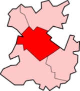
The Borough of Shrewsbury and Atcham covered 602 square kilometres (232.4 sq mi), which was 19% of the non-metropolitan county of Shropshire. To the north of the borough was the North Shropshire
district and the Borough of Oswestry
and to the south were the South Shropshire
and Bridgnorth
districts. The borough lay in the middle of Shropshire and on the border with Wales
. A 2006 estimate put the population
of the borough at 95,900 (this accounted for approx 40% of the total population for the non-metropolitan county).
The River Severn
runs through the area and in recent years (1998, 2000 twice, 2002, 2004, 2006, 2007) has brought severe and frequent flooding to parts of Shrewsbury and large areas of the countryside.
The district and its council was abolished on 1 April 2009 when the new Shropshire unitary authority was established, as part of the 2009 structural changes to local government in England
. The Central area committee
of the new Shropshire Council
covers exactly the same area as the borough did.
when the municipal borough
of Shrewsbury
was merged with Atcham Rural District, to form a new non-metropolitan district. This was initially called Shrewsbury, but was renamed Shrewsbury and Atcham on 12 June 1974 by the new council.
In 2004, when the borough council moved to their new Guildhall, it was suggested that it revert its name to simply "Shrewsbury Borough Council" - this never happened though, as the borough covers a wide area of countryside beyond the town of Shrewsbury and many felt that it should keep its historical name too.
The borough unsuccessfully applied for city status
in the 2000 and 2002 competitions.
The Conservative group was therefore the largest, with a majority, and had control of the council.
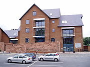 The headquarters of the borough council were on Frankwell Quay in Frankwell
, Shrewsbury, and can be accessed from the town centre by the Frankwell suspension footbridge. The new Guildhall lies near to the River Severn, although it is protected firstly by the flood defences built to defend Frankwell and then also by its own flood defences. Three flagpoles outside the Guildhall fly the flag of St. George, the Union Flag
and a flag depicting the Salopian Crest.
The borough council moved to the present Guildhall on March 19 2004 from the old Guildhall, now known as "Newport House" (which was its original name before it became a Guildhall), on Dogpole. Newport House has since been converted into a residential building.
was owned by the borough council, as was the town museum and art gallery, which is located in the 'Rowley's House' building. The council also owned various car parks, offices, some public conveniences, large areas of parkland and a number of the town's bridges. Ownership of two main entertainment venues was also held by the council: The Music Hall
, which holds the town theatre, its tourist information centre and a cafe, and The Old Market Hall, which was recently renovated to house a small cinema and cafe. The Bear Steps buildings were also owned by the council, although they are occupied by the town's civic society. The council once owned the Clive House Museum, but this was sold off and is now no longer a museum.
The borough council's housing stock was sold off in 2001 to a private social housing company, Severnside. The council earned some £60 million from this sale and this money has been used in part to buy and build their new Guildhall, build the new sports facilities at Sundorne and other large projects around the town, which are either under way or proposed.
but the urban part of the borough (the town of Shrewsbury) was unparished
until 2008. A town council for Shrewsbury was established in 2009 - the Mayor of Shrewsbury and Atcham Borough was also mayor for the town. There continues to be a Town Clerk however, as well as other ceremonial posts such as the sword bearer and mace bearers. The 40 councillors of the borough council represented wards (such as Sundorne
ward) and a Mayor
and Deputy Mayor were appointed by the council every year. The Mayor chaired full council meetings, which took place 6/7 times a year, and also had ceremonial duties. The administrative side of the council was headed by the Leader of the council (normally the leader of the party with the most councillors) and there was a permanent head of the local civil service
, the Chief Executive.
was voted in as a Labour candidate in the 2001 general election
and stood down before the 2005 general election, when the Conservative Daniel Kawczynski
won the seat.
of Shrewsbury since at least 1638. In 1974, after the local government re-organisation, the style changed to "Mayor of Shrewsbury and Atcham Borough". The last Mayor of Shrewsbury and Atcham was Cllr Anne Chebsey.
It is customary today that a Mayor is in office for only one year and that the Deputy Mayor becomes Mayor. The position of Mayor is non-political and councillors were elected to be Deputy Mayor (and then usually a year later, Mayor) on basis of seniority. For example, in 2004-2005, both the Mayor and Deputy Mayor were Liberal Democrats, but control of the council was Conservative. A Mayor could come from outside the town of Shrewsbury - the only rule was that he or she was a Shrewsbury and Atcham Borough councillor.
Both the Mayor and Deputy Mayor wore their traditional "chains of office" at ceremonial occasions, which many mayors and chairmen of towns, boroughs and counties in England have. The Mayor was given the prefix title of "The Right Worshipful".
Non-metropolitan district
Non-metropolitan districts, or colloquially shire districts, are a type of local government district in England. As created, they are sub-divisions of non-metropolitan counties in a so-called "two-tier" arrangement...
with borough
Borough
A borough is an administrative division in various countries. In principle, the term borough designates a self-governing township although, in practice, official use of the term varies widely....
status in Shropshire
Shropshire
Shropshire is a county in the West Midlands region of England. For Eurostat purposes, the county is a NUTS 3 region and is one of four counties or unitary districts that comprise the "Shropshire and Staffordshire" NUTS 2 region. It borders Wales to the west...
, England
England
England is a country that is part of the United Kingdom. It shares land borders with Scotland to the north and Wales to the west; the Irish Sea is to the north west, the Celtic Sea to the south west, with the North Sea to the east and the English Channel to the south separating it from continental...
.
Shrewsbury
Shrewsbury
Shrewsbury is the county town of Shropshire, in the West Midlands region of England. Lying on the River Severn, it is a civil parish home to some 70,000 inhabitants, and is the primary settlement and headquarters of Shropshire Council...
was the only town in the borough; Atcham
Atcham
Atcham is a village, ecclesiastical parish and civil parish in Shropshire, England. It is situated on the B4380 , 5 miles south east of Shrewsbury. The River Severn flows around the village...
, although itself only a village, was included in the name as a reflection of the incorporation into the borough of the former Atcham Rural District. Other notable villages included Bayston Hill
Bayston Hill
Bayston Hill is a large village and civil parish in central Shropshire, England. It is south of the county town Shrewsbury and located on the main A49 road, the Shrewsbury to Hereford road....
, Bomere Heath
Bomere Heath
Bomere Heath is a village in Shropshire, England lying north of the county town of Shrewsbury and in between Baschurch and Harlescott. It is situated between the A528 road and Berwick Road...
, Condover
Condover
Condover is a village and civil parish in Shropshire, England. It lies 4.7 miles south of the county town of Shrewsbury, and just east of the A49. The Cound Brook flows through the village on its way from the Stretton Hills to a confluence with the River Severn...
, Cressage
Cressage
Cressage is a village and civil parish in Shropshire, England. It lies on the junction of the A458 and B4380 roads and the River Severn flows around its northern boundary. The Royal Mail postcode begins SY5...
, Cross Houses
Cross Houses
Cross Houses is a village in Shropshire, England, the largest village in the Parish of Berrington. It is located on the A458 road, 4 miles SE of Shrewsbury. It was once served by Berrington railway station, which despite the name was much closer to Cross Houses than to its namesake.The village has...
, Ford
Ford, Shropshire
Ford is a village and civil parish in Shropshire, England.It is west of the county town of Shrewsbury, just off the A458 and near to the River Severn, at . The Royal Mail postcode is SY5. There is one pub in Ford, The Cross Gates, to the west. The Pavement Gates , is now an Indian restaurant called...
, Minsterley
Minsterley
Minsterley is a village and civil parish in Shropshire, England. It is home to a large dairy operated by Uniq foods.The dairy currently employs nearly 500 people...
, Nesscliffe
Nesscliffe
Nesscliffe is a village in Shropshire, England.The A5 road runs around the village on a new dual-carriageway by-pass and nearby is a small British Army base. It is also the site of a cave used by the highwayman, Humphrey Kynaston. This now forms part of the Nesscliffe Hill Country Park. The village...
, Pontesbury
Pontesbury
Pontesbury is a large village and civil parish in Shropshire and is approximately eight miles southwest of the county town of Shrewsbury. The village of Minsterley is just over a mile further southwest. The A488 road runs through the village, on its way from Shrewsbury to Bishop's Castle...
, Uffington
Uffington, Shropshire
Uffington is a village in the English county of Shropshire. It lies between Haughmond Hill and the River Severn, 3 miles east from the town centre of Shrewsbury, at .Uffington is home to a church and a pub, the Corbet Arms...
and Westbury
Westbury, Shropshire
Westbury is a village and parish in Shropshire, England. It lies 8 miles west of the town of Shrewsbury, very close to the Wales-England border.During the Roman settlement of Britain it was an outpost of Wroxeter....
.
The Borough of Shrewsbury and Atcham covered 602 square kilometres (232.4 sq mi), which was 19% of the non-metropolitan county of Shropshire. To the north of the borough was the North Shropshire
North Shropshire
North Shropshire was a local government district in Shropshire, England. The district council was based at Edinburgh House, in Wem. Other settlements included the towns of Ellesmere, Market Drayton, Wem and Whitchurch, as well as the large villages of Shawbury and Baschurch...
district and the Borough of Oswestry
Oswestry (borough)
Oswestry was a small local government district with borough status in Shropshire, England. It was the smallest of the five districts of Shropshire in terms of both population and land area....
and to the south were the South Shropshire
South Shropshire
South Shropshire was, between 1974 and 2009, a local government district in south west Shropshire, England.South Shropshire was the most rural district of one of the UK's most rural counties, the population of the district was 40,410 in 2001 spread out over 1,027 km² of forest, mountains,...
and Bridgnorth
Bridgnorth (district)
Bridgnorth District was, between 1974 and 2009, a local government district in Shropshire, England. Its main town was Bridgnorth and other towns in its area were Much Wenlock, Shifnal and Broseley. The villages of Albrighton and Sheriffhales as well as RAF Cosford were also in the district.The...
districts. The borough lay in the middle of Shropshire and on the border with Wales
Wales
Wales is a country that is part of the United Kingdom and the island of Great Britain, bordered by England to its east and the Atlantic Ocean and Irish Sea to its west. It has a population of three million, and a total area of 20,779 km²...
. A 2006 estimate put the population
Population
A population is all the organisms that both belong to the same group or species and live in the same geographical area. The area that is used to define a sexual population is such that inter-breeding is possible between any pair within the area and more probable than cross-breeding with individuals...
of the borough at 95,900 (this accounted for approx 40% of the total population for the non-metropolitan county).
The River Severn
River Severn
The River Severn is the longest river in Great Britain, at about , but the second longest on the British Isles, behind the River Shannon. It rises at an altitude of on Plynlimon, Ceredigion near Llanidloes, Powys, in the Cambrian Mountains of mid Wales...
runs through the area and in recent years (1998, 2000 twice, 2002, 2004, 2006, 2007) has brought severe and frequent flooding to parts of Shrewsbury and large areas of the countryside.
The district and its council was abolished on 1 April 2009 when the new Shropshire unitary authority was established, as part of the 2009 structural changes to local government in England
2009 structural changes to local government in England
Structural changes to local government in England were effected on 1 April 2009, whereby a number of new unitary authorities were created in parts of the country which previously operated a 'two-tier' system of counties and districts...
. The Central area committee
Area committee
Many large local government councils in the United Kingdom have a system of area committees, with responsibility for services in a particular part of the area covered by the council....
of the new Shropshire Council
Shropshire Council
Shropshire Council is a unitary authority in Shropshire, United Kingdom.It replaced the former two-tier local government structure in the non-metropolitan county of Shropshire on 1 April 2009, which involved its immediate predecessor, Shropshire County Council, and five non-metropolitan districts -...
covers exactly the same area as the borough did.
History
The borough was formed on 1 April 1974, under the Local Government Act 1972Local Government Act 1972
The Local Government Act 1972 is an Act of Parliament in the United Kingdom that reformed local government in England and Wales on 1 April 1974....
when the municipal borough
Municipal borough
Municipal boroughs were a type of local government district which existed in England and Wales between 1835 and 1974, in Northern Ireland from 1840 to 1973 and in the Republic of Ireland from 1840 to 2002...
of Shrewsbury
Shrewsbury
Shrewsbury is the county town of Shropshire, in the West Midlands region of England. Lying on the River Severn, it is a civil parish home to some 70,000 inhabitants, and is the primary settlement and headquarters of Shropshire Council...
was merged with Atcham Rural District, to form a new non-metropolitan district. This was initially called Shrewsbury, but was renamed Shrewsbury and Atcham on 12 June 1974 by the new council.
In 2004, when the borough council moved to their new Guildhall, it was suggested that it revert its name to simply "Shrewsbury Borough Council" - this never happened though, as the borough covers a wide area of countryside beyond the town of Shrewsbury and many felt that it should keep its historical name too.
The borough unsuccessfully applied for city status
City status in the United Kingdom
City status in the United Kingdom is granted by the British monarch to a select group of communities. The holding of city status gives a settlement no special rights other than that of calling itself a "city". Nonetheless, this appellation carries its own prestige and, consequently, competitions...
in the 2000 and 2002 competitions.
Population
| Year | 1801 | 1811 | 1821 | 1831 | 1841 | 1851 | 1861 | 1871 | 1881 | 1891 | 1901 | 1911 | 1921 | 1931 | 1941 | 1951 | 1961 | 1971 | 1981 | 1991 | 2001 |
|---|---|---|---|---|---|---|---|---|---|---|---|---|---|---|---|---|---|---|---|---|---|
| Population | 31,280 | 34,158 | 38,263 | 40,480 | 41,858 | 43,818 | 46,261 | 48,704 | 51,146 | 50,678 | 52,181 | 53,729 | 55,481 | 57,290 | 62,398 | 67,965 | 74,831 | 82,392 | 85,136 | 92,347 | 95,896 |
| Population figures for Shrewsbury & Atcham borough. Source: A Vision of Britain through Time | |||||||||||||||||||||
Councillors
The last council had forty elected members, called councillors, of which 22 were Conservative, 10 were Labour, 5 were Liberal Democrat and 3 were Independents.The Conservative group was therefore the largest, with a majority, and had control of the council.
Headquarters
Frankwell
Frankwell is a district of the town of Shrewsbury, in Shropshire, England. It lies adjacent to the River Severn, to the northwest of the town centre, and is one of Shrewsbury's oldest suburbs....
, Shrewsbury, and can be accessed from the town centre by the Frankwell suspension footbridge. The new Guildhall lies near to the River Severn, although it is protected firstly by the flood defences built to defend Frankwell and then also by its own flood defences. Three flagpoles outside the Guildhall fly the flag of St. George, the Union Flag
Union Flag
The Union Flag, also known as the Union Jack, is the flag of the United Kingdom. It retains an official or semi-official status in some Commonwealth Realms; for example, it is known as the Royal Union Flag in Canada. It is also used as an official flag in some of the smaller British overseas...
and a flag depicting the Salopian Crest.
The borough council moved to the present Guildhall on March 19 2004 from the old Guildhall, now known as "Newport House" (which was its original name before it became a Guildhall), on Dogpole. Newport House has since been converted into a residential building.
Property
The borough council owned much land and property in the Shrewsbury and Atcham area. Shrewsbury CastleShrewsbury Castle
Shrewsbury Castle is a red sandstone castle in Shrewsbury, Shropshire, England. It stands on a hill in the neck of the meander of the River Severn on which the town originally developed. The castle is situated directly above Shrewsbury railway station....
was owned by the borough council, as was the town museum and art gallery, which is located in the 'Rowley's House' building. The council also owned various car parks, offices, some public conveniences, large areas of parkland and a number of the town's bridges. Ownership of two main entertainment venues was also held by the council: The Music Hall
Music Hall, Shrewsbury
The Music Hall in Shrewsbury, England, is a large Victorian building owned by Shropshire Council and currently houses the town's theatre and central Visitor Information Centre, as well as a cafe and some council offices....
, which holds the town theatre, its tourist information centre and a cafe, and The Old Market Hall, which was recently renovated to house a small cinema and cafe. The Bear Steps buildings were also owned by the council, although they are occupied by the town's civic society. The council once owned the Clive House Museum, but this was sold off and is now no longer a museum.
The borough council's housing stock was sold off in 2001 to a private social housing company, Severnside. The council earned some £60 million from this sale and this money has been used in part to buy and build their new Guildhall, build the new sports facilities at Sundorne and other large projects around the town, which are either under way or proposed.
Administration
The rural part of the borough has always been parishedCivil parish
In England, a civil parish is a territorial designation and, where they are found, the lowest tier of local government below districts and counties...
but the urban part of the borough (the town of Shrewsbury) was unparished
Unparished area
In England, an unparished area is an area that is not covered by a civil parish. Most urbanised districts of England are either entirely or partly unparished. Many towns and some cities in otherwise rural districts are also unparished areas and therefore no longer have a town council or city...
until 2008. A town council for Shrewsbury was established in 2009 - the Mayor of Shrewsbury and Atcham Borough was also mayor for the town. There continues to be a Town Clerk however, as well as other ceremonial posts such as the sword bearer and mace bearers. The 40 councillors of the borough council represented wards (such as Sundorne
Sundorne
Sundorne is a suburb of the town of Shrewsbury, county town of Shropshire. It is located 2 km north of the town centre. The B5062 road begins at Heathgates Roundabout and is called Sundorne Road in the Sundorne area, before crossing the Shrewsbury by-pass at Sundorne Roundabout and heading east...
ward) and a Mayor
Mayors in the United Kingdom
In England, the office of mayor or lord mayor had long been ceremonial posts, with few or no duties attached to it. A mayor's term of office denotes the municipal year. The most famous example is that of the Lord Mayor of the City of London....
and Deputy Mayor were appointed by the council every year. The Mayor chaired full council meetings, which took place 6/7 times a year, and also had ceremonial duties. The administrative side of the council was headed by the Leader of the council (normally the leader of the party with the most councillors) and there was a permanent head of the local civil service
Civil service
The term civil service has two distinct meanings:* A branch of governmental service in which individuals are employed on the basis of professional merit as proven by competitive examinations....
, the Chief Executive.
Wards
There were 24 wards in total. The Shrewsbury Urban area is shown in Orange, within the larger Shrewsbury & Atcham district. 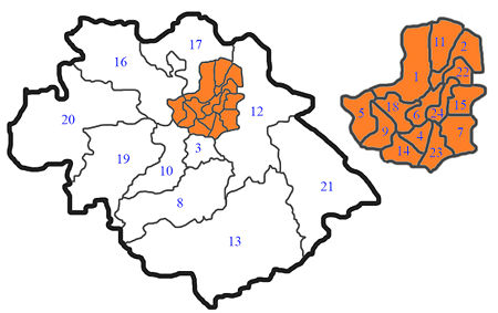 |
1 Bagley 2 Battlefield and Heathgates 3 Bayston Hill 4 Belle Vue 5 Bowbrook 6 Castlefields and Quarry 7 Column 8 Condover 9 Copthorne 10 Hanwood and Longden 11 Harlescott 12 Haughmond and Attingham |
13 Lawley 14 Meole Brace 15 Monkmoor 16 Montford 17 Pimhill 18 Porthill 19 Rea Valley 20 Rowton 21 Severn Valley 22 Sundorne 23 Sutton and Reabrook 24 Underdale |
Constituency
The former borough area is also a United Kingdom Parliament constituency, returning an MP. The boundaries of the borough and the constituency are the same, which is convenient. Paul MarsdenPaul Marsden
Paul William Barry Marsden is a British writer, businessman and former politician. He was the Member of Parliament for Shrewsbury and Atcham from 1997 until 2005...
was voted in as a Labour candidate in the 2001 general election
United Kingdom general elections
This is a list of United Kingdom general elections since the first in 1802. The members of the 1801–1802 Parliament had been elected to the former Parliament of Great Britain and Parliament of Ireland, before being co-opted to serve in the first Parliament of the United Kingdom, so that Parliament...
and stood down before the 2005 general election, when the Conservative Daniel Kawczynski
Daniel Kawczynski
Daniel Robert Kawczynski is the Conservative Party Member for Parliament for Shrewsbury and Atcham in Shropshire, England.-Biography:...
won the seat.
Mayors
There has been a continuous succession of MayorsMayors in the United Kingdom
In England, the office of mayor or lord mayor had long been ceremonial posts, with few or no duties attached to it. A mayor's term of office denotes the municipal year. The most famous example is that of the Lord Mayor of the City of London....
of Shrewsbury since at least 1638. In 1974, after the local government re-organisation, the style changed to "Mayor of Shrewsbury and Atcham Borough". The last Mayor of Shrewsbury and Atcham was Cllr Anne Chebsey.
It is customary today that a Mayor is in office for only one year and that the Deputy Mayor becomes Mayor. The position of Mayor is non-political and councillors were elected to be Deputy Mayor (and then usually a year later, Mayor) on basis of seniority. For example, in 2004-2005, both the Mayor and Deputy Mayor were Liberal Democrats, but control of the council was Conservative. A Mayor could come from outside the town of Shrewsbury - the only rule was that he or she was a Shrewsbury and Atcham Borough councillor.
Both the Mayor and Deputy Mayor wore their traditional "chains of office" at ceremonial occasions, which many mayors and chairmen of towns, boroughs and counties in England have. The Mayor was given the prefix title of "The Right Worshipful".