

South Shropshire
Encyclopedia
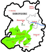
South Shropshire was, between 1974 and 2009, a local government district
in south west Shropshire
, England.
South Shropshire was the most rural
district of one of the UK
's most rural counties, the population
of the district was 40,410 in 2001 spread out over 1,027 km² of forest
, mountain
s, moorland
s, hill
s and mixed quality farmland. It bordered the unitary authority of Powys
in Wales
, which it closely resembles, economically, socially, culturally and historically. 65% of the district is part of the Shropshire Hills Area of Outstanding Natural Beauty
. Only the towns of Ludlow
and Church Stretton
have populations in excess of 3000. Other towns formerly in the district were Clun
, Bishop's Castle
, Cleobury Mortimer
and Craven Arms
.
The district was formed by the merger of the rural district
s of Clun and Bishop's Castle
and Ludlow
in 1974, under the Local Government Act 1972
.
The district and its council were abolished on 1 April 2009 when the new Shropshire unitary authority
was established, as part of the 2009 structural changes to local government in England
.
, partly due to the decline in the economic significance of farming and also the decline and subsequent end of local lead and coal mining
industry. In addition to tourism, some light industry
did exist in the district, in the Church Stretton
and Ludlow
areas, and in Burford, near Tenbury Wells.
Some statistics for the local area suggest that wages
are "low", but also that the rate of unemployment
is below average.
Additionally, the local demographics
show a large economic gap between affluent residents and poorer communities. Many of the affluent residents have moved into the area from other places, such as South East England
on their retirement. This continues an older trend whose root was initially in the imbalance of wealth associated with the farming economy previously prevalent in the area.
 The District of South Shropshire covered an area of 1,028 square kilometres, or 397 square miles (1,028.2 km²), which was roughly one third of the administrative county of Shropshire as of 2008.
South Shropshire is a land of mountains, valleys, hills, moors, forests and low grade farmland. The landscape is often rugged, with crags and rock outcrops very common, especially in the west and around the Clee Hills
, and was for the most part gouged by glaciers during the ice age
. It contains a myriad of rock types, and is widely regarded as the geological
capital of the UK, with Wenlock Edge
being especially highly regarded by geologists.
See the Shropshire Hills AONB
(Area of Outstanding Natural Beauty) for more about the natural geography of the area.
quarrying in the Apedale.
The area seems to have been settled by the Ordovices
, an Iron Age
tribe of people in the last millennium BC, and was a stronghold of the Celtic chieftain Caractacus (Caer Caradoc is said to be named after him).
The area was probably part of the "Military" division of the Roman
occupation and locals claim that the Romans mined lead in the north west of the district.
In the Early Middle Ages
, the area was a battleground between the Welsh and the Anglo Saxon Kingdom of Mercia
and Offa's Dyke
, which is partially in the district, is a permanent reminder of the areas border status.
In the Middle Ages
, South Shropshire was part of the Welsh Marches
, a lawless area ruled by tyrannical feudal lords
, who as Marcher Lords had de facto independence from the King of England.
It has been remarked that the attitude of the time lives on in the areas mistrust of outside control.
During the English Civil War
the area was generally spared from fighting, although there was a small massacre at Hopton Castle
.
During the Industrial Revolution
, coal was mined around Clee Hill and lead was mined near the border with Wales, e.g. at Snailbeach
. Church Stretton was a centre of textile manufacture and Ludlow thrived on the malting trade, while the rest of the area was populated by smallholders. The economy of the area was fragile, and most industry in the area had collapsed by 1900.
, with the second largest party being the Liberal Democrats. A number of independent politicians also held seats in the council. The Labour Party
had not contested recent elections within the district.
http://www.britishgasnews.co.uk/managed_content/files/pdf/greenCity.pdf showed that housing in South Shropshire produced the 13th highest average carbon emissions in the country at 7,156 kg of carbon dioxide
per dwelling.
Non-metropolitan district
Non-metropolitan districts, or colloquially shire districts, are a type of local government district in England. As created, they are sub-divisions of non-metropolitan counties in a so-called "two-tier" arrangement...
in south west Shropshire
Shropshire
Shropshire is a county in the West Midlands region of England. For Eurostat purposes, the county is a NUTS 3 region and is one of four counties or unitary districts that comprise the "Shropshire and Staffordshire" NUTS 2 region. It borders Wales to the west...
, England.
South Shropshire was the most rural
Rural
Rural areas or the country or countryside are areas that are not urbanized, though when large areas are described, country towns and smaller cities will be included. They have a low population density, and typically much of the land is devoted to agriculture...
district of one of the UK
United Kingdom
The United Kingdom of Great Britain and Northern IrelandIn the United Kingdom and Dependencies, other languages have been officially recognised as legitimate autochthonous languages under the European Charter for Regional or Minority Languages...
's most rural counties, the population
Population
A population is all the organisms that both belong to the same group or species and live in the same geographical area. The area that is used to define a sexual population is such that inter-breeding is possible between any pair within the area and more probable than cross-breeding with individuals...
of the district was 40,410 in 2001 spread out over 1,027 km² of forest
Forest
A forest, also referred to as a wood or the woods, is an area with a high density of trees. As with cities, depending where you are in the world, what is considered a forest may vary significantly in size and have various classification according to how and what of the forest is composed...
, mountain
Mountain
Image:Himalaya_annotated.jpg|thumb|right|The Himalayan mountain range with Mount Everestrect 58 14 160 49 Chomo Lonzorect 200 28 335 52 Makalurect 378 24 566 45 Mount Everestrect 188 581 920 656 Tibetan Plateaurect 250 406 340 427 Rong River...
s, moorland
Moorland
Moorland or moor is a type of habitat, in the temperate grasslands, savannas, and shrublands biome, found in upland areas, characterised by low-growing vegetation on acidic soils and heavy fog...
s, hill
Hill
A hill is a landform that extends above the surrounding terrain. Hills often have a distinct summit, although in areas with scarp/dip topography a hill may refer to a particular section of flat terrain without a massive summit A hill is a landform that extends above the surrounding terrain. Hills...
s and mixed quality farmland. It bordered the unitary authority of Powys
Powys
Powys is a local-government county and preserved county in Wales.-Geography:Powys covers the historic counties of Montgomeryshire and Radnorshire, most of Brecknockshire , and a small part of Denbighshire — an area of 5,179 km², making it the largest county in Wales by land area.It is...
in Wales
Wales
Wales is a country that is part of the United Kingdom and the island of Great Britain, bordered by England to its east and the Atlantic Ocean and Irish Sea to its west. It has a population of three million, and a total area of 20,779 km²...
, which it closely resembles, economically, socially, culturally and historically. 65% of the district is part of the Shropshire Hills Area of Outstanding Natural Beauty
Shropshire Hills AONB
The Shropshire Hills area is designated as an Area of Outstanding Natural Beauty , in the English county of Shropshire, close to its border with Wales. Designated in 1958 , the area encompasses of land primarily in south-west Shropshire...
. Only the towns of Ludlow
Ludlow
Ludlow is a market town in Shropshire, England close to the Welsh border and in the Welsh Marches. It lies within a bend of the River Teme, on its eastern bank, forming an area of and centred on a small hill. Atop this hill is the site of Ludlow Castle and the market place...
and Church Stretton
Church Stretton
Church Stretton is a small town and civil parish in Shropshire, England. The population of the town was recorded as 2,789 in 2001, whilst the population of the wider parish was recorded as 4,186...
have populations in excess of 3000. Other towns formerly in the district were Clun
Clun
Clun is a small town in Shropshire, England. The town is located entirely in the Shropshire Hills Area of Outstanding Natural Beauty. The 2001 census recorded 642 people living in the town...
, Bishop's Castle
Bishop's Castle
Bishop's Castle is a small market town in Shropshire, England, and formerly its smallest borough. According to the 2001 census it had a population of 1,630. Bishop's Castle is east of the Wales-England border, about north-west of Ludlow and about south-west of Shrewsbury. To the south is Clun...
, Cleobury Mortimer
Cleobury Mortimer
Cleobury Mortimer is a small rural market town in Shropshire, England. The town's parish has a population of 1,962 according to the 2001 census. Although sometimes regarded as a village, it is in fact the second smallest town in Shropshire , having been granted a town charter in 1253.Several...
and Craven Arms
Craven Arms
Craven Arms is a small town and civil parish in Shropshire, England, located on the A49 road and the Welsh Marches railway line, which connect it north and south to the larger towns of Shrewsbury and Ludlow respectively. The Heart of Wales railway line joins the Welsh Marches line at Craven Arms...
.
The district was formed by the merger of the rural district
Rural district
Rural districts were a type of local government area – now superseded – established at the end of the 19th century in England, Wales, and Ireland for the administration of predominantly rural areas at a level lower than that of the administrative counties.-England and Wales:In England...
s of Clun and Bishop's Castle
Clun and Bishop's Castle Rural District
Clun and Bishop's Castle was a rural district in Shropshire, England from 1894 to 1974.It was created by the Local Government Act 1894 as the Clun Rural District, based on the Clun rural sanitary district...
and Ludlow
Ludlow Rural District
Ludlow was a rural district in Shropshire, England from 1894 to 1974.It was created by the Local Government Act 1894 from the Ludlow rural sanitary district. It was enlarged in 1934 under a County Review Order by taking in the disbanded Burford Rural District and parts of the Church Stretton Rural...
in 1974, under the Local Government Act 1972
Local Government Act 1972
The Local Government Act 1972 is an Act of Parliament in the United Kingdom that reformed local government in England and Wales on 1 April 1974....
.
The district and its council were abolished on 1 April 2009 when the new Shropshire unitary authority
Unitary authority
A unitary authority is a type of local authority that has a single tier and is responsible for all local government functions within its area or performs additional functions which elsewhere in the relevant country are usually performed by national government or a higher level of sub-national...
was established, as part of the 2009 structural changes to local government in England
2009 structural changes to local government in England
Structural changes to local government in England were effected on 1 April 2009, whereby a number of new unitary authorities were created in parts of the country which previously operated a 'two-tier' system of counties and districts...
.
Economics and Demographics
Economically the district was largely dependent on tourismTourism in England
Tourism plays a significant part in the economic life of England.-Cultural and heritage tourism:England's long history and pervasive culture spread worldwide through the English language and colonialism make England a popular tourist destination, particularly in London...
, partly due to the decline in the economic significance of farming and also the decline and subsequent end of local lead and coal mining
Coal mining
The goal of coal mining is to obtain coal from the ground. Coal is valued for its energy content, and since the 1880s has been widely used to generate electricity. Steel and cement industries use coal as a fuel for extraction of iron from iron ore and for cement production. In the United States,...
industry. In addition to tourism, some light industry
Light industry
Light industry is usually less capital intensive than heavy industry, and is more consumer-oriented than business-oriented...
did exist in the district, in the Church Stretton
Church Stretton
Church Stretton is a small town and civil parish in Shropshire, England. The population of the town was recorded as 2,789 in 2001, whilst the population of the wider parish was recorded as 4,186...
and Ludlow
Ludlow
Ludlow is a market town in Shropshire, England close to the Welsh border and in the Welsh Marches. It lies within a bend of the River Teme, on its eastern bank, forming an area of and centred on a small hill. Atop this hill is the site of Ludlow Castle and the market place...
areas, and in Burford, near Tenbury Wells.
Some statistics for the local area suggest that wages
Income in the United Kingdom
In terms of global poverty criteria, the United Kingdom is a wealthy country, with virtually no people living on less than £4 a day. There is both significant income redistribution and income inequality. Thus in 2008/09 income in the top and bottom fifth of households was £73,800 and £5,000...
are "low", but also that the rate of unemployment
Unemployment
Unemployment , as defined by the International Labour Organization, occurs when people are without jobs and they have actively sought work within the past four weeks...
is below average.
Additionally, the local demographics
Demographics
Demographics are the most recent statistical characteristics of a population. These types of data are used widely in sociology , public policy, and marketing. Commonly examined demographics include gender, race, age, disabilities, mobility, home ownership, employment status, and even location...
show a large economic gap between affluent residents and poorer communities. Many of the affluent residents have moved into the area from other places, such as South East England
South East England
South East England is one of the nine official regions of England, designated in 1994 and adopted for statistical purposes in 1999. It consists of Berkshire, Buckinghamshire, East Sussex, Hampshire, Isle of Wight, Kent, Oxfordshire, Surrey and West Sussex...
on their retirement. This continues an older trend whose root was initially in the imbalance of wealth associated with the farming economy previously prevalent in the area.
Geography
South Shropshire is a land of mountains, valleys, hills, moors, forests and low grade farmland. The landscape is often rugged, with crags and rock outcrops very common, especially in the west and around the Clee Hills
Clee Hills
The Clee Hills are a range of hills in Shropshire, England near Ludlow, consisting of Brown Clee Hill , the highest peak in Shropshire, and Titterstone Clee Hill...
, and was for the most part gouged by glaciers during the ice age
Ice age
An ice age or, more precisely, glacial age, is a generic geological period of long-term reduction in the temperature of the Earth's surface and atmosphere, resulting in the presence or expansion of continental ice sheets, polar ice sheets and alpine glaciers...
. It contains a myriad of rock types, and is widely regarded as the geological
Geology of Shropshire
Shropshire's Geology is very diverse and most rock types found in the British Isles can be found in the county too. There is also a large amount of mineral wealth, including lead, coal and iron in the county, which perhaps helped the area develop the first industry of the industrial revolution, in...
capital of the UK, with Wenlock Edge
Wenlock Edge
Wenlock Edge is a limestone escarpment near Much Wenlock, Shropshire, England. It is long and runs from South West to North East between Craven Arms and Much Wenlock. It is roughly 330 metres high...
being especially highly regarded by geologists.
See the Shropshire Hills AONB
Shropshire Hills AONB
The Shropshire Hills area is designated as an Area of Outstanding Natural Beauty , in the English county of Shropshire, close to its border with Wales. Designated in 1958 , the area encompasses of land primarily in south-west Shropshire...
(Area of Outstanding Natural Beauty) for more about the natural geography of the area.
History
South Shropshire is littered with ancient monuments, with Mitchells Fold on the Welsh border being the most notable, and there is evidence of NeolithicNeolithic
The Neolithic Age, Era, or Period, or New Stone Age, was a period in the development of human technology, beginning about 9500 BC in some parts of the Middle East, and later in other parts of the world. It is traditionally considered as the last part of the Stone Age...
quarrying in the Apedale.
The area seems to have been settled by the Ordovices
Ordovices
The Ordovices were one of the Celtic tribes living in Great Britain, before the Roman invasion of Britain. Its tribal lands were located in present day Wales and England between the Silures to the south and the Deceangli to the north-east...
, an Iron Age
Iron Age
The Iron Age is the archaeological period generally occurring after the Bronze Age, marked by the prevalent use of iron. The early period of the age is characterized by the widespread use of iron or steel. The adoption of such material coincided with other changes in society, including differing...
tribe of people in the last millennium BC, and was a stronghold of the Celtic chieftain Caractacus (Caer Caradoc is said to be named after him).
The area was probably part of the "Military" division of the Roman
Roman Britain
Roman Britain was the part of the island of Great Britain controlled by the Roman Empire from AD 43 until ca. AD 410.The Romans referred to the imperial province as Britannia, which eventually comprised all of the island of Great Britain south of the fluid frontier with Caledonia...
occupation and locals claim that the Romans mined lead in the north west of the district.
In the Early Middle Ages
Middle Ages
The Middle Ages is a periodization of European history from the 5th century to the 15th century. The Middle Ages follows the fall of the Western Roman Empire in 476 and precedes the Early Modern Era. It is the middle period of a three-period division of Western history: Classic, Medieval and Modern...
, the area was a battleground between the Welsh and the Anglo Saxon Kingdom of Mercia
Mercia
Mercia was one of the kingdoms of the Anglo-Saxon Heptarchy. It was centred on the valley of the River Trent and its tributaries in the region now known as the English Midlands...
and Offa's Dyke
Offa's Dyke
Offa's Dyke is a massive linear earthwork, roughly followed by some of the current border between England and Wales. In places, it is up to wide and high. In the 8th century it formed some kind of delineation between the Anglian kingdom of Mercia and the Welsh kingdom of Powys...
, which is partially in the district, is a permanent reminder of the areas border status.
In the Middle Ages
Middle Ages
The Middle Ages is a periodization of European history from the 5th century to the 15th century. The Middle Ages follows the fall of the Western Roman Empire in 476 and precedes the Early Modern Era. It is the middle period of a three-period division of Western history: Classic, Medieval and Modern...
, South Shropshire was part of the Welsh Marches
Welsh Marches
The Welsh Marches is a term which, in modern usage, denotes an imprecisely defined area along and around the border between England and Wales in the United Kingdom. The precise meaning of the term has varied at different periods...
, a lawless area ruled by tyrannical feudal lords
Feudalism
Feudalism was a set of legal and military customs in medieval Europe that flourished between the 9th and 15th centuries, which, broadly defined, was a system for ordering society around relationships derived from the holding of land in exchange for service or labour.Although derived from the...
, who as Marcher Lords had de facto independence from the King of England.
It has been remarked that the attitude of the time lives on in the areas mistrust of outside control.
During the English Civil War
English Civil War
The English Civil War was a series of armed conflicts and political machinations between Parliamentarians and Royalists...
the area was generally spared from fighting, although there was a small massacre at Hopton Castle
Hopton Castle
Hopton Castle is a small village and civil parish in Shropshire, England.The village grew up near to the keep of Hopton Castle, which was opened as a visitor attraction in 2011. Nearby is the hamlet of Hopton Heath, with its small station on the Heart of Wales Line...
.
During the Industrial Revolution
Industrial Revolution
The Industrial Revolution was a period from the 18th to the 19th century where major changes in agriculture, manufacturing, mining, transportation, and technology had a profound effect on the social, economic and cultural conditions of the times...
, coal was mined around Clee Hill and lead was mined near the border with Wales, e.g. at Snailbeach
Snailbeach
Snailbeach is a village in Shropshire, England, located near Shrewsbury at . The village was formerly home to a large lead mine.-Early history:A village was built for workers at the local lead mine - Snailbeach Mine, which reputedly dates back to Roman times...
. Church Stretton was a centre of textile manufacture and Ludlow thrived on the malting trade, while the rest of the area was populated by smallholders. The economy of the area was fragile, and most industry in the area had collapsed by 1900.
Politics
The last South Shropshire District Council was controlled by the Conservative PartyConservative Party (UK)
The Conservative Party, formally the Conservative and Unionist Party, is a centre-right political party in the United Kingdom that adheres to the philosophies of conservatism and British unionism. It is the largest political party in the UK, and is currently the largest single party in the House...
, with the second largest party being the Liberal Democrats. A number of independent politicians also held seats in the council. The Labour Party
Labour Party (UK)
The Labour Party is a centre-left democratic socialist party in the United Kingdom. It surpassed the Liberal Party in general elections during the early 1920s, forming minority governments under Ramsay MacDonald in 1924 and 1929-1931. The party was in a wartime coalition from 1940 to 1945, after...
had not contested recent elections within the district.
| Party | Seats |
|---|---|
| Liberal Democrat and Progressive | 11 |
| Conservative | 18 |
| Independent | 4 |
| Green | 1 |
| Total | 34 |
- Senior Councillors
- Council leader: Cecilia Mottley, C,
- Deputy leader: ?
Energy policy
In May 2006, a report commissioned by British GasCentrica
Centrica plc is a multinational utility company, based in the United Kingdom but also with interests in North America. Centrica is the largest supplier of gas to domestic customers in the UK, and one of the largest suppliers of electricity, operating under the trading names "Scottish Gas" in...
http://www.britishgasnews.co.uk/managed_content/files/pdf/greenCity.pdf showed that housing in South Shropshire produced the 13th highest average carbon emissions in the country at 7,156 kg of carbon dioxide
Carbon dioxide
Carbon dioxide is a naturally occurring chemical compound composed of two oxygen atoms covalently bonded to a single carbon atom...
per dwelling.
Various Statistics
| Population structure | |% |
|---|---|
| 0-4 | 5.2 |
| 5-15 | 11.8 |
| 16-19 | 5.1 |
| 20-29 | 7.7 |
| 30-44 | 19.5 |
| 45-retirement age | 25.3 |
| retirement age+ | 25.2 |
| Level of Employment 2001: | |% |
| Managers etc. | 14.7 |
| Professionals | 10.1 |
| Assoc. professional/technical | 10.2 |
| Admin and secretarial | 9.5 |
| Skilled manual | 20.3 |
| Personal service | 8.1 |
| Sales and customer service | 5.7 |
| Plant and machinery operatives | 8.4 |
| Elementary occupations | 13.1 |
| unemployed males | 2.5 |
| unemployed females | 1.1 |
| Employment by industry 2001: | |% |
| agriculture and forestry | 10.2 |
| energy and water | 0.9 |
| manufacturing | 14.1 |
| construction | 8.2 |
| services | 22.4 |
| transport and communications | 4.5 |
| finance | 11.8 |
| public sector | 22.7 |
| others | 5.1 |
| Sundry statistics 2001: | |% |
| In-migrants 1991-2001 | 10.2 |
| Visible minorities | 0.7 |