
Sedimentary budget
Encyclopedia

Sediment
Sediment is naturally occurring material that is broken down by processes of weathering and erosion, and is subsequently transported by the action of fluids such as wind, water, or ice, and/or by the force of gravity acting on the particle itself....
is dependent on the amount of sediment brought in to the system versus the amount of sediment that leaves the system. These inputs and outputs of sediment then equate to the total balance of the system and more than often reflect the amounts of erosion
Erosion
Erosion is when materials are removed from the surface and changed into something else. It only works by hydraulic actions and transport of solids in the natural environment, and leads to the deposition of these materials elsewhere...
or accretion
Accretion (coastal management)
Accretion is the process of coastal sediment returning to the visible portion of a beach or foreshore following a submersion event. A sustainable beach or foreshore often goes through a cycle of submersion during rough weather then accretion during calmer periods...
affecting the morphology of the coast.
To assess the sedimentary budget the coast has to be divided into two separate morphologies, commonly known as littoral cells and compartments. Sediment compartments can usually be defined as two rocky barriers which mark the ends of a beach and have a fixed sediment budget, although usually leaky to some extant. Littoral cells can either be free or fixed and can occupy a hierarchy of scales, from individual rip cells to entire beaches.
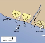
There are various types of natural sources and sinks within a coastal system. Sediment sources can include river transport, sea cliff erosion and longshore drift
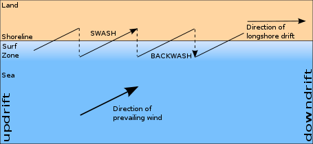
Longshore drift
Longshore drift consists of the transportation of sediments along a coast at an angle to the shoreline, which is dependent on prevailing wind direction, swash and backwash. This process occurs in the littoral zone, and in or within close proximity to the surf zone...
into an area. Sediment sinks can include longshore drift of sediment away from an area and sediment deposition in to an estuary
Estuary
An estuary is a partly enclosed coastal body of water with one or more rivers or streams flowing into it, and with a free connection to the open sea....
.
Anthropogenic activities can also influence sedimentary budgets; in particular damming of a river and in stream gravel mining of a river bed can reduce the sediment source to the coast. In contrast beach nourishment
Beach nourishment
Beach nourishment— also referred to as beach replenishment—describes a process by which sediment lost through longshore drift or erosion is replaced from sources outside of the eroding beach...
can increase sediment source.
In 1966, Bowen and Inman defined a littoral cell and separated sediment inputs, accretion by longshore drift and outputs.
Sedimentary budgets are used to assist in the management of beach erosion by trying to show the present sediment movement and forecast future sediment movement.
Feedback mechanisms
In order to understand the sedimentary budget of a coastal environment it is important to know the different types of feedback that can determine whether there is stability. When a beach environment is effected by wind, wave and tidal energy it responds with either positive or negative feedback which determines whether the system is balanced and in equilibriumHomeostasis
Homeostasis is the property of a system that regulates its internal environment and tends to maintain a stable, constant condition of properties like temperature or pH...
.
Negative feedback
Negative feedback
Negative feedback occurs when the output of a system acts to oppose changes to the input of the system, with the result that the changes are attenuated. If the overall feedback of the system is negative, then the system will tend to be stable.- Overview :...
is a stabilising mechanism acting to oppose changes to coastal morphology and establish equilibrium. A coastal environment in equilibrium is able to dissipate or reflect incoming energy without the occurrence of sediment input or output and change to morphology. For example; when a beach in equilibrium erodes during a storm it forms an offshore bar that in turn forces waves to break over it. By doing this the waves lose a lot of energy and dissipate before reaching the shoreline, significantly reducing further erosion. When the storm calms, the bar is then re-worked back on to the beach.
In contrast positive feedback
Positive feedback
Positive feedback is a process in which the effects of a small disturbance on a system include an increase in the magnitude of the perturbation. That is, A produces more of B which in turn produces more of A. In contrast, a system that responds to a perturbation in a way that reduces its effect is...
pushes a coastal system away from equilibrium by modifying its morphology until a threshold is reached, whereby a different type of response occurs. For example; if a storm event was to breach the foredune
Dune
In physical geography, a dune is a hill of sand built by wind. Dunes occur in different forms and sizes, formed by interaction with the wind. Most kinds of dunes are longer on the windward side where the sand is pushed up the dune and have a shorter "slip face" in the lee of the wind...
of a beach that is not in equilibrium, a vulnerable area would be created, which in turn would become susceptible to the formation of a blowout due to wind exploiting the absence of vegetation.
Sediment compartments and littoral cells
Compartmentalisation of the shore occurs where there are major obstacles or objects, especially headlands on deeply embayed coasts. The beaches that are the most enclosed are commonly known as pocket beaches. On these type of beaches the volume of sand remains constant and are closed compartments. Littoral cells can be defined as sediment within a coast that is circulated e.g. rip currents. Littoral cells usually develop on coast which are not impeded by headlands and where longshore currents are allowed to develop.Identifying littoral cells is crucial to determine the sediment budget of sandy coasts. In south-west Western Australia, large cuspate foreland
Cuspate foreland
Cuspate forelands, also known as cuspate barriers or Nesses in Britain, are geographical features found on coastlines and lakeshores that are created primarily by long shore drift. Formed by accretion and progradation of sand and shingle, they extend outwards from the shoreline in a triangular shape...
s and rocky headlands are thought to be boundaries for littoral cells. Boundaries of littoral cells have been defined using tracer studies of sediment movement, geomorphological observation and sedimentological description, heavy mineral sourcing, and analysis of the spatial distribution of wave flux along the shore.
Littoral cells are usually an area where changes in the volume of sediment directly affects changes in the coastline, and ideally they are defined to minimise longshore sediment exchange with other littoral cells, for example, a pocket beach surrounded by rocky headlands (which are presumed to exclude sediments). Sub-cells are usually defined to better measure the sediment budget of a coast with varying rates of accretion and erosion. The landward boundary of a littoral cell is usually the foot of a dune or cliff, however, the seaward boundary is difficult to define as mechanisms of sediment transport
Sediment transport
Sediment transport is the movement of solid particles , typically due to a combination of the force of gravity acting on the sediment, and/or the movement of the fluid in which the sediment is entrained...
here are poorly understood. There are three kinds of boundaries between littoral cells: longshore, landward, and seaward; across which sediment may enter the littoral cell or leave it by various processes. It is important to identify which processes operate on a particular littoral cell and also important to identify sediment sources and sinks, as by measuring the sediment gained or lost by these sources and sinks, a sediment budget can be determined.
Rivers
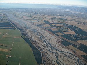
Waimakariri River
The Waimakariri River is the largest of the North Canterbury rivers, in the South Island of New Zealand. It flows for 151 kilometres in a generally southeastward direction from the Southern Alps across the Canterbury Plains to the Pacific Ocean....
on the coast of Canterbury, New Zealand produces 77% of sediment supplied to the Pegasus Bay
Pegasus Bay
Pegasus Bay is on the east coast of the South Island of New Zealand.-Location:The bay has a sandy beach and runs from Banks Peninsula to the Waipara River mouth...
coastline. This is not always the case with some rivers referred to as ‘small’ because they struggle to supply enough sediment to keep there coastlines from eroding, for example, the Rakaia River
Rakaia River
The Rakaia River is in the Canterbury Plains in New Zealand's South Island. The Rakaia River is one of the largest braided rivers in New Zealand...
South of Banks Peninsula
Banks Peninsula
Banks Peninsula is a peninsula of volcanic origin on the east coast of the South Island of New Zealand. It has an area of approximately and encompasses two large harbours and many smaller bays and coves...
in Canterbury, New Zealand.
The construction of river dams for flood control and hydropower
Hydropower
Hydropower, hydraulic power, hydrokinetic power or water power is power that is derived from the force or energy of falling water, which may be harnessed for useful purposes. Since ancient times, hydropower has been used for irrigation and the operation of various mechanical devices, such as...
reduces sediment supply to many coastlines due to the trapping of sediment and the decrease in flood peaks and flood intensity. In places such as Southern California
Southern California
Southern California is a megaregion, or megapolitan area, in the southern area of the U.S. state of California. Large urban areas include Greater Los Angeles and Greater San Diego. The urban area stretches along the coast from Ventura through the Southland and Inland Empire to San Diego...
of the United States, in particular the San Luis Rey River
San Luis Rey River
The San Luis Rey River is a river in northern San Diego County, California. The river's headwaters are in the Cleveland National Forest near Palomar Mountain. The river drains into the Pacific Ocean on the northern end of the city of Oceanside. The river is over long and drains...
, dams are built to control flooding of properties along the river. Ironically, in doing so, this is contributing to the damage of coastal properties due to a lack of sediment produced to protect the beaches. Another example is the Aswan Dam
Aswan Dam
The Aswan Dam is an embankment dam situated across the Nile River in Aswan, Egypt. Since the 1950s, the name commonly refers to the High Dam, which is larger and newer than the Aswan Low Dam, which was first completed in 1902...
constructed on the Nile River, Egypt
Egypt
Egypt , officially the Arab Republic of Egypt, Arabic: , is a country mainly in North Africa, with the Sinai Peninsula forming a land bridge in Southwest Asia. Egypt is thus a transcontinental country, and a major power in Africa, the Mediterranean Basin, the Middle East and the Muslim world...
in 1964. Prior to the construction of the Aswan Dam, the Nile River delivered 60-180 million tones of sediment and water to the Mediterranean Sea
Mediterranean Sea
The Mediterranean Sea is a sea connected to the Atlantic Ocean surrounded by the Mediterranean region and almost completely enclosed by land: on the north by Anatolia and Europe, on the south by North Africa, and on the east by the Levant...
every year. Sediment supply is now almost zero which has produced a significant imbalance to the near shore sedimentary budget, creating major erosion and shifting of sediment along the coast.
The effects of sediment trapping due to dams can be exacerbated when combined with other activities such as in-stream gravel mining. Excavation of gravel from a river bed forms pits within the channel profile which can trap much of the incoming bed load
Bed load
The term bed load or bedload describes particles in a flowing fluid that are transported along the bed. Bed load is complementary to suspended load and wash load.Bed load moves by rolling, sliding, and/or saltating ....
sediment, preventing or slowing it from reaching the coastline. Mining can also reducing the amount of overall sediment available for transport, especially when it occurs down stream from dams. For example; approximately 300,000m3 of gravel is extracted from the San Luis Rey River in South California every year, which is almost 50 times more than the bedload sediment yield after the dam was built. Thus, removing more bedload sediment further decreases the sediment yield available to the coast.
The removal of natural vegetation for cultivation and land use can increase soil erosion resulting in an increase in sediment yield transported by rivers to the coast. For example; in Westland
Westland District
Westland District is a territorial authority on the west coast of New Zealand's South Island. Its population is - Government :The Westland District is governed by an elected Council, headed by an elected Mayor. The Mayor is elected at large. The current Mayor is Maureen Pugh. Councillors are...
New Zealand this has had a cumulative effect with clear felling of trees increasing in river sediment yield up to eight times.
Sea cliff erosion
Sea cliff erosion is a large source of sediment to many coastal sedimentary budgets, initiated by many different processes including wave attack, rainfall and groundwater seepage. Cliff erosion can be influenced by rising sea levels and is magnified with storm surgeStorm surge
A storm surge is an offshore rise of water associated with a low pressure weather system, typically tropical cyclones and strong extratropical cyclones. Storm surges are caused primarily by high winds pushing on the ocean's surface. The wind causes the water to pile up higher than the ordinary sea...
events. An example of cliff erosion is the erosion of large Pleistocene
Pleistocene
The Pleistocene is the epoch from 2,588,000 to 11,700 years BP that spans the world's recent period of repeated glaciations. The name pleistocene is derived from the Greek and ....
alluvial fan
Alluvial fan
An alluvial fan is a fan-shaped deposit formed where a fast flowing stream flattens, slows, and spreads typically at the exit of a canyon onto a flatter plain. A convergence of neighboring alluvial fans into a single apron of deposits against a slope is called a bajada, or compound alluvial...
s that span the length of the Canterbury Bight
Canterbury Bight
Canterbury Bight is a 135 km stretch of coastline between Dashing Rocks and the southern side of Banks Peninsula on the eastern side of the South Island, New Zealand. The bight faces southeast, which exposes it to high-energy storm waves originating in the Pacific Ocean...
, situated north of the Waitaki River
Waitaki River
The Waitaki River is a large river in the South Island of New Zealand, some 110 km long. It is the major river of the Mackenzie Basin.It is a braided river which flows through Lake Benmore, Lake Aviemore and Lake Waitaki. These are ultimately fed by three large glacial lakes, Pukaki, Tekapo,...
in New Zealand. The erosion of these cliffs, due to high energy wave environments contributes 70% of the overall material supplied to these beaches.
Sinks
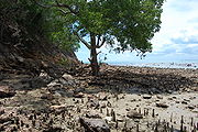
Estuaries
Estuaries are an example of a coastal sink in that they tend to trap sediment which can be due to tidal circulations and the mixing of fresh and salt water, the injection of river sediment and the presence of mangroveMangrove
Mangroves are various kinds of trees up to medium height and shrubs that grow in saline coastal sediment habitats in the tropics and subtropics – mainly between latitudes N and S...
s. As the tide rises and falls water and sediment is pumped into the estuary. Because salt water and sediment particles are heavier than fresh water they tend to be carried along the bottom until the sediment sinks to the floor and is trapped within the estuary. The movement of sands and offshore material into an estuary generally depends on the direction of longshore drift and the movement of bottom waters across the continental shelf
Continental shelf
The continental shelf is the extended perimeter of each continent and associated coastal plain. Much of the shelf was exposed during glacial periods, but is now submerged under relatively shallow seas and gulfs, and was similarly submerged during other interglacial periods. The continental margin,...
. Estuaries can often trap a lot of coarse bedload sediments that are feed down rivers, intercepting them before they reach the coast. The North Island
North Island
The North Island is one of the two main islands of New Zealand, separated from the much less populous South Island by Cook Strait. The island is in area, making it the world's 14th-largest island...
of New Zealand experiences sediment sinks into estuaries often, enhanced by the presence of mangroves. Mangroves are sediment hungry and trap a lot of suspended sediment with their complex aerial root
Root
In vascular plants, the root is the organ of a plant that typically lies below the surface of the soil. This is not always the case, however, since a root can also be aerial or aerating . Furthermore, a stem normally occurring below ground is not exceptional either...
structure, thus functioning as land builders.
Aeolian transport
Sand that is blown by the wind inland to form sand dunes usually develop on shorelines where there is suitably strong winds. This can be a major sink for the sediment budget of a shoreline.Longshore drift
Longshore drift of sediment is important for distributing sediment along the coast, and is considered one of the most important mechanisms. The longshore drift of sediment can be considered both a source and a sink due to the fact that in some case it can add sediment to a coastline but in others transport sediment away from a coastline. An example of both extremes of longshore drift can be found on the Canterbury coastline in New Zealand, either side of Banks Peninsular. Both the Waimakariri River in the north and the Canterbury Bight in the south of the Banks Peninsula provide large amounts of sediment respectively. The difference is the sediment supplied by the Waimakariri River is a source for the coast's New Brighton
New Brighton, New Zealand
New Brighton is a coastal suburb of Christchurch, New Zealand, about to the east of the city centre.-Naming:The naming of New Brighton was apparently done on a 'spur of moment' decision by William Fee, an early settler of the area...
spit
Spit (landform)
A spit or sandspit is a deposition landform found off coasts. At one end, spits connect to land, and extend into the sea. A spit is a type of bar or beach that develops where a re-entrant occurs, such as at cove's headlands, by the process of longshore drift...
due to the reversal of southern currents transporting sediment to the south. In contrast the Canterbury Bight has a combination of high energy environments and strong southern longshore currents that transport large amounts of sediment north, which can be classified as a sink, putting a deficit to the coasts sedimentary budget. As a result there is erosion of the Canterbury Bight and a predominantly balanced New Brighton Spit.
Models have been developed for measuring longshore drift which can assist in determining a sedimentary budget, if they are integrated over the correct timescale.
The sediment budget takes into consideration sediment source
Source
Source may refer to:-Research:* Source text, in research , a source of information referred to by citation** Primary source, firsthand written evidence of history made at the time of the event by someone who was present...
s and sinks within a system
System
System is a set of interacting or interdependent components forming an integrated whole....
. This sediment can come from any source with examples of sources and sinks consisting of:
- RiverRiverA river is a natural watercourse, usually freshwater, flowing towards an ocean, a lake, a sea, or another river. In a few cases, a river simply flows into the ground or dries up completely before reaching another body of water. Small rivers may also be called by several other names, including...
s - LagoonLagoonA lagoon is a body of shallow sea water or brackish water separated from the sea by some form of barrier. The EU's habitat directive defines lagoons as "expanses of shallow coastal salt water, of varying salinity or water volume, wholly or partially separated from the sea by sand banks or shingle,...
s - Eroding land sources
- Artificial sources e.g. nourishment
- Artificial sinks e.g. mining/extraction
- Offshore transport
- Deposition of sediment on shore
This sediment then enters the coastal system and is transported by longshore drift. A good example of the sediment budget and longshore drift working together in the coastal system is inlet
Inlet
An inlet is a narrow body of water between islands or leading inland from a larger body of water, often leading to an enclosed body of water, such as a sound, bay, lagoon or marsh. In sea coasts an inlet usually refers to the actual connection between a bay and the ocean and is often called an...
ebb-tidal shoals, which store sand that has been transported by long shore transport. As well as storing sand these systems may also transfer or by pass sand into other beach systems, therefore inlet ebb-tidal shoal
Shoal
Shoal, shoals or shoaling may mean:* Shoal, a sandbank or reef creating shallow water, especially where it forms a hazard to shipping* Shoal draught , of a boat with shallow draught which can pass over some shoals: see Draft...
systems provide a good sources and sinks for the sediment budget.
Cross-shore movement
Wave swashSwash
Swash, in geography, is a turbulent layer of water that washes up on the beach after an incoming wave has broken. The swash action can move beach material up and down on the beach, which results in the cross-shore sediment exchange. The time-scale of swash motion varies from seconds to minutes...
and currents can impact significantly on the sediment budget, although it is difficult to measure. Swash can be either an erosive or accretion process depending on many factors such as the sand texture and the individual wave itself. Although during fair weather the impact of swash is negligible, during storms the sea level can rise high enough to erode dunes and cliffs, dumping large quantities of sediment into the littoral cell, which can only be given back to the dune by aeolian transport. Where storm surge causes sediments to be deposited on the land from the littoral cell, they can form washover fans or open a new tidal inlet which transports sediment away from the littoral cell.
Coastal nourishment
When a coastal environment is in sediment deficit, anthropogenicAnthropogenic
Human impact on the environment or anthropogenic impact on the environment includes impacts on biophysical environments, biodiversity and other resources. The term anthropogenic designates an effect or object resulting from human activity. The term was first used in the technical sense by Russian...
sediment nourishment is one way in which a balanced sedimentary budget can be maintained. This type of coastal erosion management has been adopted all over the world in order to preserve and protect. An example of this is at Mount Maunganui
Mount Maunganui
Mount Maunganui is a town in the Bay of Plenty, New Zealand, located on a peninsula to the north of Tauranga. It was independent from Tauranga until the completion of the Tauranga Harbour Bridge in 1988....
beach in the North Island of New Zealand which had been experiencing erosion, resulting in coastal dune retreat of almost 20 metres. When ongoing dredging at the entrance to the Tauranga Harbour began, it was decided that the sediment removed would be used to re-nourish the Mt. Manganui beach. The sediment was deposited in the nearshore zone promoting beach accretion by offshore berm emplacement. Results show that most of the 80,000m3 of sediment added to the nearshore zone made it to ashore to re-nourish the beach and even out the past sediment deficit. Nourishment of a coast can be regarded as a fast fix option to reversing a sediment deficit; however, it is important that nourishment is on-going in order to ensure the sedimentary budget remains balanced.
Coastal protection
When protecting the coastline it is important to understand the how the sedimentary budget can be affected when implementing appropriate coastal protecting techniques. Often management plans for coastal erosion have seen the use of ‘hard’ engineering structures as a means of protecting the coastline from recession. In particular groyneGroyne
A groyne is a rigid hydraulic structure built from an ocean shore or from a bank that interrupts water flow and limits the movement of sediment. In the ocean, groynes create beaches, or avoid having them washed away by longshore drift. In a river, groynes prevent erosion and ice-jamming, which...
s which are used to trap the longshore drift of sediment that often deprives a beach. Groynes have the ability to change the coast's sediment budget, accreting up drift beaches but at the same time starving down drift beaches. This management approach is not used so much these days, with modern knowledge of coastal dynamics promoting the use of ‘soft’, natural approaches such as nourishment and preservation of natural systems such as dunes.
Coastal planning
Being able to incorporate the sedimentary budget in to a coastal management plan is becoming critical, especially in today's world where the majority of populations are living and owning property very close to the coast. One of the essential components drawn from sediment budget is being able to predict the morphological change that is likely to occur to a coastline over time, especially when creating plans associated with major environmental change such as sea level rise. Incorporating a sediment budget into a coastal plan has been recognised as highly important in the Hawke's Bay of New Zealand for finding information relating to hazardHazard
A hazard is a situation that poses a level of threat to life, health, property, or environment. Most hazards are dormant or potential, with only a theoretical risk of harm; however, once a hazard becomes "active", it can create an emergency situation. A hazard does not exist when it is not...
zones, beach property protection, and coastal erosion as well as assess the successfulness of current management strategies. The major setback with using the sediment budget for management and what is probably the underlining issue regarding the sediment budget is its complexity.
Further reading
- Bishop, P. and Cowell, P., 1997. Lithological and drainage network determinants of the character of drowned, embayed coastlines. Journal of Geology, 105, 685-699.
- Cowell, P. J., Stive, M.J F., Niedoroda, A.W., de Vriend, H.J., Swift, D.J.P., Kaminsky, G.M. and Capobianco, M., 2003a. The coastal-tract (part 1): A conceptual approach to aggregated modeling of low order coastal change. Journal of Coastal Research, 19, 812-827.
- Cowell, P. J., Stive, M.J.F., Niedoroda, A.W., Swift, D.J.P., de Vriend, H.J., Buijsman, M.C., Nicholls, R.J., Roy, P.S., Kaminsky, G.M., Cleveringa, J., Reed, C.W. and de Boer, P.L., 2003b. The coastal-tract (part 2): Applications of aggregated modeling of lower-order coastal change. Journal of Coastal Research, 19, 828-848.
- Davies, J. L., 1974. The coastal sediment compartment. Australian Geographical Studies, 12, 139-151.
- Sanderson, P. G and Eliot, I. 1999. Compartmentalisation of beachface sediments along the southwestern coast of Australia. Marine Geology 162, 145-164.
- Short, A.D. 2010. Sediment transport around Australia – sources, mechanisms, rates and barrier forms. Journal of Coastal Research, 26(3) 395-402.