

Waitaki River
Encyclopedia
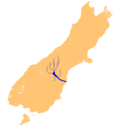
River
A river is a natural watercourse, usually freshwater, flowing towards an ocean, a lake, a sea, or another river. In a few cases, a river simply flows into the ground or dries up completely before reaching another body of water. Small rivers may also be called by several other names, including...
in the South Island
South Island
The South Island is the larger of the two major islands of New Zealand, the other being the more populous North Island. It is bordered to the north by Cook Strait, to the west by the Tasman Sea, to the south and east by the Pacific Ocean...
of New Zealand
New Zealand
New Zealand is an island country in the south-western Pacific Ocean comprising two main landmasses and numerous smaller islands. The country is situated some east of Australia across the Tasman Sea, and roughly south of the Pacific island nations of New Caledonia, Fiji, and Tonga...
, some 110 km long. It is the major river of the Mackenzie Basin
Mackenzie Basin
The Mackenzie Basin , is an elliptical intermontane basin, located in the Mackenzie and Waitaki Districts, near the centre of the South Island of New Zealand. It is the largest such basin in New Zealand...
.
It is a braided river
Braided river
A braided river is one of a number of channel types and has a channel that consists of a network of small channels separated by small and often temporary islands called braid bars or, in British usage, aits or eyots. Braided streams occur in rivers with high slope and/or large sediment load...
which flows through Lake Benmore
Lake Benmore
Lake Benmore is a lake located in the South Island of New Zealand. It was artificially created in the 1960s by construction of Benmore Dam. The lake covers an area of approximately 75 km²...
, Lake Aviemore
Lake Aviemore
Lake Aviemore or Mahi Tikumu is a man-made lake in New Zealand's South Island, part of the Waitaki hydroelectric scheme. Immediately upstream is Lake Benmore and downstream Lake Waitaki...
and Lake Waitaki
Lake Waitaki
Lake Waitaki is the smallest, oldest and farthest downstream of the three man-made lakes of the Waitaki hydroelectric project in New Zealand's South Island. It lies below lakes Aviemore and Benmore on the Waitaki River, close to the town of Kurow...
. These are ultimately fed by three large glacial lakes, Pukaki
Lake Pukaki
Lake Pukaki is the largest of three roughly parallel alpine lakes running north-south along the northern edge of the Mackenzie Basin on New Zealand's South Island. The others are Lakes Tekapo and Ohau...
, Tekapo, and Ohau
Lake Ohau
Lake Ohau is a glacial lake in the Mackenzie Basin of New Zealand's South Island. It is fed by the Hopkins and Dobson rivers, which have their headwaters in the Southern Alps, and has its outflow in the Ohau River, which itself feeds into the Waitaki River hydroelectric project.Ohau is the smallest...
. Lake Benmore and Lake Aviemore are contained by hydroelectric
Hydroelectricity
Hydroelectricity is the term referring to electricity generated by hydropower; the production of electrical power through the use of the gravitational force of falling or flowing water. It is the most widely used form of renewable energy...
dams, Benmore Dam
Benmore Dam
Benmore Dam is the largest dam within the Waitaki power scheme, located in the Canterbury Region of New Zealand's South Island. There are eight other power stations in the valley....
and Aviemore Dam
Aviemore Dam
The Aviemore Dam is a dam of the Waitaki River in New Zealand. Built from earth and concrete in the 1960s to dam Lake Aviemore, it is one of the major dams of Meridian Energy, and is used to power a hydroelectric power plant...
.
The Waitaki has several tributaries, notably the Ahuriri River
Ahuriri River
The Ahuriri River is a river in the Otago region of the South Island of New Zealand.The headwaters are on the eastern flanks of the Southern Alps. The river flows for 70 kilometres through the southernmost part of the Mackenzie Basin before reaching the Ahuriri Arm of Lake Benmore, one of the...
and the Hakataramea River
Hakataramea River
The Hakataramea River flows generally south through the Hakataramea Valley, which is separated from the more inland Mackenzie Basin by the Kirkliston Range in Canterbury, New Zealand....
. It passes Kurow
Kurow
Kurow is a town in the Waitaki Valley in the South Island of New Zealand, 55 kilometres inland from OamaruThe name of the town is an Anglicised form of the name of the nearby mountain Te Kohurau....
and Glenavy
Glenavy, New Zealand
Glenavy is a locality in the South Island of New Zealand. It is located at the southern extreme of the Canterbury region on the alluvial fan of the Waitaki River, three kilometres from the river's outflow into the Pacific Ocean....
before entering the Pacific Ocean
Pacific Ocean
The Pacific Ocean is the largest of the Earth's oceanic divisions. It extends from the Arctic in the north to the Southern Ocean in the south, bounded by Asia and Australia in the west, and the Americas in the east.At 165.2 million square kilometres in area, this largest division of the World...
between Timaru
Timaru
TimaruUrban AreaPopulation:27,200Extent:Former Timaru City CouncilTerritorial AuthorityName:Timaru District CouncilPopulation:42,867 Land area:2,736.54 km² Mayor:Janie AnnearWebsite:...
and Oamaru
Oamaru
Oamaru , the largest town in North Otago, in the South Island of New Zealand, is the main town in the Waitaki District. It is 80 kilometres south of Timaru and 120 kilometres north of Dunedin, on the Pacific coast, and State Highway 1 and the railway Main South Line connects it to both...
on the east coast of the South Island.
The river’s flow is normally low in winter, with flows increasing in spring when the snow cloaking the Southern Alps begins to melt, with flows throughout the summer being rainfall dependent and then declining in the autumn as the colder weather begins to freeze the smaller streams and streams which feed the catchment.
The median flow of the Waitaki River at Kurow is 356 cubic metres per second.
The middle of the river bed forms a political boundary between the Canterbury
Canterbury, New Zealand
The New Zealand region of Canterbury is mainly composed of the Canterbury Plains and the surrounding mountains. Its main city, Christchurch, hosts the main office of the Christchurch City Council, the Canterbury Regional Council - called Environment Canterbury - and the University of Canterbury.-...
and Otago
Otago
Otago is a region of New Zealand in the south of the South Island. The region covers an area of approximately making it the country's second largest region. The population of Otago is...
regions
Regions of New Zealand
The region is the top tier of local government in New Zealand. There are 16 regions of New Zealand. Eleven are governed by an elected regional council, while five are governed by territorial authorities which also perform the functions of a regional council and thus are known as unitary authorities...
. As such, the term "South of the Waitaki" is often used to refer to the Otago and Southland regions as one common area (the two regions share historical and ethnic relationships which make them distinct from the regions to the north of them).
In 2001 a proposal for a series of canals and dams was made by Meridian Energy
Meridian Energy
Meridian Energy Limited is a New Zealand state-owned electricity generator and retailer. The company generates the largest proportion of New Zealand's electricity, generating 32 percent of the country's electricity in the year ending 31 December 2009, and is the fourth-equal largest retailer, with...
for irrigation and electricity generation on the river. This scheme, known as Project Aqua
Project Aqua
Project Aqua is an abandoned hydroelectric scheme once proposed for the lower Waitaki River in New Zealand. Although the scheme had considerable support from some locals, it met with considerable opposition from others, and Meridian Energy decided in March 2004 not to go ahead with the project.The...
, planned to divert up to 77% of the lower river's flow to create a hydroelectric scheme, but these plans were dropped in March 2004. Lack of commercial viability was given as the major reason for the scheme's shelving, although strenuous public protest may also have been a major contributing factor, but a more modest successor scheme, the North Bank tunnel
North Bank tunnel
The North Bank tunnel concept is a hydroelectric scheme being developed by Meridian Energy on the Waitaki River in Canterbury, New Zealand. The $993 million project is expected to produce an additional 1100 to 1400 GWh pa, and take up to 260 m³/s of water from Lake Waitaki...
looks likely to proceed, with water rights being granted in September 2009.
The river is popular for recreational fishing
Fishing
Fishing is the activity of trying to catch wild fish. Fish are normally caught in the wild. Techniques for catching fish include hand gathering, spearing, netting, angling and trapping....
and jetboat
Jetboat
A jetboat is a boat propelled by a jet of water ejected from the back of the craft. Unlike a powerboat or motorboat that uses a propeller in the water below or behind the boat, a jetboat draws the water from under the boat into a pump inside the boat, then expels it through a nozzle at the...
ing.